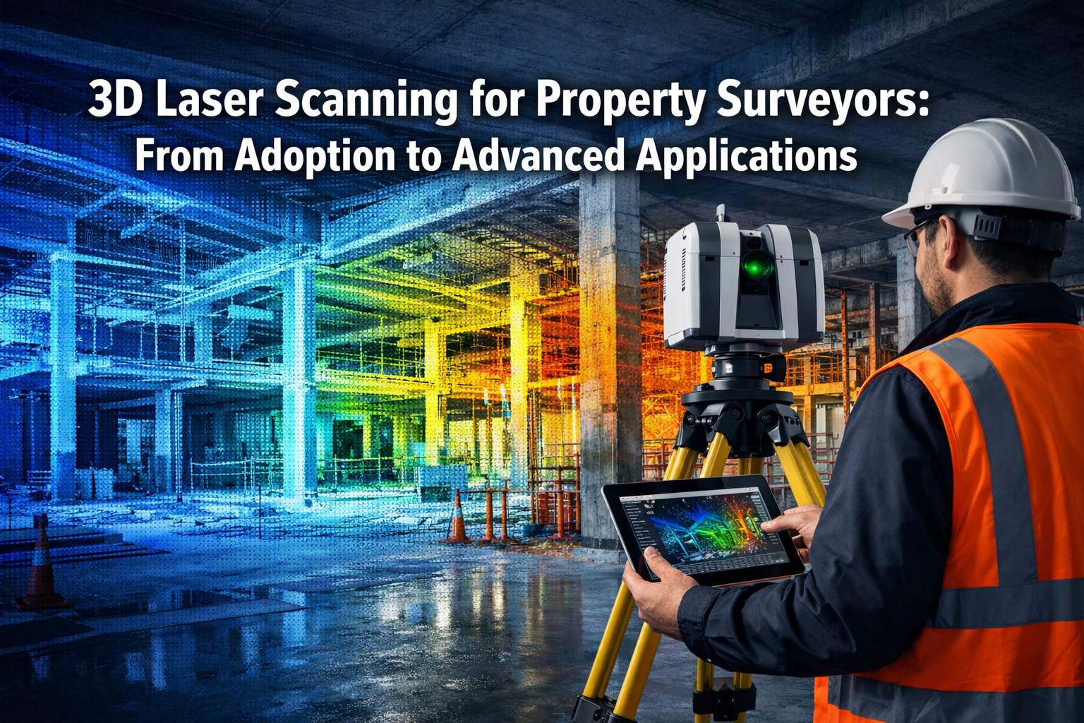
The property surveying industry stands at a technological crossroads in 2026, where precision, speed, and comprehensive data capture have become non-negotiable requirements. 3D Laser Scanning for Property Surveyors: From Adoption to Advanced Applications represents not just a technological evolution but a fundamental transformation in how professionals approach measurement, documentation, and analysis. As the 3D laser scanning services market surges toward $12.85 billion by 2030[8], property surveyors who embrace this technology position themselves at the forefront of an industry revolution that combines unprecedented accuracy with remarkable efficiency gains.
Traditional surveying methods, while reliable and legally established, simply cannot match the 5-10 times faster data collection that 3D laser scanning delivers[2]. When a complex building documentation project shrinks from weeks to mere hours, the competitive advantage becomes undeniable. Yet adoption requires more than purchasing equipment—it demands understanding the technology's capabilities, mastering new workflows, and recognizing where laser scanning complements rather than replaces traditional methods.
Key Takeaways
- Market momentum: The 3D laser scanning services sector is experiencing 7.5% annual growth, driven by AI digital twins and infrastructure applications, creating expanding opportunities for property surveyors[8]
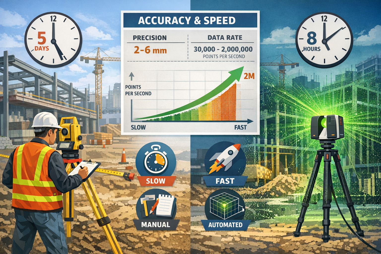
- Precision advantage: Modern terrestrial laser scanners achieve 2-6 millimeter accuracy across entire surfaces, with high-end systems reaching sub-millimeter precision—far exceeding traditional measurement capabilities[2]
- Speed transformation: Data collection completes 5-10 times faster than conventional methods, with commercial systems capturing up to 2 million points per second[1][4]
- Hybrid approach success: Leading surveyors combine traditional methods for control networks and legal boundaries with 3D scanning for detailed documentation, maximizing both legal certainty and comprehensive data capture[2]
- Accessibility improvements: Declining hardware costs, user-friendly interfaces, and integration with existing software packages are reducing adoption barriers for surveying professionals[1]
Understanding 3D Laser Scanning Technology for Property Surveyors
What Is 3D Laser Scanning?
3D laser scanning, also known as LiDAR (Light Detection and Ranging), represents a non-contact, non-destructive technology that captures the precise three-dimensional shape of physical objects and environments. The system works by emitting rapid laser pulses that reflect off surfaces and return to the scanner's sensor. By measuring the time each pulse takes to return and calculating distances using the speed of light, the scanner creates millions of precisely positioned measurement points called a "point cloud"[3].
Modern commercial systems achieve remarkable data acquisition rates, capturing 30,000 to 2 million points per second depending on the configuration[1][4]. This speed enables comprehensive documentation of complex structures in timeframes that would be impossible with traditional measurement techniques.
Core Components of Laser Scanning Systems
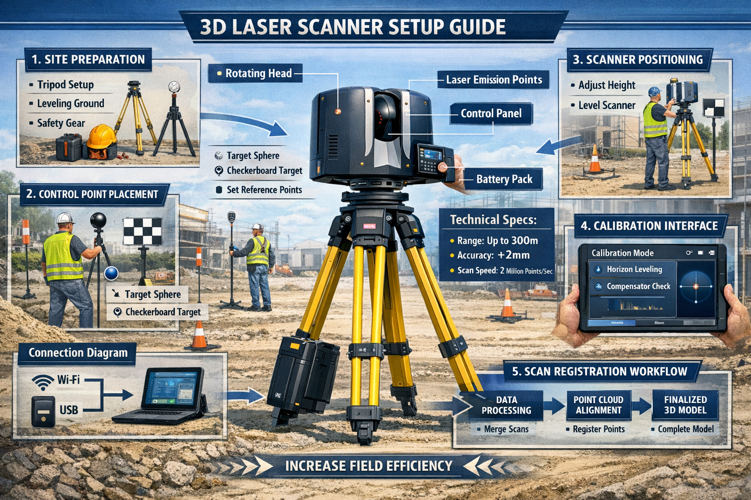
A complete 3D laser scanning setup for property surveying typically includes:
Hardware Components:
- Terrestrial laser scanner: The primary measurement device, mounted on a stable tripod
- Control targets: Reflective spheres or checkerboard patterns for scan registration
- Power supply: Battery packs for field operation
- Data storage: High-capacity drives for point cloud data
- Computing device: Tablet or laptop for scanner control and field verification
Software Elements:
- Scan registration software: Aligns multiple scans into unified coordinate systems
- Point cloud processing tools: Filters, classifies, and optimizes raw data
- CAD/BIM integration platforms: Converts point clouds into usable design formats
- Analysis applications: Enables measurements, comparisons, and reporting
Accuracy Specifications and Performance Metrics
The accuracy specifications of 3D laser scanning systems significantly exceed traditional surveying methods for surface documentation. Modern terrestrial laser scanners achieve 2-6 millimeters accuracy across entire surfaces, with specialized high-end systems reaching sub-millimeter precision[2]. This level of accuracy applies to millions of measurement points simultaneously, creating comprehensive surface models rather than individual spot measurements.
| Measurement Method | Typical Accuracy | Points Captured | Time Required |
|---|---|---|---|
| Traditional Total Station | 2-5mm per point | 100-500 points/day | Days to weeks |
| 3D Laser Scanning | 2-6mm surface accuracy | Millions of points/hour | Hours to days |
| Photogrammetry | 5-20mm | Thousands to millions | Hours to days |
| GPS/GNSS | 10-50mm | Individual points | Variable |
The comprehensive nature of point cloud data provides an additional advantage: environmental context capture. Scanning systems document everything within their field of view, creating datasets that capture details beyond the original project scope without requiring additional site visits[1]. This "insurance policy" of comprehensive data proves invaluable when project requirements expand or unforeseen questions arise.
The Adoption Journey: From Traditional Methods to 3D Laser Scanning for Property Surveyors
Why Property Surveyors Are Making the Transition
The shift toward 3D Laser Scanning for Property Surveyors: From Adoption to Advanced Applications stems from multiple converging factors that make adoption increasingly practical and profitable in 2026.
Economic Drivers:
Hardware costs have dropped significantly compared to ten years ago while performance has improved dramatically[1]. Entry-level terrestrial laser scanners now cost a fraction of historical prices, with scanning modules integrable into existing software packages, limiting new purchase requirements. This democratization of technology places advanced capabilities within reach of small and medium-sized surveying firms, not just large corporations.
The return on investment manifests through increased project capacity. When a surveyor completes data collection 5-10 times faster[2], the same team can handle substantially more projects annually, directly impacting revenue potential. Additionally, the comprehensive data capture reduces callbacks and repeat site visits, further improving operational efficiency.
Client Expectations:
Property developers, architects, and facility managers increasingly request—and sometimes require—point cloud deliverables. Chartered surveyors across London and surrounding regions report growing client sophistication regarding digital documentation standards. Building Information Modeling (BIM) workflows, digital twins, and facility management systems all integrate more seamlessly with point cloud data than traditional survey deliverables.
Safety Considerations:
Extended scanning range enables "virtual surveying" through remote or autonomous devices, allowing operators to maintain distance from hazardous environments such as busy roadways, mines, and tunnels[1]. For surveyors working in Central London and other high-traffic urban areas, this safety advantage proves particularly valuable when documenting buildings adjacent to active construction zones or busy streets.
Overcoming Adoption Barriers
Despite clear advantages, property surveyors face legitimate concerns when considering 3D laser scanning adoption:
Learning Curve Concerns:
User-friendly interfaces and intuitive platforms, combined with tailored training programs, are reducing adoption barriers for professionals transitioning to scanning technology in existing workflows[1]. Modern systems feature:
- Automated workflows: Self-calibration and in-field registration minimize technical expertise requirements
- Real-time feedback: Immediate scan preview detects gaps and errors without returning to sites
- Guided processes: Step-by-step interfaces walk operators through scanning procedures
- Integration support: Manufacturers provide training on incorporating scans into existing CAD and surveying software
Legal and Professional Standards:
Traditional surveying methods carry established legal precedents and professional standards. Many surveyors question whether laser scanning data holds equivalent weight in boundary disputes, easement determinations, and legal descriptions.
The solution lies in hybrid methodology adoption: successful projects combine traditional surveying for control networks and boundary establishment with 3D laser scanning for detailed documentation and analysis, leveraging legal certainty with comprehensive data capture[2]. This approach maintains compliance with established standards while capturing the efficiency and completeness advantages of scanning technology.
Building a Business Case for Investment
Developing a compelling business case for 3D laser scanning investment requires analyzing specific practice areas and client needs:
Target Application Assessment:
Identify which services benefit most from scanning capabilities:
- ✅ As-built documentation for renovations and additions
- ✅ Heritage building preservation requiring non-invasive measurement
- ✅ Complex structural analysis needing comprehensive surface data
- ✅ Construction progress monitoring tracking changes over time
- ✅ Facility management supporting ongoing maintenance planning
- ✅ Disaster assessment enabling rapid damage documentation
Financial Modeling:
Calculate expected returns based on:
- Increased project capacity: Additional projects completed annually due to faster data collection
- Premium pricing: Higher fees for advanced deliverables and specialized services
- Reduced callbacks: Fewer repeat site visits due to comprehensive initial data capture
- New service offerings: Revenue from previously unavailable specialized scanning services
- Competitive positioning: Market share gains from technological differentiation
Phased Implementation:
Consider graduated adoption approaches:
- Partnership phase: Subcontract scanning services for initial projects to test market demand
- Entry-level investment: Purchase affordable handheld or entry-level scanners for specific applications
- Full capability development: Invest in terrestrial laser scanners and comprehensive software suites
- Advanced specialization: Add mobile scanning, UAV-mounted systems, or specialized applications
Setup Guides and Operational Best Practices for 3D Laser Scanning
Pre-Scan Planning and Site Preparation
Successful 3D laser scanning projects begin long before arriving on site. Thorough planning maximizes efficiency and ensures complete data capture.
Project Scoping:
Define clear objectives and deliverables:
- Accuracy requirements: Determine necessary precision levels for intended applications
- Coverage area: Identify all spaces, facades, and features requiring documentation
- Deliverable formats: Specify point cloud formats, CAD drawings, BIM models, or other outputs
- Timeline constraints: Establish field work windows and processing deadlines
Site Assessment:
Conduct preliminary site evaluation to identify:
- Access points: Entry locations and pathways for equipment transport
- Scanning positions: Optimal scanner placement locations for complete coverage
- Obstructions: Furniture, equipment, or features requiring relocation or special attention
- Safety hazards: Electrical systems, unstable structures, or environmental dangers
- Lighting conditions: Natural and artificial lighting that may affect scanning performance
Equipment Preparation:
Ensure all systems are field-ready:
- ✅ Battery charging: Full power for all devices with backup batteries
- ✅ Data storage: Sufficient capacity with formatted drives
- ✅ Target preparation: Clean, properly sized control targets
- ✅ Calibration verification: Recent calibration certificates and test scans
- ✅ Software updates: Current firmware and application versions
Field Scanning Procedures
Executing efficient field scanning requires systematic approaches that balance thoroughness with productivity.
Scanner Setup and Positioning:
- Establish control network: Place control targets in fixed positions visible from multiple scan locations
- Position scanner: Set up tripod on stable surface with level verification
- Initial calibration: Perform automated calibration routines per manufacturer specifications
- Coverage planning: Visualize scan positions ensuring 30-40% overlap between adjacent scans
Scan Execution Workflow:
Modern systems enable in-field registration, automatic calibration, and real-time scan review to detect gaps and correct errors without returning to sites[1]. Optimize field time through:
- Progressive scanning: Begin with perimeter scans, then fill interior areas systematically
- Real-time quality checks: Review point cloud density and coverage during acquisition
- Field annotations: Add notes and measurements during active scanning to maximize operational time[1]
- Redundancy planning: Capture additional scans in critical areas as insurance against data gaps
Environmental Considerations:
Adapt scanning parameters to site conditions:
- Reflective surfaces: Adjust laser intensity for glass, metal, and polished materials
- Lighting variations: Account for bright sunlight, shadows, and artificial lighting
- Moving objects: Time scans to avoid vehicles, people, and equipment in critical areas
- Weather conditions: Protect equipment from precipitation, extreme temperatures, and wind
Post-Processing and Data Management
Raw point cloud data requires processing before delivering useful surveying products.
Registration and Alignment:
Combine individual scans into unified datasets:
- Target-based registration: Align scans using control targets with automated recognition
- Cloud-to-cloud registration: Match overlapping geometry for targetless alignment
- Georeferencing: Integrate survey control points for absolute positioning
- Accuracy verification: Check registration errors and refine alignment as needed
Point Cloud Optimization:
Prepare data for analysis and deliverable creation:
- Noise filtering: Remove erroneous points from reflections, moving objects, and edge effects
- Decimation: Reduce point density while maintaining accuracy for manageable file sizes
- Classification: Identify and label different surface types, materials, and features
- Colorization: Apply RGB values from scanner cameras for photorealistic visualization
Deliverable Creation:
Transform point clouds into client-ready products:
- CAD drawings: Extract floor plans, elevations, sections, and details
- BIM models: Create intelligent 3D models with parametric objects
- Mesh models: Generate surface meshes for visualization and analysis
- Measurement reports: Document dimensions, areas, volumes, and comparisons
- Animation and visualization: Produce flythrough videos and interactive viewers
Accuracy Comparisons: 3D Laser Scanning for Property Surveyors vs. Traditional Methods
Precision Performance Analysis
Understanding when 3D laser scanning provides superior accuracy versus traditional methods requires examining specific measurement scenarios.
Surface Documentation:
For comprehensive surface capture, laser scanning delivers unmatched performance. A single scan position captures millions of data points in minutes[1], creating complete surface models with 2-6mm accuracy[2] across the entire area. Traditional total station measurements, while achieving similar point-to-point precision, require individual measurements of each location—a physical impossibility for complex curved surfaces or extensive facades.
Example Comparison – Building Facade Documentation:
- Traditional method: 200-300 spot measurements over 2-3 days, interpolating between points
- Laser scanning: 50+ million surface points in 2-4 hours, complete surface capture
- Result: Laser scanning reveals architectural details, deformations, and irregularities invisible to traditional methods
Boundary and Control Surveying:
For establishing legal boundaries and precise control networks, traditional surveying methods maintain advantages. Total stations and GPS/GNSS systems provide:
- Established legal precedent: Accepted methodology in boundary disputes and legal descriptions
- Point-specific precision: Extremely accurate individual point determination
- Professional standards compliance: Alignment with licensing requirements and professional practice standards
The hybrid methodology approach combines these strengths: establish control networks and boundaries with traditional methods, then use 3D scanning for detailed documentation referenced to that control[2].
Application-Specific Accuracy Requirements
Different surveying applications demand varying accuracy levels, influencing technology selection.
| Application | Required Accuracy | Optimal Technology | Typical Deliverable |
|---|---|---|---|
| Boundary surveys | ±5-10mm | Total station + GPS | Legal descriptions, plats |
| As-built documentation | ±10-25mm | 3D laser scanning | Point clouds, CAD drawings |
| Dilapidation surveys | ±5-15mm | Hybrid approach | Condition reports, comparisons |
| Heritage preservation | ±2-5mm | High-precision scanning | Archival models, restoration plans |
| Construction monitoring | ±10-20mm | Periodic scanning | Progress tracking, deviation analysis |
| Drone roof surveys | ±20-50mm | UAV photogrammetry/LiDAR | Orthophotos, 3D models |
Quality Assurance and Verification
Maintaining accuracy standards requires systematic verification procedures:
Field Quality Control:
- ✅ Redundant measurements: Capture overlapping scans with 30-40% overlap for verification
- ✅ Check targets: Include known-distance targets for accuracy validation
- ✅ Real-time review: Examine point cloud density and coverage during acquisition
- ✅ Control point verification: Re-measure survey control with independent methods
Processing Quality Control:
- ✅ Registration error analysis: Review alignment statistics and refine as needed
- ✅ Comparison to control: Verify point cloud accuracy against survey control network
- ✅ Cross-section validation: Extract profiles and compare to traditional measurements
- ✅ Independent verification: Have second technician review processing workflow
Advanced Applications: Construction Progress Monitoring and Disaster Management
Construction Progress Monitoring with 3D Laser Scanning
The construction industry increasingly relies on 3D Laser Scanning for Property Surveyors: From Adoption to Advanced Applications to track project progress, verify compliance, and manage quality control.
Periodic Scanning Workflows:
Establish scanning schedules aligned with construction milestones:
- Foundation stage: Document excavation, formwork, and structural elements
- Framing completion: Verify structural positioning and dimensional accuracy
- MEP rough-in: Capture mechanical, electrical, and plumbing installations
- Pre-closeup inspection: Document conditions before wall and ceiling closure
- Final completion: Create as-built documentation for facility management
BIM Comparison and Clash Detection:
Point cloud data integrates directly with BIM software to support:
- Design vs. reality analysis: Compare as-built conditions to design models, identifying deviations
- Clash detection: Discover conflicts between building systems before costly corrections
- Change documentation: Track modifications and field changes for accurate as-builts
- Quality verification: Confirm installation accuracy for critical systems and components
Quantification and Progress Tracking:
Automated analysis tools extract valuable metrics:
- Volume calculations: Measure excavation, concrete pours, and material quantities
- Completion percentages: Calculate installed versus remaining work by building system
- Schedule verification: Validate contractor progress claims against physical conditions
- Payment applications: Provide objective data supporting progress payments
Disaster Assessment and Emergency Response
When disasters strike, rapid and accurate damage assessment becomes critical for emergency response, insurance claims, and reconstruction planning.
Safety-First Documentation:
Extended scanning range enables documentation from safe distances, allowing operators to maintain distance from hazardous environments[1]. This capability proves essential when assessing:
- Structurally compromised buildings: Document damage without entering unstable structures
- Fire-damaged properties: Capture conditions while avoiding collapse hazards
- Flood-affected facilities: Record damage from safe positions during ongoing water presence
- Chemical or biological contamination: Scan affected areas without exposure risks
Rapid Damage Quantification:
Speed advantages of laser scanning support time-critical decisions:
- Immediate structural assessment: Identify critical damage requiring emergency stabilization
- Salvage prioritization: Determine which contents and materials can be recovered
- Demolition planning: Document pre-demolition conditions and plan safe removal sequences
- Insurance documentation: Create comprehensive damage records supporting claims
Reconstruction Planning:
Point cloud data facilitates efficient rebuilding:
- Baseline documentation: Establish pre-disaster conditions for restoration guidance
- Dimensional verification: Provide accurate measurements for material ordering and fabrication
- Phased reconstruction: Plan sequential repairs based on comprehensive site understanding
- Historical preservation: Support heritage building restoration with detailed documentation
Infrastructure Assessment and Monitoring
Transportation infrastructure, utilities, and civil works benefit substantially from 3D laser scanning capabilities.
Bridge and Roadway Documentation:
Safety challenges of traditional surveying on active roadways make laser scanning particularly valuable:
- Mobile scanning: Capture roadway conditions at traffic speeds without lane closures
- Structural inspection: Document bridge components, clearances, and deformations
- Pavement analysis: Measure surface conditions, rutting, and deterioration
- Clearance verification: Verify overhead and lateral clearances for oversized loads
Tunnel and Underground Infrastructure:
Confined spaces and difficult access make scanning ideal for:
- Convergence monitoring: Track tunnel deformation and stability over time
- Clearance verification: Ensure adequate space for equipment and vehicles
- Condition assessment: Document deterioration, cracking, and maintenance needs
- As-built documentation: Create accurate models of complex underground systems
Integration with Digital Workflows and Emerging Technologies
Building Information Modeling (BIM) Integration
The connection between 3D laser scanning and BIM represents one of the most powerful synergies in modern construction and facility management.
Scan-to-BIM Workflows:
Converting point clouds to intelligent BIM models involves:
- Point cloud import: Load registered scans into BIM authoring software
- Model creation: Build parametric objects (walls, floors, structural elements) referenced to point cloud
- Detail refinement: Add architectural features, openings, and building systems
- Accuracy verification: Compare finished model to source point cloud, verifying tolerances
- Information enrichment: Add non-geometric data (materials, specifications, maintenance schedules)
Facility Management Applications:
Property owners and facility managers leverage scan-derived BIM models for:
- Space management: Accurate floor plans supporting space allocation and planning
- Maintenance planning: Visual documentation of systems and components for service scheduling
- Renovation design: Existing conditions models enabling accurate design development
- Emergency response: Building information supporting fire, security, and emergency services
Digital Twin Development
Digital twins—virtual replicas of physical assets updated with real-time data—represent the cutting edge of facility management technology. The 3D laser scanning services market growth toward $12.85 billion by 2030 is driven primarily by AI digital twins applications[8].
Digital Twin Components:
Comprehensive digital twins combine:
- Geometric foundation: Point cloud-derived 3D models providing spatial framework
- IoT sensor integration: Real-time data from building systems (HVAC, lighting, security)
- Operational data: Energy consumption, occupancy patterns, maintenance records
- Predictive analytics: AI-driven forecasting of system performance and maintenance needs
Periodic Scanning Updates:
Maintaining digital twin accuracy requires regular scanning:
- Annual baseline scans: Update geometric model reflecting renovations and modifications
- Change detection: Compare current scans to historical data, identifying alterations
- Condition monitoring: Track deterioration, settlement, and structural changes
- Verification scanning: Confirm sensor data accuracy against physical measurements
Artificial Intelligence and Automated Processing
AI and machine learning technologies are transforming point cloud processing from manual tasks to automated workflows.
Automated Feature Extraction:
Machine learning algorithms identify and classify:
- Building elements: Walls, floors, ceilings, doors, windows automatically detected and modeled
- Building systems: MEP components recognized and categorized
- Vegetation and terrain: Natural features separated from built structures
- Damage and defects: Cracks, deformations, and deterioration automatically flagged
Quality Control Automation:
AI-powered analysis enhances accuracy verification:
- Registration optimization: Automated alignment refinement improving accuracy
- Noise detection: Intelligent filtering removing erroneous points
- Completeness checking: Gap detection ensuring comprehensive coverage
- Accuracy reporting: Automated deviation analysis and reporting
Future Trends and Professional Development for Property Surveyors
Emerging Technologies Shaping the Industry
The future of 3D Laser Scanning for Property Surveyors: From Adoption to Advanced Applications extends beyond current capabilities into transformative new technologies.
Mobile and Wearable Scanning:
Handheld and backpack-mounted scanners enable:
- Rapid interior documentation: Walk-through scanning capturing complex interiors in minutes
- Difficult access areas: Scanning confined spaces and irregular pathways
- Reduced setup time: Continuous scanning without repeated tripod positioning
- Cost-effective solutions: Lower-cost systems suitable for smaller projects
UAV-Integrated Scanning:
Drone-mounted LiDAR systems expand surveying capabilities:
- Large area coverage: Rapid scanning of extensive sites and campuses
- Inaccessible locations: Roof documentation, cliff faces, and elevated structures
- Topographic mapping: Terrain modeling with vegetation penetration
- Infrastructure inspection: Bridges, towers, and utility corridors
Real-Time Processing:
Edge computing and improved processing power enable:
- Instant visualization: Immediate point cloud viewing during acquisition
- Field decision-making: On-site analysis supporting real-time project decisions
- Automated quality control: Instant gap detection and coverage verification
- Reduced post-processing: Preliminary deliverables available immediately after scanning
Professional Development and Training
Successful adoption requires ongoing education and skill development.
Technical Competencies:
Property surveyors should develop proficiency in:
- ✅ Scanner operation: Equipment setup, calibration, and field procedures
- ✅ Registration techniques: Point cloud alignment and georeferencing
- ✅ Processing software: Point cloud manipulation and optimization
- ✅ CAD/BIM integration: Converting scans to design-ready deliverables
- ✅ Quality control: Accuracy verification and validation procedures
Training Resources:
Access education through:
- Manufacturer programs: Equipment vendors offer comprehensive training courses
- Professional associations: RICS, NSPS, and regional organizations provide continuing education
- Online platforms: Video tutorials, webinars, and virtual training sessions
- Peer learning: Local user groups and professional networks
- Academic programs: University courses and certificate programs in geomatics and scanning
Certification and Credentials:
Demonstrate expertise through:
- Manufacturer certifications: Vendor-specific credentials validating equipment proficiency
- Professional designations: Advanced credentials from surveying professional bodies
- Project portfolios: Documented case studies demonstrating successful applications
- Continuing education: Ongoing learning maintaining current knowledge
Business Strategy and Market Positioning
Leveraging 3D laser scanning for competitive advantage requires strategic planning.
Service Differentiation:
Distinguish your practice through:
- Specialized applications: Develop expertise in niche markets (heritage, industrial, infrastructure)
- Advanced deliverables: Offer sophisticated products (digital twins, BIM models, VR experiences)
- Rapid turnaround: Leverage scanning speed for time-critical projects
- Comprehensive documentation: Provide "insurance policy" data capture exceeding project requirements
Marketing and Client Education:
Communicate value effectively:
- Case studies: Document successful projects demonstrating ROI and advantages
- Visualization tools: Use point cloud animations and interactive viewers in presentations
- Educational content: Publish articles, videos, and guides explaining technology benefits
- Demonstration projects: Offer introductory scanning services showcasing capabilities
Partnership Development:
Expand capabilities through collaboration:
- Architect and engineer partnerships: Integrate scanning into design workflows
- Construction company relationships: Provide progress monitoring and quality control services
- Facility management contracts: Establish ongoing scanning and digital twin maintenance agreements
- Technology vendor relationships: Partner with software and hardware providers for referrals and support
Conclusion: Embracing the Future of Property Surveying
3D Laser Scanning for Property Surveyors: From Adoption to Advanced Applications represents far more than a technological upgrade—it embodies a fundamental transformation in how surveying professionals approach their craft. The convergence of declining costs, improving performance, and expanding applications creates an unprecedented opportunity for property surveyors to enhance service offerings, improve operational efficiency, and position themselves as technology leaders in a rapidly evolving industry.
The evidence supporting adoption is compelling: 5-10 times faster data collection[2], 2-6 millimeter accuracy[2], and comprehensive environmental capture that creates an "insurance policy" of complete documentation[1]. These advantages translate directly into competitive positioning, enabling surveyors to complete more projects, deliver superior products, and serve clients in ways traditional methods cannot match.
Success requires thoughtful implementation rather than hasty technology purchases. The hybrid approach—combining traditional surveying's legal certainty with 3D scanning's comprehensive data capture[2]—provides a proven pathway that maintains professional standards while embracing innovation. Starting with targeted applications, developing competencies systematically, and expanding capabilities as expertise grows creates sustainable adoption that builds on existing strengths rather than abandoning established practices.
Actionable Next Steps
For property surveyors ready to embrace 3D laser scanning technology:
Immediate Actions (Next 30 Days):
- Assess current practice: Identify which services would benefit most from scanning capabilities
- Research equipment options: Evaluate systems matching your application needs and budget
- Connect with experienced users: Join professional networks and user groups for peer insights
- Attend demonstrations: Experience equipment firsthand through vendor demonstrations and trade shows
- Develop preliminary business case: Calculate potential ROI based on your specific practice
Short-Term Implementation (3-6 Months):
- Secure training: Enroll in comprehensive courses covering equipment operation and processing
- Start with partnerships: Subcontract scanning services for initial projects to test market demand
- Build client awareness: Educate existing clients about scanning capabilities and benefits
- Develop workflows: Create standard procedures integrating scanning into existing practice
- Make initial investment: Purchase entry-level equipment or comprehensive systems based on business case
Long-Term Development (6-12 Months and Beyond):
- Expand service offerings: Develop specialized applications and advanced deliverables
- Pursue certifications: Obtain manufacturer and professional credentials validating expertise
- Measure and refine: Track project performance, client satisfaction, and financial returns
- Scale operations: Add equipment, personnel, and capabilities as demand grows
- Embrace emerging technologies: Stay current with AI integration, mobile scanning, and digital twins
The property surveying profession stands at a pivotal moment. Those who embrace 3D Laser Scanning for Property Surveyors: From Adoption to Advanced Applications position themselves not merely to survive industry transformation but to lead it. Whether serving clients in West London, Surrey, or beyond, the combination of traditional surveying expertise with advanced scanning capabilities creates a powerful professional foundation for success in 2026 and the years ahead.
The question is no longer whether to adopt 3D laser scanning, but how quickly and strategically to implement it. The market momentum is clear, the technology is proven, and the competitive advantages are substantial. The time to act is now.
References
[1] 3d Laser Scanning New Opportunities For Surveying And Mapping Professionals – https://geospatial.trimble.com/blog/geospatial/en-US/article/3d-laser-scanning-new-opportunities-for-surveying-and-mapping-professionals
[2] 3d Scanning Vs Traditional Surveying Guide – https://iscano.com/laser-scanning-lidar-best-practices/3d-scanning-vs-traditional-surveying-guide/
[3] 3d Laser Scanning Used In Land Surveying – https://www.duncan-parnell.com/blog/108/3d-laser-scanning-used-in-land-surveying
[4] When To Add 3d Laser Scanning To Your Surveying Capabilities – https://blog.hexagongeosystems.com/when-to-add-3d-laser-scanning-to-your-surveying-capabilities/
[5] The Future Of Land Surveying Technology And Upcoming Trends In 2026 – https://metricop.com/blogs/land-surveying/the-future-of-land-surveying-technology-and-upcoming-trends-in-2026
[6] How Technology Is Revolutionizing Land Surveys – https://www.firstchoicesurveying.com/blog/how-technology-is-revolutionizing-land-surveys
[7] 7 Reasons To Use Lidar Construction Laser Scanning – https://blog.brightergraphics.com/7-reasons-to-use-lidar-construction-laser-scanning
[8] 3d Laser Scanning Services Global Market Report – https://www.thebusinessresearchcompany.com/report/3d-laser-scanning-services-global-market-report