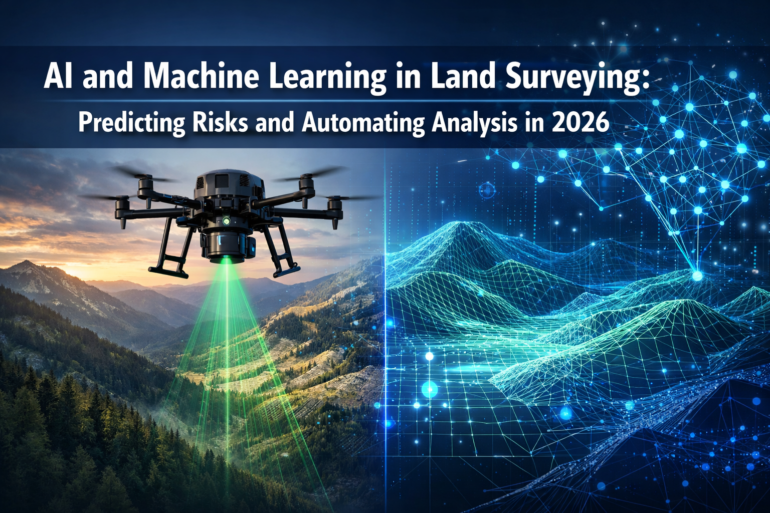
The land surveying industry stands at a transformative crossroads in 2026. What once required weeks of manual data processing, multiple site visits, and painstaking analysis now happens in hours—sometimes minutes. AI and Machine Learning in Land Surveying: Predicting Risks and Automating Analysis in 2026 represents not just an incremental improvement but a fundamental shift in how surveying professionals work, deliver results, and protect communities from environmental hazards. Surveyors who once spent countless hours sorting through point cloud data now watch as intelligent algorithms instantly classify terrain, identify markers, flag anomalies, and generate preliminary surface models without human intervention.[1]
This revolution extends far beyond simple automation. Machine learning systems now predict flooding patterns, identify landslide risks before they become catastrophic, and monitor structural changes in real-time—capabilities that seemed like science fiction just a few years ago. For property professionals seeking structural survey services, these advances mean faster, more accurate assessments with unprecedented risk insights.
Key Takeaways
✅ AI systems have moved from experimental to standard practice in 2026, with 94% of early-adopter surveying firms planning to increase AI usage, transforming data processing from weeks to hours.[6]
✅ Machine learning algorithms now predict environmental risks including flooding, landslides, and terrain instability by analyzing historical patterns and massive datasets that humans cannot process manually.[2]
✅ Multi-sensor drone systems capture comprehensive data in single flights that previously required multiple site visits, with AI-powered autonomous flight paths optimizing sensor selection and positioning.[1]
✅ Real-time monitoring and digital twins enable continuous structural and terrain change detection, providing critical data for construction monitoring, environmental studies, and infrastructure risk assessment.[2]
✅ Cloud-based platforms with AI integration have replaced static document delivery, enabling instant collaboration, 3D visualization, and automated quality checks throughout the surveying workflow.[1]
Understanding AI and Machine Learning Fundamentals in Modern Surveying

What Makes AI Different from Traditional Surveying Software
Traditional surveying software requires explicit programming for every task. If surveyors want the software to identify a boundary marker, developers must write specific code defining exactly what a marker looks like, where it might appear, and how to differentiate it from similar objects. This approach works but remains rigid and time-consuming.
Machine learning fundamentally changes this paradigm. Instead of programming explicit rules, surveyors train AI systems by showing them thousands of examples. The algorithm learns patterns, relationships, and characteristics on its own. When processing new survey data, the AI applies these learned patterns to make decisions, classifications, and predictions.[3]
In 2026, this distinction has profound practical implications:
| Traditional Software | AI-Powered Systems |
|---|---|
| Requires manual data sorting | Automatically classifies terrain types |
| Fixed processing rules | Adapts to new patterns and conditions |
| Cannot predict future conditions | Forecasts risks based on historical data |
| Sequential processing | Parallel analysis of multiple data streams |
| Limited to programmed scenarios | Identifies unexpected anomalies |
How Machine Learning Processes Massive Survey Datasets
Modern surveying projects generate staggering amounts of data. A single drone roof survey can produce millions of data points. LiDAR scans create point clouds with billions of measurements. Processing this information manually would take months—if it were even possible.
Machine learning algorithms excel at finding patterns in massive datasets.[2] These systems work through several stages:
Data Ingestion and Preprocessing 🔄
AI systems automatically import data from multiple sources—LiDAR sensors, photogrammetry cameras, GPS units, and ground control points. The algorithms clean the data, removing noise and correcting obvious errors without human intervention.
Feature Recognition and Classification 🎯
Trained neural networks identify specific elements within the data: buildings, vegetation, water bodies, roads, elevation changes, and terrain characteristics. The AI classifies each point or pixel based on learned patterns, creating organized datasets from raw information.[3]
Pattern Detection and Analysis 📊
Machine learning algorithms identify relationships and patterns that human analysts might miss. They detect subtle elevation changes indicating subsidence, recognize vegetation patterns suggesting drainage issues, and spot structural anomalies that warrant further investigation.
Anomaly Flagging and Quality Control ⚠️
AI-assisted quality checks now integrate into standard review pipelines, alerting surveyors to inconsistencies before projects reach the drafting stage.[1] This provides additional safeguards beyond traditional review methods, catching errors that might otherwise go unnoticed until construction begins.
AI and Machine Learning in Land Surveying: Predicting Risks Through Advanced Pattern Recognition
Flood Risk Prediction and Water Flow Analysis
One of the most valuable applications of AI and Machine Learning in Land Surveying: Predicting Risks and Automating Analysis in 2026 involves predicting flooding hazards before they occur. Traditional flood risk assessment relies on historical records and basic topographic analysis. Machine learning takes this several steps further.
AI systems analyze multiple data layers simultaneously:
- Historical precipitation patterns spanning decades
- Terrain elevation models with centimeter-level accuracy
- Soil composition and permeability data affecting water absorption
- Vegetation coverage influencing runoff rates
- Existing drainage infrastructure and its capacity
- Climate trend projections for future conditions
By processing these variables together, machine learning algorithms identify areas vulnerable to flooding under various scenarios.[2] The systems don't just mark flood zones—they predict how water will flow, where it will accumulate, and which structures face the highest risk.
"AI systems can predict potential risks including flooding, landslides, and other hazardous conditions using historical data and pattern recognition, though these predictive tools remain in early development stages."[2]
For property owners considering development or purchasing land, these predictive capabilities provide crucial information. A boundary survey enhanced with AI risk analysis reveals not just property lines but potential environmental hazards affecting long-term value and safety.
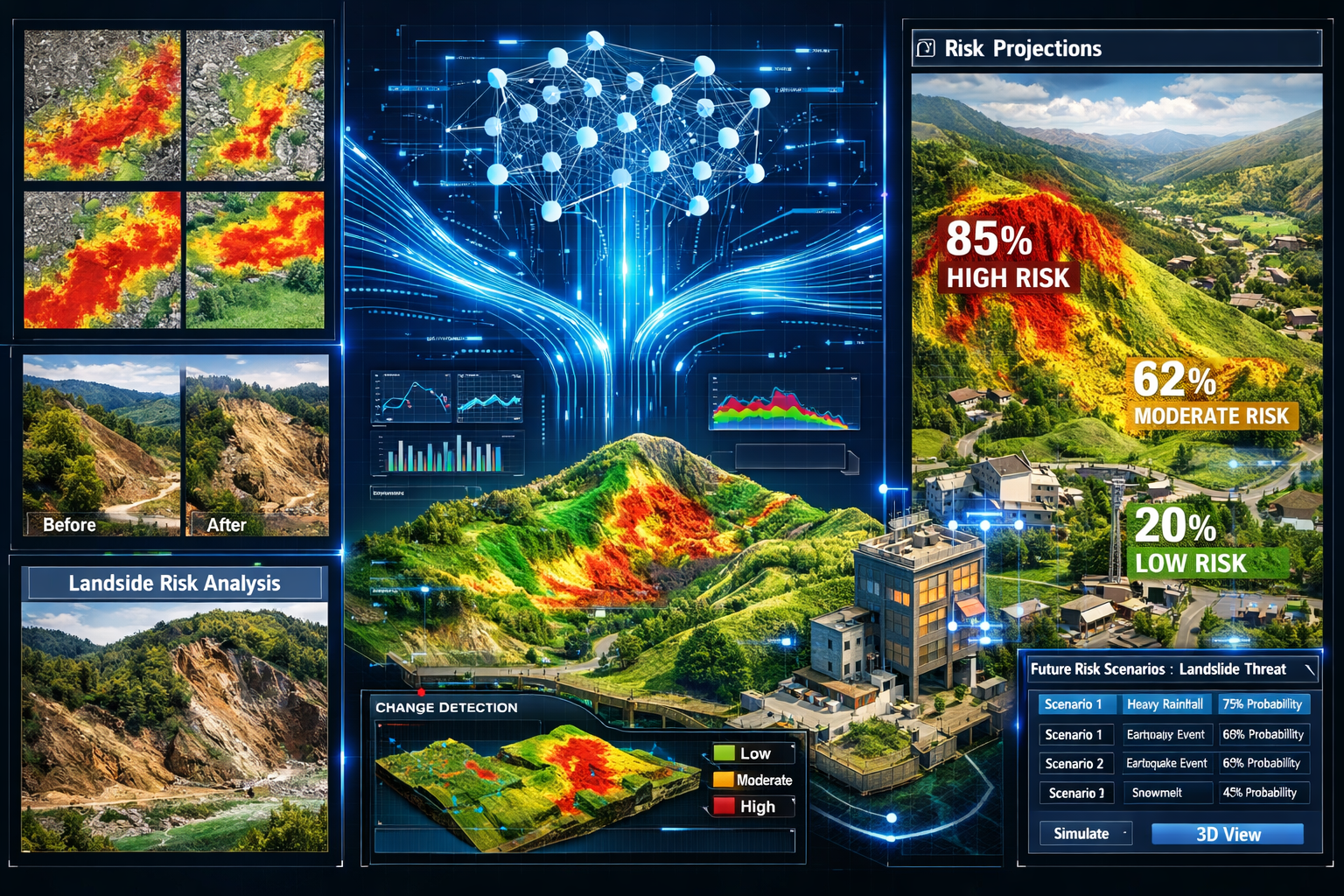
Landslide Susceptibility and Slope Stability Assessment
Landslides represent catastrophic risks that traditional surveying methods struggle to predict accurately. Machine learning algorithms change this equation by analyzing subtle indicators that precede slope failures.
AI systems trained on historical landslide data learn to recognize warning signs:
- Micro-elevation changes indicating soil movement
- Vegetation stress patterns visible in multispectral imagery
- Soil moisture variations affecting slope stability
- Geological layer compositions from subsurface analysis
- Historical movement patterns in the same region
Real-time monitoring capabilities now allow continuous assessment of high-risk slopes.[2] Sensors feed data to AI systems that detect changes measured in millimeters, providing early warnings before visible failures occur. This technology proves particularly valuable for infrastructure projects in mountainous or unstable terrain.
The practical applications extend to urban environments as well. Subsidence surveys now incorporate machine learning analysis to predict which structures face elevated risk based on soil conditions, historical settlement patterns, and environmental factors.
Structural Change Detection and Infrastructure Monitoring
Buildings and infrastructure don't remain static. They settle, shift, and deteriorate over time. Detecting these changes early prevents catastrophic failures and reduces maintenance costs.
Machine learning excels at comparing survey data across time periods, identifying changes that human analysts might miss. AI algorithms process:
Baseline Surveys 📸
Initial comprehensive scans establish reference conditions for structures and terrain. These baselines include millions of data points capturing every detail of the surveyed area.
Periodic Monitoring Scans 🔍
Regular surveys capture current conditions. The frequency depends on risk levels—monthly for critical infrastructure, annually for stable structures.
Automated Change Detection 🚨
AI systems compare new scans against baselines, automatically flagging any deviations. The algorithms distinguish between normal variations (seasonal vegetation changes, temporary objects) and concerning structural movements.
Trend Analysis and Prediction 📈
Machine learning doesn't just identify current changes—it predicts future developments. If a structure shows gradual settlement, AI projects when critical thresholds might be reached, enabling proactive intervention.
This capability transforms how professionals approach structural surveys, moving from reactive assessments to predictive maintenance strategies.
Automating Survey Analysis: From Data Collection to Deliverable Reports
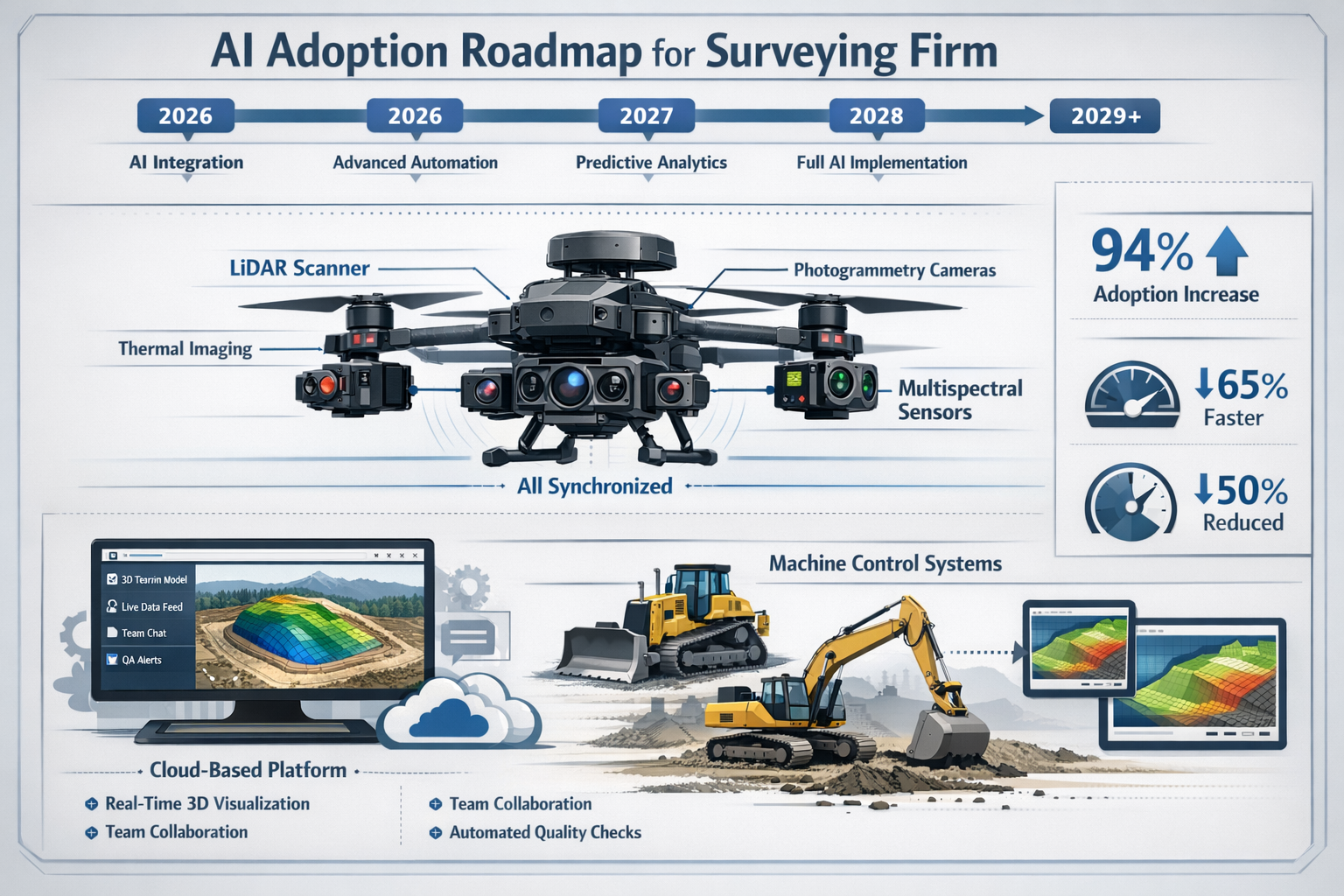
Multi-Sensor Drone Systems and Autonomous Data Capture
The physical process of data collection has transformed dramatically. Multi-sensor drone systems with synchronized sensor arrays now capture data that previously required multiple site visits in a single flight.[1] These sophisticated platforms integrate:
- LiDAR sensors for precise elevation mapping
- High-resolution photogrammetry cameras for visual documentation
- Multispectral sensors detecting vegetation health and moisture
- Thermal imaging cameras identifying heat signatures and insulation issues
What makes these systems truly revolutionary isn't just the sensors themselves—it's the AI-powered autonomous operation. Surveyors plan flight paths using predictive modeling, and drones automatically adjust altitude, angle, and sensor selection for optimal readings.[1]
Consider a complex site with varying terrain, structures, and vegetation. Traditional manual operation would require the pilot to constantly adjust settings and flight parameters. AI systems handle these adjustments automatically:
- Terrain-following algorithms maintain optimal sensor distance over uneven ground
- Obstacle avoidance prevents collisions while maximizing data coverage
- Lighting compensation adjusts camera settings for varying conditions
- Sensor synchronization ensures all data streams align perfectly
For specialized applications like roof surveys, autonomous drones capture comprehensive data including thermal anomalies, structural defects, and drainage issues in a fraction of the time required for manual inspection.
Automated Feature Extraction and Classification
Once collected, raw survey data requires organization and interpretation. This stage traditionally consumed the majority of project timelines. Machine learning algorithms dramatically accelerate data analysis, reducing post-processing timelines from weeks to hours or even minutes.[4]
AI-powered workflows automatically:
Detect Assets and Infrastructure 🏗️
Algorithms trained on infrastructure datasets identify utilities, buildings, roads, and other constructed features. The systems classify each element by type, creating organized inventories without manual tagging.
Identify Defects and Anomalies 🔧
Machine learning recognizes patterns indicating problems: cracks in pavement, vegetation encroachment, structural damage, or drainage issues. The AI flags these concerns for human review, ensuring nothing gets overlooked.
Classify Terrain and Vegetation 🌳
Natural features require classification for comprehensive site analysis. AI systems distinguish between vegetation types, soil categories, water features, and terrain characteristics with greater consistency than manual methods.[4]
Generate Surface Models 🗺️
From point cloud data, algorithms automatically create digital elevation models, contour maps, and 3D surface representations. What once required skilled technicians working for days now happens automatically in minutes.
Real-Time 3D Digital Twins and Interactive Visualization
Perhaps the most transformative development in AI and Machine Learning in Land Surveying: Predicting Risks and Automating Analysis in 2026 is the emergence of real-time 3D digital twins.[1] These interactive models allow developers, engineers, and planners to visualize land behavior under various conditions:
Slope Erosion Projections 🌊
AI models simulate how slopes will erode under different rainfall scenarios, helping designers plan effective drainage and stabilization measures.
Water Flow Simulations 💧
Digital twins show exactly how water moves across terrain during storms, identifying potential flooding areas and optimal drainage paths.
Vegetation Pattern Changes 🌿
Machine learning predicts how vegetation will develop over time, informing landscaping decisions and environmental impact assessments.
Infrastructure Stress Testing 🏢
Virtual models allow engineers to test how structures will respond to various loads, settlements, and environmental conditions before construction begins.
These capabilities extend beyond visualization—they enable evidence-based decision-making that reduces project risks and optimizes designs. Stakeholders can explore scenarios interactively, understanding implications that static reports cannot convey.
Cloud-Based Collaboration and Automated Reporting
The delivery of survey results has evolved from static PDF reports to dynamic, interactive platforms. Cloud-based platforms have replaced static document delivery, now enabling instant file sharing, 3D browser visualization, real-time revision syncing, and integrated communication with engineers and architects.[1]
Modern AI-enhanced surveying workflows include:
Automated Report Generation 📝
Machine learning systems compile findings into comprehensive reports, automatically populating templates with relevant data, images, and analysis. The AI selects the most relevant information for each stakeholder, creating customized deliverables.
Interactive 3D Viewers 🖥️
Clients access survey data through web browsers, exploring 3D models, toggling data layers, and measuring distances without specialized software.
Real-Time Collaboration Tools 👥
Teams comment directly on 3D models, marking areas of concern and discussing solutions. Changes sync instantly across all users, eliminating version control issues.
Automated Quality Assurance ✅
AI systems review reports before delivery, checking for inconsistencies, missing data, and potential errors. This additional layer of quality control catches issues that human reviewers might miss.
For firms offering comprehensive services including dilapidation surveys and expert witness reports, these automated systems ensure consistent quality across all project types.
Implementation Guide: Adopting AI in Surveying Practice
Current Adoption Rates and Industry Trends
The surveying industry's embrace of AI has accelerated dramatically. 94% of surveying professionals from early-adopter firms report plans to increase AI usage in 2026, reflecting rapid expansion beyond the initial 27% adoption rate of the surveying sector.[6] This gap between early adopters and the broader industry creates both opportunities and challenges.
As of the February 1, 2026 industry update, digital transformation is accelerating with pressure to deliver faster, more accurate results.[5] Clients increasingly expect AI-enhanced deliverables, and firms without these capabilities risk losing competitive advantage.
Several factors drive this adoption surge:
- Decreased technology costs making AI tools accessible to smaller firms
- Client demand for faster turnaround times and predictive insights
- Competitive pressure from firms already leveraging AI capabilities
- Improved accuracy reducing liability and rework costs
- Labor shortages making automation essential for maintaining capacity
Essential AI Tools and Technologies for Surveying Firms
Implementing AI doesn't require massive upfront investment. Surveying firms can adopt these technologies incrementally:
Entry-Level AI Integration 💼
- Cloud-based processing platforms with built-in AI classification
- Automated point cloud cleaning and noise reduction
- Basic feature recognition for common survey elements
- Template-based automated reporting tools
Intermediate AI Capabilities 📊
- Multi-sensor drone systems with autonomous flight planning
- Machine learning-based change detection comparing survey periods
- Predictive risk modeling for flooding and slope stability
- Real-time quality control and anomaly detection
Advanced AI Implementation 🚀
- Custom-trained neural networks for specialized applications
- Real-time digital twin environments with simulation capabilities
- Integrated AI across entire workflow from capture to delivery
- Predictive maintenance systems for equipment and infrastructure
Training Requirements and Skill Development
Successful AI adoption requires more than purchasing software—it demands skill development and cultural change. Surveying professionals need new competencies:
Technical Skills 🔧
- Understanding machine learning concepts and limitations
- Operating AI-powered software and interpreting results
- Managing cloud-based workflows and collaboration platforms
- Troubleshooting AI systems when unexpected results occur
Analytical Skills 🧠
- Evaluating AI-generated insights for accuracy and relevance
- Combining AI analysis with professional judgment
- Communicating AI-derived findings to non-technical clients
- Understanding when AI recommendations require human verification
Workflow Integration 📋
- Redesigning processes to leverage AI capabilities
- Establishing quality control protocols for AI outputs
- Managing hybrid teams of human professionals and AI systems
- Balancing automation with professional oversight
Many firms partner with technology providers offering training programs, ensuring staff develop necessary skills while implementing new systems.
Quality Control and Professional Standards
While AI provides tremendous benefits, professional judgment remains essential. The Royal Institution of Chartered Surveyors (RICS) and similar professional bodies emphasize that AI tools augment rather than replace surveyor expertise.
Effective quality control protocols for AI-enhanced surveying include:
Validation Procedures ✓
- Manual verification of AI classifications on representative samples
- Cross-checking AI predictions against known conditions
- Independent review of high-risk or critical findings
- Documentation of AI system limitations and confidence levels
Professional Oversight 👨💼
- Licensed surveyors reviewing and approving all AI-generated outputs
- Clear delineation between automated analysis and professional conclusions
- Transparent communication about which findings derive from AI systems
- Maintaining professional liability coverage appropriate for AI-assisted work
Continuous Improvement 📈
- Tracking AI system accuracy over time
- Retraining algorithms when performance degrades
- Incorporating feedback from field verification
- Staying current with evolving AI capabilities and best practices
For firms providing services like specific defect reports or snagging inspections, maintaining rigorous quality standards ensures AI enhancement doesn't compromise professional reliability.
Real-World Applications and Case Studies
Urban Development and Infrastructure Projects
AI-powered surveying transforms large-scale urban development. Consider a recent mixed-use development project where traditional surveying methods would have required:
- 6 weeks for initial topographic survey and processing
- Multiple site visits for different data collection requirements
- Manual analysis of drainage patterns and flood risks
- Separate studies for vegetation, utilities, and structures
With AI and Machine Learning in Land Surveying: Predicting Risks and Automating Analysis in 2026, the same project achieved:
- 3 days for comprehensive multi-sensor data capture
- Single drone flight collecting LiDAR, photogrammetry, and thermal data
- Automated flood risk modeling identifying vulnerable areas
- Integrated analysis producing complete digital twin environment
The AI system identified a previously unrecognized drainage issue that would have caused significant problems during construction. Early detection saved an estimated £200,000 in remediation costs and prevented construction delays.
Environmental Monitoring and Conservation
Conservation projects benefit enormously from AI's pattern recognition capabilities. A recent coastal erosion study demonstrates this value:
Traditional Approach:
- Annual surveys comparing shoreline positions
- Manual measurement of erosion rates
- Estimation of future erosion based on historical averages
- Limited ability to predict storm impacts
AI-Enhanced Approach:
- Monthly automated drone surveys creating detailed 3D models
- Machine learning analysis identifying erosion patterns and acceleration
- Predictive modeling forecasting erosion under various climate scenarios
- Real-time alerts when erosion rates exceed expected ranges
The AI system detected subtle changes in erosion patterns indicating underlying geological instability. This early warning enabled targeted interventions preventing catastrophic cliff collapse that would have threatened nearby structures.
Machine Control and Construction Automation
Machine control systems are becoming standard equipment on modern earthmoving projects, no longer viewed as optional technology but essential infrastructure.[5] This transformation makes accurate and timely spatial data from surveyors increasingly critical.
AI-enhanced surveying supports machine control through:
Real-Time Design Updates 🔄
As-built surveys feed directly into machine control systems, automatically updating target elevations and alignments based on actual conditions rather than original designs.
Automated Quality Verification ✅
AI systems compare completed earthwork against design specifications, instantly identifying areas requiring correction before equipment moves to the next section.
Predictive Scheduling 📅
Machine learning analyzes progress rates and conditions, predicting when specific areas will be ready for subsequent construction phases and optimizing equipment deployment.
Safety Monitoring 🦺
Continuous surveying combined with AI analysis detects unstable slopes, excessive vibrations, or other hazardous conditions, triggering automatic equipment shutdown when necessary.
Challenges and Limitations of AI in Surveying
Data Quality and Algorithm Training Requirements
AI systems are only as good as their training data. Machine learning algorithms require extensive, high-quality datasets to learn accurate patterns. Poor training data produces unreliable results, potentially worse than no AI assistance at all.
Key challenges include:
Dataset Bias ⚠️
If training data comes predominantly from one region or terrain type, the AI may perform poorly in different environments. A system trained on urban surveys might struggle with rural agricultural land.
Rare Event Recognition 🔍
AI excels at identifying common patterns but may miss unusual conditions. Unique geological features or unprecedented structural failures might not trigger appropriate alerts if the training dataset lacks similar examples.
Continuous Retraining Needs 🔄
As conditions change—new construction methods, different materials, evolving environmental patterns—AI systems require retraining to maintain accuracy. This demands ongoing investment and expertise.
Professional Liability and Ethical Considerations
The integration of AI into professional surveying practice raises important liability questions:
Who bears responsibility when AI systems make errors? The surveyor who relied on the analysis? The software developer? The firm that trained the algorithm?
Current professional standards maintain that licensed surveyors remain ultimately responsible for all work bearing their seal, regardless of AI involvement. This means surveyors must:
- Understand AI system limitations and appropriate use cases
- Verify AI-generated conclusions through professional judgment
- Clearly document which aspects of work involved AI analysis
- Maintain competence to perform surveys without AI assistance
Ethical considerations also emerge around AI transparency. Clients deserve to know when AI systems contribute to their survey results, what confidence levels apply to different findings, and what limitations exist in the analysis.
Technology Access and Digital Divide
While AI costs have decreased, significant investment remains necessary for comprehensive implementation. This creates disparities between large firms with substantial technology budgets and smaller practices operating on tighter margins.
The digital divide manifests in several ways:
Equipment Costs 💰
Multi-sensor drone systems, high-performance computing infrastructure, and specialized software represent substantial capital investments beyond many small firms' reach.
Training and Expertise 🎓
Developing staff competence in AI technologies requires time and resources. Smaller firms may struggle to provide adequate training while maintaining billable capacity.
Competitive Disadvantage 📉
Firms without AI capabilities increasingly struggle to compete on turnaround time, pricing, and service offerings against AI-equipped competitors.
Industry associations and technology providers are working to address these disparities through equipment sharing programs, cloud-based services reducing upfront costs, and collaborative training initiatives.
The Future of AI and Machine Learning in Land Surveying Beyond 2026
Emerging Technologies on the Horizon
The rapid evolution of AI and Machine Learning in Land Surveying: Predicting Risks and Automating Analysis in 2026 shows no signs of slowing. Several emerging technologies promise further transformation:
Quantum Computing Applications ⚛️
Quantum computers could process survey datasets orders of magnitude faster than current systems, enabling real-time analysis of entire regions rather than individual sites.
Advanced Sensor Fusion 🔬
Next-generation systems will integrate even more data sources—ground-penetrating radar, atmospheric sensors, acoustic monitoring—creating unprecedented comprehensive site understanding.
Augmented Reality Field Tools 🥽
Surveyors will wear AR glasses displaying AI-generated insights overlaid on real-world views, seeing predicted flood zones, structural stress points, and subsurface utilities while walking sites.
Autonomous Ground Vehicles 🤖
Self-driving survey robots will complement drone systems, automatically traversing sites to collect ground-level data, set control points, and verify AI-generated findings.
Integration with Smart Cities and IoT Networks
Urban environments are becoming sensor-rich ecosystems. Smart city infrastructure generates continuous streams of data that AI-enhanced surveying will increasingly leverage:
- Traffic flow patterns informing site access planning
- Utility consumption data revealing infrastructure capacity
- Environmental sensors providing real-time air quality and noise measurements
- Structural health monitoring from building-integrated sensors
AI systems will synthesize these diverse data streams with traditional survey information, creating comprehensive digital representations of urban environments that update continuously rather than requiring periodic surveys.
Regulatory Evolution and Professional Standards
Professional bodies and regulatory agencies are actively developing frameworks for AI in surveying. Expected developments include:
AI Competency Requirements 📜
Professional licensing may soon require demonstrated competence in AI technologies, ensuring all practicing surveyors understand these tools' capabilities and limitations.
Standardized Validation Protocols ✓
Industry-wide standards will emerge for validating AI system accuracy, establishing minimum performance requirements for different applications.
Enhanced Disclosure Requirements 📋
Regulations may mandate specific disclosures about AI involvement in survey work, including algorithm types, confidence levels, and validation procedures.
Liability Framework Clarification ⚖️
Legal precedents and regulatory guidance will clarify responsibility allocation when AI systems contribute to professional work, providing clearer liability frameworks.
Practical Steps for Surveyors Adopting AI Technologies
Starting Small: Pilot Projects and Incremental Implementation
Firms new to AI should avoid attempting comprehensive transformation overnight. Successful adoption follows incremental approaches:
Phase 1: Automated Data Processing (Months 1-3)
- Implement cloud-based platforms with built-in AI classification
- Start with automated point cloud cleaning on non-critical projects
- Compare AI outputs against traditional manual processing
- Develop confidence in technology reliability
Phase 2: Feature Recognition (Months 4-6)
- Introduce AI-powered feature extraction for common elements
- Use automated classification for vegetation, terrain, and structures
- Maintain manual verification but reduce processing time
- Expand to more complex projects as confidence grows
Phase 3: Predictive Analysis (Months 7-12)
- Implement flood risk modeling and slope stability assessment
- Begin using digital twin environments for client presentations
- Develop custom AI models for firm-specific applications
- Integrate AI throughout workflow from capture to delivery
This phased approach allows staff to develop skills gradually, builds organizational confidence, and demonstrates value before major investments.
Building Strategic Technology Partnerships
Few surveying firms possess in-house expertise to develop custom AI solutions. Strategic partnerships provide access to cutting-edge capabilities:
Software Vendors 💻
Partner with established geospatial software companies offering AI-enhanced platforms. These relationships provide ongoing updates, training, and technical support.
Academic Institutions 🎓
Collaborate with universities researching AI applications in surveying. These partnerships offer access to emerging technologies and potential talent recruitment.
Industry Consortiums 🤝
Join collaborative groups sharing AI development costs and best practices. Pooled resources enable smaller firms to access capabilities otherwise unavailable.
Technology Consultants 👨💻
Engage specialists who can assess firm-specific needs, recommend appropriate solutions, and guide implementation without long-term overhead.
Measuring ROI and Performance Metrics
Successful AI adoption requires demonstrating value. Key performance indicators help quantify benefits:
| Metric | Traditional Approach | AI-Enhanced Approach | Improvement |
|---|---|---|---|
| Data Processing Time | 5-10 days | 4-8 hours | 90%+ reduction |
| Feature Classification Accuracy | 85-90% | 95-98% | 5-13% improvement |
| Anomaly Detection Rate | 60-70% | 85-95% | 25-35% improvement |
| Client Turnaround Time | 2-3 weeks | 3-5 days | 75%+ reduction |
| Rework/Correction Costs | 5-8% of revenue | 1-3% of revenue | 50-70% reduction |
Beyond quantitative metrics, qualitative benefits include:
- Enhanced client satisfaction through faster delivery and interactive deliverables
- Competitive differentiation offering capabilities competitors lack
- Staff retention by providing cutting-edge tools and interesting work
- Risk reduction through improved accuracy and predictive insights
Conclusion
AI and Machine Learning in Land Surveying: Predicting Risks and Automating Analysis in 2026 represents far more than technological novelty—it fundamentally transforms how surveying professionals work, the value they deliver, and their role in protecting communities and infrastructure. The industry has moved decisively beyond experimental phases into standard practice, with AI systems now embedded into core surveying workflows.[1]
The evidence is compelling: processing times reduced from weeks to hours, predictive capabilities identifying risks before they become catastrophic, and automated analysis maintaining consistency impossible through manual methods. With 94% of early-adopter firms planning to increase AI usage,[6] the trajectory is clear—AI integration will soon separate industry leaders from those struggling to remain relevant.
Yet technology alone doesn't guarantee success. The most effective implementations balance AI capabilities with professional judgment, using machine learning to handle repetitive analysis while freeing surveyors to focus on interpretation, client relationships, and complex problem-solving that requires human expertise.
Actionable Next Steps
For surveying professionals ready to embrace AI capabilities:
-
Assess current workflows identifying tasks most suitable for AI automation—typically repetitive data processing and classification work consuming significant time without requiring professional judgment.
-
Start with pilot projects on non-critical work, building confidence and demonstrating value before expanding AI integration across all operations.
-
Invest in training ensuring staff develop necessary skills to operate AI systems effectively and understand their limitations.
-
Establish quality control protocols maintaining professional standards while leveraging AI efficiency gains.
-
Engage with technology partners accessing expertise and capabilities beyond most firms' in-house resources.
-
Monitor industry developments staying current with rapidly evolving AI capabilities, regulatory frameworks, and professional standards.
-
Communicate value to clients explaining how AI-enhanced services provide faster turnaround, greater accuracy, and predictive insights unavailable through traditional methods.
The surveying profession stands at an inflection point. Those who embrace AI and Machine Learning in Land Surveying: Predicting Risks and Automating Analysis in 2026 position themselves to lead the industry forward, delivering unprecedented value while maintaining the professional standards that have always defined quality surveying practice.
For property owners, developers, and construction professionals, partnering with chartered surveyors who leverage these advanced capabilities ensures projects benefit from the latest technological innovations while maintaining the professional oversight essential for reliable results.
The future of land surveying isn't about replacing human expertise with algorithms—it's about augmenting professional judgment with computational power, enabling surveyors to work smarter, deliver faster, and protect communities more effectively than ever before.
References
[1] Future Land Surveying 2026 – https://haller-blanchard.com/future-land-surveying-2026/
[2] The Future Of Land Surveying Technology And Upcoming Trends In 2026 – https://metricop.com/blogs/land-surveying/the-future-of-land-surveying-technology-and-upcoming-trends-in-2026
[3] Watch – https://www.youtube.com/watch?v=mDFbLrhWNdI
[4] How Is Ai And Machine Learning Transforming Data Collection Operations In 2026 – https://flyguys.com/how-is-ai-and-machine-learning-transforming-data-collection-operations-in-2026/
[5] Doubling Down On Digital – https://amerisurv.com/2026/02/01/doubling-down-on-digital/
[6] Architecture Engineering Construction Sector Slow To Adapt Ai Survey Shows – https://www.asce.org/publications-and-news/civil-engineering-source/article/2025/12/18/architecture-engineering-construction-sector-slow-to-adapt-ai-survey-shows