"

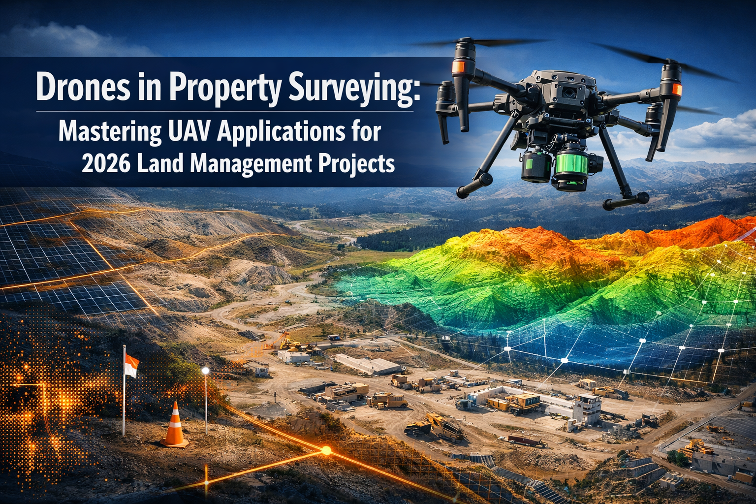
The surveying industry stands at a revolutionary crossroads in 2026. What once required weeks of manual labor, expensive equipment, and significant safety risks can now be accomplished in mere hours with affordable drone technology. Drones in Property Surveying: Mastering UAV Applications for 2026 Land Management Projects represents more than just a technological advancement—it's a complete transformation of how professionals approach land management, topographic mapping, and property assessment. With over 70 percent of US construction projects now utilizing drone surveys[4], the question is no longer whether to adopt UAV technology, but how to master it effectively.
The drone mapping market has exploded to exceed $6.5 billion in 2026[4], driven by surveyors who recognize that affordable drones equipped with LiDAR sensors and high-resolution cameras deliver centimeter-level accuracy at a fraction of traditional costs. This guide explores the practical applications, cost-saving strategies, and essential tips for surveyors ready to embrace this game-changing technology.
Key Takeaways
✅ Market Dominance: Over 70% of construction projects now use drone surveys, with the market exceeding $6.5 billion in 2026[4]
✅ Dramatic Efficiency Gains: Drone surveys reduce timeframes from weeks to hours while cutting operational costs by up to 65%[2]
✅ Multi-Sensor Revolution: Modern UAVs carry synchronized LiDAR, photogrammetry, thermal, and multispectral sensors for comprehensive data capture in single flights[1]
✅ Centimeter-Level Accuracy: High-resolution drone cameras and advanced sensors deliver precision comparable to traditional methods[3]
✅ Enhanced Safety: UAV technology eliminates surveyor exposure to hazardous terrain, busy roads, and dangerous environments[2]
Understanding the UAV Revolution in Property Surveying
The Shift from Traditional to Drone-Based Surveying Methods
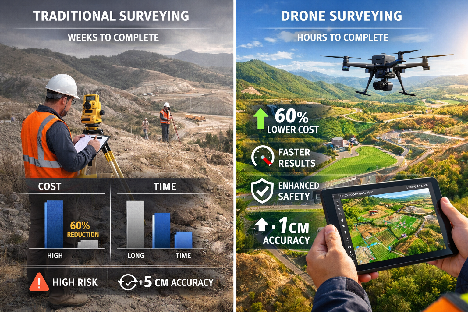
Traditional property surveying has relied on ground-based techniques for centuries. Surveyors with theodolites, total stations, and GPS equipment would spend days or weeks traversing properties, manually collecting data points, and facing numerous challenges including difficult terrain, weather delays, and safety hazards.
Drones in Property Surveying: Mastering UAV Applications for 2026 Land Management Projects fundamentally changes this paradigm. Modern UAV systems complete the same work in hours rather than days[2], capturing thousands of data points per second while surveyors remain safely positioned at ground level. This transformation isn't just about speed—it's about accessing previously unreachable areas, improving data quality, and dramatically reducing project costs.
The technology has matured to the point where affordable drones now deliver professional-grade results. Entry-level survey drones equipped with high-resolution cameras start around $1,500, while advanced systems with integrated LiDAR sensors range from $15,000 to $50,000—still significantly less expensive than traditional surveying equipment when considering the reduced labor costs and time savings.
Why 2026 Marks a Turning Point for UAV Adoption
Several factors converge in 2026 to make this the optimal time for surveyors to adopt drone technology:
🚁 Regulatory Advancement: New frameworks enable longer flight times and beyond-visual-line-of-sight (BVLOS) operations[5][6], expanding survey capabilities and geographic reach without constant pilot repositioning.
🚁 AI-Driven Analytics: Aerial survey companies now harness artificial intelligence for real-time data processing, with autonomous drone fleets streaming site information directly to project dashboards[4].
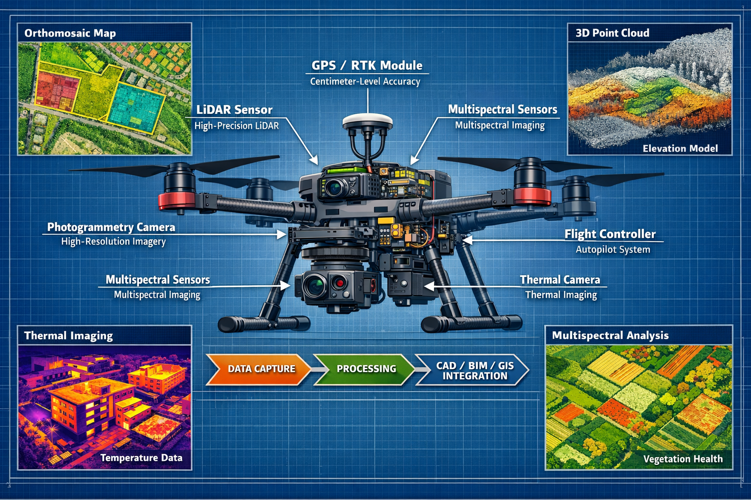
🚁 Sensor Integration: Multi-sensor autonomous systems carry synchronized arrays—LiDAR, photogrammetry cameras, multispectral sensors, and thermal imaging units working together[1]—eliminating the need for multiple site visits.
🚁 Predictive Flight Planning: Drones feature autonomous capabilities with predictive modeling for flight path planning, automatically adjusting altitude, angle, and sensor selection to achieve optimal readings[1].
For property professionals conducting structural surveys or roof inspections, these advancements mean more comprehensive data collection with less disruption to property owners.
Core Technologies Powering Drones in Property Surveying
LiDAR Systems: Penetrating Vegetation for Accurate Terrain Mapping
Light Detection and Ranging (LiDAR) technology represents one of the most significant advances in drone surveying capabilities. Unlike traditional photogrammetry, which relies on visible surfaces, LiDAR uses laser pulses to penetrate vegetation canopy and create detailed three-dimensional representations of the ground surface beneath.
For land management projects involving forested areas, overgrown properties, or sites with dense vegetation, LiDAR-equipped drones provide unprecedented accuracy. The technology generates point clouds—collections of millions of individual data points—that reveal terrain features invisible to standard cameras.
Key LiDAR advantages for property surveying:
- Vegetation penetration: Captures ground surface data beneath tree cover and dense brush
- Elevation accuracy: Delivers centimeter-level precision for topographic mapping
- Feature detection: Identifies subtle terrain variations, drainage patterns, and boundary markers
- All-weather capability: Functions effectively in various lighting conditions, including overcast days
Modern survey-grade drones integrate LiDAR with GPS/RTK (Real-Time Kinematic) positioning systems, ensuring each data point includes precise geographic coordinates. This integration proves essential for boundary surveys and cadastral mapping applications.
High-Resolution Photogrammetry Cameras
While LiDAR excels at terrain mapping, high-resolution photogrammetry cameras capture the visual detail necessary for comprehensive property documentation. These cameras take hundreds or thousands of overlapping images during flight, which specialized software processes into detailed outputs.
Photogrammetry delivers:
| Output Type | Application | Accuracy Level |
|---|---|---|
| Orthomosaic Maps | 2D property mapping with corrected perspective | 1-3 cm ground resolution |
| 3D Models | Volumetric analysis, building documentation | Sub-5 cm accuracy |
| Digital Elevation Models (DEMs) | Topographic analysis, drainage planning | 2-5 cm vertical accuracy |
| Point Clouds | Detailed surface reconstruction | Centimeter-level precision |
For professionals conducting commercial building surveys or dilapidation assessments, photogrammetry provides visual documentation that traditional methods cannot match.
Thermal and Multispectral Imaging for Comprehensive Analysis
Thermal imaging sensors detect infrared radiation, revealing temperature variations across surfaces. This capability proves invaluable for:
- Building envelope analysis: Identifying heat loss, insulation defects, and moisture intrusion
- Roof condition assessment: Detecting membrane failures and water accumulation
- Solar panel inspection: Locating malfunctioning cells and electrical issues
- Vegetation health monitoring: Assessing irrigation effectiveness and plant stress
Multispectral sensors capture data across multiple wavelength bands beyond visible light, enabling analysis of vegetation health, soil conditions, and land use patterns. For agricultural land management and environmental monitoring, multispectral imaging provides insights impossible to obtain through visual inspection alone.
The integration of these diverse sensors into single UAV platforms represents the core advantage of Drones in Property Surveying: Mastering UAV Applications for 2026 Land Management Projects. What previously required separate site visits with different equipment now happens in one comprehensive flight mission.
Practical Applications and Case Studies
Large-Scale Topographic Mapping Projects
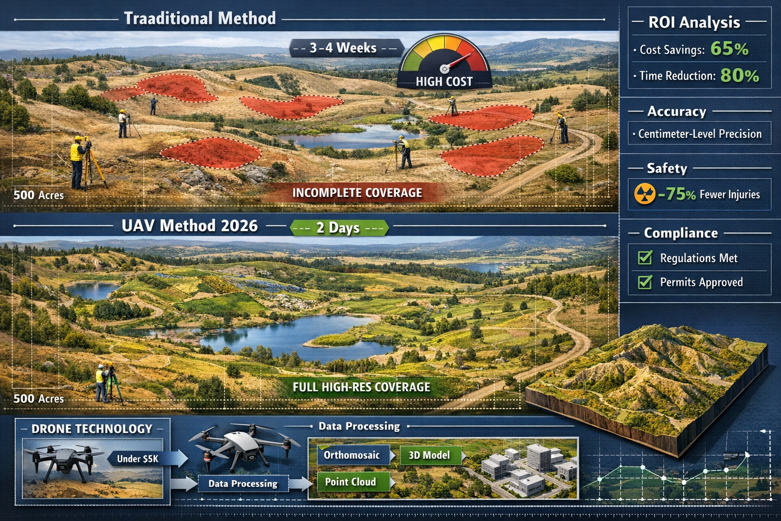
Case Study: 500-Acre Rural Development Site
A land development company needed comprehensive topographic mapping for a 500-acre rural property with varied terrain including hills, valleys, water features, and dense vegetation. Traditional surveying quotes estimated 3-4 weeks of fieldwork with costs exceeding $45,000.
Drone Solution Implementation:
The surveying team deployed a mid-range UAV equipped with both LiDAR and high-resolution RGB camera, completing data capture in just two days of flight operations. The autonomous flight planning system optimized coverage patterns, ensuring complete overlap for accurate photogrammetry processing.
Results achieved:
- ✅ Time reduction: 85% faster than traditional methods (2 days vs. 3-4 weeks)
- ✅ Cost savings: 65% reduction in total project costs ($15,750 vs. $45,000)
- ✅ Enhanced accuracy: Centimeter-level precision across entire property
- ✅ Comprehensive deliverables: Orthomosaic maps, 3D terrain models, contour maps, and volumetric calculations
- ✅ Safety improvement: Zero surveyor exposure to challenging terrain or wildlife encounters
The project delivered detailed cadastral maps with clear identification of property boundaries, drainage systems, vegetation zones, and suitable building areas—all processed and delivered within one week of data capture.
Urban Property Boundary and Cadastral Mapping
Drones are generating sharp orthomosaics and intricate 3D representations for highly precise cadastral maps, even in challenging urban environments[2]. Modern UAV systems identify features like signage, curbs, road indicators, hydrants, and drainage systems with remarkable clarity.
Urban surveying advantages:
🏙️ Access to difficult areas: Drones easily survey rooftops, courtyards, and areas blocked by buildings or fences
🏙️ Traffic safety: Eliminates need for surveyors working near busy roads or in high-traffic zones
🏙️ Neighbor relations: Minimizes disruption to adjacent properties during survey operations
🏙️ Comprehensive documentation: Captures context beyond property boundaries, including nearby structures and infrastructure
For surveyors working on party wall matters or addressing boundary disputes, drone imagery provides objective visual evidence that supports accurate boundary determination and reduces conflicts.
Construction Site Monitoring and Progress Tracking
Over 70 percent of US construction projects now use drone surveys for mapping and monitoring[4], representing a major shift toward reducing manual labor while improving accuracy. Construction managers utilize drones for:
Regular progress documentation: Weekly or monthly flights create visual timelines showing project advancement, helping identify delays and verify contractor work completion.
Volumetric analysis: Automated stockpile measurements track material quantities, reducing waste and preventing theft.
Quality control: High-resolution imagery reveals construction defects, safety violations, and deviations from plans before they become costly problems.
Stakeholder communication: 3D models and flythrough videos provide compelling visual updates for investors, clients, and regulatory agencies.
The time efficiency of drone surveys proves particularly valuable for construction monitoring. Traditional ground-based surveying might require days for large sites, while drones cover the same ground in hours[2], enabling more frequent monitoring without disrupting construction activities.
Roof and Building Envelope Inspections
Drone roof surveys have revolutionized how surveyors assess building conditions. Traditional roof surveys require scaffolding, ladders, or cherry pickers—expensive equipment that poses significant safety risks.
Drone inspection benefits:
- Eliminated fall risks: Surveyors remain safely on the ground
- Faster completion: Complete building envelope assessment in 30-60 minutes
- Superior documentation: High-resolution imagery captures details invisible from ground level
- Thermal analysis: Identifies moisture intrusion, insulation defects, and structural issues
- Cost reduction: Eliminates scaffolding and access equipment rental costs
For commercial properties requiring dilapidation surveys or residential properties needing condition assessments, drone technology provides comprehensive documentation at a fraction of traditional costs.
Cost-Benefit Analysis: ROI of UAV Technology Adoption
Initial Investment Requirements
Understanding the financial commitment required for Drones in Property Surveying: Mastering UAV Applications for 2026 Land Management Projects helps surveyors make informed adoption decisions.
Entry-Level Setup ($2,000 – $8,000):
- Consumer-grade drone with high-resolution camera: $1,500 – $3,000
- Basic photogrammetry software subscription: $150 – $300/month
- Spare batteries and accessories: $300 – $500
- Training and certification: $150 – $300
Professional Setup ($15,000 – $35,000):
- Survey-grade drone with RTK/PPK GPS: $8,000 – $15,000
- Professional photogrammetry and mapping software: $300 – $1,200/month
- LiDAR-equipped system (optional upgrade): $15,000 – $30,000
- Comprehensive training program: $1,000 – $2,000
- Insurance coverage: $1,500 – $3,000/year
Advanced Multi-Sensor Setup ($50,000 – $100,000+):
- Enterprise-grade UAV platform: $25,000 – $50,000
- Integrated LiDAR, thermal, and multispectral sensors: $20,000 – $40,000
- Enterprise software suite with AI analytics: $2,000 – $5,000/month
- Specialized training and certification: $3,000 – $5,000
- Comprehensive insurance and maintenance: $5,000 – $10,000/year
Operational Cost Savings
The return on investment for drone technology becomes apparent quickly when comparing operational expenses:
Traditional surveying costs (500-acre project):
- Field crew (3 surveyors × 20 days): $30,000
- Equipment rental and transportation: $5,000
- Processing and drafting time: $8,000
- Insurance and overhead: $2,000
- Total: $45,000
Drone surveying costs (same project):
- Pilot and assistant (2 days field + 3 days processing): $7,500
- Drone operation and maintenance: $500
- Software processing and analysis: $1,250
- Insurance and overhead: $500
- Total: $9,750
Savings: $35,250 (78% reduction)
These savings compound across multiple projects. A surveying firm completing just 10 comparable projects annually saves over $350,000 in operational costs—easily justifying even the most expensive equipment investments.
Time Efficiency and Project Capacity Increases
Beyond direct cost savings, drone technology enables surveyors to dramatically increase project capacity. The time efficiency gains[2] mean firms can complete more projects with the same staff:
Traditional capacity: 1 surveyor completing 15-20 projects annually
Drone-enhanced capacity: 1 surveyor completing 40-60 projects annually
This 200-300% increase in throughput represents substantial revenue growth potential without proportional increases in labor costs. For firms looking to expand service offerings or enter new markets, drone technology provides the scalability to support growth.
Essential Tips for Surveyors Adopting UAV Technology
Regulatory Compliance and Certification Requirements
Before launching drone surveying operations, surveyors must navigate regulatory requirements that vary by jurisdiction. In 2026, most countries require:
Pilot Certification: Commercial drone operators need specific licenses demonstrating knowledge of airspace regulations, safety procedures, and operational limitations. In the United States, this means obtaining a Part 107 Remote Pilot Certificate from the FAA.
Aircraft Registration: Drones used for commercial purposes must be registered with aviation authorities, displaying registration numbers on the aircraft.
Operational Limitations: Standard regulations typically restrict flights to daylight hours, visual line-of-sight operations, maximum altitudes (typically 400 feet), and minimum distances from airports and populated areas.
BVLOS Operations: New regulatory frameworks in 2026 enable beyond-visual-line-of-sight operations[5][6], but these require additional approvals, waivers, or certifications demonstrating enhanced safety measures.
Insurance Requirements: Professional liability insurance specifically covering drone operations protects against property damage, privacy violations, and data breaches.
Surveyors should consult local aviation authorities and consider working with legal professionals specializing in drone regulations to ensure complete compliance.
Selecting the Right Equipment for Your Survey Needs
Choosing appropriate drone equipment requires careful consideration of typical project requirements:
For boundary and cadastral surveys: Prioritize high-resolution cameras with RTK/PPK GPS for centimeter-level accuracy. Standard photogrammetry capabilities suffice for most applications.
For topographic mapping: LiDAR-equipped systems provide superior results, especially in vegetated areas. The additional investment pays off through reduced processing time and improved accuracy.
For building inspections: Thermal imaging capabilities prove essential for comprehensive condition assessments. Look for drones with interchangeable payloads allowing both visual and thermal sensors.
For construction monitoring: Autonomous flight planning and automated processing workflows maximize efficiency for regular repeat surveys. Consider systems with cloud-based data management for stakeholder access.
For multi-purpose operations: Modular systems accepting various sensor payloads provide flexibility to serve diverse client needs without maintaining multiple drone platforms.
When evaluating specific models, consider:
- ✈️ Flight time: Longer battery life reduces mission interruptions
- ✈️ Wind resistance: Stable flight in challenging conditions ensures consistent data quality
- ✈️ Portability: Compact, foldable designs simplify transportation
- ✈️ Sensor quality: Higher resolution and accuracy justify premium pricing
- ✈️ Software ecosystem: Seamless integration with processing tools streamlines workflows
Software Selection and Data Processing Workflows
Hardware represents only half the equation—Drones in Property Surveying: Mastering UAV Applications for 2026 Land Management Projects requires robust software for transforming raw aerial imagery into actionable deliverables.
Leading photogrammetry platforms include:
- Pix4D: Industry-standard software offering comprehensive processing for orthomosaics, 3D models, and point clouds
- DroneDeploy: Cloud-based platform with intuitive interface and automated processing workflows
- Agisoft Metashape: Professional-grade photogrammetry with advanced control and customization
- Propeller: Specialized for construction and earthworks with volumetric analysis tools
Integration capabilities matter significantly. Modern outputs include orthomosaic maps, 3D models, LiDAR point clouds, thermal imagery, and multispectral datasets, with seamless integration into CAD, BIM, and GIS platforms[3][4] for real-time actionable intelligence.
Recommended workflow:
- Mission planning: Use automated flight planning software to design optimal coverage patterns
- Data capture: Execute autonomous flights with appropriate sensor configurations
- Quality control: Review imagery immediately to identify gaps or issues requiring reflights
- Processing: Upload data to photogrammetry software for automated processing
- Analysis: Extract measurements, create deliverables, and perform specialized analysis
- Integration: Export results to CAD/BIM/GIS platforms for client delivery
- Archiving: Maintain organized data libraries for future reference and comparison
Training and Skill Development Strategies
Successful UAV adoption requires investment in human capital alongside equipment purchases. Effective training strategies include:
Manufacturer training programs: Most professional drone manufacturers offer comprehensive training covering equipment operation, maintenance, and best practices.
Industry associations: Organizations like the Commercial UAV Expo, ASPRS (American Society for Photogrammetry and Remote Sensing), and RICS (Royal Institution of Chartered Surveyors) provide educational resources and networking opportunities.
Online courses: Platforms like Drone Pilot Ground School, UAV Coach, and Coursera offer flexible learning options for busy professionals.
Hands-on practice: Allocate time for pilots to gain experience in controlled environments before undertaking client projects. Practice emergency procedures, manual flight controls, and various sensor operations.
Continuing education: Technology evolves rapidly—commit to ongoing learning about new sensors, software updates, and regulatory changes.
Consider developing internal expertise across multiple team members rather than relying on a single drone specialist. This redundancy ensures project continuity and enables larger operations.
Safety Protocols and Risk Management
Despite eliminating many traditional surveying hazards, drone operations introduce new safety considerations:
Pre-flight procedures:
- ✅ Conduct thorough equipment inspections checking batteries, propellers, sensors, and connections
- ✅ Verify weather conditions meet operational requirements
- ✅ Confirm airspace clearances and identify potential obstacles
- ✅ Establish communication protocols with ground crew
- ✅ Brief all personnel on emergency procedures
Operational safety:
- ✅ Maintain visual observers for enhanced situational awareness
- ✅ Establish safety perimeters keeping unauthorized persons clear of flight operations
- ✅ Monitor battery levels and return-to-home functionality
- ✅ Avoid flying over crowds, vehicles, or occupied structures
- ✅ Respect privacy and property rights of adjacent landowners
Data security:
- ✅ Implement encryption for sensitive survey data
- ✅ Establish secure data transfer and storage protocols
- ✅ Maintain backup systems preventing data loss
- ✅ Comply with privacy regulations regarding aerial imagery
The safety enhancement provided by drones—eliminating risks associated with traditional surveying[2]—only materializes when operators follow rigorous safety protocols and maintain professional standards.
Advanced Applications and Future Developments
AI-Driven Analytics and Automated Feature Detection
Artificial intelligence transforms raw drone data into actionable intelligence with minimal manual intervention. AI-driven analytics[4] now enable:
Automated feature extraction: Machine learning algorithms identify and classify features like buildings, roads, vegetation, water bodies, and infrastructure without manual digitization.
Change detection: Comparing sequential surveys automatically highlights modifications, new construction, erosion, or vegetation changes.
Defect identification: AI analyzes building imagery to detect cracks, corrosion, moisture damage, and structural issues requiring attention.
Predictive maintenance: Pattern recognition identifies early warning signs of infrastructure deterioration before failures occur.
These capabilities dramatically reduce the labor-intensive processing that previously limited drone surveying scalability. What once required days of manual digitization now happens automatically in hours.
Integration with BIM and Digital Twin Technologies
Building Information Modeling (BIM) and digital twin technologies represent the future of property and infrastructure management. Drones provide the real-world data that keeps these digital representations current and accurate.
BIM integration workflows:
- Drone surveys capture as-built conditions of existing structures
- Point cloud data imports directly into BIM software (Revit, ArchiCAD, etc.)
- Automated or semi-automated model generation creates 3D representations
- Regular drone surveys update models reflecting renovations, additions, or deterioration
- Facility managers use current models for maintenance planning and space management
Digital twin applications:
For large properties, campuses, or infrastructure networks, digital twins—virtual replicas synchronized with real-world conditions through continuous data feeds—enable sophisticated management:
- Predictive analytics: Modeling how changes affect systems before implementation
- Energy optimization: Identifying efficiency improvements through thermal analysis
- Asset management: Tracking condition and maintenance schedules for all components
- Emergency planning: Simulating scenarios and optimizing response procedures
The seamless integration into CAD, BIM, and GIS platforms[3][4] positions drone surveying as the essential data source for next-generation property management.
Autonomous Drone Fleets and Continuous Monitoring
The evolution toward autonomous drone fleets streaming site data in real time to project dashboards[4] represents the next frontier in land management technology.
Fleet capabilities emerging in 2026:
🤖 Automated scheduling: Drones autonomously execute regular monitoring flights without human intervention
🤖 Coordinated operations: Multiple drones work simultaneously, dividing large areas for faster coverage
🤖 Adaptive intelligence: Systems adjust flight parameters based on weather, lighting, and data quality requirements
🤖 Continuous monitoring: Permanent or semi-permanent drone installations provide ongoing surveillance for critical infrastructure
🤖 Real-time alerts: Immediate notification when automated analysis detects issues requiring attention
For construction sites, mining operations, agricultural lands, and infrastructure networks, continuous monitoring provides unprecedented visibility into changing conditions. When considering what survey you need, the ability to conduct frequent drone surveys at minimal incremental cost makes regular monitoring economically viable for projects where it was previously impractical.
Emerging Sensor Technologies
Innovation in sensor technology continues expanding drone surveying capabilities:
Hyperspectral imaging: Capturing data across dozens or hundreds of narrow wavelength bands enables detailed material identification and analysis beyond current multispectral capabilities.
Ground-penetrating radar: Airborne GPR systems detect subsurface features like buried utilities, archaeological remains, and geological structures.
Gas detection sensors: Environmental monitoring applications benefit from sensors detecting methane, carbon dioxide, and other gases.
Acoustic sensors: Sound-based detection systems identify equipment malfunctions, wildlife, or unauthorized activities.
As these technologies mature and costs decrease, they'll integrate into standard surveying workflows, further expanding the value proposition of Drones in Property Surveying: Mastering UAV Applications for 2026 Land Management Projects.
Overcoming Common Challenges and Limitations
Weather and Environmental Constraints
Despite technological advances, drones remain subject to environmental limitations:
Wind sensitivity: Most survey drones operate safely in winds up to 20-25 mph, though higher-end systems tolerate stronger conditions. High winds affect image quality and positioning accuracy.
Precipitation: Rain damages electronic components and obscures camera lenses. Most operations cease during precipitation.
Temperature extremes: Cold weather reduces battery performance, while extreme heat affects electronics and flight stability.
Lighting conditions: Photogrammetry requires adequate lighting, limiting operations during early morning, late evening, or heavily overcast conditions. LiDAR systems function regardless of lighting but still require clear atmospheric conditions.
Mitigation strategies:
- Schedule flights during optimal weather windows
- Maintain weather monitoring tools and forecasting services
- Keep backup project dates for weather-delayed missions
- Invest in weather-resistant equipment for challenging environments
- Use LiDAR for projects where lighting limitations pose problems
Privacy and Property Rights Considerations
Aerial surveying raises legitimate privacy concerns requiring careful navigation:
Notification protocols: Inform adjacent property owners before conducting surveys near boundaries. Professional courtesy prevents conflicts and demonstrates respect for privacy.
Data handling: Implement policies governing what imagery is captured, how it's stored, who accesses it, and when it's deleted. Blur or redact sensitive areas in deliverables.
Regulatory compliance: Understand local privacy laws and aviation regulations governing aerial imagery and data collection.
Consent documentation: Obtain written permission when surveying private property, clearly explaining what data will be collected and how it will be used.
Professional standards: Follow industry best practices and ethical guidelines established by professional organizations like RICS.
Proactive privacy management prevents legal complications and maintains professional reputation.
Accuracy Limitations and Quality Control
While drones equipped with high-resolution cameras deliver centimeter-level accuracy[3], results depend on sensor quality, altitude, and ground conditions. Understanding these limitations ensures appropriate application:
Factors affecting accuracy:
- Ground control points: Surveyed reference markers dramatically improve absolute accuracy
- Flight altitude: Lower flights capture more detail but cover less area per flight
- Image overlap: Higher overlap percentages (75-85%) improve processing accuracy
- GPS quality: RTK/PPK systems provide superior positioning compared to standard GPS
- Ground surface characteristics: Reflective, transparent, or moving surfaces challenge photogrammetry
- Vegetation density: Heavy canopy limits photogrammetry effectiveness (LiDAR performs better)
Quality control procedures:
- Establish ground control points using traditional surveying methods
- Verify drone GPS calibration before each mission
- Review imagery quality immediately after flights
- Process data with appropriate software settings and parameters
- Validate outputs against ground control measurements
- Document accuracy assessments in deliverables
- Maintain equipment calibration and regular maintenance schedules
Professional surveyors understand when drone technology provides optimal results and when traditional methods or hybrid approaches deliver superior outcomes.
Conclusion: Embracing the Future of Property Surveying
Drones in Property Surveying: Mastering UAV Applications for 2026 Land Management Projects represents far more than adopting new equipment—it's embracing a fundamental transformation in how surveying professionals serve clients, manage projects, and build sustainable practices. The convergence of affordable hardware, sophisticated sensors, AI-driven analytics, and supportive regulatory frameworks creates an unprecedented opportunity for surveyors ready to invest in this technology.
The compelling statistics speak for themselves: over 70 percent of construction projects now use drone surveys[4], the market exceeds $6.5 billion[4], and operational cost reductions of 60-80% are routinely achieved. These aren't future projections—they're current realities transforming the industry in 2026.
For surveying professionals, the path forward involves strategic decisions about equipment investment, skill development, and service expansion. Success requires:
🎯 Strategic planning: Assess your typical project portfolio and identify where drone technology delivers maximum value. Start with applications offering clear ROI before expanding to specialized niches.
🎯 Quality training: Invest in comprehensive education covering piloting skills, regulatory compliance, data processing, and safety protocols. Technology only delivers value when operators possess the expertise to use it effectively.
🎯 Client education: Help clients understand the advantages of drone surveying—faster turnaround, comprehensive documentation, enhanced safety, and reduced costs. Position UAV services as premium offerings that deliver superior value.
🎯 Continuous improvement: Technology evolves rapidly. Commit to ongoing learning, equipment upgrades, and process refinement to maintain competitive advantages.
🎯 Professional standards: Maintain the highest ethical and quality standards. The accessibility of consumer drones means many operators enter the market without professional surveying backgrounds. Differentiate through expertise, accuracy, and comprehensive service.
Actionable Next Steps
Ready to master UAV applications for your land management projects? Take these concrete steps:
- Assess your readiness: Evaluate current projects, identify drone-suitable applications, and calculate potential ROI
- Research equipment options: Compare systems matching your budget and project requirements
- Obtain necessary certifications: Complete pilot training and regulatory compliance requirements
- Start small: Begin with straightforward projects building skills and confidence before tackling complex surveys
- Develop workflows: Establish standardized procedures for mission planning, data capture, processing, and delivery
- Measure results: Track time savings, cost reductions, and client satisfaction to refine your approach
- Expand capabilities: Gradually add advanced sensors, software, and techniques as expertise grows
The future of property surveying is aerial, autonomous, and data-rich. Professionals who master these technologies position themselves at the forefront of an industry transformation that shows no signs of slowing. Whether you're conducting boundary surveys, structural assessments, or comprehensive land management projects, drone technology offers tools to work smarter, safer, and more profitably.
The question isn't whether to adopt UAV technology—it's how quickly you can integrate it into your practice to serve clients better while building a more sustainable, scalable surveying business for the future.
References
[1] Future Land Surveying 2026 – https://haller-blanchard.com/future-land-surveying-2026/
[2] Drone Surveying – https://uavcoach.com/drone-surveying/
[3] Advancing Surveying With Drone Technology – https://www.unmannedsystemstechnology.com/feature/advancing-surveying-with-drone-technology/
[4] Aerial Survey Companies – https://www.extremeaerialproductions.com/post/aerial-survey-companies
[5] Three Things Geospatial Professionals Should Know About The Drone Industry In 2026 – https://www.geoweeknews.com/news/three-things-geospatial-professionals-should-know-about-the-drone-industry-in-2026
[6] Watch – https://www.youtube.com/watch?v=CSTodaZb4Vc
[7] Webinar The State Of Drone Surveying A Strategic Briefing For 2026 – https://www.aerotas.com/blog/webinar-the-state-of-drone-surveying-a-strategic-briefing-for-2026
[8] Watch – https://www.youtube.com/watch?v=K4EVh9gH_qM