The landscape of property development is changing rapidly. Imagine standing on a vacant lot, yet seeing invisible layers of information—zoning restrictions, underground utilities, soil composition, flood zones, and property boundaries—all displayed in real-time on a tablet screen. This isn't science fiction; it's the reality of GIS integration in property surveying: overlaying data for smarter land use decisions in 2026. As land becomes increasingly scarce and development regulations grow more complex, surveyors who harness Geographic Information Systems (GIS) technology gain a decisive advantage in delivering comprehensive, accurate, and actionable insights to clients.
The convergence of traditional surveying precision with modern GIS capabilities has fundamentally transformed how professionals approach land use planning, development feasibility studies, and regulatory compliance. By centralizing disparate data sources into unified spatial platforms, surveyors can now visualize relationships between physical features, legal boundaries, environmental constraints, and infrastructure networks that were previously invisible or required days of manual research to uncover.
Key Takeaways
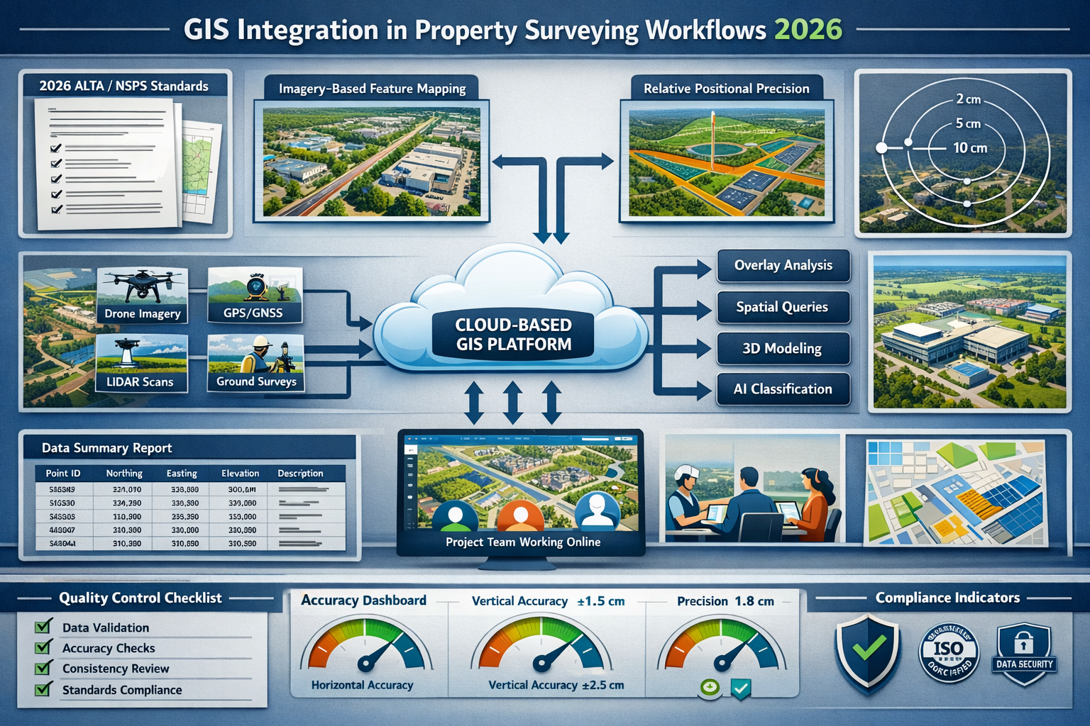
- GIS integration centralizes critical data layers including zoning regulations, property boundaries, utility networks, and environmental constraints into a single visual platform for comprehensive analysis
- The 2026 ALTA/NSPS standards now explicitly support emerging technologies like drones, AI, and imagery-based feature mapping, providing regulatory flexibility for modern surveying workflows[1][3]
- Real-time 3D digital twins and cloud-based collaboration enable instant visualization of land behavior, continuous data updates, and seamless coordination between surveyors, engineers, architects, and clients[2]
- AI-powered automation significantly reduces manual data processing time by automatically classifying terrain, identifying markers, flagging anomalies, and generating preliminary surface models[2]
- Best practices for 2026 emphasize multi-sensor data collection, standardized data formats, quality control protocols, and interactive deliverables that replace static paper documents
Understanding GIS Integration in Modern Property Surveying

Geographic Information Systems represent far more than simple mapping software. At their core, GIS platforms function as sophisticated spatial databases that store, analyze, and visualize geographic data through multiple overlapping layers. When integrated into property surveying workflows, these systems transform raw field measurements into comprehensive decision-support tools.
What Makes GIS Different from Traditional Surveying Methods?
Traditional surveying focuses primarily on precise measurement and documentation of physical features and legal boundaries. Surveyors collect coordinates, distances, elevations, and angles, then produce plats and reports showing these measurements. While accuracy remains paramount, traditional methods typically present data in isolation—a boundary here, a utility line there, an elevation point somewhere else.
GIS integration changes this paradigm entirely. Instead of isolated data points, surveyors create interconnected spatial databases where every feature possesses both geometric properties (location, shape, size) and attribute information (ownership, zoning classification, construction date, material type). This relational structure enables powerful spatial analysis that answers complex questions:
- Which properties within a development zone are affected by new setback requirements?
- Where do proposed utility extensions conflict with existing infrastructure?
- How many residential parcels fall within the 100-year floodplain?
- What percentage of available land has slopes exceeding 15% grade?
The structural survey process benefits significantly from this integrated approach, as surveyors can overlay building condition data with historical records, soil characteristics, and environmental factors.
Core Components of GIS-Integrated Surveying Systems
Modern GIS platforms for property surveying typically include several essential components:
Data Collection Tools 📊
- GPS/GNSS receivers with centimeter-level accuracy
- Total stations with integrated data loggers
- Drone platforms with multi-sensor payloads
- LiDAR scanners for detailed terrain modeling
- Mobile GIS apps for field data capture
Data Storage and Management
- Spatial databases (PostgreSQL/PostGIS, Oracle Spatial)
- Cloud storage platforms for large datasets
- Version control systems for tracking changes
- Metadata repositories documenting data sources and accuracy
Analysis and Processing Software
- Desktop GIS platforms (ArcGIS, QGIS)
- CAD software with GIS integration
- Specialized surveying calculation tools
- AI-powered classification algorithms
Visualization and Delivery Platforms
- Web mapping applications
- Interactive 3D viewers
- Mobile client portals
- BIM integration tools
The Power of Data Overlay: Centralizing Critical Information Layers
The true power of GIS integration in property surveying emerges when multiple data layers combine to reveal patterns, conflicts, and opportunities invisible in isolated datasets. This section explores how surveyors leverage overlay analysis to deliver superior insights for land use decisions.
Essential Data Layers for Comprehensive Property Analysis
Professional surveyors in 2026 routinely work with dozens of data layers, each providing unique information about properties and their surrounding context. The most critical layers include:
Cadastral and Boundary Data 🏘️
- Legal property boundaries from recorded plats
- Easements and rights-of-way
- Deed descriptions and metes-and-bounds
- Survey monuments and control points
- Adjoining property information
This foundational layer establishes the legal framework for all subsequent analysis. When conducting boundary surveys, surveyors overlay historical deed research with modern GPS measurements and physical evidence to resolve discrepancies.
Zoning and Land Use Regulations
- Current zoning district classifications
- Overlay zones (historic districts, airport zones)
- Setback requirements and building envelopes
- Height restrictions and density limits
- Permitted and conditional uses
Zoning data directly impacts development feasibility. By overlaying zoning boundaries with property parcels, surveyors instantly identify conforming and non-conforming uses, calculate maximum buildable area, and flag potential variance requirements.
Utility Infrastructure Networks ⚡
- Water distribution lines and service laterals
- Sanitary and storm sewer systems
- Electrical transmission and distribution
- Natural gas pipelines
- Telecommunications fiber networks
Utility conflicts represent one of the most common—and expensive—surprises in development projects. GIS integration allows surveyors to visualize underground infrastructure before excavation begins, reducing costly conflicts and delays.
Topographic and Environmental Data
- Elevation contours and digital terrain models
- Slope analysis and aspect mapping
- Drainage patterns and watershed boundaries
- Wetlands and protected habitats
- Floodplain boundaries (FEMA zones)
- Soil classifications and bearing capacity
Environmental constraints often determine project feasibility more than any other factor. Overlaying proposed development footprints with wetlands, steep slopes, and flood zones immediately reveals regulatory challenges.
Infrastructure and Built Environment
- Existing buildings and structures
- Transportation networks (roads, rail, transit)
- Parks and public spaces
- Schools and civic facilities
- Commercial and industrial facilities
Understanding surrounding context helps surveyors assess access, compatibility, and impact. For commercial property surveys, this contextual analysis proves essential for valuation and feasibility studies.
Practical Applications: How Overlay Analysis Drives Better Decisions
Consider a real-world scenario: A developer approaches a surveyor about purchasing a 5-acre parcel for a mixed-use development. Without GIS integration, the surveyor would conduct separate investigations—boundary survey, utility research, zoning review, environmental assessment—delivering disconnected reports requiring manual synthesis.
With GIS integration, the process transforms:
-
Initial Feasibility Assessment: The surveyor overlays the parcel boundary with zoning districts, revealing the site spans two zones (commercial and residential). Setback requirements automatically calculate based on zone classifications.
-
Utility Capacity Analysis: Water and sewer line layers show existing 8-inch mains along the frontage, but capacity modeling indicates upgrades needed for proposed density. The overlay reveals a planned utility expansion project scheduled for next year—critical timing information.
-
Environmental Constraint Mapping: Wetland inventory data shows a small jurisdictional wetland in the northeast corner. Overlaying this with the buildable area calculation (after setbacks) reveals sufficient developable land remains, but site design must accommodate the constraint.
-
Access and Circulation Planning: Transportation network layers combined with traffic count data indicate the primary frontage road operates near capacity during peak hours. However, the overlay reveals a secondary access point via an adjacent parcel with recorded easement rights.
-
3D Visualization: Elevation data creates a digital terrain model, overlaid with proposed building footprints. The 3D visualization immediately shows grading challenges on the western slope and optimal building orientation for the eastern plateau.
This integrated analysis—completed in hours rather than days—provides the developer with actionable intelligence for purchase negotiations, preliminary design, and permitting strategy.
Emerging Technologies Reshaping GIS Integration in Property Surveying

The surveying profession stands at a technological inflection point. The 2026 ALTA/NSPS standards, effective February 23, 2026, explicitly acknowledge "practices generally recognized as acceptable by the surveying profession" including drones, artificial intelligence, and LiDAR technology[1]. This regulatory recognition accelerates adoption of innovations that enhance GIS integration capabilities.
The 2026 ALTA/NSPS Standards: Enabling Modern GIS Workflows
The American Land Title Association and National Society of Professional Surveyors adopted updated Minimum Standard Detail Requirements in October 2025, with implementation in early 2026[1][3]. These revisions directly impact how surveyors collect, process, and integrate spatial data.
Key Changes Affecting GIS Integration:
Imagery-Based Feature Mapping 📸
Table A Item 15 now formally permits imagery—rather than traditional ground surveying—as the basis for showing certain features on surveys[1][3]. This authorization requires written agreement regarding sourcing details and client consent, but fundamentally changes data collection workflows.
Surveyors can now use high-resolution drone imagery or aerial photography to map features like:
- Parking lot configurations and striping
- Roof outlines and building footprints
- Fence lines and landscape features
- Pavement conditions and surface materials
This imagery integrates directly into GIS platforms, creating seamless connections between field measurements and photographic documentation. When combined with drone roof surveys, this approach delivers comprehensive property documentation at unprecedented speed.
Relative Positional Precision (RPP) Clarification
The revised RPP definition provides clearer statistical measurement guidance for surveyors locating property boundaries[1]. This standardization improves consistency across digital survey data, making it easier to integrate surveys from different sources into unified GIS databases.
Precise RPP standards ensure that when multiple surveys overlay in a GIS platform, positional relationships remain mathematically consistent. This reliability proves critical for large-scale development projects incorporating data from numerous surveying firms.
Optional Summary Tables for Data Organization
New Table A Item 20 allows surveyors to include an optional summary table on survey plats documenting physical conditions, potential encroachments, and their locations[1]. This structured data format facilitates organized overlay and reference within GIS systems.
Rather than searching through narrative descriptions, GIS users can query standardized summary tables to instantly filter and highlight specific conditions—all encroachments, all utility conflicts, all zoning violations—across entire project portfolios.
AI and Machine Learning: Automating Data Processing
Artificial intelligence systems now embed into core surveying operations, fundamentally changing how professionals process and analyze spatial data[2]. These AI capabilities enhance GIS integration by:
Automated Terrain Classification 🤖
Machine learning algorithms analyze LiDAR point clouds and imagery to automatically classify terrain features—vegetation, buildings, roads, water bodies, bare earth—with accuracy exceeding 95%. This classification happens in minutes rather than the days required for manual processing.
The classified data flows directly into GIS layers, creating detailed land cover datasets that support environmental analysis, drainage modeling, and site planning.
Intelligent Marker and Monument Identification
Computer vision systems trained on thousands of survey monument images can now identify markers in drone footage and ground photographs. The AI flags potential monuments for surveyor verification, dramatically reducing field search time.
When integrated with GIS platforms, these identified monuments automatically populate control point layers with preliminary coordinates, streamlining the boundary establishment process.
Anomaly Detection and Quality Control
AI systems continuously monitor incoming survey data, flagging anomalies that might indicate errors or unusual conditions:
- Elevation measurements inconsistent with surrounding terrain
- Boundary calls that don't close mathematically
- Utility locations conflicting with as-built records
- Features appearing in unexpected locations
This automated quality control ensures higher data integrity before information enters GIS databases, preventing the "garbage in, garbage out" problem that plagues spatial analysis.
Preliminary Surface Model Generation
Advanced algorithms automatically generate preliminary digital terrain models from raw point cloud data, applying intelligent filtering to remove vegetation, buildings, and other above-ground features. These preliminary models accelerate project timelines, allowing design work to begin while surveyors refine final deliverables.
Real-Time 3D Digital Twins: Visualizing Dynamic Land Behavior
Perhaps the most transformative advancement in GIS integration involves the emergence of high-fidelity, continuously-updating 3D digital twins[2]. These interactive models go far beyond static visualization, simulating land behavior under various conditions.
Capabilities of Modern Digital Twin Platforms:
Dynamic Environmental Modeling 🌍
- Slope erosion projections based on soil type and rainfall patterns
- Water flow simulations showing drainage under storm events
- Vegetation pattern changes across seasons
- Solar exposure analysis for building orientation
- Wind pattern modeling for microclimate assessment
Infrastructure Stress Testing
- Traffic flow simulations at various development densities
- Utility capacity modeling under peak demand scenarios
- Structural load analysis for proposed buildings
- Emergency vehicle access evaluation
- Pedestrian circulation pattern prediction
Continuous Data Updates
Unlike traditional survey deliverables that represent a single point in time, digital twins update continuously as new data becomes available. Sensor networks, periodic drone flights, and satellite imagery feed fresh information into the model, creating living representations of properties.
For ongoing development projects, this continuous updating proves invaluable. Project managers visualize construction progress, compare as-built conditions against design intent, and identify deviations requiring correction—all within the integrated GIS environment.
Multi-Sensor Autonomous Drones: Revolutionizing Data Collection
Drone technology has evolved dramatically, with 2026 platforms featuring autonomous flight capabilities and multi-sensor integration[2]. These advances directly enhance GIS data collection efficiency and quality.
Modern Surveying Drone Capabilities:
Autonomous Flight with Predictive Modeling
Advanced drones now plan optimal flight paths automatically based on project requirements:
- Terrain-following algorithms maintain consistent ground sampling distance
- Obstacle avoidance systems navigate around buildings and vegetation
- Battery management optimizes coverage per flight
- Weather monitoring postpones flights during unsuitable conditions
Automatic Sensor Adjustment
Drones dynamically adjust altitude, camera angles, and sensor settings to optimize data quality:
- Lower altitude for detailed building documentation
- Higher altitude for broad area coverage
- Oblique angles for facade inspection
- Nadir (straight-down) views for planimetric mapping
Multi-Sensor Single-Pass Collection
Modern platforms carry multiple sensors simultaneously, collecting diverse data types in a single flight:
- RGB cameras for photogrammetry and visual documentation
- Multispectral sensors for vegetation health analysis
- Thermal cameras for moisture detection and energy audits
- LiDAR scanners for precise elevation data through vegetation
This multi-sensor approach dramatically reduces field time while expanding the richness of GIS data layers. A single drone mission might produce:
- Orthophoto base mapping
- Digital terrain and surface models
- Vegetation classification layers
- Building condition assessment data
- Thermal anomaly mapping
All of these datasets integrate seamlessly into GIS platforms, providing comprehensive property intelligence from a single data collection event.
Cloud-Based Collaboration: Transforming Survey Deliverables
Survey deliverables are transitioning from static PDF documents to interactive cloud-based platforms[2]. This shift fundamentally changes how clients, engineers, architects, and other stakeholders engage with survey data.
Features of Modern Cloud Survey Platforms:
Instant File Sharing and Access Control ☁️
- Project stakeholders access current data from any device
- Permission levels control who can view, edit, or download
- Automatic notifications when new data becomes available
- Audit trails track who accessed what information and when
Browser-Based 3D Visualization
No specialized software required—stakeholders view complex 3D models, point clouds, and GIS layers through standard web browsers. Interactive tools allow:
- Layer toggling to show/hide specific data
- Measurement tools for distance, area, and volume
- Annotation capabilities for comments and questions
- Comparison views showing before/after conditions
Real-Time Revision Syncing
When surveyors update data—correcting an error, adding new measurements, refining boundary analysis—changes propagate instantly to all users. This eliminates version control confusion and ensures everyone works from current information.
Integrated Communication
Built-in messaging and commenting tools allow engineers to ask questions about specific features, architects to highlight design constraints, and clients to provide feedback—all within the spatial context of the survey data itself.
For professionals conducting dilapidation surveys or schedule of condition reports, these cloud platforms enable real-time collaboration with property owners, contractors, and legal teams, dramatically accelerating dispute resolution and documentation processes.
BIM Integration: Connecting Survey Data to Design and Construction
Building Information Modeling (BIM) represents the construction industry's parallel evolution toward integrated spatial data management. Land surveyors increasingly collaborate with architects, engineers, and construction professionals to integrate geospatial data into BIM models[2].
Survey-to-BIM Workflows:
-
Site Context Development: Survey data establishes the existing conditions foundation for BIM models, including terrain, utilities, adjacent structures, and environmental constraints.
-
Clash Detection: Overlaying proposed BIM designs with survey-derived site models identifies conflicts before construction begins—underground utilities conflicting with foundation designs, building footprints encroaching on easements, access drives with inadequate clearance.
-
Construction Sequencing: Integrated survey and BIM data supports 4D construction planning, where the time dimension adds to 3D spatial models, allowing visualization of construction phasing and logistics.
-
As-Built Documentation: Survey data collected during and after construction updates BIM models to reflect actual built conditions, creating valuable facility management assets.
This survey-BIM integration creates seamless information flow from initial site analysis through design, construction, and long-term facility operation—all within interconnected GIS and BIM environments.
Best Practices for Implementing GIS Integration in Property Surveying
Successfully implementing GIS integration requires more than purchasing software and hardware. Surveying firms must develop systematic workflows, establish data standards, invest in training, and adopt quality control protocols that ensure reliable, actionable results.
Establishing Robust Data Collection Protocols
Standardize Data Formats and Structures 📋
Consistency in data collection ensures seamless integration into GIS platforms. Successful firms establish:
- Naming Conventions: Standardized file and layer naming (e.g., "PARCEL_BOUNDARY_2026", "UTILITY_WATER_MAIN", "TOPO_CONTOUR_1FT")
- Attribute Schemas: Consistent field names and data types across projects (owner name as text, parcel area as decimal, zoning code as categorical)
- Coordinate Systems: Designated projection and datum for all projects within service areas
- Accuracy Standards: Documented precision requirements for different feature types
Implement Multi-Source Data Validation
GIS integration combines data from numerous sources—field surveys, public records, client-provided information, third-party databases. Best practices include:
- Cross-referencing property boundaries against recorded plats and deed descriptions
- Validating utility locations through multiple sources (as-built drawings, locate services, field verification)
- Comparing elevation data across sensors (GPS, total station, LiDAR) to identify systematic errors
- Verifying zoning information against current municipal ordinances
Document Data Lineage and Quality
Every GIS layer should include comprehensive metadata documenting:
- Data source and collection method
- Collection date and responsible surveyor
- Accuracy assessment and confidence levels
- Known limitations or gaps
- Processing steps and software versions
This documentation proves essential when questions arise months or years later about data reliability for specific decisions.
Optimizing GIS Workflows for Surveying Applications
Design Layer Hierarchies That Match Decision Processes
Organize GIS data to mirror how clients and stakeholders make decisions. For development feasibility analysis, create layer groups like:
- Legal Framework: Boundaries, easements, deed restrictions
- Regulatory Constraints: Zoning, setbacks, overlay districts, environmental regulations
- Physical Conditions: Topography, drainage, soil, vegetation
- Infrastructure: Utilities, roads, existing buildings
- Analysis Results: Buildable area, constraint overlays, suitability scores
This organization allows users to progressively layer information, building understanding from legal foundations through physical realities to analytical conclusions.
Automate Repetitive Analysis Tasks ⚙️
Many GIS analyses repeat across projects with only minor variations. Develop automated scripts or model builders for common tasks:
- Calculating buildable area after applying setback requirements
- Identifying parcels within specified distances of features (schools, transit, amenities)
- Generating slope analysis and identifying areas exceeding grade thresholds
- Creating buffer zones around utilities and easements
- Producing standard map layouts and report templates
Automation ensures consistency, reduces errors, and frees surveyors to focus on professional judgment rather than repetitive tasks.
Integrate Quality Control Checkpoints
Build quality control directly into GIS workflows rather than treating it as a final review step:
- Topology Validation: Automated checks for boundary gaps, overlaps, and unclosed polygons
- Attribute Completeness: Flags for missing required information in database fields
- Spatial Relationship Verification: Alerts when features violate expected relationships (buildings outside parcel boundaries, utilities not connected to networks)
- Comparison to Source Documents: Side-by-side review of GIS features against recorded plats and field notes
Selecting Appropriate GIS Tools and Platforms
The GIS software market offers numerous options ranging from enterprise platforms to specialized surveying applications. Selection criteria should include:
Core Functionality Requirements 💻
- Precision and Accuracy: Support for survey-grade coordinate systems and sub-centimeter precision
- CAD Integration: Seamless import/export with AutoCAD, MicroStation, and other surveying CAD platforms
- 3D Capabilities: Robust terrain modeling, 3D visualization, and volumetric analysis
- Database Management: Support for large spatial databases with complex attribute structures
- Analysis Tools: Comprehensive spatial analysis, overlay operations, and geoprocessing capabilities
Interoperability and Data Exchange
- Standard format support (Shapefile, GeoJSON, KML, GeoTIFF, LAS point clouds)
- Direct database connections (PostgreSQL/PostGIS, SQL Server, Oracle Spatial)
- Web services compatibility (WMS, WFS, REST APIs)
- BIM format integration (IFC, Revit, Navisworks)
Deployment and Collaboration Options
- Desktop applications for intensive analysis and processing
- Web-based platforms for client access and stakeholder collaboration
- Mobile apps for field data collection and verification
- Cloud hosting for data storage and sharing
Popular GIS Platforms for Surveying Applications:
| Platform | Strengths | Best For |
|---|---|---|
| Esri ArcGIS Pro | Comprehensive analysis, industry standard, extensive extensions | Large firms, complex projects, enterprise deployment |
| QGIS | Open source, no licensing costs, active community | Budget-conscious firms, customization needs |
| Trimble Business Center | Surveying-specific tools, equipment integration | Firms using Trimble field equipment |
| Bentley MicroStation | CAD-GIS integration, engineering workflows | Projects requiring tight CAD integration |
| AutoCAD Map 3D | Familiar CAD interface, GIS capabilities | Firms transitioning from pure CAD workflows |
Training and Professional Development
Technology implementation succeeds or fails based on user competency. Effective training programs include:
Foundational GIS Concepts
- Spatial data types (vector vs. raster)
- Coordinate systems and projections
- Spatial relationships and topology
- Database design and attribute management
Software-Specific Skills
- Interface navigation and customization
- Data import/export procedures
- Analysis tool operation
- Map production and layout design
Surveying-Specific Applications
- Boundary analysis workflows
- Utility mapping procedures
- Topographic data processing
- Legal description integration
Continuing Education
- Annual refresher training on new features
- Attendance at GIS conferences and workshops
- Participation in professional organizations
- Certification programs (GISP, Esri Technical Certification)
When conducting specialized services like probate valuations or RICS valuations, GIS-trained staff can provide more comprehensive property analysis by overlaying market data, comparable sales, and location factors.
Quality Assurance and Deliverable Standards
Establish Multi-Tier Review Processes ✅
Implement systematic review at multiple stages:
- Field Crew Self-Check: Immediate verification of measurements and data completeness before leaving site
- Data Processing Review: Technical review of calculations, adjustments, and data integration
- Professional Review: Licensed surveyor review of analysis, conclusions, and compliance with standards
- Client Deliverable Review: Final check of maps, reports, and data packages for completeness and clarity
Create Standardized Deliverable Templates
Develop consistent templates for common deliverable types:
- Interactive Web Maps: Standard layer sets, symbology, and tools for client access
- PDF Map Packages: Consistent layouts, legends, and annotation styles
- Data Packages: Standardized folder structures, file formats, and documentation
- Technical Reports: Template sections, required content, and formatting standards
Maintain Project Archives
Comprehensive project archiving ensures data availability for future reference, dispute resolution, and repeat work:
- Raw field data (observations, photos, notes)
- Processed GIS datasets (all layers and databases)
- Analysis results and intermediate products
- Final deliverables (maps, reports, data packages)
- Client communications and change orders
Cloud storage with appropriate backup and disaster recovery procedures protects these valuable assets.
Future Trends: Where GIS Integration in Property Surveying Is Heading
The rapid pace of technological advancement shows no signs of slowing. Several emerging trends will shape GIS integration in property surveying over the coming years.
Enhanced GPS/GNSS Precision
Global Navigation Satellite System development continues improving precision to centimeter-level accuracy with real-time data delivery[2]. Next-generation GNSS constellations and correction services will:
- Reduce initialization time for RTK positioning
- Improve reliability in challenging environments (urban canyons, tree cover)
- Enable sub-centimeter accuracy for routine surveying applications
- Integrate seamlessly with GIS platforms for direct feature collection
Augmented Reality Field Visualization
Emerging augmented reality (AR) systems overlay GIS data directly onto real-world views through specialized glasses or tablet screens. Surveyors in the field will:
- See property boundaries overlaid on the actual landscape
- Visualize underground utilities before excavation
- Compare as-built conditions against design models in real-time
- Navigate to survey monuments using AR guidance
Predictive Analytics and AI-Driven Insights
Beyond automating data processing, AI systems will provide predictive insights:
- Development feasibility scoring based on historical approval patterns
- Property value prediction incorporating spatial factors
- Risk assessment for environmental hazards and regulatory challenges
- Optimal site layout recommendations based on constraints and objectives
Internet of Things (IoT) Sensor Integration
Networks of environmental sensors will feed continuous data into GIS platforms:
- Soil moisture monitoring for drainage and stability analysis
- Groundwater level tracking for foundation design
- Traffic count sensors for access planning
- Air quality monitoring for environmental compliance
Blockchain for Survey Record Authentication
Distributed ledger technology may revolutionize how survey records are stored and verified:
- Immutable records of boundary determinations
- Transparent chain of custody for survey data
- Automated smart contracts triggering upon survey completion
- Reduced title insurance costs through verified survey records
Conclusion: Embracing GIS Integration for Competitive Advantage
GIS integration in property surveying: overlaying data for smarter land use decisions represents far more than a technological upgrade—it's a fundamental transformation in how surveying professionals deliver value to clients. By centralizing zoning regulations, property boundaries, utility networks, environmental constraints, and infrastructure data into unified spatial platforms, surveyors provide comprehensive intelligence that drives better development decisions, reduces project risks, and accelerates approval processes.
The 2026 ALTA/NSPS standards have removed regulatory barriers to emerging technologies, explicitly supporting drones, AI, imagery-based mapping, and other innovations that enhance GIS capabilities[1][3]. Firms that embrace these tools—combined with robust data standards, systematic workflows, and comprehensive training—position themselves as indispensable partners in the development process rather than mere measurement providers.
Success requires commitment beyond software purchases. Surveying firms must:
Actionable Next Steps
For Surveying Firms:
- Assess Current Capabilities: Conduct honest evaluation of existing GIS integration maturity, identifying gaps in technology, skills, and workflows
- Develop Implementation Roadmap: Create phased plan for technology acquisition, staff training, and workflow development
- Establish Data Standards: Document naming conventions, attribute schemas, accuracy requirements, and quality control procedures
- Invest in Training: Provide comprehensive GIS education for all staff, from field crews to senior professionals
- Start Small, Scale Gradually: Pilot GIS integration on selected projects, refine approaches, then expand to full implementation
- Build Strategic Partnerships: Collaborate with GIS vendors, technology providers, and other surveying firms to share knowledge and resources
For Property Developers and Clients:
- Request GIS Deliverables: Specify interactive GIS data packages rather than static PDFs in surveying contracts
- Engage Surveyors Early: Involve GIS-capable surveyors during initial feasibility analysis, not just final boundary surveys
- Provide Existing Data: Share any available GIS data, CAD files, or previous surveys to accelerate integration
- Leverage Cloud Platforms: Utilize cloud-based collaboration tools to maintain continuous access to survey data throughout project lifecycles
The convergence of precision surveying with comprehensive GIS analysis creates unprecedented opportunities for smarter land use decisions. Whether evaluating development feasibility, resolving boundary disputes, planning infrastructure improvements, or conducting commercial building surveys, integrated spatial data platforms deliver insights impossible to achieve through traditional methods alone.
As we progress through 2026 and beyond, the surveying firms that thrive will be those that master not just measurement precision, but also the art and science of spatial data integration, analysis, and visualization. The future of property surveying isn't simply about knowing where things are—it's about understanding the complex relationships between features, constraints, and opportunities that determine optimal land use. GIS integration provides the platform for that understanding, transforming surveyors from data collectors into strategic advisors guiding the built environment's evolution.
References
[1] New 2026 Minimum Standard Detail Requirements For Land Title Surveys – https://www.harrisbeachmurtha.com/insights/new-2026-minimum-standard-detail-requirements-for-land-title-surveys/
[2] Future Land Surveying 2026 – https://haller-blanchard.com/future-land-surveying-2026/
[3] The 2026 Minimum Standard Detail Requirements For Alta Nsps Land Title Surveys – https://amerisurv.com/2026/02/01/the-2026-minimum-standard-detail-requirements-for-alta-nsps-land-title-surveys/