The commercial real estate landscape is experiencing a significant shift as the 2026 ALTA/NSPS Land Title Survey Updates take effect on February 23, 2026. For property surveyors, lenders, title companies, and commercial real estate (CRE) professionals, understanding these changes isn't just recommended—it's essential for ensuring smooth transactions, proper due diligence, and regulatory compliance. The American Land Title Association (ALTA) and the National Society of Professional Surveyors (NSPS) have introduced meaningful revisions that impact everything from how boundaries are measured to how utility features are documented.
This comprehensive guide explores the 2026 ALTA/NSPS Land Title Survey Updates: What Property Surveyors and CRE Professionals Need to Know, providing practical insights into compliance requirements, implementation strategies, and the real-world implications for commercial property transactions. Whether you're a surveyor adapting your fieldwork procedures or a lender updating your underwriting protocols, these updates will fundamentally affect how land title surveys are conducted and certified in 2026 and beyond.
Key Takeaways
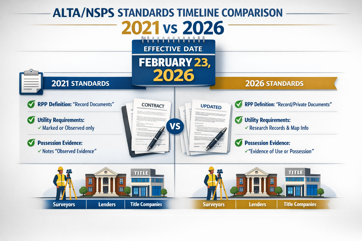
✅ Effective Date: All contracts executed on or after February 23, 2026, must comply with the new 2026 standards, with specific transition rules for pre-existing contracts[3].
✅ Clarified RPP Definition: The revised Relative Positional Precision definition improves accessibility and aligns with accepted measurement practices, making boundary accuracy more understandable[1].
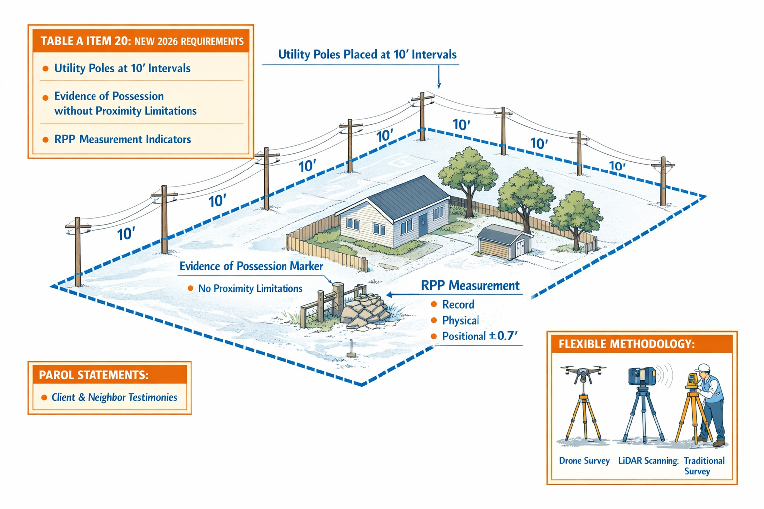
✅ Expanded Documentation Requirements: Evidence of possession must be noted regardless of proximity to boundaries, and utility feature requirements now extend to 10 feet for poles and 5 feet for other features[1][3].
✅ Technology-Friendly Standards: New flexible methodology language allows surveyors to employ emerging technologies like drones, LiDAR, and AI without requiring standard updates[1].
✅ Enhanced Transparency: New requirements for parol statements, optional summary tables (Table A Item 20), and clarified "update" definitions improve communication between all transaction parties[1][3].
Understanding the 2026 ALTA/NSPS Land Title Survey Standards Framework
What Are ALTA/NSPS Land Title Surveys?
ALTA/NSPS Land Title Surveys represent the gold standard for commercial real estate property surveys in the United States. These specialized surveys provide lenders, title companies, and property buyers with comprehensive information about property boundaries, improvements, easements, and potential encumbrances that could affect title insurance or financing decisions.
Unlike residential surveys, ALTA surveys follow nationally recognized standards that ensure consistency across state lines—critical for institutional lenders and national commercial real estate portfolios. The standards are jointly developed by ALTA (representing title insurance companies) and NSPS (representing professional surveyors), creating a balanced framework that serves both industries' needs.
Why the 2026 Updates Matter for CRE Transactions
The 2026 ALTA/NSPS Land Title Survey Updates address practical challenges that have emerged since the 2021 revision. These updates directly impact:
- Transaction timelines: Understanding new requirements prevents delays in closing
- Survey costs: Expanded documentation requirements may affect pricing
- Risk assessment: Enhanced disclosure requirements improve due diligence
- Technology adoption: Flexible methodology provisions enable faster, more accurate surveys
- Regulatory compliance: Mandatory law acknowledgments prevent legal complications
For chartered surveyors working across London and beyond, these standards influence international best practices even outside the United States, as ALTA surveys are frequently required for cross-border commercial transactions.
The Evolution from 2021 to 2026 Standards
The 2021 standards introduced significant changes, particularly around certification language and Table A optional items. The 2026 revision takes a more refinement-focused approach, addressing ambiguities and practical implementation challenges rather than wholesale restructuring[3].
Key philosophical shifts include:
- Clarity over complexity: Simplified language for technical concepts like RPP
- Technology enablement: Recognition that surveying methods evolve faster than standards
- Comprehensive disclosure: Expanded requirements for documenting physical conditions
- Legal alignment: Explicit acknowledgment of state-specific mandatory requirements
Critical Changes in the 2026 ALTA/NSPS Land Title Survey Updates: What Property Surveyors and CRE Professionals Need to Know
Effective Date and Transition Rules Explained
The February 23, 2026 effective date creates a clear dividing line for compliance[3]. However, the transition isn't always straightforward:
Contracts executed BEFORE February 23, 2026: May be completed under 2021 standards, even if the survey work or closing occurs after the effective date[3].
Contracts executed ON OR AFTER February 23, 2026: Must comply with 2026 standards, regardless of when the actual survey work is performed[3].
This distinction is crucial for CRE professionals managing transactions that span the effective date. Surveyors should document contract execution dates carefully and communicate clearly with clients about which standards apply to their specific engagement.
Pro Tip: Include explicit language in survey engagement agreements specifying which ALTA/NSPS standard version will govern the survey, particularly for contracts executed near the transition date.
Revised Relative Positional Precision (RPP) Definition
One of the most significant technical changes involves the Relative Positional Precision (RPP) definition. RPP measures the accuracy of boundary point locations relative to each other—essentially answering the question: "How confident can we be about where this boundary corner is located?"
What Changed: The 2026 standards provide a clarified definition that aligns with accepted measurement practices while improving accessibility for those unfamiliar with statistical surveying concepts[1].
Why It Matters:
- Lenders can better understand survey accuracy limitations
- Title companies can assess risk more accurately
- Surveyors have clearer guidance on measurement standards
- Property buyers understand boundary certainty levels
The revised definition doesn't fundamentally change how RPP is calculated but makes the concept more transparent to non-surveyors involved in commercial transactions. This democratization of technical knowledge supports better-informed decision-making throughout the transaction process.
Evidence of Possession Documentation (No Proximity Limitation)
Perhaps the most practically impactful change addresses evidence of possession or occupation. Section 5.C.i. now includes the phrase "regardless of proximity to perimeter boundary lines"[1][3].
Previous Ambiguity: The 2021 standards created confusion about whether evidence of possession only required documentation within 5 feet of boundaries[3].
2026 Clarification: Surveyors must now note ALL evidence of possession or occupation along the property perimeter, regardless of distance from the actual boundary line[1].
Examples of Evidence of Possession:
- 🚧 Fences (even if set back from the actual boundary)
- 🏗️ Walls or hedges indicating occupancy limits
- 🚗 Paved areas or driveways suggesting use boundaries
- 🌳 Landscaping features defining occupied areas
- 📦 Storage or equipment placement patterns
This change significantly impacts surveys of properties with complex occupancy patterns, particularly industrial sites, multi-tenant commercial properties, and properties with long-standing informal use arrangements. For professionals conducting boundary surveys, this expanded documentation requirement ensures comprehensive disclosure of potential boundary disputes or adverse possession claims.
Expanded Utility Feature Requirements
The 2026 standards introduce refined utility location requirements that address practical challenges in documenting utility infrastructure[1][3]:
| Utility Feature Type | Documentation Requirement |
|---|---|
| Utility Poles | Must be shown if located ON or WITHIN 10 feet of the property |
| Other Utility Features | Must be shown if located ON or WITHIN 5 feet of the property |
| Underground Utilities | Shown as per previous standards and available records |
Rationale: This refinement addresses the relationship between utility location requirements and easement evidence[3]. Utility poles often indicate overhead easements, while other features may suggest underground or access easements that affect property use and development potential.
Practical Implications:
- Surveyors must expand their field observation areas
- Utility company coordination may be required for feature identification
- Survey costs may increase for properties with extensive perimeter utility infrastructure
- Development feasibility assessments benefit from more complete utility mapping
Parol and Verbal Statements Documentation
A new requirement mandates notation of verbal or parol statements made by landowners or occupants pertaining to title of the property on the survey[1].
What Qualifies:
- Landowner claims about boundary locations
- Occupant statements about property use rights
- Verbal easement claims or access agreements
- Historical boundary information from long-term occupants
Documentation Standards:
- Statements must be clearly attributed to the source
- Surveyors should note these are unverified claims
- Written confirmation should be sought when possible
- Title companies and lenders should be alerted to significant claims
This requirement recognizes that valuable information about property rights often exists in oral form, particularly for older properties or those with long-standing family or business ownership. While such statements don't constitute legal evidence, they alert transaction parties to potential title issues requiring further investigation.
Similar to how professionals conduct schedule of condition reports to document property status, parol statements create a record of claimed rights that may affect future property use.
Flexible Methodology Language and Technology Adoption
One of the most forward-thinking changes involves flexible methodology provisions that future-proof the standards[1][3].
New Language: Standards now reference "practices generally recognized as acceptable by the surveying profession for purposes of an ALTA/NSPS Land Title Survey"[1][3].
Previous Approach: Specific procedural requirements that became outdated as technology evolved.
Technologies Now Explicitly Supported:
- 🚁 Drone surveys: For roof features, topography, and large-site documentation
- 📡 LiDAR scanning: For precise three-dimensional site mapping
- 🤖 AI-assisted analysis: For feature identification and measurement verification
- 📱 Mobile mapping systems: For efficient data collection
- 🛰️ Advanced GPS/GNSS: For high-precision positioning
This flexibility allows surveyors to employ the most efficient and accurate methods available without waiting for standard updates. For CRE professionals, this means potentially faster turnaround times and more detailed survey products as technology advances.
Professionals using drone roof surveys for building condition assessments can now apply similar technology to ALTA survey requirements with explicit standard support.
Compliance Requirements and Implementation Strategies
Step-by-Step Compliance Guide for Property Surveyors
Step 1: Update Engagement Agreements ✍️
- Specify which ALTA/NSPS standard version applies
- Include contract execution date documentation
- Clarify scope of utility feature documentation
- Address parol statement collection procedures
Step 2: Revise Field Procedures 📋
- Expand observation areas to capture 10-foot utility pole radius
- Document ALL evidence of possession regardless of proximity
- Implement parol statement collection protocols
- Train field crews on new documentation requirements
Step 3: Update Survey Templates and Certifications 📄
- Incorporate 2026 certification language
- Add Table A Item 20 if requested
- Include appropriate RPP disclosure language
- Ensure administrative rules acknowledgment is present
Step 4: Enhance Technology Integration 💻
- Evaluate drone, LiDAR, or mobile mapping adoption
- Document methodology choices in survey notes
- Ensure technology-derived data meets accuracy standards
- Maintain traditional verification methods as needed
Step 5: Improve Client Communication 📞
- Explain new requirements affecting scope and cost
- Clarify "update" versus "new survey" distinctions
- Provide education on RPP and accuracy concepts
- Set realistic timelines accounting for expanded documentation
Best Practices for Title Companies and Lenders
Title Company Considerations:
-
Title Commitment Timing: Provide title commitments to surveyors promptly, as they're required to have "a copy of the most recent title commitment or other title evidence satisfactory to the insurer"[3]
-
Exception Review: Pay particular attention to utility easements and possession evidence that may indicate title issues requiring exception or endorsement
-
Parol Statement Follow-Up: Investigate any verbal claims noted on surveys that could affect insurability
-
Table A Coordination: Communicate with surveyors and clients about optional items that may benefit the transaction
Lender Best Practices:
-
Underwriting Updates: Revise underwriting guidelines to reflect 2026 standard requirements
-
Survey Review Checklists: Update internal checklists to verify 2026 compliance for applicable transactions
-
Borrower Communication: Educate borrowers about potential survey cost increases due to expanded requirements
-
Timeline Adjustments: Build additional time into transaction schedules for more comprehensive survey documentation
-
Successor and Assign Certifications: Request certification extensions to successors and assigns when appropriate[1]
CRE Professional Action Items
Commercial real estate professionals should take proactive steps to integrate the 2026 ALTA/NSPS Land Title Survey Updates into transaction workflows:
For Buyers and Investors:
- Request Table A Item 20 summary tables for complex properties
- Review possession evidence carefully for potential boundary disputes
- Understand RPP limitations when evaluating boundary-dependent development plans
- Budget appropriately for potentially higher survey costs
For Property Managers and Owners:
- Maintain accurate records of verbal agreements or boundary understandings
- Document utility infrastructure changes
- Preserve historical boundary information for future transactions
- Consider proactive surveys before listing properties for sale
For Developers:
- Engage surveyors early in due diligence
- Discuss methodology options for large or complex sites
- Coordinate utility company engagement for easement verification
- Plan for extended survey timelines on properties with extensive perimeters
Similar to how professionals approach what survey you need for different property types, understanding which 2026 standard provisions most impact your specific transaction type enables better planning and risk management.
Table A Changes and Optional Item Updates
Understanding Table A Item 20: The New Summary Table
Table A Item 20 represents a significant enhancement to survey communication[1]. This optional item allows a summary table to appear on the plat or map face containing:
- Physical conditions affecting the property
- Potential encroachments identified during the survey
- References to specific locations on the survey where these items appear
Benefits for Transaction Parties:
📊 At-a-Glance Review: Busy professionals can quickly identify key issues without studying the entire survey
🎯 Focused Due Diligence: Directs attention to specific areas requiring further investigation
📝 Improved Communication: Reduces misunderstandings between surveyors, lenders, and title companies
⚖️ Risk Transparency: Makes potential issues more visible to decision-makers
When to Request Table A Item 20:
- Complex commercial properties with multiple buildings or tenants
- Properties with known boundary or encroachment issues
- Large-site industrial or institutional properties
- Transactions involving multiple stakeholders or approval layers
Table A Item 15 Imagery Revision
Table A Item 15 has been revised to revert to original intent regarding imagery-based documentation[3]. This change allows imagery (such as aerial photography or satellite imagery) to document certain features rather than requiring ground surveying.
Requirements for Using Imagery:
- Written agreement with the client, lender, AND title insurer[3]
- Appropriate notes on the plat/map identifying the imagery source[1]
- Specific sourcing details identified and agreed upon in writing[1]
- Accuracy appropriate for the features being documented
Appropriate Uses:
- Building footprints on large sites
- Vegetation or natural features
- Paved areas and parking lots
- General site context
Inappropriate Uses:
- Boundary determinations
- Encroachment measurements requiring precision
- Features requiring legal accuracy for title insurance
- Items where ground verification is legally mandated
This flexibility can significantly reduce survey costs and timelines for appropriate applications while maintaining accuracy where it matters most.
Mandatory Law Compliance Clarification
The 2026 standards include important clarification regarding mandatory legal requirements[3]. Some Table A items that appear "optional" in the national standards are actually mandatory under state or local law.
Common State-Mandated Requirements:
- Monument placement at boundary corners
- Specific certification language
- Recording of survey plats
- Particular notation standards for easements
- Minimum scale or sheet size requirements
Surveyor Responsibilities:
✅ Research applicable state and local laws
✅ Inform clients when "optional" items are legally required
✅ Include mandatory items even if not requested by the client
✅ Document legal basis for including non-requested items
Client Responsibilities:
✅ Understand that some Table A items aren't truly optional
✅ Work with surveyors familiar with local requirements
✅ Budget for legally mandated items regardless of perceived need
This clarification prevents situations where surveyors omit legally required elements based on client requests or cost considerations, protecting all parties from compliance issues.
The "Update" Myth: Understanding Survey Recertification
Why Survey "Updates" Don't Exist Under ALTA Standards
One of the most important clarifications in the 2026 ALTA/NSPS Land Title Survey Updates addresses the concept of survey "updates"[3]. The standards now explicitly state:
There is no such thing as a survey "update"
What This Means: Any recertification of a previous ALTA survey constitutes a new survey that must:
- Certify current property conditions
- Comply with current standards (2026 if contract executed after February 23, 2026)
- Include current certification language
- Reflect all changes since the previous survey
When Reduced Fees or Faster Turnaround Apply
While an "update" isn't technically possible, surveyors may offer reduced fees or expedited service when recertifying a property they previously surveyed[3].
Legitimate Reasons for Cost Reduction:
- Existing base mapping and boundary research
- Familiarity with property characteristics
- Available previous fieldwork data
- Established relationships with adjacent property owners
Work Still Required:
- Field verification of current conditions
- Documentation of any changes since previous survey
- Verification that previous boundary determinations remain valid
- New certification under current standards
- Title commitment review for new exceptions or requirements
Red Flags:
- Surveyors offering "updates" without site visits
- Significant cost reductions suggesting inadequate verification
- Refusal to certify under current standards
- Backdating of surveys or certifications
For professionals familiar with building surveys versus homebuyer reports, the distinction is similar—different levels of service exist, but each must meet its specific standard completely.
Title Commitment Requirements
The 2026 standards clarify that surveyors must be provided a copy of the most recent title commitment or other title evidence satisfactory to the title insurer[3].
Why This Matters:
- Surveyors must locate and verify easements shown in title documents
- New exceptions since previous surveys must be addressed
- Title commitment Schedule B requirements may affect survey scope
- Coordination between surveyor and title company is essential
Best Practices:
- Provide title commitments to surveyors at engagement
- Update surveyors if title commitments are revised
- Allow time for surveyor review before fieldwork
- Coordinate exception resolution between surveyor and title company
Impact on Commercial Real Estate Transactions and Lending
How 2026 Updates Affect Deal Timelines
The expanded documentation requirements in the 2026 ALTA/NSPS Land Title Survey Updates will likely impact transaction timelines:
Potential Timeline Extensions:
- +2-5 days: Expanded utility feature documentation
- +1-3 days: Evidence of possession documentation without proximity limits
- +1-2 days: Parol statement collection and verification
- Variable: Table A Item 20 preparation for complex properties
Timeline Mitigation Strategies:
- Engage surveyors during early due diligence
- Provide title commitments promptly
- Communicate clearly about Table A requirements upfront
- Consider preliminary surveys for complex properties
- Build buffer time into contract contingency periods
Implications for Loan Underwriting and Approval
Lenders should anticipate underwriting process adjustments:
Enhanced Risk Assessment:
- More complete utility easement information improves development feasibility analysis
- Possession evidence without proximity limits reveals potential boundary disputes earlier
- Parol statements alert underwriters to unrecorded claims requiring investigation
Documentation Requirements:
- Updated survey review checklists reflecting 2026 requirements
- Training for underwriters on new standard provisions
- Coordination protocols with title companies on possession evidence
- Escalation procedures for significant parol statements
Loan Committee Considerations:
- Budget impact of potentially higher survey costs
- Timeline adjustments for survey delivery
- Risk assessment of properties with complex possession patterns
- Technology-derived data quality assurance
Cost Implications for Buyers and Sellers
Expected Cost Increases:
Survey costs may increase 10-25% for typical commercial properties due to:
- Expanded field observation requirements
- Additional documentation and notation time
- Parol statement collection and verification
- Table A Item 20 preparation (when requested)
Cost Mitigation Approaches:
- Negotiate survey payment responsibility in purchase agreements
- Consider phased surveys for large portfolios
- Leverage technology for efficiency gains
- Request preliminary surveys for budgeting purposes
Long-Term Value:
While initial costs may increase, the enhanced information provided by 2026-compliant surveys offers:
- Better risk identification reducing post-closing surprises
- More complete due diligence supporting informed decisions
- Reduced title claim likelihood
- Improved development planning information
Similar to how property valuations require investment for accurate market assessment, comprehensive ALTA surveys provide essential information justifying their cost.
Technology Integration and Future-Proofing
Emerging Technologies in Land Title Surveying
The flexible methodology provisions in the 2026 standards explicitly enable cutting-edge surveying technologies:
Drone/UAV Applications:
- Roof and building feature documentation
- Large-site topographic mapping
- Aerial imagery for context
- Inaccessible area observation
- Rapid preliminary site assessment
LiDAR Scanning Benefits:
- Highly accurate three-dimensional site models
- Detailed building and improvement documentation
- Vegetation and topography mapping
- Integration with BIM for development planning
- Permanent digital record of site conditions
Artificial Intelligence Integration:
- Automated feature identification from imagery
- Change detection between survey dates
- Quality assurance and error checking
- Report generation and notation automation
- Pattern recognition for possession evidence
Mobile Mapping Systems:
- Efficient data collection for linear sites
- Integrated imagery and positioning
- Reduced field time requirements
- Enhanced safety on high-traffic sites
Quality Assurance for Technology-Derived Data
While technology offers efficiency and accuracy advantages, surveyors must maintain rigorous quality assurance:
Verification Requirements:
✓ Ground truth critical measurements
✓ Validate technology-derived data against traditional methods
✓ Document methodology and equipment specifications
✓ Maintain professional judgment over automated outputs
✓ Ensure accuracy meets ALTA standards regardless of method
Documentation Standards:
- Note technology used for data collection
- Specify accuracy specifications of equipment
- Describe processing methods for raw data
- Identify any limitations of technology-derived information
- Provide metadata for digital deliverables
Preparing for Future Standard Revisions
The 2026 standards' technology-friendly approach suggests future revisions will continue emphasizing flexibility and innovation:
Anticipated Future Trends:
- Increased digital deliverables: Interactive 3D models and GIS integration
- Real-time data sharing: Cloud-based survey data accessible to transaction parties
- Automated compliance checking: AI-assisted standard compliance verification
- Enhanced visualization: Virtual reality site tours and augmented reality boundary display
- Blockchain integration: Immutable survey records and certification tracking
Preparation Strategies:
- Invest in scalable technology platforms
- Develop digital workflow capabilities
- Train staff on emerging technologies
- Build relationships with technology vendors
- Participate in industry standard development processes
Regional Considerations and State-Specific Requirements
Variations in State Surveying Laws
While ALTA/NSPS standards provide national consistency, state laws create important variations:
Common State-Specific Requirements:
- Surveyor licensing and seal requirements
- Monument type and placement standards
- Survey plat recording mandates
- Specific certification language
- Minimum accuracy standards exceeding ALTA requirements
Research Resources:
- State surveying boards and professional associations
- State-specific ALTA/NSPS standard interpretations
- Local title company requirements
- Regional surveying practice guides
For professionals working across multiple jurisdictions, understanding these variations is essential. Just as chartered surveyors in different London areas must understand local planning requirements, ALTA surveyors must navigate state-specific regulations.
Multi-State Portfolio Considerations
Commercial real estate portfolios spanning multiple states face unique compliance challenges:
Portfolio Management Strategies:
- Engage surveyors licensed in each relevant state
- Develop state-specific survey requirement matrices
- Standardize optional Table A items across portfolio when possible
- Coordinate with title companies familiar with multi-state transactions
- Build state-specific requirement knowledge into due diligence checklists
Cost Optimization:
- Negotiate portfolio pricing with multi-state surveying firms
- Standardize scope to extent possible while respecting state requirements
- Leverage technology for efficiency across all locations
- Consider master service agreements for ongoing portfolio management
International Transaction Implications
While ALTA/NSPS standards are U.S.-specific, they influence international commercial real estate practice:
Cross-Border Applications:
- U.S. lenders financing foreign properties may request ALTA-style surveys
- International investors acquiring U.S. properties must understand ALTA requirements
- Survey standards in other countries increasingly reference ALTA practices
- Global portfolio management benefits from standardized survey approaches
Adaptation Strategies:
- Work with surveyors experienced in international standards
- Understand local equivalents to ALTA surveys in target countries
- Coordinate between U.S. and foreign title insurance requirements
- Budget for potential dual survey requirements (local and ALTA-style)
Training and Professional Development

Educational Resources for Surveyors
Staying current with the 2026 ALTA/NSPS Land Title Survey Updates requires ongoing education:
Recommended Training:
- NSPS/ALTA webinars on 2026 standards implementation
- State surveying association continuing education programs
- Technology vendor training on compliant methodology
- Title company educational sessions on insurer expectations
- Legal updates on state-specific requirements
Professional Development:
- Attend surveying conferences featuring ALTA standard sessions
- Participate in peer review groups discussing implementation challenges
- Contribute to professional publications sharing best practices
- Engage in standard development committees for future revisions
CRE Professional Education Needs
Real estate professionals benefit from understanding survey fundamentals:
Key Learning Areas:
- How to read and interpret ALTA surveys
- Understanding RPP and accuracy limitations
- Identifying red flags in survey certifications
- Coordinating survey requirements with transaction timelines
- Evaluating survey costs and scope appropriateness
Training Resources:
- Title company educational programs
- Commercial real estate association courses
- Lender training on survey review
- Online resources and webinars
- Surveyor-led client education sessions
Building Collaborative Relationships
Successful implementation of the 2026 standards requires strong collaboration between all transaction parties:
Relationship Building Strategies:
- Regular communication between surveyors, title companies, and lenders
- Joint training sessions for transaction team members
- Feedback loops for continuous improvement
- Technology platform integration for seamless data sharing
- Proactive problem-solving rather than reactive crisis management
Similar to how party wall matters require coordination between neighbors and surveyors, ALTA surveys benefit from collaborative approaches among all stakeholders.
Common Challenges and Solutions
Addressing Possession Evidence Documentation Challenges
The expanded possession evidence requirements create practical fieldwork challenges:
Challenge: Determining what constitutes "evidence of possession"
Solution: Develop clear field guides with photographic examples; when uncertain, document and note rather than omit
Challenge: Properties with extensive perimeters and numerous possession indicators
Solution: Leverage drone imagery for preliminary identification; prioritize significant features; use Table A Item 20 for summary presentation
Challenge: Contradictory possession evidence (fence lines not matching boundaries)
Solution: Document clearly with measurements; note discrepancies prominently; alert title company and client immediately
Challenge: Access limitations preventing complete perimeter observation
Solution: Document access limitations in survey notes; coordinate with property owners for access; consider alternative observation methods
Managing Utility Feature Documentation
The refined utility requirements present coordination and identification challenges:
Challenge: Identifying utility ownership and type
Solution: Contact utility companies early; use utility location services; document "unknown" utilities appropriately
Challenge: Dense utility infrastructure requiring extensive documentation
Solution: Use technology (mobile mapping, photogrammetry) for efficiency; consider scaled detail drawings for complex areas
Challenge: Underground utilities without surface evidence
Solution: Rely on utility company records; note limitations of underground utility location; recommend subsurface utility engineering for critical projects
Challenge: Utilities just beyond documentation thresholds
Solution: Use professional judgment; document borderline features when they may affect property use; note proximity measurements
Handling Parol Statement Collection
The new parol statement requirement raises liability and documentation concerns:
Challenge: Landowners making claims contradicting title records
Solution: Document statements verbatim; clearly note they are unverified; immediately alert title company and client
Challenge: Reluctant or unavailable landowners
Solution: Document attempts to contact; note inability to obtain statements; don't delay survey completion waiting for statements
Challenge: Liability for recording incorrect or fraudulent statements
Solution: Clearly attribute statements to source; include disclaimer that statements are unverified; maintain detailed notes of conversations
Challenge: Determining which statements are relevant to title
Solution: Err on side of inclusion; focus on boundary, easement, and access claims; consult with title company when uncertain
Practical Implementation Checklist
For Property Surveyors
Pre-Engagement:
- Update engagement agreement templates with 2026 standard language
- Revise fee schedules accounting for expanded requirements
- Train field crews on new documentation requirements
- Update survey plat templates and certification language
During Survey Process:
- Confirm contract execution date and applicable standard version
- Obtain and review current title commitment
- Document utility features within required distances
- Note ALL possession evidence regardless of proximity
- Collect and document relevant parol statements
- Employ appropriate technology with proper documentation
Deliverable Preparation:
- Include Table A Item 20 if requested
- Verify certification language matches 2026 standards
- Confirm all mandatory state requirements included
- Provide clear RPP disclosure
- Note methodology used for technology-derived data
For Title Companies
Transaction Initiation:
- Provide title commitment to surveyor promptly
- Communicate any unusual title issues requiring survey attention
- Confirm Table A optional items with client and lender
- Verify surveyor familiarity with 2026 standards
Survey Review:
- Confirm 2026 standard compliance for applicable transactions
- Review possession evidence for potential title issues
- Investigate parol statements affecting insurability
- Verify utility easements match survey documentation
- Coordinate exception resolution with surveyor
Closing Preparation:
- Ensure survey certification includes appropriate parties
- Confirm successor and assign language if requested
- Address any survey-identified title issues
- Maintain survey in permanent transaction file
For Lenders and CRE Professionals
Due Diligence Planning:
- Engage surveyor early in transaction timeline
- Budget appropriately for 2026-compliant survey costs
- Communicate Table A requirements clearly
- Provide title commitment to surveyor promptly
- Build adequate time into contingency periods
Survey Review and Analysis:
- Verify 2026 standard compliance for applicable contracts
- Review possession evidence for development implications
- Assess utility infrastructure impact on property use
- Investigate parol statements with legal counsel
- Confirm RPP meets underwriting requirements
Transaction Management:
- Coordinate survey exception resolution
- Address boundary or encroachment issues before closing
- Ensure survey certification includes lender
- Maintain survey in permanent loan file
- Update property records with survey information
Similar to conducting thorough dilapidation surveys before lease commencement, comprehensive ALTA survey review prevents costly post-closing discoveries.
Conclusion: Navigating the 2026 ALTA/NSPS Standards Successfully
The 2026 ALTA/NSPS Land Title Survey Updates: What Property Surveyors and CRE Professionals Need to Know represent a thoughtful evolution of surveying standards that balance technological advancement with enhanced disclosure requirements. While the changes introduce new documentation obligations and potential cost implications, they ultimately serve the interests of all transaction parties by providing more complete, accurate, and transparent property information.
Key Success Factors
For Surveyors: Embrace the flexible methodology provisions to enhance efficiency while maintaining rigorous quality standards. Invest in technology and training that position your practice for future standard evolution. Communicate clearly with clients about new requirements and their implications.
For Title Companies: Strengthen coordination with surveyors through early title commitment delivery and responsive communication. Develop robust survey review procedures that leverage enhanced disclosure requirements for better risk assessment.
For Lenders: Update underwriting guidelines and internal procedures to reflect 2026 requirements. Build appropriate timelines and budgets into transaction planning. Train staff on interpreting enhanced survey information for better lending decisions.
For CRE Professionals: Understand how the 2026 updates affect transaction timelines, costs, and due diligence processes. Engage qualified professionals early and communicate requirements clearly. Leverage enhanced survey information for better property assessment and risk management.
Actionable Next Steps
- Review Current Processes: Audit existing survey ordering, review, and approval procedures against 2026 requirements
- Update Documentation: Revise engagement agreements, review checklists, and internal guidelines
- Invest in Training: Ensure all team members understand the 2026 changes and their implications
- Strengthen Relationships: Build collaborative partnerships between surveyors, title companies, and lenders
- Embrace Technology: Explore how emerging technologies can improve efficiency while maintaining compliance
- Monitor Implementation: Track early experiences with 2026 standards to identify best practices and challenges
- Stay Informed: Participate in professional development and industry discussions about standard interpretation
Looking Forward
The 2026 standards' emphasis on flexibility and technology enablement suggests that future revisions will continue adapting to industry evolution. By understanding and implementing these updates effectively, surveyors and CRE professionals position themselves for success not only in 2026 but in the years ahead as surveying practices continue advancing.
The transition to the 2026 standards presents both challenges and opportunities. Those who approach implementation strategically—investing in training, technology, and collaborative relationships—will find that the enhanced information and improved processes ultimately benefit all parties to commercial real estate transactions.
Whether you're conducting surveys, underwriting loans, insuring title, or investing in commercial property, the 2026 ALTA/NSPS Land Title Survey Updates will shape your work for years to come. By understanding these changes thoroughly and implementing them thoughtfully, you'll be well-positioned to navigate the evolving landscape of commercial real estate due diligence with confidence and competence.
For additional guidance on property surveys and professional surveying services, explore our comprehensive resources on what survey you need for your specific property type and transaction requirements.
References
[1] New 2026 Minimum Standard Detail Requirements For Land Title Surveys – https://www.harrisbeachmurtha.com/insights/new-2026-minimum-standard-detail-requirements-for-land-title-surveys/
[2] 20260126 Alta Insights Understanding The 2026 Altansps Land Title Survey Standards – https://www.alta.org/news-and-publications/news/20260126-ALTA-Insights-Understanding-the-2026-ALTANSPS-Land-Title-Survey-Standards
[3] The 2026 Minimum Standard Detail Requirements For Alta Nsps Land Title Surveys – https://amerisurv.com/2026/02/01/the-2026-minimum-standard-detail-requirements-for-alta-nsps-land-title-surveys/
[4] The 2026 Minimum Standards For Alta Nsps Land Title Surveys – https://halfmoonseminars.org/product/webinars/the-2026-minimum-standards-for-alta-nsps-land-title-surveys/
[5] 2026 Alta Nsps Land Title Survey Standards – https://www.partneresi.com/resources/references/standards-regulations/2026-alta-nsps-land-title-survey-standards/
[6] Alta Standards Updated – https://cretelligent.com/alta-standards-updated/