When a council tenant notices damp spreading across their bedroom wall or cracks appearing in their ceiling, the person who holds the key to resolving these issues is often a surveyor council housing specialist. These professionals serve as the critical link between local authorities, housing associations, and the thousands of families living in social housing across the UK. Understanding their role, responsibilities, and how they operate can make a significant difference in ensuring safe, well-maintained homes for council tenants.
Key Takeaways
- Council housing surveyors are qualified professionals who inspect, assess, and report on the condition of social housing properties owned by local authorities and housing associations
- These surveyors have specific responsibilities under the Housing Health and Safety Rating System (HHSRS) and must ensure properties meet minimum standards for tenant safety
- Tenants have legal rights to request surveys when reporting disrepair, and councils must respond within specified timeframes
- The role differs significantly from private sector surveyors, with greater emphasis on statutory obligations, tenant welfare, and public accountability
- Understanding the survey process helps tenants advocate for necessary repairs and improvements to their homes
What Is a Surveyor Council Housing Specialist?
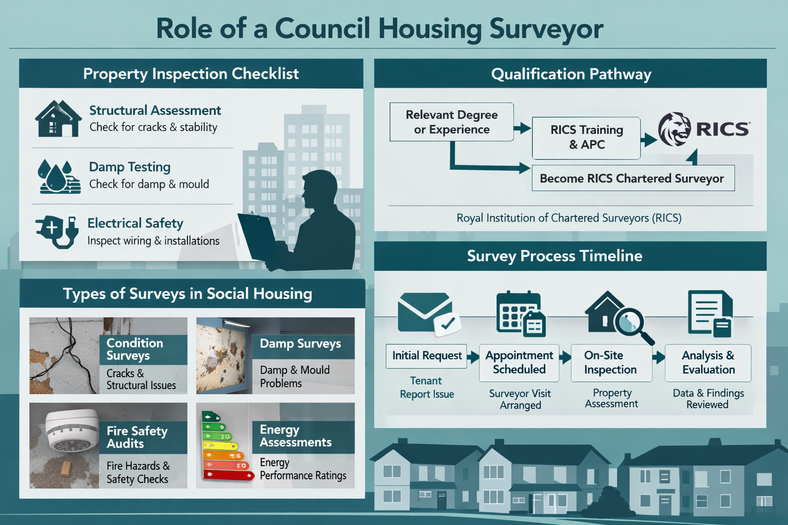
A surveyor council housing professional is a qualified expert who works specifically within the social housing sector. These surveyors are employed by local councils, housing associations, or work as independent consultants contracted to assess properties in the public housing stock.
Core Responsibilities
Council housing surveyors perform several essential functions:
- Property condition assessments to identify defects, disrepair, and safety hazards
- Pre-acquisition surveys when councils purchase properties to add to their housing stock
- Planned maintenance inspections to schedule preventative work across housing estates
- Disrepair investigations following tenant complaints about property conditions
- Stock condition surveys to evaluate the overall state of the council's housing portfolio
These professionals must hold relevant qualifications, typically from the Royal Institution of Chartered Surveyors (RICS), and possess specialized knowledge of social housing legislation, building regulations, and tenant rights.
"Council housing surveyors serve a dual purpose: they protect the local authority's property assets while ensuring tenants live in safe, decent homes that meet legal standards."
The Legal Framework Governing Surveyor Council Housing Work
The work of surveyor council housing specialists is governed by a comprehensive legal framework that places specific obligations on social landlords.
Housing Health and Safety Rating System (HHSRS)
Introduced in 2006, the HHSRS is the primary tool surveyors use to assess housing conditions. This risk-based evaluation system examines 29 potential hazards across four categories:
| Category | Hazard Examples | Risk Level |
|---|---|---|
| Physiological Requirements | Damp and mould, excess cold, excess heat | Category 1 or 2 |
| Psychological Requirements | Crowding and space, entry by intruders | Category 1 or 2 |
| Protection Against Infection | Domestic hygiene, pests and refuse | Category 1 or 2 |
| Protection Against Accidents | Falls, electrical hazards, fire | Category 1 or 2 |
Category 1 hazards pose a serious and immediate risk to health and safety, requiring urgent action. Category 2 hazards are less serious but still require attention.
Tenant Rights and Survey Requests
Council tenants have specific rights when it comes to property inspections:
✅ Right to request a survey when reporting disrepair or unsafe conditions
✅ Right to be present during the inspection
✅ Right to receive a copy of the survey report (in some circumstances)
✅ Right to challenge findings if they disagree with the surveyor's assessment
✅ Right to escalate through the council's complaints procedure or housing ombudsman
Understanding these rights is crucial for tenants seeking to improve their living conditions. Professional chartered surveyors can provide independent assessments when disputes arise between tenants and local authorities.
Types of Surveys Conducted in Council Housing
Surveyor council housing professionals conduct various types of inspections depending on the circumstances and requirements.
Disrepair Surveys
These are the most common surveys requested by tenants. When a resident reports issues such as:
- 💧 Persistent damp or mould growth
- 🏘️ Structural defects or cracks
- ⚡ Electrical problems or safety concerns
- 🛁 Plumbing failures or water leaks
- 🪟 Broken windows or doors
A disrepair survey investigates the complaint, identifies the cause, assesses the severity, and recommends remedial action. The surveyor must determine whether the council is responsible for the repairs under the tenancy agreement.
Stock Condition Surveys
Local authorities conduct periodic stock condition surveys across their entire housing portfolio. These comprehensive assessments:
- Evaluate the physical condition of buildings
- Identify upcoming maintenance needs
- Calculate investment requirements over 30-year periods
- Ensure compliance with the Decent Homes Standard
- Inform capital investment planning
Pre-Tenancy Surveys
Before a property is allocated to a new tenant, surveyors inspect to ensure it meets minimum standards. This "void property inspection" checks:
- All essential amenities are functional
- The property is safe and habitable
- Any necessary repairs are completed before occupation
- The property meets energy efficiency standards
For tenants considering property valuations or understanding property conditions, these surveys provide important baseline information.
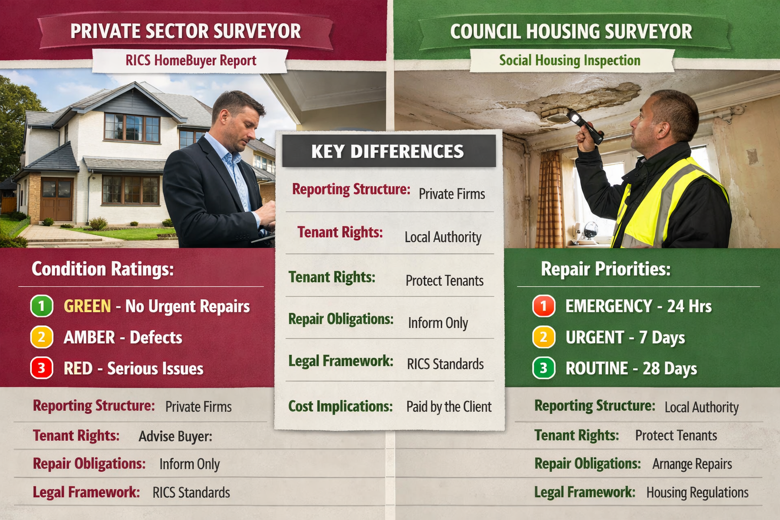
How Council Housing Surveyors Differ from Private Sector Surveyors
While both work in property assessment, surveyor council housing specialists operate in a distinctly different context from those in the private sector.
Key Differences
Accountability Structure: Council surveyors answer to elected officials and ultimately to the public, creating different pressures and priorities compared to private sector surveyors who serve individual clients.
Legal Obligations: Social landlords have statutory duties under the Landlord and Tenant Act 1985, Housing Act 2004, and other legislation that don't apply to private homeowners.
Tenant Vulnerability: Council housing residents often include vulnerable populations with limited housing options, requiring surveyors to consider welfare implications in their assessments.
Budget Constraints: Local authorities work within public sector budgets, meaning surveyors must balance tenant needs against financial limitations and competing priorities.
Repair Responsibilities: Unlike private homeownership, council tenancies have clear divisions of repair responsibility, with landlords responsible for structure, exterior, and installations.
Private sector professionals, such as those offering commercial property surveying services, focus on different priorities like investment value and commercial viability.
The Survey Process: What Tenants Can Expect
Understanding the typical surveyor council housing inspection process helps tenants prepare and engage effectively.
Step 1: Initial Report and Request
The process begins when a tenant reports a problem through the council's repairs service. For non-emergency issues, the council should acknowledge the report and schedule an initial inspection.
Step 2: Surveyor Appointment
The council assigns a surveyor to investigate. Tenants should receive:
- 📅 Reasonable notice of the inspection date and time
- 📋 Information about what the survey will cover
- 👤 Contact details for the surveyor or surveying team
Step 3: The Inspection
During the visit, the surveyor will:
- Examine the reported problem in detail
- Investigate potential causes (which may involve accessing other areas)
- Take photographs and measurements
- Ask questions about when issues started and any previous repairs
- Explain preliminary findings (though the formal report comes later)
Tenant Tip: Document everything before the survey with your own photos and notes, including dates when problems first appeared.
Step 4: Report and Recommendations
The surveyor prepares a report that typically includes:
- Description of defects found
- Assessment of severity and urgency
- Identification of the cause
- Determination of responsibility (council or tenant)
- Recommended remedial works
- Cost estimates and timescales
Step 5: Action Plan
Based on the report, the council should:
- Approve necessary repairs
- Schedule work according to priority
- Communicate timescales to the tenant
- Arrange access for contractors
If the surveyor determines the council is not responsible, they should explain why and advise on next steps.
Common Issues Identified by Council Housing Surveyors
Surveyor council housing professionals frequently encounter recurring problems across social housing stock.
Damp and Condensation
This is the most common complaint in council housing. Surveyors must distinguish between:
- Penetrating damp: Water entering through defects in the building fabric
- Rising damp: Moisture from the ground rising through walls
- Condensation: Moisture from daily activities with inadequate ventilation
Each type requires different solutions, from structural repairs to improved ventilation or tenant education about heating and airflow.
Structural Issues
Older council housing stock may develop:
- Subsidence or settlement cracks
- Roof deterioration and leaks
- Window and door frame failures
- Balcony and walkway defects (particularly in high-rise blocks)
These issues often require significant investment and may trigger wider regeneration projects.
Heating and Energy Efficiency
Many council properties struggle with:
- Outdated heating systems
- Poor insulation
- Single-glazed windows
- High energy costs for tenants
Surveyors play a crucial role in identifying properties for energy efficiency upgrades, helping councils meet carbon reduction targets while reducing fuel poverty.
Fire Safety
Following the Grenfell Tower tragedy, fire safety has become a critical focus. Surveyors assess:
- Fire door integrity
- Compartmentation and fire stopping
- Means of escape
- External wall systems
- Fire detection and alarm systems
This specialized work often requires additional qualifications in fire safety engineering.
For properties with specific concerns, party wall matters may also need consideration, particularly in terraced council housing.
Qualifications and Professional Standards for Council Housing Surveyors
To work as a surveyor council housing professional, individuals must meet rigorous qualification requirements.
Educational Pathways
Most council housing surveyors hold:
- RICS-accredited degree in Building Surveying, Quantity Surveying, or related discipline
- RICS Assessment of Professional Competence (APC) leading to chartered status
- Continuing Professional Development (CPD) to maintain current knowledge
Specialist Knowledge Areas
Beyond general surveying skills, council housing specialists need expertise in:
- 📚 Social housing legislation and tenant rights
- 🏗️ Common defects in various construction types (traditional brick, system-built, concrete)
- 🔍 HHSRS assessment methodology
- ♿ Accessibility standards and adaptations
- 💰 Cost estimation and budget management
- 📝 Report writing for various audiences (technical, legal, tenant-facing)
Professional Bodies and Oversight
Council housing surveyors typically belong to:
- Royal Institution of Chartered Surveyors (RICS): Setting professional standards and ethics
- Chartered Institute of Building (CIOB): For those with construction management focus
- Association of Building Engineers (ABE): Alternative professional body
These organizations provide guidance, enforce standards, and offer disciplinary procedures for professional misconduct.
Challenges Facing Council Housing Surveyors in 2026
The role of surveyor council housing professionals continues to evolve amid significant challenges.
Aging Housing Stock
Much of the UK's council housing was built between the 1950s and 1970s, meaning:
- Properties are reaching the end of their design life
- Major components require replacement
- Some construction methods (like concrete systems) present unique challenges
- Backlog maintenance has accumulated over decades of underinvestment
Increased Demand and Reduced Resources
Local authorities face:
- Growing waiting lists for social housing
- Budget pressures limiting repair spending
- Staff shortages in surveying departments
- Pressure to maintain properties for longer periods
These factors create difficult decisions about resource allocation and repair prioritization.
Regulatory Changes
New and evolving regulations require surveyors to stay current with:
- Building Safety Act 2022 requirements
- Updated fire safety standards
- Energy Performance Certificate (EPC) improvements
- Accessibility and adaptation standards
Tenant Expectations
Modern tenants increasingly:
- Understand their rights and are willing to assert them
- Use social media to highlight poor conditions
- Seek legal advice and pursue disrepair claims
- Expect communication and transparency
This requires surveyors to balance technical expertise with strong communication skills and empathy.
Similar challenges affect professionals across the sector, including those working in leasehold property matters.
Technology and Innovation in Council Housing Surveying
Modern surveyor council housing work increasingly incorporates technological advances.
Digital Survey Tools
Contemporary surveyors use:
- 📱 Tablet-based survey apps for on-site data capture and instant report generation
- 📷 Thermal imaging cameras to detect hidden damp, insulation defects, and heat loss
- 📐 Laser measuring devices for accurate dimensions without physical measurement
- 🚁 Drones for roof and high-level inspections without scaffolding
Data Management Systems
Local authorities implement:
- Asset management databases tracking every property's condition and repair history
- Predictive maintenance algorithms identifying properties likely to develop problems
- Mobile workforce management optimizing surveyor routes and scheduling
- Tenant portals allowing residents to track repair progress
Building Information Modeling (BIM)
Progressive councils adopt BIM to:
- Create digital twins of housing stock
- Plan maintenance more effectively
- Visualize proposed improvements
- Integrate surveying data with other systems
These technologies improve efficiency, consistency, and outcomes for both councils and tenants.
When to Seek an Independent Survey
While councils employ their own surveyors, tenants sometimes benefit from independent assessments.
Circumstances Warranting Independent Surveys
Consider engaging an independent surveyor when:
- 🔴 The council disputes your disrepair claim
- 🔴 Repairs have been delayed unreasonably
- 🔴 You're considering legal action for disrepair
- 🔴 Health issues may be linked to property conditions
- 🔴 You need expert evidence for court proceedings
Independent surveyors provide:
- Objective, unbiased assessments
- Expert witness services for legal cases
- Detailed reports suitable for court proceedings
- Leverage in negotiations with the council
Professional firms offering comprehensive surveying services can provide this independent expertise across various locations, including chartered surveyors in London and surrounding areas like Surrey.
Cost Considerations and Funding
Understanding the financial aspects of surveyor council housing work helps contextualize decision-making.
Council Repair Budgets
Local authorities allocate funds through:
- Revenue budgets for day-to-day repairs and maintenance
- Capital budgets for major works and improvements
- Decent Homes funding for bringing properties to standard
- Energy efficiency grants from government schemes
Surveyors must work within these constraints, prioritizing urgent safety issues while managing non-critical repairs.
Tenant Costs
Council tenants typically pay:
- Nothing for repairs that are the landlord's responsibility
- Charges for damage caused by the tenant or their visitors
- Rechargeable repairs for items the tenant is responsible for maintaining
Surveyors determine responsibility, which directly affects whether tenants face charges.
Independent Survey Costs
If tenants commission independent surveys, typical costs range from:
- £300-£600 for basic disrepair surveys
- £600-£1,200 for comprehensive condition assessments
- £1,500+ for expert witness reports for legal proceedings
Many tenants access these services through:
- Legal aid (if eligible)
- No-win-no-fee solicitors handling disrepair claims
- Housing charity support programs
The Future of Council Housing Surveying
The role of surveyor council housing professionals will continue evolving in response to emerging priorities.
Sustainability and Net Zero
Surveyors will increasingly focus on:
- Retrofitting properties for energy efficiency
- Assessing suitability for heat pumps and renewable energy
- Reducing carbon emissions from housing stock
- Balancing heritage conservation with sustainability
Building Safety Culture
Post-Grenfell reforms emphasize:
- Rigorous safety assessments
- Clear accountability chains
- Resident engagement in safety matters
- Transparent reporting of defects and risks
Preventative Approaches
Forward-thinking councils shift from reactive repairs to:
- Predictive maintenance using data analytics
- Proactive component replacement before failure
- Whole-life costing in decision-making
- Investment in quality to reduce long-term costs
Tenant Empowerment
The future involves:
- Greater tenant involvement in survey processes
- Transparent sharing of condition data
- Co-design of improvement programs
- Recognition of residents as experts in their homes
These trends will reshape how surveyor council housing professionals work, requiring new skills and approaches alongside traditional technical expertise.
Conclusion: The Vital Role of Council Housing Surveyors
Surveyor council housing specialists occupy a unique and essential position in ensuring safe, decent homes for millions of people across the UK. Their work bridges technical expertise, legal requirements, and social responsibility, directly impacting the daily lives of council tenants.
For tenants experiencing problems with their council homes, understanding the surveyor's role, the inspection process, and your rights empowers you to advocate effectively for necessary repairs. Remember that surveyors should be allies in maintaining housing quality, even when resource constraints create challenges.
Next Steps for Council Tenants
If you're facing issues with your council property:
- Document everything with photos, dates, and descriptions of problems
- Report formally through your council's repairs system, keeping copies of all communications
- Request a survey if initial repairs don't resolve the issue
- Understand your rights under housing legislation and your tenancy agreement
- Escalate appropriately through complaints procedures if necessary
- Consider independent advice from housing charities or legal services if disputes arise
- Seek professional support from independent surveyors when needed
The relationship between council housing surveyors, local authorities, and tenants works best when all parties understand their roles, rights, and responsibilities. By engaging constructively with the survey process and holding councils accountable for their legal obligations, tenants can help ensure their homes meet the standards everyone deserves.
Whether you're a council tenant seeking repairs, a housing professional looking to understand best practices, or simply interested in how social housing works, the role of qualified surveyors remains central to delivering quality, safe, and well-maintained homes for communities across the country.
Book with Kingston Surveyors
Kingston Surveyors arranges RICS surveys, valuations and party wall services across London and the surrounding counties. Call 0204 579 8270 for a fixed same-day quote, or send us the property details and we will organise the right professional for the job.


