The surveying industry has undergone a remarkable transformation in 2026. Traditional measurement methods that once required weeks of fieldwork can now be completed in hours with unprecedented precision. 3D Laser Scanning Mastery: Boosting Accuracy in Modern Property Surveys represents the cutting edge of this revolution, combining terrestrial laser scanning (TLS) with mobile SLAM technology and seamless Building Information Modeling (BIM) integration to deliver survey-grade accuracy at speeds previously thought impossible. 🚀
As property development projects grow more complex and construction timelines compress, the demand for precise, comprehensive spatial data has never been greater. Modern laser scanning technology answers this challenge by capturing millions of measurement points per second, creating detailed digital twins of existing conditions that serve as the foundation for informed decision-making throughout the project lifecycle.
Key Takeaways
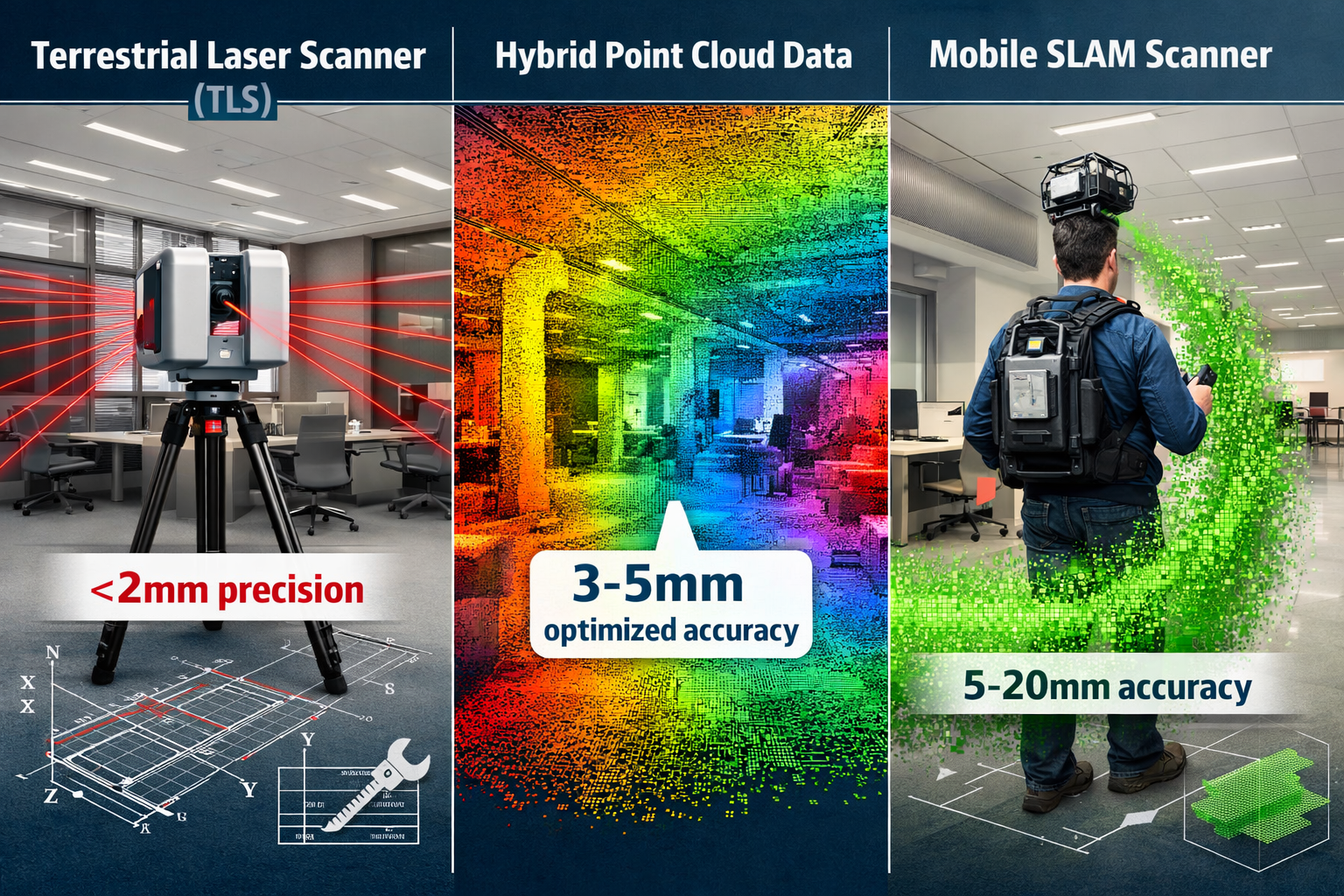
- Hybrid workflows combining static TLS and mobile SLAM now deliver optimized accuracy of 3-5 mm while reducing field time by up to 80% compared to traditional surveying methods[1]
- Real-time quality monitoring integrated into 2026 mobile scanners enables adaptive field workflows and eliminates costly return visits for data gaps[1]
- BIM integration transforms raw point cloud data into actionable 3D models that facilitate collaboration, clash detection, and design validation before construction begins[3]
- Safety and cost improvements allow surveyors to capture hazardous or inaccessible areas remotely while reducing project costs through fewer field trips and minimized rework[4]
- Regulatory evolution including the 2026 ALTA/NSPS Guidelines reflects industry-wide adoption of advanced capture technologies as the new standard[8]
Understanding 3D Laser Scanning Technology in 2026
The Evolution from Traditional to Digital Surveying
Traditional property surveying relied on manual measurements using total stations, tape measures, and extensive field notes. Surveyors would spend days or weeks collecting individual data points, then additional time processing this information into usable drawings. This labor-intensive approach introduced multiple opportunities for human error and struggled to capture the full complexity of existing structures.
3D laser scanning fundamentally changes this paradigm by automating data capture at unprecedented speed and density. Modern laser scanners emit rapid pulses of laser light—often millions per second—and measure the time it takes for each pulse to reflect back from surfaces. This time-of-flight measurement, combined with the scanner's precise angular position, calculates the exact three-dimensional coordinates of each point.
The result is a point cloud: a dense collection of millions or billions of precisely measured points that together create a highly detailed digital representation of the scanned environment. This digital twin captures not just basic dimensions but also surface textures, structural details, and spatial relationships that would be impractical to measure manually.
Terrestrial Laser Scanning: The Precision Backbone
Terrestrial laser scanners (TLS) from manufacturers like Leica, Trimble, and FARO represent the gold standard for survey accuracy. These tripod-mounted instruments deliver sub-millimeter local accuracy—typically less than 2 mm—establishing drift-free control networks that serve as the geometric "truth" for projects[1].
Static TLS excels in scenarios requiring maximum precision:
- Structural monitoring where millimeter-level deformation detection is critical
- Subsidence surveys requiring precise vertical measurements
- Control point establishment for georeferencing larger mobile scans
- High-detail architectural documentation of heritage buildings or complex facades
The primary limitation of static scanning is coverage efficiency. Each scanner setup captures data from a single position, requiring multiple setups to document large or complex spaces. Surveyors must carefully plan scan positions to ensure complete coverage while minimizing occlusions (areas blocked from view).
Mobile SLAM Technology: Speed Meets Practicality
Mobile laser scanning using Simultaneous Localization and Mapping (SLAM) technology addresses the coverage challenge by enabling continuous data capture while the operator walks through a space. Wearable or handheld devices like the NavVis VLX 3 combine multi-layer LiDAR sensors with high-resolution panoramic cameras and inertial measurement units (IMUs) to track their position while simultaneously building a 3D map[1].
Mobile SLAM scanners operating independently achieve 5-20 mm accuracy—less precise than static TLS but perfectly adequate for many applications[1]:
- Rapid volumetric capture of large commercial properties
- Interior documentation for renovation planning
- As-built verification for construction progress monitoring
- Facility management and space planning
The key advantage is speed and coverage. A single operator can capture an entire multi-story building in hours, documenting spaces that would require dozens of static scanner setups. Modern 2026 devices feature integrated screens displaying real-time confidence maps that alert operators to feature-poor environments (long corridors, blank walls) where SLAM drift is likely, enabling adaptive scanning strategies[1].
3D Laser Scanning Mastery: Implementing Hybrid Workflows for Optimal Accuracy
The Precision Backbone Approach
The dichotomy between static and mobile scanning has collapsed in 2026. Leading surveying firms now deploy a tiered "precision backbone" approach that strategically combines both technologies to optimize the accuracy-efficiency tradeoff[1].
This hybrid methodology works as follows:
Step 1: Establish Static Control Network
Begin by positioning terrestrial laser scanners at strategic locations throughout the survey area. These high-precision scans serve multiple purposes:
- Create a geometric control framework with survey-grade accuracy
- Capture critical detail in areas requiring maximum precision
- Provide reference targets for mobile scan registration
Step 2: Rapid Mobile Capture
With the control network established, deploy mobile SLAM scanners to rapidly document the remaining areas. The mobile scanner captures complete coverage including:
- Interior spaces between static scan positions
- Continuous corridor and circulation path documentation
- Areas with complex geometry or numerous occlusions
Step 3: Hybrid Data Fusion
Modern registration software fuses the static TLS and mobile SLAM datasets using sophisticated algorithms that:
- Align mobile scans to the high-precision static control network
- Minimize accumulated SLAM drift by constraining to known control points
- Produce unified point clouds with optimized accuracy of approximately 3-5 mm[1]
This approach delivers the best of both worlds: survey-grade precision where it matters most, combined with rapid, complete coverage of the entire property.
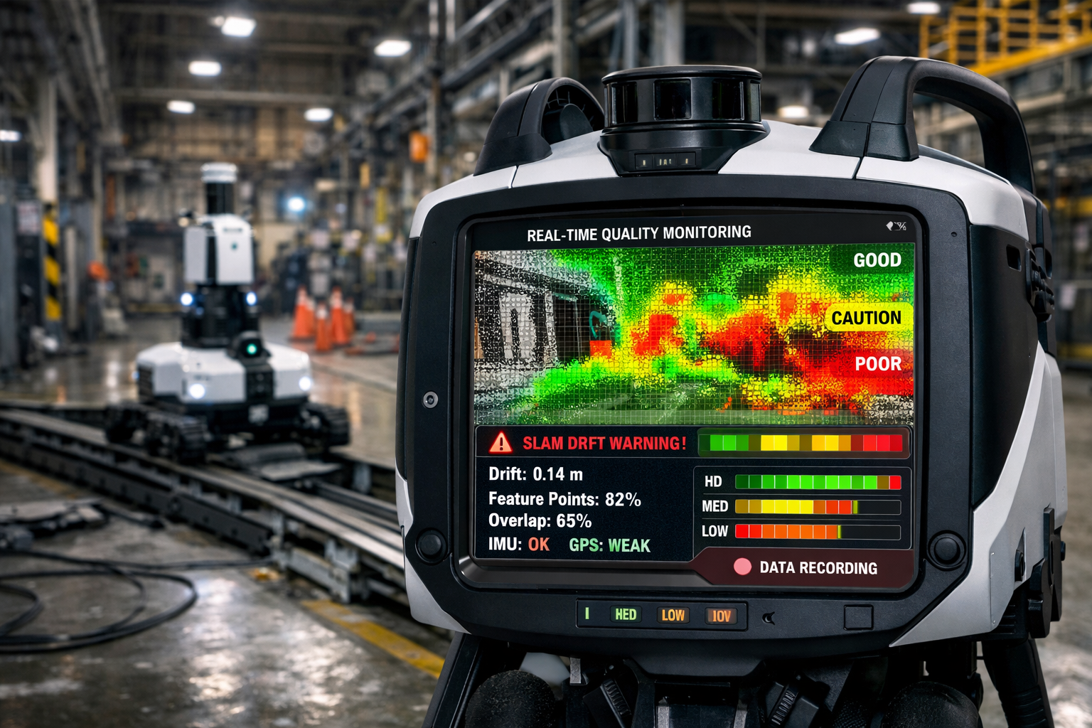
Real-Time Quality Assurance in the Field
One of the most significant advances in 3D Laser Scanning Mastery: Boosting Accuracy in Modern Property Surveys is the integration of real-time quality monitoring directly into field workflows. Gone are the days of discovering data gaps or quality issues only after returning to the office.
Modern 2026 mobile scanners feature integrated displays showing:
- Confidence heat maps that visualize SLAM tracking quality in real-time using color coding (green for good, yellow for caution, red for poor tracking)
- Coverage visualization highlighting areas already scanned versus gaps requiring additional passes
- Point density metrics ensuring adequate detail capture for project requirements
- Registration preview showing how current scans align with previously captured data
This immediate feedback enables surveyors to make informed decisions in the field:
- Adjust scanning speed in feature-poor areas to improve tracking
- Add supplementary static scans in critical zones
- Verify complete coverage before demobilizing from site
- Optimize scan paths for efficiency while maintaining quality standards
The result is dramatically reduced need for costly return visits and faster project delivery timelines[2].
Integration with Autonomous and Robotic Capture
Hybrid 2026 workflows increasingly integrate autonomous robotic capture into unified survey stacks. This technology deploys laser scanners on remote-controlled platforms including:
- Ground-based robots for hazardous industrial environments
- Rail-mounted systems for tunnel and infrastructure surveys
- Climbing robots for bridge and tower inspection
- Underwater remotely operated vehicles (ROVs) for submerged structure documentation
These robotic systems enhance both safety and efficiency by accessing dangerous or difficult locations without exposing personnel to risk[1][2]. For boundary surveys involving steep embankments or unstable terrain, robotic scanners can capture precise data while operators remain in safe positions.
BIM Integration: Transforming Point Clouds into Actionable Intelligence
From Raw Data to Information-Rich Models
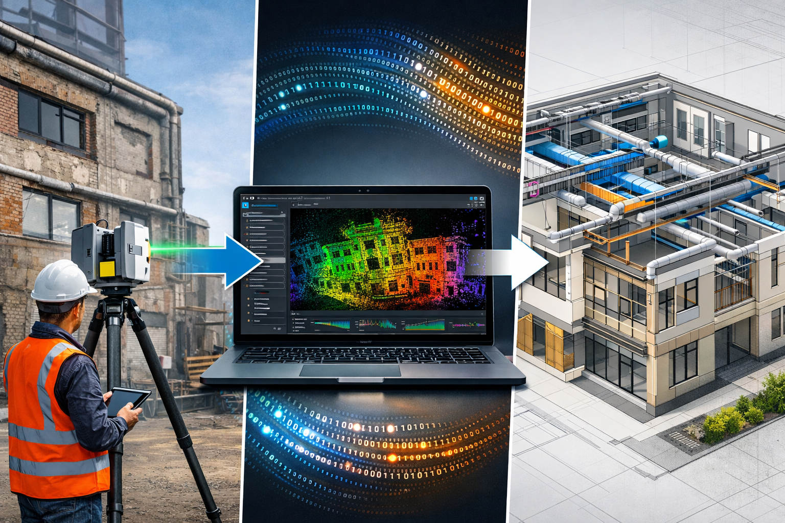
Capturing millions of points is only the first step. The true value of 3D Laser Scanning Mastery: Boosting Accuracy in Modern Property Surveys emerges when raw point cloud data is transformed into Building Information Models (BIM) that support design, construction, and facility management workflows.
This transformation process involves several stages:
Point Cloud Processing
- Registration: Aligning multiple scans into a unified coordinate system
- Cleaning: Removing noise, outliers, and unwanted objects (temporary equipment, people)
- Classification: Identifying and labeling different element types (walls, floors, ceilings, MEP systems)
- Segmentation: Separating the point cloud into discrete objects or surfaces
Model Extraction
- Automated feature recognition: AI-powered algorithms identify building elements from point cloud geometry
- Manual modeling: Skilled technicians create BIM objects (walls, beams, columns) fitted to point cloud surfaces
- Hybrid approach: Combining automated extraction with manual refinement for optimal accuracy-efficiency balance
Quality Verification
- Deviation analysis: Comparing the finished BIM model back to the source point cloud to verify accuracy
- Tolerance reporting: Documenting where modeled elements deviate from as-built conditions
- Acceptance criteria: Ensuring the model meets project-specific accuracy requirements
Practical Applications in Construction Projects
The integration of laser scanning with BIM delivers measurable benefits throughout the construction project lifecycle:
Pre-Construction Phase
- Existing conditions documentation provides accurate baseline data for renovation and adaptive reuse projects
- Constraint identification reveals spatial conflicts, structural limitations, and site-specific challenges before design begins
- Feasibility analysis enables rapid evaluation of multiple design alternatives against actual site conditions
Design Development
- Clash detection identifies conflicts between new design elements and existing structures before construction
- Design validation verifies that proposed systems fit within available space
- Coordination facilitates collaboration between architectural, structural, and MEP disciplines
A recent example highlights this value: in February 2026, LNE Surveys announced expanded 3D modeling services specifically targeting existing commercial properties. Their approach produces accurate as-built models that help project teams visualize spaces, identify constraints early, and eliminate costly rework during construction[3].
Construction Phase
- Progress monitoring compares as-built conditions against design intent at regular intervals
- Quality control verifies installation accuracy of critical building systems
- Change documentation captures field modifications for as-built record creation
Post-Construction and Facility Management
- As-built records provide accurate documentation for future renovations and maintenance
- Space management supports efficient allocation and utilization of building areas
- Asset tracking maintains inventory of building systems and equipment locations
Software Ecosystem for Scan-to-BIM Workflows
The 2026 technology stack for 3D Laser Scanning Mastery: Boosting Accuracy in Modern Property Surveys includes specialized software at each stage:
| Workflow Stage | Software Category | Leading Solutions | Primary Function |
|---|---|---|---|
| Field Capture | Scanner Control | Manufacturer apps (Leica Cyclone FIELD 360, FARO Scene) | Real-time scan management and quality preview |
| Registration | Point Cloud Processing | Autodesk ReCap, Leica Cyclone REGISTER 360 | Multi-scan alignment and georeferencing |
| Modeling | Scan-to-BIM | Autodesk Revit, ArchiCAD, Tekla Structures | BIM object creation from point clouds |
| Analysis | Deviation Analysis | CloudCompare, Geomagic Control X | Quality verification and tolerance reporting |
| Collaboration | Cloud Platforms | Autodesk BIM 360, Trimble Connect | Multi-stakeholder data sharing and coordination |
This integrated ecosystem enables seamless data flow from field capture through final deliverable production, with AI-powered automation increasingly handling routine tasks while human expertise focuses on quality control and decision-making[5].
Step-by-Step Best Practices for Property Survey Excellence
Pre-Survey Planning and Preparation
Success in 3D Laser Scanning Mastery: Boosting Accuracy in Modern Property Surveys begins long before arriving on site. Thorough planning ensures efficient data capture and fit-for-purpose deliverables.
Define Project Requirements
- Accuracy specifications: Determine required precision based on intended use (5 mm for general documentation, 2 mm for structural analysis, sub-millimeter for deformation monitoring)
- Deliverable format: Specify whether clients need point clouds, 2D CAD drawings, 3D BIM models, or combinations
- Coverage extent: Clarify which areas require documentation and at what level of detail
- Coordinate system: Establish georeferencing requirements and datum specifications
Site Reconnaissance
- Access assessment: Identify entry points, restricted areas, and access limitations
- Safety evaluation: Note hazards requiring special precautions or structural engineer consultation
- Environmental conditions: Consider lighting, weather, and temperature factors affecting equipment performance
- Scan position planning: Identify optimal scanner locations for complete coverage with minimal setups
Equipment Selection
- Scanner type: Choose between static TLS, mobile SLAM, or hybrid approach based on project requirements
- Accessories: Prepare targets, tripods, batteries, and backup equipment
- Safety gear: Ensure appropriate PPE for site conditions
- Documentation tools: Bring cameras, measurement tools, and field notes for supplementary information
Field Data Capture Methodology
Efficient field execution minimizes site time while ensuring complete, high-quality data capture.
Static TLS Scanning Protocol
- Establish control network: Position scanners at planned locations with consideration for overlap between adjacent scans (typically 30-40% overlap)
- Target placement: Distribute reference targets (spheres or checkerboards) visible from multiple scan positions to facilitate registration
- Scanner setup: Level and position each scanner, verify settings (resolution, quality, color capture)
- Scan execution: Initiate scan and monitor progress, noting any issues or deviations from plan
- Quality verification: Review scan preview for completeness before moving to next position
Mobile SLAM Scanning Protocol
- Initialization: Begin mobile scan from a static scan position or known control point to establish reference
- Path planning: Follow planned routes that create closed loops (returning to starting point) to minimize drift accumulation
- Speed management: Maintain consistent walking pace (typically 0.5-1.0 m/s) adjusted for environment complexity
- Feature awareness: Monitor real-time confidence display and slow down or add extra passes in feature-poor areas
- Loop closure: Return to starting position or connect to another control point to enable drift correction
Hybrid Workflow Execution
- Control first: Complete all static TLS scans to establish precision backbone
- Mobile infill: Use mobile scanner to rapidly capture areas between static positions
- Overlap verification: Ensure adequate overlap between static and mobile datasets for robust registration
- Real-time review: Check coverage completeness and data quality before demobilizing
Post-Processing and Quality Control
Office processing transforms raw field data into accurate, usable deliverables.
Point Cloud Registration
- Import all scans into registration software
- Automatically detect targets or use cloud-to-cloud alignment algorithms
- Review registration quality metrics (typically target RMSE < 3 mm for survey-grade work)
- Manually refine problematic alignments if necessary
- Export unified, georeferenced point cloud
Data Cleaning and Optimization
- Remove temporary objects, vehicles, and personnel captured during scanning
- Eliminate noise and outlier points using statistical filters
- Downsample data to appropriate density for intended use (balance detail versus file size)
- Classify points by type (ground, building, vegetation) if required
Model Creation and Validation
- Import point cloud into BIM software
- Create building elements fitted to point cloud surfaces
- Verify model accuracy through deviation analysis
- Document areas where as-built conditions differ from design intent
- Generate required deliverables (drawings, models, reports)
Quality Assurance Checklist
✅ All required areas captured with specified coverage
✅ Point cloud accuracy meets project specifications
✅ Registration errors within acceptable tolerances
✅ BIM model deviations documented and within tolerance
✅ Deliverables formatted per client requirements
✅ Metadata and documentation complete
Cost-Benefit Analysis and Project Efficiency Gains
Quantifiable Time and Cost Reductions
The adoption of 3D Laser Scanning Mastery: Boosting Accuracy in Modern Property Surveys delivers measurable improvements across multiple project dimensions.
Field Time Reduction
Traditional surveying of a 50,000 square foot commercial building might require 5-10 days of field work with a team of 2-3 surveyors. The same building can be comprehensively documented using hybrid laser scanning in 4-8 hours with a single operator[2]. This represents an 80-90% reduction in field time.
Processing Efficiency
Modern registration software with automated alignment algorithms reduces office processing time from days to hours. Auto-calibration features minimize the need for field return visits to resolve data gaps or quality issues—a common occurrence with traditional methods that can add days or weeks to project schedules[2].
Rework Elimination
Accurate as-built documentation prevents costly design errors and field conflicts. Studies indicate that early clash detection through scan-to-BIM workflows can reduce rework costs by 15-30% on renovation and retrofit projects[3]. For a $5 million project, this represents potential savings of $750,000 to $1.5 million.
Reduced Manpower Requirements
Laser scanning enables a single skilled operator to accomplish what previously required a full survey crew. This reduction in labor costs often offsets equipment investment within the first few projects, particularly for firms with steady survey workloads.
Safety Improvements and Risk Mitigation
Beyond direct cost savings, laser scanning delivers significant safety benefits that reduce liability exposure and insurance costs[4]:
- Distance from hazards: Operators can capture data from dangerous structures, active roadways, or unstable areas while maintaining safe distances
- Reduced site exposure: Compressed field time means less exposure to traffic, weather, and other site hazards
- Virtual surveying: Complete documentation enables detailed analysis and planning from the office, minimizing need for repeated site visits
- Hazardous environment access: Robotic and autonomous scanners document areas too dangerous for human access
For projects involving drone roof surveys or other elevated work, the ability to capture comprehensive data without physical access to dangerous locations represents a transformative safety improvement.
Return on Investment Considerations
For surveying firms considering investment in laser scanning technology, typical ROI analysis includes:
Initial Investment
- Static TLS system: $50,000-$150,000
- Mobile SLAM system: $30,000-$100,000
- Processing software licenses: $5,000-$15,000 annually
- Training and certification: $2,000-$5,000 per operator
Ongoing Costs
- Equipment maintenance and calibration: 5-10% of purchase price annually
- Software subscriptions and updates
- Continued training on new features and workflows
Revenue Opportunities
- Premium pricing for scan-based deliverables (typically 20-40% higher than traditional surveys)
- Expanded service offerings (as-built BIM, facility management, monitoring)
- Faster project turnaround enabling higher project volume
- Competitive advantage in securing complex projects
Most firms report achieving positive ROI within 12-24 months of deployment, with ongoing benefits compounding as staff expertise grows and workflows optimize.
Regulatory Framework and Industry Standards in 2026
ALTA/NSPS Guidelines Update
The surveying industry operates within a framework of professional standards that ensure consistency and quality. The 2026 ALTA/NSPS Land Title Survey Requirements (11th edition) took effect on February 23, 2026, incorporating updates that reflect the industry's adoption of advanced capture technologies[8].
Key changes relevant to laser scanning include:
- Updated optional survey items that recognize 3D data capture capabilities
- Clarified accuracy standards for surveys utilizing LiDAR and photogrammetric methods
- Enhanced deliverable specifications accommodating point cloud and 3D model formats
- Technology-neutral language that focuses on required outcomes rather than prescribing specific methods
These updates acknowledge that modern surveying increasingly relies on integrated technology stacks combining LiDAR mapping, 3D laser scanning, GNSS RTK systems, UAV photogrammetry, and mobile mapping systems[5]. The standards emphasize accuracy verification and quality documentation regardless of capture method.
Professional Certification and Competency
As laser scanning becomes standard practice, professional development requirements evolve accordingly. Chartered surveyors in 2026 increasingly pursue specialized certifications demonstrating competency in:
- Point cloud acquisition and quality control procedures
- Registration and georeferencing methodologies
- Scan-to-BIM modeling workflows and accuracy verification
- Deviation analysis and tolerance reporting
- Equipment calibration and performance verification
Professional organizations including RICS (Royal Institution of Chartered Surveyors) and NSPS (National Society of Professional Surveyors) offer training programs and certification pathways specific to laser scanning applications in property surveying.
Data Management and Privacy Considerations
The comprehensive nature of laser scanning data raises important considerations around data security and privacy protection:
- Sensitive information capture: Point clouds may inadvertently document proprietary equipment, security systems, or private spaces
- Data storage requirements: Large point cloud datasets (often 100+ GB per project) require robust storage infrastructure
- Long-term archival: As-built records must be maintained for years or decades, requiring data format migration strategies
- Access control: Limiting data distribution to authorized project stakeholders
- Regulatory compliance: Adhering to data protection regulations (GDPR, local privacy laws)
Professional surveying firms establish clear data management protocols addressing these concerns, often including client agreements specifying data ownership, usage rights, and retention policies.
Advanced Applications and Emerging Use Cases
Structural Monitoring and Deformation Analysis
One of the most powerful applications of 3D Laser Scanning Mastery: Boosting Accuracy in Modern Property Surveys is time-series monitoring to detect structural movement or deformation over time.
This workflow involves:
- Baseline scan: Capture initial conditions with high-precision static TLS
- Periodic rescanning: Return at specified intervals (monthly, quarterly, annually) to capture updated conditions
- Change detection: Compare successive scans to identify areas of movement
- Deformation quantification: Calculate magnitude and direction of detected changes
- Trend analysis: Track movement patterns over time to predict future behavior
Applications include:
- Foundation settlement monitoring for buildings on problematic soils
- Historic structure preservation tracking movement in heritage buildings
- Excavation monitoring verifying that adjacent structures remain stable during nearby construction
- Dam and bridge safety detecting deformation indicating structural distress
For properties requiring subsidence surveys, laser scanning provides objective, comprehensive documentation of vertical movement patterns that traditional leveling surveys might miss.
Facility Management and Space Planning
Beyond initial construction documentation, laser scanning supports ongoing facility management by creating accurate digital records of building spaces and systems.
Facility managers use scan-derived BIM models for:
- Space utilization analysis: Measuring actual versus allocated space to optimize usage
- Move planning: Visualizing furniture and equipment arrangements before physical changes
- Maintenance access: Identifying access routes to mechanical systems and equipment
- Renovation planning: Providing accurate existing conditions for tenant improvement projects
- Asset inventory: Maintaining spatial database of equipment locations and specifications
Cloud-based platforms enable facility managers to access these models from mobile devices while on-site, improving efficiency of inspections and maintenance activities.
Heritage Documentation and Digital Preservation
Laser scanning plays a crucial role in cultural heritage preservation, creating permanent digital records of historically significant structures.
Benefits for heritage applications include:
- Non-contact measurement: Documenting fragile structures without physical contact that might cause damage
- Complete geometric capture: Recording intricate architectural details and ornamentation
- Condition assessment: Identifying areas of deterioration requiring conservation
- Virtual access: Enabling researchers and public to study structures remotely
- Disaster recovery: Providing data for accurate reconstruction if structures are damaged
The millimeter-level accuracy of modern scanners captures subtle details that photographs alone cannot preserve, creating invaluable archives for future generations.
Integration with Other Survey Technologies
3D Laser Scanning Mastery: Boosting Accuracy in Modern Property Surveys increasingly involves multi-sensor integration combining complementary technologies:
Aerial LiDAR and Photogrammetry
- UAV-mounted laser scanners capture roof areas and site context
- Aerial photogrammetry provides high-resolution imagery for texture mapping
- Combined with terrestrial scans for complete property documentation
Ground Penetrating Radar (GPR)
- Subsurface utility mapping integrated with above-ground laser scans
- Comprehensive documentation of visible and buried infrastructure
- Critical for renovation projects requiring utility coordination
Thermal Imaging
- Infrared cameras capture thermal data aligned with geometric point clouds
- Building envelope analysis identifying insulation deficiencies
- Energy audit applications combining spatial and thermal information
Total Station Integration
- Traditional survey instruments establish geodetic control networks
- Laser scans registered to survey control for absolute positional accuracy
- Hybrid workflows combining conventional and scanning methods
This multi-sensor approach delivers comprehensive property intelligence that no single technology can provide alone, supporting informed decision-making across the project lifecycle.
Choosing the Right Survey Approach for Your Project
When to Deploy Laser Scanning
While laser scanning offers numerous advantages, it's not always the optimal choice for every surveying application. Understanding when scanning adds value helps ensure cost-effective project execution.
Ideal Laser Scanning Applications
- Complex geometries with numerous irregular surfaces
- Large areas requiring comprehensive documentation
- Projects requiring high point density and detail
- Time-sensitive surveys with compressed schedules
- Hazardous or difficult-to-access locations
- As-built documentation for BIM integration
- Monitoring applications requiring repeat surveys
Traditional Methods May Suffice
- Simple rectangular spaces with few details
- Projects requiring only boundary or property line surveys
- Applications where 2D drawings fully meet needs
- Very small areas where setup time exceeds scanning efficiency
- Budget-constrained projects where scanning premium isn't justified
Many projects benefit from hybrid approaches combining laser scanning for complex areas with traditional methods for simpler elements. For example, a boundary survey might use conventional methods for property line establishment while deploying scanning to document structures and improvements.
Selecting Qualified Survey Professionals
The sophistication of modern laser scanning technology makes professional expertise more important than ever. When engaging surveying services, consider:
Technical Competency
- Experience with specific scanner types and software platforms
- Portfolio of similar projects demonstrating relevant expertise
- Professional certifications in laser scanning and point cloud processing
- Understanding of accuracy requirements and quality control procedures
Project Management Capability
- Clear communication of deliverable specifications and timelines
- Transparent pricing and scope definition
- Established quality assurance protocols
- Responsive to questions and concerns throughout project
Technology Infrastructure
- Current-generation scanning equipment properly maintained and calibrated
- Robust data processing and storage capabilities
- Appropriate software licenses and technical support
- Backup equipment and contingency planning
Professional Standing
- Licensed professional surveyors with good standing
- Professional liability insurance adequate for project scope
- Positive client references and testimonials
- Membership in relevant professional organizations
For complex projects, consider requesting a technical proposal detailing the specific methodology, equipment, accuracy expectations, and quality control procedures the surveyor will employ.
Understanding Deliverable Options
Laser scanning projects can produce various deliverable formats depending on project needs. Common options include:
Point Cloud Deliverables
- Raw point clouds: Unprocessed scan data in native scanner format
- Registered point clouds: Multiple scans aligned into unified coordinate system
- Cleaned and classified point clouds: Processed data with noise removed and points categorized
- Web-viewable point clouds: Browser-based viewers enabling stakeholder access without specialized software
2D Drawing Deliverables
- Floor plans: Horizontal sections extracted from point cloud data
- Elevations: Vertical projections showing facade details
- Sections: Cut-through views revealing internal relationships
- Details: Enlarged views of specific features or connections
3D Model Deliverables
- BIM models: Intelligent 3D models in Revit, ArchiCAD, or similar platforms
- Mesh models: Triangulated surface models for visualization
- CAD models: 3D solid or surface models in AutoCAD or similar
- Reality mesh: Photo-textured mesh combining geometry and imagery
Analysis Deliverables
- Deviation reports: Documenting differences between as-built and design
- Volume calculations: Measuring quantities for materials or excavation
- Deformation analysis: Tracking structural movement over time
- Clearance verification: Confirming adequate space for equipment or systems
Clearly defining required deliverables at project outset ensures the survey approach and processing workflow align with end-use requirements. For projects requiring expert witness reports, documentation standards and accuracy verification become particularly critical.
Future Trends and Continuing Evolution
Artificial Intelligence and Machine Learning Integration
The next frontier in 3D Laser Scanning Mastery: Boosting Accuracy in Modern Property Surveys involves AI-powered automation that accelerates processing and extracts intelligence from point cloud data[5].
Emerging AI applications include:
Automated Feature Recognition
- Machine learning algorithms trained to identify building elements (walls, doors, windows, columns)
- Automatic BIM object creation with minimal manual intervention
- Classification of MEP systems and equipment from point cloud geometry
- Damage and defect detection for condition assessment applications
Intelligent Data Cleaning
- AI-powered noise filtering that preserves genuine detail while removing artifacts
- Automatic identification and removal of temporary objects
- Smart segmentation separating building from surroundings
Predictive Quality Control
- Real-time assessment of scan quality and coverage completeness
- Predictive modeling of registration accuracy before processing
- Automated identification of data gaps requiring additional capture
Enhanced Change Detection
- Intelligent comparison of time-series scans identifying significant changes
- Filtering out insignificant variations (furniture movement, temporary items)
- Automated progress monitoring comparing construction to schedule
These AI capabilities are rapidly transitioning from research laboratories to commercial software platforms, promising continued productivity improvements in coming years.
Sensor Technology Advancements
Hardware innovation continues to push the boundaries of speed, accuracy, and portability:
Increased Point Capture Rates
- Next-generation scanners achieving 2-5 million points per second
- Reduced scan times while maintaining or improving accuracy
- Enhanced productivity for large-scale projects
Miniaturization and Integration
- Smartphone-integrated LiDAR becoming survey-capable
- Wearable scanners with reduced weight and improved ergonomics
- Multi-sensor devices combining scanning, imaging, and positioning
Extended Range and Accuracy
- Long-range scanners exceeding 1 km measurement distance
- Improved accuracy specifications approaching sub-millimeter performance
- Enhanced performance in challenging conditions (bright sunlight, reflective surfaces)
Autonomous Operation
- Self-positioning scanners using robotic platforms
- Automated scan planning and execution
- Continuous monitoring applications with minimal human intervention
Expanding Applications and Market Adoption
As technology matures and costs decrease, laser scanning adoption expands into new market segments:
Residential Applications
- Pre-purchase property surveys offering detailed documentation
- Renovation planning for homeowners and small contractors
- Snagging reports using scan data for new construction quality verification
- Home insurance documentation and claims support
Small-Scale Commercial
- Retail space planning and tenant improvement documentation
- Restaurant and hospitality renovation projects
- Small office fit-out and reconfiguration
- Property condition assessments for lease negotiations
Infrastructure and Transportation
- Highway and railway corridor documentation
- Bridge and tunnel inspection and monitoring
- Airport and transit facility management
- Utility corridor mapping and clearance verification
Environmental and Natural Resources
- Coastal erosion monitoring and flood modeling
- Forest inventory and biomass assessment
- Mining and quarry volume calculations
- Archaeological site documentation
This market expansion drives continued technology development, creating a virtuous cycle of improvement and adoption.
Conclusion: Embracing the Future of Property Surveying
3D Laser Scanning Mastery: Boosting Accuracy in Modern Property Surveys represents far more than a technological upgrade—it constitutes a fundamental transformation in how the surveying profession captures, analyzes, and communicates spatial information. The convergence of terrestrial laser scanning, mobile SLAM technology, BIM integration, and AI-powered processing has created an ecosystem that delivers unprecedented accuracy, efficiency, and value across the property development lifecycle.
The evidence is compelling: hybrid workflows combining static precision with mobile speed achieve optimized accuracy of 3-5 mm while reducing field time by up to 80%[1]. Real-time quality monitoring eliminates costly return visits[2]. BIM integration transforms raw data into actionable intelligence that prevents design conflicts and reduces rework by 15-30%[3]. Safety improvements allow comprehensive documentation of hazardous areas while keeping personnel at safe distances[4].
Actionable Next Steps
For property owners, developers, and construction professionals looking to leverage these capabilities:
1. Assess Your Project Requirements
- Identify which projects would benefit most from laser scanning (complex renovations, tight schedules, accuracy-critical applications)
- Define specific deliverable needs (point clouds, 2D drawings, 3D BIM models)
- Establish accuracy requirements based on intended use
- Consider whether you need to determine what survey you need for your specific situation
2. Engage Qualified Professionals
- Research surveying firms with demonstrated laser scanning expertise
- Request technical proposals detailing methodology and quality control
- Verify professional credentials, insurance, and references
- Consider working with chartered surveyors who maintain rigorous professional standards
3. Plan for Data Integration
- Ensure project teams have software and skills to utilize scan deliverables
- Establish data sharing protocols and file formats
- Define quality acceptance criteria before work begins
- Consider long-term data archival and management requirements
4. Start with Pilot Projects
- Test laser scanning on a representative project before full-scale adoption
- Evaluate time savings, accuracy improvements, and ROI
- Gather lessons learned to optimize future projects
- Build internal expertise and confidence with the technology
5. Invest in Ongoing Education
- Stay current with evolving technology and best practices
- Attend industry conferences and training programs
- Engage with professional organizations promoting scanning excellence
- Foster collaboration between surveying, design, and construction teams
The surveying industry's transformation is accelerating, not slowing. The 2026 ALTA/NSPS Guidelines update reflects regulatory recognition that advanced capture technologies are now the standard, not the exception[8]. Firms and professionals who master these capabilities position themselves at the forefront of an industry experiencing its most significant evolution in generations.
The question is no longer whether to adopt laser scanning, but how quickly to develop the expertise, workflows, and partnerships necessary to fully leverage its transformative potential. Those who embrace 3D Laser Scanning Mastery: Boosting Accuracy in Modern Property Surveys today will lead the industry tomorrow, delivering superior outcomes for clients while building sustainable competitive advantages in an increasingly technology-driven marketplace.
The future of property surveying has arrived—precise, efficient, comprehensive, and more capable than ever before. The opportunity is yours to seize. 🎯
References
[1] 3d Laser Scanning In 2026 Major Technology And Workflow Shifts – https://www.enginyring.com/en/blog/3d-laser-scanning-in-2026-major-technology-and-workflow-shifts
[2] 3d Laser Scanning New Opportunities For Surveying And Mapping Professionals – https://geospatial.trimble.com/blog/geospatial/en-US/article/3d-laser-scanning-new-opportunities-for-surveying-and-mapping-professionals
[3] Lne Surveys Provides 3d Models Improved Project Collaboration And Design – https://natlawreview.com/press-releases/lne-surveys-provides-3d-models-improved-project-collaboration-and-design
[4] 3d Laser Scanning Used In Land Surveying – https://www.duncan-parnell.com/blog/108/3d-laser-scanning-used-in-land-surveying
[5] The Future Of Land Surveying Technology And Upcoming Trends In 2026 – https://metricop.com/blogs/land-surveying/the-future-of-land-surveying-technology-and-upcoming-trends-in-2026
[8] What 2026 Alta Nsps Updates Mean For Cre Professionals – https://www.partneresi.com/resources/articles/what-2026-alta-nsps-updates-mean-for-cre-professionals/