nn

Picture this: a surveyor arrives at a sprawling urban development site, pulls a compact device from their vehicle, and within hours captures millions of precise data points across multiple city blocks. No heavy tripods. No days of painstaking measurements. No crew of assistants hauling equipment. This isn't science fiction—it's Mobile 3D Mapping: Fast-Track Your Surveys Without Bulky Gear, a revolutionary approach transforming how professionals capture spatial data in 2026.
Traditional surveying methods have served the industry well for decades, but they come with significant drawbacks: cumbersome equipment, lengthy setup times, and labor-intensive data collection processes. Mobile 3D mapping technology shatters these limitations by mounting sophisticated sensors on vehicles, enabling surveyors to collect comprehensive spatial data while moving through urban and rural environments at normal driving speeds.
The transformation is remarkable. What once required weeks of fieldwork with traditional total stations and terrestrial laser scanners can now be accomplished in days—or even hours—using vehicle-mounted systems equipped with LiDAR sensors, high-resolution cameras, and precision positioning equipment. This efficiency gain isn't just about speed; it's about fundamentally reimagining how spatial data collection integrates into modern workflows.
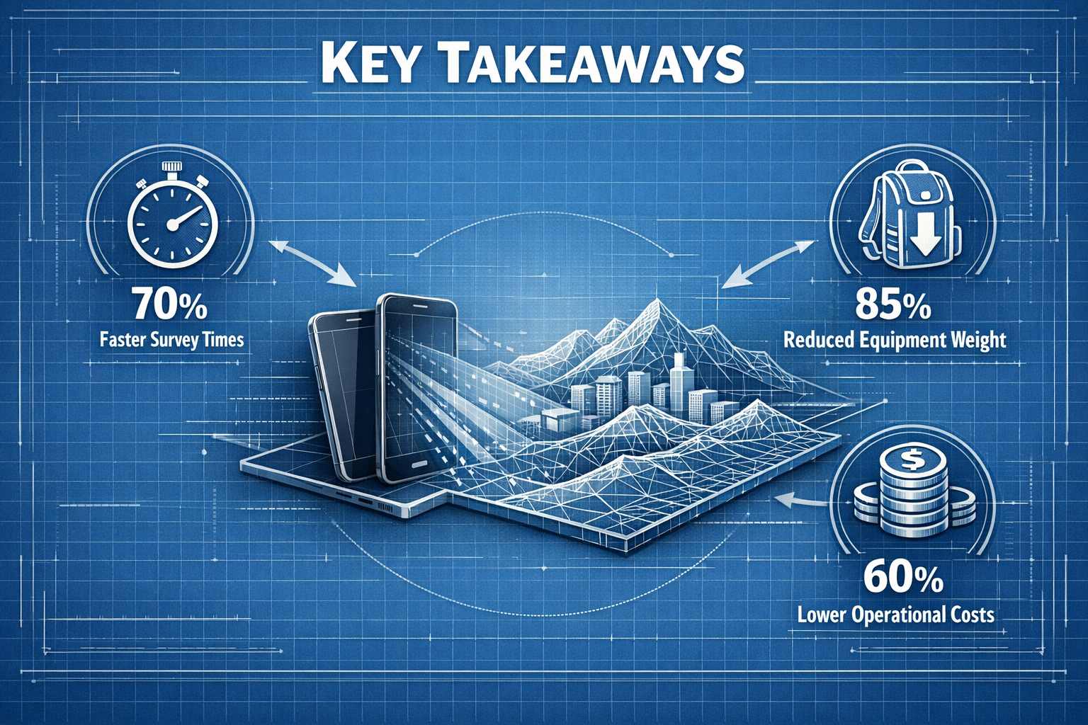
Key Takeaways
📌 Dramatic time savings: Mobile 3D mapping reduces survey times from weeks to days or hours by capturing data while vehicles move through target areas at normal speeds
📌 Compact, integrated systems: Modern mobile mapping equipment eliminates bulky traditional gear by combining LiDAR, cameras, GPS, and IMUs into streamlined vehicle-mounted packages
📌 Explosive market growth: The mobile mapping market is projected to reach $232.9 billion by 2034, expanding at 18.2% CAGR, driven by autonomous vehicles and infrastructure development[2]
📌 Multi-industry applications: From urban planning and construction monitoring to heritage preservation and asset management, mobile 3D mapping serves diverse professional needs
📌 Real-time processing capabilities: Advanced systems now offer immediate data visualization and analysis, enabling on-site decision-making without post-processing delays
Understanding Mobile 3D Mapping Technology
What Makes Mobile 3D Mapping Different
Mobile 3D mapping represents a fundamental shift in spatial data collection methodology. Unlike stationary surveying equipment that requires setup at fixed positions, mobile mapping systems continuously capture data while moving through an environment. This kinematic approach leverages vehicle mobility to cover vast areas efficiently while maintaining survey-grade accuracy.
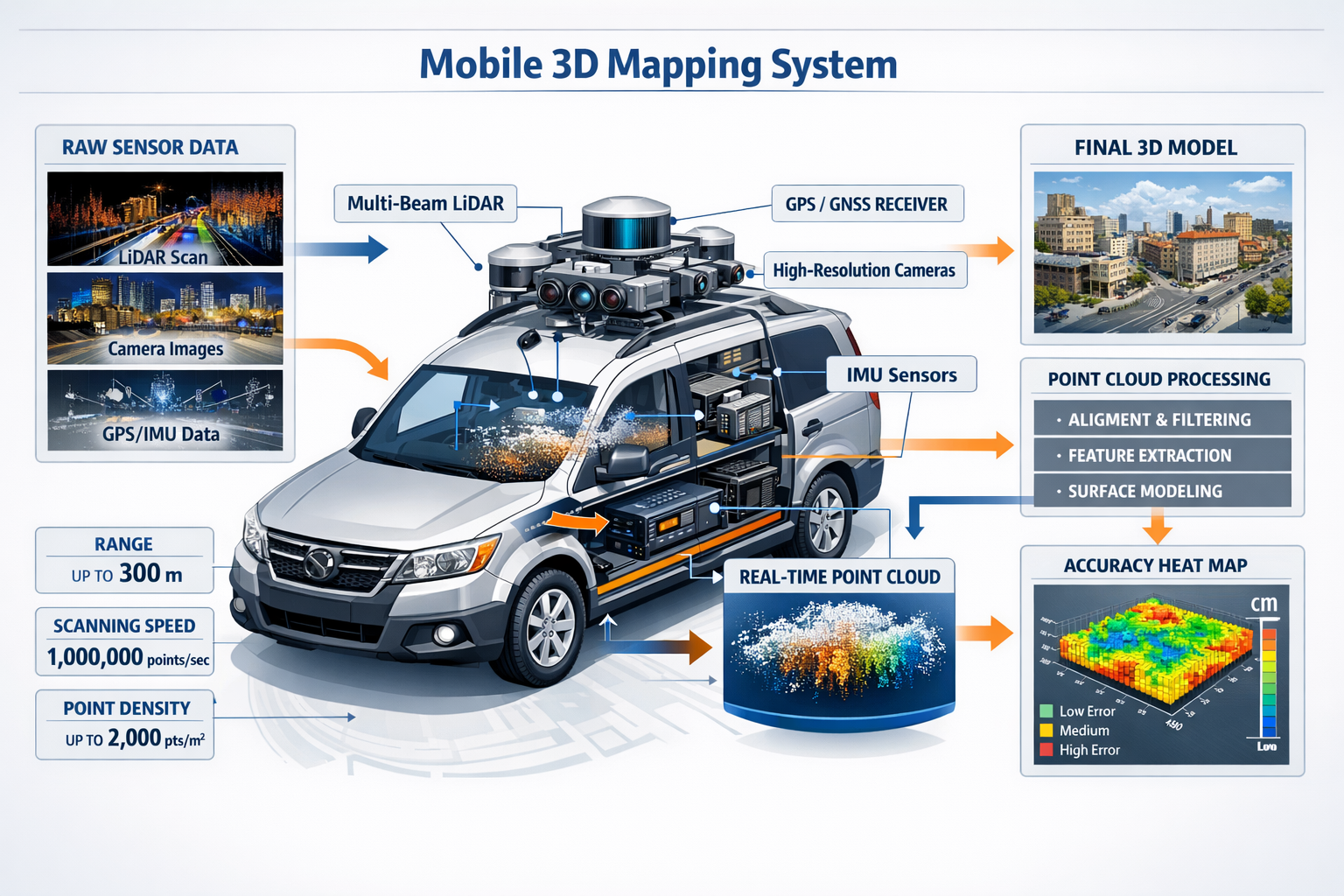
The technology combines several critical components working in perfect synchronization:
LiDAR (Light Detection and Ranging) sensors emit laser pulses that bounce off surrounding objects, measuring distances with millimeter-level precision. Modern systems like the Leica Pegasus TRK300, launched in May 2025, feature multi-beam scanners with dual scanning heads and ranges extending up to 300 meters, enabling high-quality point cloud data capture across expansive areas[2].
High-resolution cameras capture visual imagery that adds color and texture information to the geometric data collected by LiDAR. This photogrammetric component creates realistic 3D models that are both metrically accurate and visually interpretable.
GPS/GNSS receivers provide absolute positioning data, anchoring the collected information to real-world coordinates. However, satellite signals can be unreliable in urban canyons, tunnels, and forested areas—challenges addressed by innovative solutions.
Inertial Measurement Units (IMUs) track the sensor platform's orientation and movement, compensating for vehicle motion and ensuring accurate data registration even when navigating curves, hills, or rough terrain.
The integration of these technologies creates a comprehensive data collection platform that operates seamlessly while vehicles traverse roads, streets, and accessible pathways. Hardware currently dominates the mobile mapping market with a 57% share as of 2024, reflecting the critical importance of sensor quality and integration[2].
Overcoming GNSS Limitations
One of the most significant recent innovations addresses a persistent challenge: maintaining accurate positioning when satellite signals are blocked or degraded. OxTS introduced WayFinder in March 2025, a GNSS-denied localization solution that combines LiDAR sensor fusion, inertial navigation, and GNSS/INS technology[2].
This advancement enables accurate positioning in challenging environments including:
- 🏙️ Urban canyons where tall buildings block satellite signals
- 🚇 Tunnels with complete GNSS denial
- 🌲 Dense forests where tree canopy interferes with reception
- 🏗️ Indoor spaces requiring continuous positioning
By fusing multiple sensor inputs and employing sophisticated algorithms, these systems maintain centimeter-level accuracy even when traditional GPS fails. This capability dramatically expands the operational envelope for mobile mapping, making it viable for complex urban environments and infrastructure projects.
Real-Time Processing and AI Integration
The evolution from post-processing to real-time data visualization represents another transformative development. Advanced mobile mapping systems in 2026 can now display collected point clouds and preliminary 3D models immediately during data collection, enabling operators to identify coverage gaps and quality issues while still in the field.
Generative AI integration is revolutionizing how captured data gets processed and analyzed. Artificial intelligence algorithms now automate:
- Point cloud classification (identifying ground, vegetation, buildings, infrastructure)
- Feature extraction (detecting road markings, signs, utilities, assets)
- Anomaly detection (identifying defects, damage, or unexpected objects)
- Real-time map updates from large geospatial datasets[2]
These AI-powered capabilities significantly reduce processing times and enable applications that would be impractical with manual workflows. For professionals conducting structural surveys or specific defect reports, this means faster turnaround times and more comprehensive analysis.
Mobile 3D Mapping vs Traditional Survey Methods: A Comprehensive Comparison
Equipment Portability and Setup Requirements
The contrast between traditional and mobile approaches becomes immediately apparent when examining equipment logistics:
| Aspect | Traditional Surveying | Mobile 3D Mapping |
|---|---|---|
| Equipment Weight | 50-100+ lbs (total station, tripod, accessories) | 30-60 lbs (integrated sensor head) |
| Setup Time | 15-30 minutes per station | 5-10 minutes for entire system |
| Crew Size | 2-3 people typically required | 1-2 people sufficient |
| Transportation | Multiple cases, dedicated vehicle space | Roof-mounted or integrated system |
| Weather Sensitivity | High (extended outdoor exposure) | Moderate (continuous movement) |
Traditional total stations and terrestrial laser scanners deliver exceptional accuracy but demand significant setup effort at each measurement position. Surveyors must carefully level instruments, establish control points, and methodically move between stations to achieve comprehensive coverage.
Mobile mapping systems eliminate these repetitive setup procedures. Once mounted on a vehicle and calibrated, the system operates continuously during data collection runs. This streamlined workflow translates directly into labor cost savings and project timeline compression.
Data Collection Speed and Coverage
The efficiency advantages of mobile 3D mapping become even more pronounced when examining collection rates:
Traditional terrestrial laser scanning might capture 500,000 to 1 million points per second from a stationary position, requiring 10-20 minutes per scan location. Covering a kilometer of urban streetscape could necessitate 20-40 scan positions, consuming an entire day or more.
Mobile mapping systems capture similar point densities while moving at 30-50 km/h (20-30 mph), collecting data across entire corridors in single passes. A system can survey 50-100 kilometers of roadway in a typical workday, gathering comprehensive spatial data about the road surface, adjacent infrastructure, building facades, and surrounding environment.
This speed advantage proves particularly valuable for:
- 🛣️ Transportation corridor mapping requiring extensive linear coverage
- 🏘️ Urban planning projects encompassing multiple city blocks
- 🏗️ Construction progress monitoring across large development sites
- 🏛️ Heritage documentation of historic districts or archaeological sites
For professionals managing commercial dilapidation surveys or conducting schedule of dilapidations assessments, mobile mapping enables comprehensive baseline documentation in a fraction of traditional timeframes.
Accuracy and Data Quality Considerations
A common misconception suggests that mobile mapping sacrifices accuracy for speed. While traditional static surveying can achieve sub-millimeter precision under controlled conditions, modern mobile systems deliver accuracy levels entirely adequate for most professional applications:
Absolute positioning accuracy: 2-5 cm with high-quality GNSS/INS integration
Relative accuracy: 1-2 cm within local project areas
Point cloud density: 100-500 points per square meter at typical collection speeds
These specifications meet or exceed requirements for applications including:
- Topographic mapping and terrain modeling
- Building facade documentation
- Infrastructure asset inventory
- Construction site as-built verification
- Urban planning and development
For applications demanding higher precision—such as detailed structural deformation monitoring or precision machine control—hybrid approaches combining mobile mapping for general coverage with targeted static scanning for critical features often provide optimal results.
Cost-Benefit Analysis
The financial case for mobile 3D mapping extends beyond equipment costs to encompass total project economics:
Initial Investment:
- Traditional surveying equipment: $20,000-$50,000 (total station and accessories)
- Terrestrial laser scanner: $50,000-$150,000
- Mobile mapping system: $100,000-$400,000 (depending on sensor configuration)
While mobile systems require higher upfront investment, the return on investment materializes through:
✅ Reduced field time: 50-80% fewer person-hours for data collection
✅ Lower labor costs: Smaller crews and faster project completion
✅ Increased project capacity: Ability to handle more assignments with same resources
✅ Enhanced safety: Less time exposed to traffic or hazardous environments
✅ Comprehensive documentation: Richer datasets supporting multiple analyses
For surveying firms and chartered surveyors handling regular mapping assignments, mobile systems typically achieve payback within 12-24 months through efficiency gains and expanded service offerings.
Practical Applications: Mobile 3D Mapping Across Industries
Urban Planning and Smart City Development
Municipal authorities and urban planners increasingly rely on mobile 3D mapping to create digital twins of entire cities—comprehensive virtual replicas that support planning, simulation, and management activities. The 3D mapping and modeling market, valued at $6.92 billion in 2025, is projected to expand to $20.45 billion by 2033, representing a compound annual growth rate of 14.5%[4].
Mobile mapping enables cities to:
Inventory municipal assets including street lights, traffic signals, signs, fire hydrants, and utility infrastructure with precise locations and conditions documented in comprehensive databases.
Plan infrastructure improvements by analyzing existing conditions, identifying conflicts, and simulating proposed changes within accurate 3D environments before committing to construction.
Monitor urban development through periodic resurveys that document changes, track construction progress, and verify compliance with approved plans.
Support emergency response with detailed 3D models that help first responders navigate complex environments and plan interventions.
The ability to capture comprehensive citywide data efficiently makes mobile mapping indispensable for modern urban management. Cities can now maintain current spatial inventories that would be prohibitively expensive using traditional methods.
Transportation Infrastructure and Highway Surveys
Transportation agencies represent one of the largest user groups for mobile mapping technology. Highway departments use these systems to:
- 📏 Document pavement conditions with millimeter-level surface profiles identifying rutting, cracking, and deterioration
- 🚦 Inventory roadside assets cataloging signs, barriers, drainage structures, and vegetation
- 🛤️ Design improvements using accurate as-built data for alignment studies and reconstruction projects
- ⚠️ Assess clearances verifying vertical and horizontal clearances for bridges and structures
- 📊 Support asset management with condition data feeding pavement management systems
The linear nature of transportation corridors perfectly matches mobile mapping's strengths. A single survey run captures comprehensive data about the roadway and surrounding environment, supporting multiple engineering analyses from one dataset.
Construction and Development Projects
Construction professionals leverage mobile 3D mapping throughout project lifecycles:
Pre-construction phase: Site surveys capture existing conditions for design development and quantity estimation, replacing weeks of traditional surveying with days of mobile data collection.
During construction: Regular progress monitoring compares as-built conditions against design models, identifying deviations early when corrections are less costly. This application aligns well with snagging report requirements for quality verification.
Project completion: Final as-built documentation creates permanent records of completed work, supporting facility management and future modifications.
The construction industry's growing adoption of Building Information Modeling (BIM) workflows creates natural synergy with mobile mapping. Point cloud data integrates directly into BIM software, enabling reality capture that feeds design and coordination processes.
Heritage Preservation and Archaeological Documentation
Cultural heritage professionals use mobile mapping to document historic structures, archaeological sites, and culturally significant landscapes. The technology offers particular advantages for:
🏛️ Large historic districts where comprehensive documentation would be impractical with traditional methods
⏱️ Time-sensitive recording of threatened sites requiring rapid documentation
🎨 Public engagement through detailed 3D models that support virtual tours and educational programs
📚 Archival preservation creating permanent digital records protecting against loss or damage
Mobile mapping complements terrestrial scanning for heritage applications. Systems capture street-level context and building exteriors efficiently, while static scanning addresses interior spaces and detailed architectural features requiring higher resolution.
Property and Boundary Surveys
While mobile mapping doesn't replace traditional boundary surveys requiring legal-grade precision, it supports property-related applications including:
- Property condition documentation for dilapidation surveys
- Site analysis for development feasibility studies
- Environmental assessments and topographic mapping
- Schedule of condition reports documenting pre-construction baselines
For professionals conducting party wall matters assessments or addressing neighbour disputes, mobile mapping provides objective spatial documentation that can support negotiations and resolutions.
Step-by-Step Tutorial: Conducting Your First Mobile 3D Mapping Survey
Phase 1: Planning and Preparation
Define project objectives and requirements
Begin by clearly articulating what you need to accomplish. Are you documenting existing conditions for design? Creating an asset inventory? Monitoring construction progress? Your objectives determine sensor requirements, data density specifications, and collection parameters.
Assess site conditions and access
Conduct reconnaissance to identify:
- Accessible routes providing adequate coverage of target areas
- Potential GNSS-denied zones requiring special attention
- Traffic patterns and timing for safe data collection
- Parking areas for equipment setup and calibration
Establish control network
Even mobile mapping benefits from ground control points—surveyed locations with known coordinates that enable system calibration verification and accuracy assessment. Establish 3-5 control points distributed throughout the project area using conventional surveying methods.
Obtain necessary permits and permissions
Coordinate with property owners, municipalities, or agencies to secure access permissions. Some jurisdictions require permits for survey activities on public roads or in sensitive areas.
Phase 2: System Setup and Calibration
Mount and secure sensors
Properly install the mobile mapping system on your vehicle following manufacturer specifications. Ensure:
- Secure mounting preventing vibration or movement
- Unobstructed sensor fields of view
- Proper cable routing and connections
- Power supply adequacy for planned survey duration
Initialize positioning systems
Power up GPS/GNSS receivers and allow adequate time for satellite acquisition and initialization. Modern systems typically require 5-15 minutes to achieve optimal positioning accuracy.
Perform system calibration
Execute calibration routines that establish precise relationships between sensors. This critical step ensures that data from LiDAR, cameras, and positioning systems align correctly. Most systems require:
- Static initialization period
- Figure-eight or calibration drive pattern
- Verification against known control points
Configure collection parameters
Set scanning density, camera frame rates, and other parameters appropriate for project requirements. Higher densities provide more detail but generate larger datasets requiring more processing time and storage.
Phase 3: Data Collection Execution
Drive planned routes at appropriate speeds
Execute survey runs following planned paths at speeds appropriate for your system and project requirements. Most mobile mapping systems operate optimally at:
- Urban environments: 20-40 km/h (12-25 mph)
- Highway corridors: 40-70 km/h (25-45 mph)
- Complex areas: 10-20 km/h (6-12 mph)
Monitor data quality in real-time
Modern systems display collection status during surveys. Watch for:
- ✅ Adequate satellite coverage and positioning quality
- ✅ Proper sensor operation and data recording
- ✅ Coverage of target features without gaps
- ✅ System warnings or error messages
Execute multiple passes if needed
For comprehensive coverage, plan overlapping passes from different directions. This approach:
- Captures features obscured from single viewpoints
- Provides redundant data improving accuracy
- Ensures complete coverage of complex areas
Document collection conditions
Record environmental factors affecting data quality:
- Weather conditions (precipitation, fog, lighting)
- Traffic density and flow patterns
- System performance notes
- Any anomalies or issues encountered
Phase 4: Data Processing and Deliverable Creation
Transfer and organize raw data
Download collected data from the mobile system to processing workstations. Organize files systematically by date, location, or project phase to facilitate efficient processing.
Process positioning and trajectory data
Compute final vehicle trajectories using post-processing software that combines GNSS observations with IMU data and, when available, base station corrections. This step refines positioning accuracy beyond real-time solutions.
Generate point clouds
Process LiDAR data to create georeferenced point clouds. Modern software automates much of this workflow, though quality control reviews remain essential. AI-powered classification tools can automatically identify:
- Ground surfaces
- Vegetation
- Buildings and structures
- Infrastructure elements
Create derivative products
Transform raw point clouds into deliverables matching client requirements:
- 📐 CAD drawings showing plan and profile views
- 🗺️ Digital terrain models representing ground surfaces
- 🏗️ 3D mesh models with photorealistic textures
- 📊 Asset inventories with locations and attributes
- 📈 Analysis reports documenting findings
Perform quality assurance
Verify deliverable accuracy by comparing processed data against control points and conducting visual inspections for completeness and quality. Document accuracy statistics and any limitations.
Phase 5: Delivery and Archive
Package deliverables
Organize final products with clear documentation including:
- Project metadata (dates, coordinates systems, accuracy specifications)
- Processing reports
- Known limitations or data gaps
- User guides for accessing and interpreting data
Archive project data
Maintain organized archives of raw and processed data. Mobile mapping projects generate substantial data volumes—plan adequate storage with appropriate backup strategies.
Advanced Techniques and Best Practices
Optimizing Data Collection Routes
Strategic route planning maximizes efficiency and data quality:
Multiple perspective coverage: Plan passes from opposite directions to capture both sides of streets and reduce occlusions from parked vehicles or street furniture.
Overlap zones: Design routes with 20-30% overlap between adjacent passes, ensuring complete coverage and providing redundancy for quality assurance.
Speed variation: Reduce speed in complex areas requiring higher point density while maintaining higher speeds in open areas with simpler geometry.
Time-of-day considerations: Schedule collections during off-peak traffic hours for safety and efficiency. Consider sun angle for photogrammetric applications—avoid direct sunlight creating harsh shadows or lens flare.
Integrating Mobile Mapping with Other Survey Technologies
Mobile 3D mapping works best as part of an integrated toolkit:
Complement with terrestrial scanning: Use mobile mapping for general coverage and static scanning for detailed features requiring higher resolution. This hybrid approach optimizes efficiency while maintaining quality where it matters most.
Combine with drone roof surveys: Aerial data captures rooftops and areas inaccessible to ground-based systems, creating complete building models when combined with mobile mapping of facades.
Leverage conventional surveying: Establish control networks and verify critical dimensions using traditional methods, using mobile mapping for comprehensive spatial context.
Managing Large Datasets
Mobile mapping generates substantial data volumes—a single day of collection can produce hundreds of gigabytes. Effective data management requires:
💾 Adequate storage infrastructure: Plan for 500 GB to 2 TB per project day, with backup redundancy
⚡ Processing workstations: Invest in computers with powerful GPUs, abundant RAM (64+ GB), and fast storage (NVMe SSDs)
☁️ Cloud processing options: Consider cloud-based processing services that eliminate local hardware constraints for large projects
🗂️ Systematic organization: Implement consistent naming conventions and folder structures facilitating efficient data retrieval
Ensuring Accuracy and Quality Control
Maintain survey-grade quality through rigorous QC procedures:
Pre-survey calibration verification: Check system calibration against known targets before each project or weekly for ongoing work.
In-field quality monitoring: Review real-time displays during collection, repeating passes if quality indicators suggest issues.
Control point verification: Compare processed point clouds against surveyed control points, documenting accuracy statistics.
Peer review: Have experienced staff review deliverables before client delivery, checking for completeness, accuracy, and presentation quality.
Market Trends and Future Developments
Autonomous Vehicle Integration
The autonomous vehicle revolution drives substantial mobile mapping demand. Self-driving cars require high-definition maps with centimeter-level accuracy showing road geometry, lane markings, traffic signs, and surrounding environment. The mobile mapping market's projected growth to $232.9 billion by 2034 reflects this autonomous vehicle expansion[2].
Mobile mapping systems designed for autonomous vehicle development feature:
- Real-time processing for immediate map updates
- Semantic classification identifying drivable surfaces, obstacles, and landmarks
- Change detection highlighting differences from previous surveys
- Continuous operation supporting fleet-based mapping
This application drives technological advancement benefiting all mobile mapping users through improved sensors, faster processing, and enhanced automation.
Sensor Technology Evolution
Rapid advancement in sensor technologies continues expanding mobile mapping capabilities:
Complementary metal-oxide semiconductor (CMOS) digital cameras deliver higher resolution imagery with improved dynamic range and low-light performance[3].
AI accelerators and embedded GPUs enable sophisticated processing algorithms to run in real-time during data collection, providing immediate feedback and preliminary results[3].
Single-photon and Geiger-mode LiDAR dramatically increases data collection productivity, capturing usable returns from greater distances and enabling aerial mobile mapping from aircraft and drones[3].
Multi-technology flexibility allows systems to support mix-and-match approaches, decoupling feature development from specific camera configurations[1]. This modularity enables users to upgrade individual components without replacing entire systems.
Real-Time 3D Reconstruction
Cutting-edge developments showcase real-time comprehensive digital reconstruction capabilities. Seeing Machines' 3D Cabin Perception Mapping, demonstrated at CES 2026 in January, features a "clean-sheet" architecture enabling real-time digital reconstruction from multiple cameras simultaneously[1].
While initially developed for vehicle cabin monitoring (supporting up to 7 occupants across 3 rows), the underlying technology demonstrates broader potential for mobile mapping applications. Real-time reconstruction enables:
- Immediate visualization of collected data during surveys
- On-site decision making without post-processing delays
- Interactive quality control and coverage verification
- Rapid preliminary deliverable generation
As these capabilities mature and become more accessible, the distinction between data collection and deliverable creation will blur, fundamentally transforming survey workflows.
Artificial Intelligence and Automation
AI integration represents perhaps the most transformative trend in mobile mapping. Machine learning algorithms now automate tasks that previously required extensive manual effort:
Automated classification: AI identifies and categorizes point cloud features (ground, vegetation, buildings, infrastructure) with accuracy approaching or exceeding manual classification.
Feature extraction: Algorithms automatically detect and vectorize road markings, signs, utility poles, and other assets, populating GIS databases directly from point clouds.
Anomaly detection: AI identifies defects, damage, or unexpected objects that warrant attention, supporting subsidence surveys and condition assessments.
Change detection: Algorithms compare datasets from different dates, highlighting modifications and supporting construction monitoring or infrastructure management.
These AI capabilities reduce processing time from days to hours while improving consistency and completeness. The technology democratizes mobile mapping by reducing the specialized expertise required for data processing.
Market Growth Projections
Industry analysts project robust growth across mobile mapping and 3D modeling markets:
The 3D mapping and modeling market expanding from $6.92 billion (2025) to $20.45 billion (2033) at 14.5% CAGR reflects broad adoption across industries[4].
3D modeling applications currently represent 25% of mobile mapping usage, supported by rising deployment in construction, urban planning, and geospatial analysis[2].
This growth creates opportunities for surveying professionals to expand service offerings and capture new market segments. Firms investing in mobile mapping capabilities position themselves advantageously for this expanding market.
Getting Started: Choosing the Right Mobile Mapping Solution

Assessing Your Requirements
Before investing in mobile mapping technology, carefully evaluate your needs:
Application focus: What types of projects will you primarily support? Transportation corridors, urban mapping, construction monitoring, or asset management? Different applications emphasize different capabilities.
Accuracy requirements: What precision levels do your clients demand? This determines sensor quality and system integration sophistication needed.
Coverage area: How extensive are typical project areas? Larger coverage areas justify higher-performance systems with greater efficiency advantages.
Processing capabilities: Do you have in-house expertise and infrastructure for data processing, or do you need turnkey solutions with automated workflows?
Budget constraints: What initial investment can you justify based on projected project volume and revenue potential?
System Selection Criteria
Evaluate mobile mapping systems across multiple dimensions:
| Criteria | Considerations |
|---|---|
| Sensor quality | LiDAR range, point rate, accuracy; camera resolution and frame rate |
| Integration | How well do components work together? Calibration stability? |
| GNSS performance | Positioning accuracy in various environments; GNSS-denied capabilities |
| Processing software | Ease of use, automation level, output formats, learning curve |
| Support and training | Manufacturer support quality, training availability, user community |
| Upgrade path | Can you add capabilities incrementally or must you replace entire systems? |
| Total cost of ownership | Initial purchase, software licenses, maintenance, training, processing infrastructure |
Build vs Buy vs Service Provider
Three primary approaches exist for accessing mobile mapping capabilities:
Purchase dedicated system: Highest upfront cost but maximum flexibility and lowest per-project cost for organizations with consistent demand.
Contract with service provider: No capital investment, access to latest technology, but higher per-project costs and less control over scheduling.
Hybrid approach: Own basic system for routine work while contracting specialists for projects requiring advanced capabilities.
For established surveying practices like residential structural engineers or firms offering valuation services, purchasing systems often proves most economical when project volume supports utilization.
Training and Skill Development
Successful mobile mapping implementation requires investment in human capital:
Operator training: Learn system setup, calibration, data collection techniques, and field quality control procedures.
Processing expertise: Develop skills in trajectory processing, point cloud generation, classification, and deliverable creation.
Quality assurance: Build competency in accuracy verification, error identification, and quality control procedures.
Application knowledge: Understand how to apply mobile mapping effectively across different project types and client requirements.
Most manufacturers offer training programs ranging from basic operation to advanced processing. Budget 1-2 weeks for initial training plus ongoing skill development as you gain experience.
Overcoming Common Challenges
GNSS Limitations in Urban Environments
Satellite signal blockage in dense urban areas, under bridges, or in tunnels creates positioning challenges. Address these through:
✅ GNSS-denied localization systems like OxTS WayFinder that fuse LiDAR, IMU, and GNSS data[2]
✅ Control point networks providing reference locations for trajectory adjustment
✅ Multiple pass strategies where some passes maintain GNSS lock while others traverse problematic areas
✅ Post-processing techniques applying sophisticated algorithms to optimize trajectories
Managing Occlusions and Coverage Gaps
Objects blocking sensor views create data gaps. Minimize these through:
- Multiple passes from different directions
- Variable speed strategies (slower in complex areas)
- Complementary static scanning for critical features
- Acceptance that some occlusions are inevitable (document limitations)
Processing Time and Resource Requirements
Large datasets demand substantial processing resources. Optimize through:
💻 Adequate hardware: Invest in workstations with specifications matching dataset sizes
☁️ Cloud processing: Leverage cloud resources for large or time-sensitive projects
🤖 Automation: Implement AI-powered workflows reducing manual processing time
📊 Selective processing: Process only areas of interest rather than entire datasets when appropriate
Maintaining Calibration Accuracy
System calibration drift degrades data quality over time. Prevent through:
- Regular calibration verification (weekly or before major projects)
- Careful equipment handling preventing physical impacts
- Temperature stabilization before surveys
- Systematic calibration documentation tracking stability trends
Conclusion: Embracing the Future of Spatial Data Collection
Mobile 3D Mapping: Fast-Track Your Surveys Without Bulky Gear represents far more than incremental improvement—it's a fundamental transformation in how professionals capture and utilize spatial information. The technology eliminates traditional barriers of time, cost, and complexity that constrained surveying practices for generations.
The benefits are compelling and measurable:
🚀 Dramatic efficiency gains reducing fieldwork from weeks to days or hours
💰 Lower project costs through reduced labor and faster turnaround
📊 Richer datasets supporting multiple analyses from single collections
🔒 Enhanced safety minimizing exposure to traffic and hazardous conditions
🌍 Expanded capabilities enabling projects impractical with traditional methods
The market recognizes this value proposition. With the mobile mapping sector projected to reach $232.9 billion by 2034[2] and 3D mapping markets expanding to $20.45 billion by 2033[4], the technology's trajectory is unmistakable. Early adopters position themselves advantageously in this growing market.
Taking Action: Your Next Steps
Whether you're a surveying professional considering mobile mapping adoption, a project manager evaluating survey approaches, or an organization seeking to understand spatial data collection options, concrete next steps will advance your objectives:
For surveying professionals:
- Assess your project portfolio identifying applications where mobile mapping delivers value
- Evaluate systems matching your requirements and budget constraints
- Develop business case quantifying efficiency gains and revenue potential
- Invest in training building competencies for successful implementation
- Start with pilot projects gaining experience before full-scale deployment
For project managers and clients:
- Engage with qualified providers offering mobile mapping capabilities
- Define project requirements clearly communicating accuracy, coverage, and deliverable needs
- Compare approaches evaluating mobile mapping against traditional methods for specific applications
- Review sample deliverables understanding what mobile mapping produces
- Monitor industry developments staying current with evolving capabilities
For organizations:
- Evaluate strategic fit determining whether mobile mapping aligns with organizational objectives
- Consider partnership models including equipment purchase, service contracts, or hybrid approaches
- Plan infrastructure ensuring adequate processing, storage, and support resources
- Develop workflows integrating mobile mapping into existing processes
- Track ROI measuring actual benefits against projections
The surveying profession stands at a pivotal moment. Traditional methods that served admirably for decades now coexist with technologies offering unprecedented efficiency and capability. The question isn't whether mobile 3D mapping will transform the industry—that transformation is already underway. The question is how quickly professionals and organizations will embrace these capabilities and leverage them to deliver superior value to clients.
Mobile 3D mapping doesn't eliminate the need for surveying expertise—it amplifies it. The technology handles the tedious, time-consuming aspects of data collection, freeing professionals to focus on analysis, interpretation, and problem-solving where human judgment remains irreplaceable.
For those ready to fast-track surveys without bulky gear, the path forward is clear. The technology is mature, proven, and accessible. The market is growing. The benefits are substantial. The time to act is now.
Whether you're documenting urban infrastructure, monitoring construction progress, preserving cultural heritage, or managing transportation assets, mobile 3D mapping offers capabilities that simply weren't possible a decade ago. Embrace these tools, develop the skills to use them effectively, and position yourself at the forefront of surveying's digital future.
The revolution in spatial data collection is here. Mobile 3D Mapping: Fast-Track Your Surveys Without Bulky Gear isn't just a technology trend—it's the new standard for efficient, comprehensive, and cost-effective surveying in 2026 and beyond.
References
[1] Seeing Machines Breaks New Ground At Ces 2026 With 3d Cabin Perception Mapping 302659625 – https://www.prnewswire.com/news-releases/seeing-machines-breaks-new-ground-at-ces-2026-with-3d-cabin-perception-mapping-302659625.html
[2] Mobile Mapping Market – https://market.us/report/mobile-mapping-market/
[3] Mapping The Future Critical Geospatial Trends For 2026 – https://woolpert.com/mapping-the-future-critical-geospatial-trends-for-2026/
[4] 3d Mapping And Modelling Market – https://www.skyquestt.com/report/3d-mapping-and-modelling-market