The surveying industry stands at a transformative crossroads in 2026. Traditional land surveying methods—requiring teams of professionals to traverse challenging terrain with heavy equipment over days or weeks—are rapidly giving way to a technological revolution. Drones and unmanned aerial vehicles (UAVs) equipped with LiDAR sensors and high-resolution cameras are fundamentally changing how surveyors capture, process, and deliver topographic data. This shift isn't just incremental improvement; it represents a complete reimagining of surveying workflows that delivers the same data quality at a fraction of the time and cost.
Revolutionizing Land Surveying: The 2026 Guide to Drone and UAV Applications explores how affordable drone technology has democratized access to sophisticated surveying capabilities. What once required specialized aircraft and six-figure budgets can now be accomplished with commercial drones costing under $10,000, making precision surveying accessible to small firms and large enterprises alike.[1]
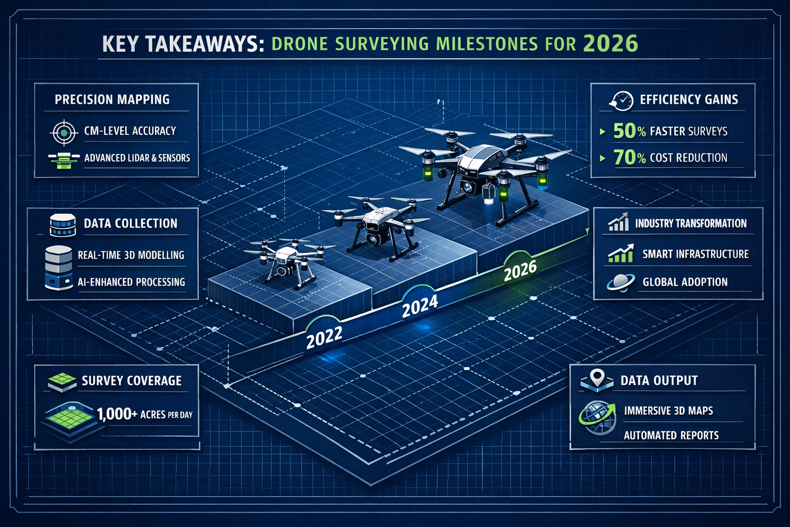
Key Takeaways
✅ Data quality parity: Modern drones collect the same quality of data as traditional ground-based surveys while operating significantly faster and at dramatically lower operational costs.[1]
✅ Massive time savings: Drone surveys reduce project completion time from days or weeks to just hours, enabling faster decision-making and accelerated project timelines across construction, infrastructure, and land management sectors.[1]
✅ Proven cost reductions: Real-world case studies demonstrate savings exceeding $80,000 annually when integrating drone technology with modern GIS platforms, with reduced equipment needs and smaller crew requirements.[2]
✅ Enhanced safety profile: UAV surveys eliminate risks associated with traditional methods by reducing the need for surveyors to navigate hazardous terrain, busy roadways, or structurally compromised buildings.[1]
✅ Expanding regulatory framework: New beyond visual line of sight (BVLOS) regulations in 2026 are enabling surveyors to cover larger areas and operate more efficiently than ever before.[3]
Understanding Drone Technology in Modern Land Surveying
What Makes Drone Surveying Different?
Drone surveying represents a fundamental shift in data collection methodology. Unlike traditional surveying that requires physical presence at each measurement point, UAV-based surveys capture thousands of data points per second from an aerial perspective. This bird's-eye view provides comprehensive coverage that would be impossible or prohibitively expensive to achieve with ground-based methods.
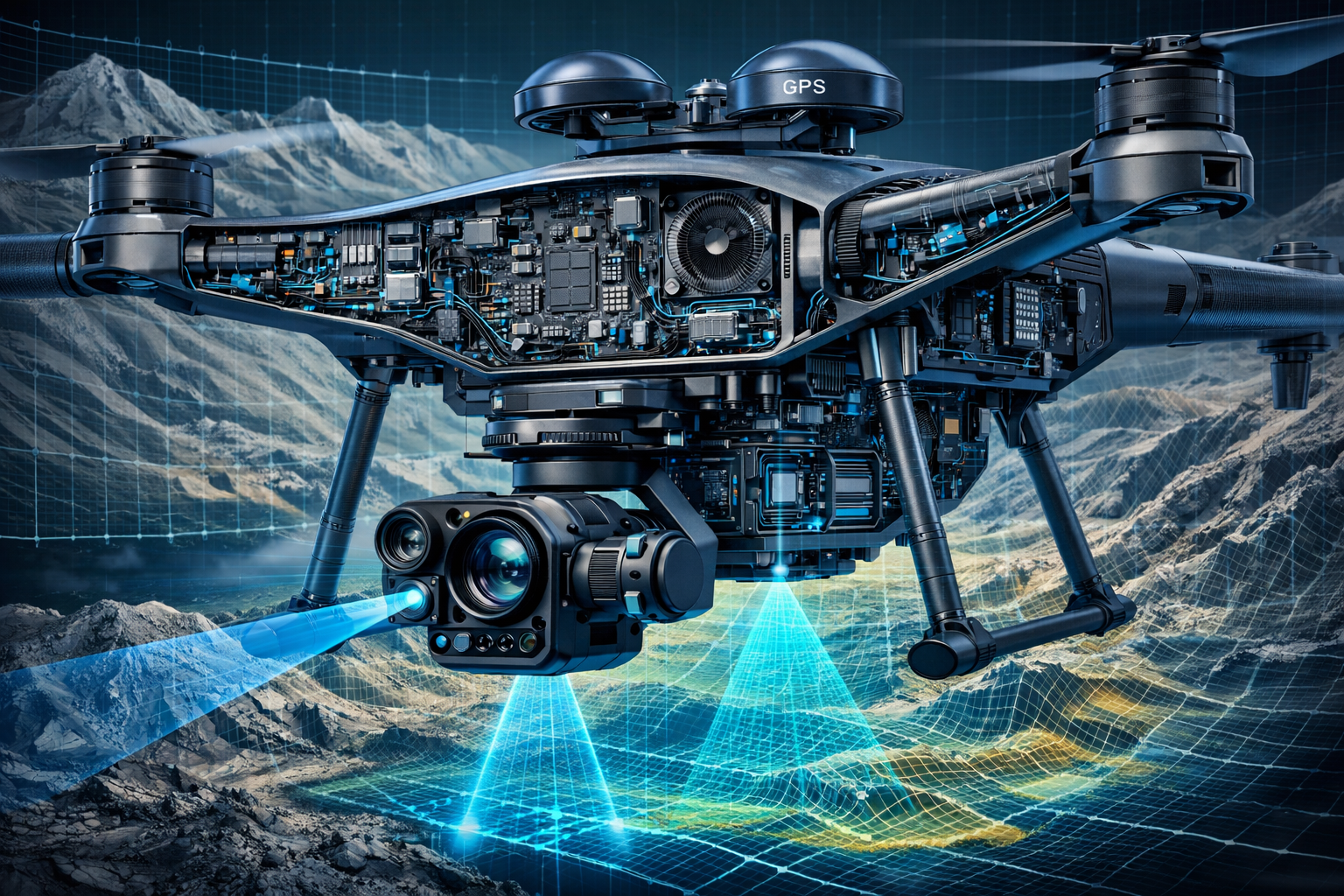
The technology combines several key components:
- 🚁 Advanced flight platforms: Commercial drones like the DJI Phantom 4 RTK and specialized surveying UAVs
- 📷 High-resolution cameras: Capturing overlapping images with centimeter-level accuracy
- 🔦 LiDAR sensors: Using laser pulses to create detailed 3D point clouds
- 📡 RTK/PPK GPS systems: Providing precise positioning data for georeferencing
- 💻 Processing software: Transforming raw data into actionable deliverables
The LiDAR Revolution in Aerial Surveying
LiDAR (Light Detection and Ranging) technology has revolutionized the surveying landscape in ways that seemed impossible just a decade ago. LiDAR-equipped drones emit rapid laser pulses—often hundreds of thousands per second—that bounce off surfaces and return to the sensor. By measuring the time delay, the system calculates precise distances and creates incredibly detailed three-dimensional models.[1]
The breakthrough capability of LiDAR is its ability to penetrate dense vegetation. Traditional photogrammetry struggles in forested areas where the ground surface is obscured by canopy cover. LiDAR pulses, however, can slip through gaps in foliage and reach the ground below, enabling accurate terrain mapping even in heavily wooded environments.
This capability has applications far beyond traditional surveying. Archaeologists have used LiDAR drones to discover previously unknown historical sites hidden beneath jungle canopy. Environmental scientists leverage the technology to produce precise carbon storage estimates for climate change mitigation research by accurately measuring forest biomass.[1]
For professional surveyors, LiDAR means complete terrain visibility regardless of ground conditions. Whether mapping a construction site with scattered equipment and materials or conducting topographic surveys in challenging landscapes, LiDAR provides comprehensive data that photogrammetry alone cannot match.
Key Drone Survey Deliverables
Modern drone surveying software transforms raw aerial data into multiple useful formats:[5]
| Deliverable Type | Description | Primary Applications |
|---|---|---|
| Orthomosaic Maps | Geometrically corrected aerial images with uniform scale | Site planning, progress monitoring, asset documentation |
| Digital Elevation Models (DEMs) | Raster representations of bare-earth terrain elevation | Topographic analysis, drainage planning, cut/fill calculations |
| Digital Surface Models (DSMs) | Elevation data including all surface features (buildings, vegetation) | 3D visualization, volumetric measurements, obstruction analysis |
| 3D Point Clouds | Dense collections of georeferenced XYZ coordinates | Detailed measurements, CAD integration, structural analysis |
| 3D Mesh Models | Textured 3D representations of surveyed areas | Stakeholder presentations, virtual site tours, design visualization |
| Contour Maps | Lines connecting points of equal elevation | Traditional surveying workflows, grading plans, hydrological studies |
These deliverables integrate seamlessly with modern design and planning software, enabling direct comparison between as-built conditions and design specifications. Cloud-based platforms facilitate real-time collaboration between field teams, project managers, and stakeholders.[2]
Revolutionizing Land Surveying: Cost and Efficiency Benefits in 2026
Quantifying the Time Savings
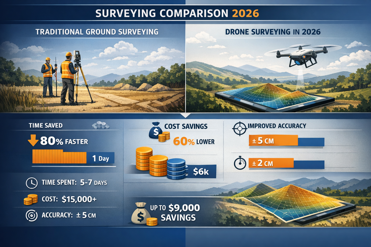
The time reduction achieved through drone surveying represents one of the most compelling advantages for project managers and surveying firms. Traditional ground-based topographic surveys of large sites can require days or even weeks of fieldwork, depending on site size, terrain complexity, and accessibility challenges.[1]
Drone surveys compress this timeline dramatically. A skilled drone operator can typically complete aerial data collection for a medium-sized construction site in 2-4 hours, including setup, flight operations, and ground control point placement. Processing time adds additional hours or overnight rendering, but total turnaround from deployment to deliverables often occurs within 24-48 hours.
This acceleration creates cascading benefits throughout project timelines:
- Faster decision-making: Project stakeholders receive actionable data within days instead of weeks
- Reduced project delays: Survey bottlenecks that once stalled construction schedules are eliminated
- More frequent monitoring: The speed and affordability enable weekly or even daily progress documentation
- Rapid response capability: Emergency surveys for disputes, damage assessment, or design changes can be executed immediately
Real-World Cost Savings: The Numbers Don't Lie
While time savings are impressive, the financial impact of drone integration often provides the most persuasive business case for adoption. Multiple cost factors contribute to overall savings:
Reduced Labor Requirements: Traditional surveys might require a crew of 3-5 professionals working multiple days. Drone surveys typically need just 1-2 operators for a few hours, dramatically reducing labor costs.[1]
Equipment Efficiency: Ground surveys require vehicles, total stations, GPS rovers, and various accessories. Drone operations consolidate equipment needs into a compact, portable package.
Minimized Site Disruption: Faster data collection means less interference with ongoing operations, reducing indirect costs associated with work stoppages or access restrictions.
A compelling case study comes from Dudek, an environmental engineering consulting firm that integrated drone technology with ArcGIS platforms. The firm documented savings exceeding $80,000 in a single year through reduced equipment costs, faster project completion, and improved operational efficiency.[2] These weren't theoretical projections—they were actual documented savings from real projects.
For surveying firms considering drone adoption, the return on investment timeline is remarkably short. A professional-grade RTK drone system might cost $15,000-25,000, but the labor and time savings on just a handful of projects often recover this investment within the first year of operation.
Workforce Optimization and Resource Allocation
Beyond direct cost savings, drone technology enables strategic workforce optimization. Surveying firms can accomplish the same project volume with smaller teams, or alternatively, expand their project capacity without proportionally increasing headcount.
This efficiency doesn't necessarily mean job losses. Instead, it enables surveyors to shift from physically demanding fieldwork to higher-value activities like data analysis, client consultation, and specialized problem-solving. Junior staff can be trained on drone operations more quickly than traditional surveying techniques, accelerating professional development.
The technology also addresses workforce challenges facing the surveying industry. As experienced surveyors retire, drone systems help newer professionals achieve productivity levels that might otherwise require years of field experience to develop.
Safety Improvements and Risk Reduction Through UAV Technology
Eliminating Hazardous Site Conditions
Traditional land surveying inherently involves significant safety risks. Surveyors must physically traverse the terrain they're measuring, which often includes:
- 🏗️ Active construction sites with heavy equipment and falling hazards
- 🚗 Busy roadways requiring traffic control and exposure to vehicles
- ⛰️ Steep slopes, unstable terrain, and challenging topography
- 🏚️ Structurally compromised buildings or hazardous structures
- 🌊 Areas near water bodies, cliffs, or other natural hazards
Each of these environments presents injury risks ranging from minor incidents to potentially fatal accidents. The surveying industry has historically experienced workplace injury rates higher than many other professional services sectors.
Drone surveying fundamentally changes this risk profile. By capturing data from the air, UAV operations eliminate the need for surveyors to enter many hazardous environments entirely.[1] A drone can safely survey a steep embankment, active roadway, or unstable structure while the operator remains in a safe location.
This safety improvement isn't just humanitarian—it has direct business implications. Workplace injuries create workers' compensation costs, project delays, regulatory scrutiny, and potential liability exposure. Reducing these risks protects both employees and business operations.
Regulatory Compliance and Documentation
Modern construction and infrastructure projects face increasingly stringent safety regulations. Drone technology supports compliance in several ways:
Pre-work hazard assessment: Aerial surveys can identify potential safety hazards before crews enter a site, enabling better safety planning.
Progress documentation: Regular drone surveys create timestamped visual records of site conditions, providing evidence of safety compliance and proper procedures.
Incident investigation: In the event of accidents or disputes, drone-captured data provides objective documentation of site conditions at specific points in time.
Remote inspections: Drone roof surveys enable building assessments without requiring surveyors to climb potentially unstable structures or work at dangerous heights.
The regulatory landscape in 2026 increasingly recognizes drone surveying as a best practice for safety-conscious organizations. Some insurance providers now offer premium reductions for firms that demonstrate comprehensive drone integration in their safety protocols.
Revolutionizing Land Surveying Applications: Real-World Case Studies
Infrastructure Megaprojects: The Norwegian Island Connection
One of the most impressive demonstrations of drone surveying capabilities comes from Skanska Norge AS, which is using Phantom 4 RTK drones integrated with ArcGIS Flight planning software to monitor construction of a massive infrastructure project connecting five Norwegian islands to the mainland.[2]
The project spans 22 miles and includes roadways, bridges, and subsea tunnels—a construction challenge of extraordinary complexity. Traditional surveying methods would struggle to provide comprehensive, frequent monitoring across such a large and geographically dispersed project area.
The drone-based approach enables the project team to create:
- 2D orthomosaic maps showing current conditions across the entire project corridor
- Digital elevation models tracking earthwork progress and grading accuracy
- 3D point clouds enabling precise measurements of constructed elements
- 3D mesh models providing visual context for stakeholder communication
Perhaps most impressively, this data is made accessible to island residents and stakeholders in near real-time through cloud-based platforms. This transparency builds public trust and enables rapid response to community concerns or design questions.
The project demonstrates how drone technology scales to meet the demands of the largest infrastructure initiatives while maintaining the precision required for engineering-grade deliverables.
Material Tracking and Stadium Construction
OCMI (a construction management firm) leveraged drone technology and Site Scan software for an innovative application: tracking the movement of concrete materials from San Diego's old stadium to the construction site of the new Snapdragon Stadium—now home to two professional soccer teams and San Diego State University's football team.[2]
This application highlights drone surveying's versatility beyond traditional topographic mapping. The project team used drones to:
- Quantify material stockpiles through volumetric analysis of drone-generated 3D models
- Track material movement between demolition and construction sites
- Validate contractor data by providing independent measurements of material quantities
- Document sustainability efforts by proving material reuse and diversion from landfills
The ability to accurately measure stockpile volumes represents significant value for construction projects. Traditional methods require manual measurements or expensive terrestrial laser scanning. Drones provide comparable accuracy at a fraction of the cost, enabling routine monitoring that would be economically impractical otherwise.
This case study also demonstrates the environmental benefits of drone surveying. By facilitating material reuse tracking, the technology supported sustainable construction practices and provided documentation for LEED certification and environmental reporting requirements.
Urban Planning and Asset Management
Municipal governments and urban planners are discovering that drone technology revolutionizes infrastructure asset management. Drones generate sharp orthomosaic maps and 3D representations that enable distinct identification of infrastructure features including:[1]
- 🚦 Traffic signage and signals
- 🛣️ Road markings and lane indicators
- 💧 Hydrants and water infrastructure
- 🌊 Drainage systems and stormwater management features
- 🚧 Curbs, sidewalks, and pedestrian infrastructure
This detailed documentation facilitates rapid creation of precise cadastral maps even in remote or challenging environments. For growing municipalities, drone surveys enable comprehensive infrastructure inventories that inform maintenance planning, capital budgets, and development decisions.
The technology proves particularly valuable for boundary surveys where precise property line documentation is essential. High-resolution orthomosaics provide visual evidence of fence lines, structures, and landscape features that inform boundary determinations.
Urban planners also use drone data for:
- Traffic flow analysis: Aerial imagery captures vehicle patterns and congestion points
- Green space monitoring: Vegetation health and park condition assessment
- Development impact studies: Before-and-after documentation of construction projects
- Emergency response planning: Detailed maps supporting fire, police, and medical services
Agricultural and Land Management Applications
Beyond construction and infrastructure, drone surveying has transformed agricultural monitoring and land management. Farmers and land managers use drone surveys to:[1]
- Assess crop health: Multispectral imaging identifies stressed vegetation before problems become visible to the naked eye
- Optimize irrigation: Thermal imaging reveals moisture distribution patterns across fields
- Monitor land conditions: Regular surveys track erosion, drainage issues, and soil conditions
- Document conservation efforts: Aerial data supports compliance with environmental programs and conservation easements
The agricultural sector has embraced drone technology particularly rapidly because the benefits directly impact profitability. Identifying crop stress early enables targeted intervention that protects yields. Optimizing irrigation reduces water costs and improves sustainability.
For land management professionals overseeing large properties, drones provide comprehensive oversight that would be impossible through ground-based inspection alone. A single flight can document hundreds of acres in detail, identifying maintenance needs, encroachments, or environmental concerns.
Advanced Software Integration and Processing Workflows
From Raw Data to Actionable Deliverables
The drone itself is only part of the surveying solution. Specialized processing software transforms the thousands of images and LiDAR data points captured during flights into the usable deliverables that clients require.[5]
Modern photogrammetry software uses sophisticated algorithms to:
- Align images: Identifying common features across overlapping photos
- Generate point clouds: Creating three-dimensional representations from two-dimensional images
- Build mesh models: Connecting point cloud data into continuous surfaces
- Apply textures: Draping original imagery onto 3D models for realistic visualization
- Georeference data: Positioning deliverables accurately in real-world coordinate systems
- Export formats: Creating files compatible with CAD, GIS, and design software
Processing requirements vary based on project size and deliverable complexity. Small sites might process in minutes on standard laptops, while large-scale projects with billions of data points may require powerful workstations or cloud processing services running overnight.
Cloud-Based Collaboration and Real-Time Comparison
The integration between ArcGIS and Autodesk technology represents a significant advancement in how survey data informs decision-making. Cloud-based platforms enable real-time comparison of as-built conditions versus as-designed specifications.[2]
This capability transforms quality control and project management workflows:
- Design verification: Immediately identify where construction deviates from plans
- Change order documentation: Visual evidence supporting or refuting contractor claims
- Progress tracking: Quantify completion percentages based on actual measurements
- Stakeholder communication: Share current conditions with remote team members instantly
The cloud-based approach also facilitates collaboration between different project disciplines. Architects, engineers, contractors, and chartered surveyors can all access the same current data, reducing miscommunication and ensuring everyone works from accurate information.
For surveying firms, cloud platforms enable efficient project management across multiple sites and teams. Field crews upload data from remote locations, processing occurs automatically, and deliverables become available to clients without physical media exchange or file transfer delays.
Integration with Traditional Surveying Workflows
Despite their advantages, drones don't completely replace traditional surveying methods. Instead, the most effective approach combines drone technology with conventional techniques where each method's strengths are maximized.
Ground control points (GCPs) remain essential for achieving survey-grade accuracy. These are precisely surveyed markers placed throughout the project area before drone flights. The drone imagery captures these markers, and processing software uses them to georeference the entire dataset to real-world coordinates.
Professional surveyors also use traditional equipment for:
- Boundary determinations: Legal property line establishment often requires conventional surveying methods
- Vertical control: Establishing precise elevation benchmarks for project reference
- Detail work: Measuring specific features that require direct access or extreme precision
- Verification: Checking drone-derived measurements against independent observations
The optimal workflow integrates both approaches. Drones provide comprehensive coverage and rapid data collection, while traditional methods establish control networks and verify critical measurements. This combination delivers both efficiency and the precision required for engineering and legal applications.
When conducting comprehensive property assessments, surveyors often combine drone surveys with traditional building surveys to provide clients with complete information about both site conditions and structural characteristics.
Regulatory Developments and Beyond Visual Line of Sight Operations
The Evolving Regulatory Landscape in 2026
Drone regulations have matured significantly, with aviation authorities worldwide recognizing the technology's value while maintaining appropriate safety oversight. In 2026, the regulatory framework continues evolving to enable expanded operational capabilities while protecting airspace safety.[3]
Key regulatory developments include:
Beyond Visual Line of Sight (BVLOS) Framework: New regulations are enabling surveyors to fly larger areas without maintaining constant visual contact with the aircraft. This dramatically expands the area that can be surveyed in a single operation, particularly valuable for linear infrastructure projects like pipelines, transmission lines, and roadways.[3]
Operational authorizations: Streamlined approval processes allow qualified operators to conduct complex operations including flights over people, night operations, and operations from moving vehicles.
Remote identification: New technical requirements enable authorities to identify and track drones remotely, improving accountability while facilitating expanded operational permissions.
Standardized training and certification: Professional drone surveying certifications are becoming standardized, helping clients identify qualified operators and supporting professional development.
Compliance Requirements for Professional Surveyors
Professional surveying firms must navigate multiple regulatory frameworks:
- ✈️ Aviation regulations: Drone pilot licensing, operational restrictions, and airspace authorizations
- 📋 Professional standards: Surveying board requirements and professional liability considerations
- 🔒 Data protection: Privacy regulations governing aerial imagery and data handling
- 🏢 Client-specific requirements: Industry standards for construction, infrastructure, or government projects
Maintaining compliance requires ongoing education as regulations continue evolving. Professional organizations and industry associations provide resources helping surveyors stay current with changing requirements.
Insurance considerations also play a role. Professional liability insurance for surveying firms increasingly includes specific provisions for drone operations, and some insurers require evidence of proper training and operational procedures.
Choosing the Right Drone Platform for Surveying Applications
Professional RTK Drones vs. Consumer Models
Not all drones are suitable for professional surveying work. The key differentiator is positioning accuracy. Consumer drones typically use standard GPS, which provides accuracy of several meters—insufficient for surveying applications requiring centimeter-level precision.
RTK (Real-Time Kinematic) and PPK (Post-Processed Kinematic) drones achieve survey-grade accuracy by using differential GPS correction. These systems compare the drone's GPS data against a base station with known coordinates, eliminating most GPS errors and achieving horizontal accuracy of 1-3 centimeters and vertical accuracy of 3-5 centimeters.
Popular professional surveying drones in 2026 include:
| Drone Model | Key Features | Typical Applications |
|---|---|---|
| DJI Phantom 4 RTK | Integrated RTK, 20MP camera, 30-minute flight time | Construction sites, small to medium topographic surveys |
| DJI Matrice 300 RTK | Modular payload system, 55-minute flight time, advanced safety features | Large-scale projects, LiDAR surveys, infrastructure inspection |
| senseFly eBee X | Fixed-wing design, 90-minute flight time, PPK capability | Large area mapping, agricultural surveys, corridor mapping |
| Quantum Trinity F90+ | Vertical takeoff fixed-wing, 2-hour flight time, BVLOS capable | Linear infrastructure, pipeline surveys, transmission line inspection |
LiDAR Integration and Sensor Selection
For projects requiring ground surface visibility beneath vegetation or extremely detailed 3D modeling, LiDAR-equipped drones provide capabilities that photogrammetry cannot match. LiDAR sensors vary significantly in specifications:
- Point density: Ranging from 50 to 500+ points per square meter
- Range: Maximum distance from sensor to ground, typically 100-300 meters
- Laser classification: Number of return signals processed (single, dual, or multiple)
- Scan pattern: How the laser sweeps across the terrain
- Weight: Critical factor for drone payload capacity and flight time
Higher-end LiDAR systems provide better penetration through vegetation and higher point density, but at significantly higher cost. Project requirements should drive sensor selection—not all applications require the most advanced (and expensive) systems.
Many surveying firms are finding that mid-range LiDAR systems costing $50,000-100,000 provide excellent value, offering sufficient performance for most projects while remaining economically viable for regular use.
Training and Professional Development for Drone Surveyors
Essential Skills and Knowledge Areas
Successful drone surveying requires a combination of traditional surveying knowledge and new technical competencies:
Core surveying principles: Understanding coordinate systems, datums, projections, and accuracy standards remains fundamental. Drone technology doesn't eliminate the need for surveying expertise—it changes how that expertise is applied.
Aviation knowledge: Safe drone operations require understanding airspace classifications, weather limitations, and flight planning principles.
Photogrammetry and remote sensing: Knowledge of how imagery becomes 3D models helps operators optimize flight parameters and troubleshoot processing issues.
Software proficiency: Competence with flight planning applications, processing software, and CAD/GIS platforms is essential for efficient workflows.
Data management: Large drone projects generate terabytes of data requiring organized storage, backup, and archival procedures.
Certification and Professional Credentials
Professional credentials demonstrate competence and support business development:
- Aviation authority drone pilot licenses: Required for legal commercial operations
- Professional surveying licenses: State or national surveying board certifications
- Manufacturer certifications: Training programs from DJI, senseFly, and other manufacturers
- Industry-specific credentials: Specialized certifications for infrastructure inspection, mapping, or other applications
Continuing education keeps professionals current with rapidly evolving technology. Industry conferences, webinars, and manufacturer training programs provide opportunities to learn about new capabilities and best practices.
When selecting a surveying firm, clients should verify appropriate credentials and ask about the firm's drone experience. Understanding what survey you need helps ensure you engage professionals with relevant expertise.
Future Trends and Emerging Technologies
Artificial Intelligence and Automated Processing
Artificial intelligence is beginning to transform how drone survey data is processed and analyzed. Machine learning algorithms can:
- Automatically classify features: Identifying roads, buildings, vegetation, and infrastructure elements without manual digitizing
- Detect changes: Comparing surveys from different dates to automatically identify modifications
- Quality control: Flagging potential errors or anomalies in data for human review
- Predictive analytics: Identifying patterns that suggest future maintenance needs or risks
These capabilities are moving from research laboratories into commercial software, promising to further reduce the time and expertise required to generate actionable intelligence from drone data.
Autonomous Operations and Swarm Technology
Fully autonomous drone operations are approaching commercial viability. Advanced systems can:
- Plan optimal flight paths based on project requirements
- Automatically avoid obstacles using onboard sensors
- Adapt to changing conditions like wind or lighting
- Return to base and swap batteries without human intervention
- Coordinate multiple drones surveying different areas simultaneously
Swarm technology—multiple drones operating cooperatively—could enable surveys of enormous areas in remarkably short timeframes. While regulatory and technical challenges remain, the trajectory is clear: drone surveying will become increasingly automated and efficient.
Integration with Digital Twins and BIM
Digital twins—virtual replicas of physical assets updated with real-time data—represent a growing application for drone surveying. Regular drone surveys provide the current-condition data that keeps digital twins accurate and useful for asset management, predictive maintenance, and operational optimization.
Integration with Building Information Modeling (BIM) workflows enables seamless comparison between design models and as-built conditions. This supports quality control during construction and creates accurate as-built documentation for facility management.
These applications extend drone surveying's value beyond initial data collection into ongoing asset lifecycle management, creating recurring revenue opportunities for surveying firms.
Implementing Drone Technology in Your Surveying Practice
Building the Business Case
For surveying firms considering drone adoption, a structured business case should address:
Investment requirements:
- Drone hardware and sensors: $15,000-100,000+ depending on capabilities
- Processing software licenses: $2,000-10,000 annually
- Training and certification: $2,000-5,000 per operator
- Insurance additions: Variable based on existing coverage
Revenue opportunities:
- Faster project completion enabling higher project volume
- New service offerings (progress monitoring, volumetric analysis, 3D modeling)
- Competitive advantage in proposal processes
- Premium pricing for advanced capabilities
Cost savings:
- Reduced field time and labor costs
- Lower equipment transportation and setup costs
- Decreased subcontractor expenses for specialized surveys
- Improved safety reducing injury-related costs
Most firms find that drone technology pays for itself within 12-24 months through a combination of increased revenue and reduced costs.
Starting Small and Scaling Up
A prudent implementation strategy begins with modest initial investment and scales based on demonstrated success:
Phase 1 – Pilot program: Acquire an entry-level RTK drone and processing software. Use it on selected projects to develop operator skills and refine workflows. Document time savings and client feedback.
Phase 2 – Integration: Incorporate drone surveys into standard service offerings. Develop marketing materials highlighting capabilities. Train additional staff members.
Phase 3 – Expansion: Based on demand and project types, consider advanced capabilities like LiDAR sensors, fixed-wing platforms, or specialized applications.
This graduated approach minimizes financial risk while building organizational competence and client demand.
Partnering and Outsourcing Options
Firms uncertain about full drone adoption can explore partnership or outsourcing models:
- Subcontracting: Engage specialized drone service providers for specific projects
- Equipment sharing: Partner with other firms to share drone investment and utilization
- Training partnerships: Collaborate with experienced operators during initial implementation
- Hybrid approach: Maintain in-house capability for routine work while outsourcing specialized applications
These models allow firms to offer drone services without full capital investment, testing market demand before committing to equipment purchases.
Addressing Common Challenges and Limitations
Weather and Environmental Constraints
Drone surveying faces weather limitations that don't affect traditional methods:
- Wind: Most surveying drones operate safely in winds up to 20-25 mph, but higher winds ground operations
- Precipitation: Rain damages electronics and degrades image quality
- Temperature: Extreme cold reduces battery performance; extreme heat causes overheating
- Lighting: Optimal imagery requires adequate sunlight; shadows complicate processing
Project scheduling must account for these constraints. Time-sensitive projects may require backup plans or hybrid approaches combining drone and traditional methods.
Accuracy Considerations and Limitations
While drone surveys achieve impressive accuracy, understanding limitations is essential:
Vertical surfaces: Drones excel at capturing overhead perspectives but struggle with vertical features like building facades or cliff faces. Specialized flight patterns or terrestrial methods may be necessary.
Dense vegetation: Even LiDAR has limits in extremely dense canopy. Ground verification may be required in heavily forested areas.
Reflective or transparent surfaces: Water, glass, and highly reflective materials can confuse photogrammetry algorithms, requiring special processing techniques.
Accuracy verification: Professional practice requires independent verification of drone-derived measurements, typically through ground control points and check shots with traditional equipment.
Understanding these limitations ensures appropriate application and prevents over-reliance on technology where traditional methods remain superior.
Data Management and Storage Requirements
Drone surveys generate enormous data volumes. A single project might produce:
- 500-2,000 high-resolution images (20-80 GB)
- Processed point clouds (10-100 GB)
- 3D models and orthomosaics (5-50 GB)
- Derivative products and exports (variable)
Total storage requirements can easily reach 100-200 GB per project. Multiply this across dozens or hundreds of annual projects, and data management becomes a significant consideration.
Effective data management strategies include:
- Structured file organization: Consistent naming conventions and folder structures
- Redundant backups: Multiple copies on separate systems or cloud storage
- Archival policies: Determining retention periods and long-term storage solutions
- Client deliverable management: Efficient transfer of large files to clients
- Hardware planning: Adequate server capacity and network bandwidth
Failing to plan for data management can create operational bottlenecks that negate the efficiency gains from drone technology.
Conclusion: Embracing the Future of Land Surveying
Revolutionizing Land Surveying: The 2026 Guide to Drone and UAV Applications demonstrates that drone technology has moved far beyond experimental status. It now represents a proven, essential capability for modern surveying practices. The combination of affordable hardware, sophisticated software, and maturing regulations has created an environment where drone surveying delivers measurable advantages in cost, efficiency, safety, and capability.
The case studies presented—from Norwegian infrastructure megaprojects to stadium construction material tracking—prove that drone technology scales from small local projects to massive undertakings. The documented savings of over $80,000 annually for firms like Dudek demonstrate that financial benefits are real and substantial, not theoretical projections.[2]
For surveying professionals, the question is no longer whether to adopt drone technology, but how quickly to implement it and which applications to prioritize. The competitive landscape increasingly expects drone capabilities as standard offerings, making adoption essential for maintaining market position.
Actionable Next Steps
For surveying firms ready to embrace drone technology:
-
Assess your project portfolio: Identify which current projects would benefit most from drone capabilities. Focus on applications where time savings, safety improvements, or cost reductions are most significant.
-
Develop technical competency: Invest in training for key staff members. Obtain necessary aviation licenses and professional certifications. Consider starting with manufacturer-sponsored training programs.
-
Start with appropriate technology: Match initial equipment purchases to your specific applications. An RTK drone and photogrammetry software provides excellent starting capability for most firms.
-
Create demonstration projects: Document time, cost, and quality metrics on early projects. Build a portfolio of successful applications to support marketing and business development.
-
Establish workflows and standards: Develop standardized procedures for flight planning, data processing, quality control, and deliverable creation. Consistency improves efficiency and quality.
-
Engage with clients: Educate existing clients about new capabilities. Demonstrate how drone surveys can address their challenges more effectively than traditional methods.
-
Monitor regulatory developments: Stay informed about evolving aviation regulations and operational authorizations. Take advantage of new capabilities like BVLOS operations as they become available.[3]
-
Plan for scaling: As demand grows, develop strategies for expanding capabilities, training additional operators, and potentially adding specialized sensors or platforms.
The surveying industry stands at a transformative moment. Firms that effectively integrate drone technology position themselves for growth and competitive advantage. Those that delay risk falling behind competitors who deliver faster, more cost-effective services with enhanced safety profiles.
The revolution in land surveying is not coming—it's already here. The question is whether your practice will lead the transformation or struggle to catch up. The tools, technology, and proven methodologies exist today to fundamentally improve how surveying services are delivered. The opportunity is clear; the time to act is now.
Whether you're conducting boundary surveys, building surveys, or specialized assessments, drone technology offers capabilities that enhance traditional surveying methods and open new service possibilities. The future of land surveying combines the precision and expertise of professional surveyors with the efficiency and capability of advanced drone technology—creating outcomes that neither could achieve alone.
References
[1] Drone Surveying – https://uavcoach.com/drone-surveying/
[2] With Gis Technology Drone Industry Alights In Reality – https://www.esri.com/about/newsroom/arcnews/with-gis-technology-drone-industry-alights-in-reality
[3] Watch – https://www.youtube.com/watch?v=CSTodaZb4Vc
[4] Webinar The State Of Drone Surveying A Strategic Briefing For 2026 – https://www.aerotas.com/blog/webinar-the-state-of-drone-surveying-a-strategic-briefing-for-2026
[5] Revolutionizing Land Surveying The Rise Of Drone Technology And Uav Applications In 2026 – https://nottinghillsurveyors.com/blog/revolutionizing-land-surveying-the-rise-of-drone-technology-and-uav-applications-in-2026