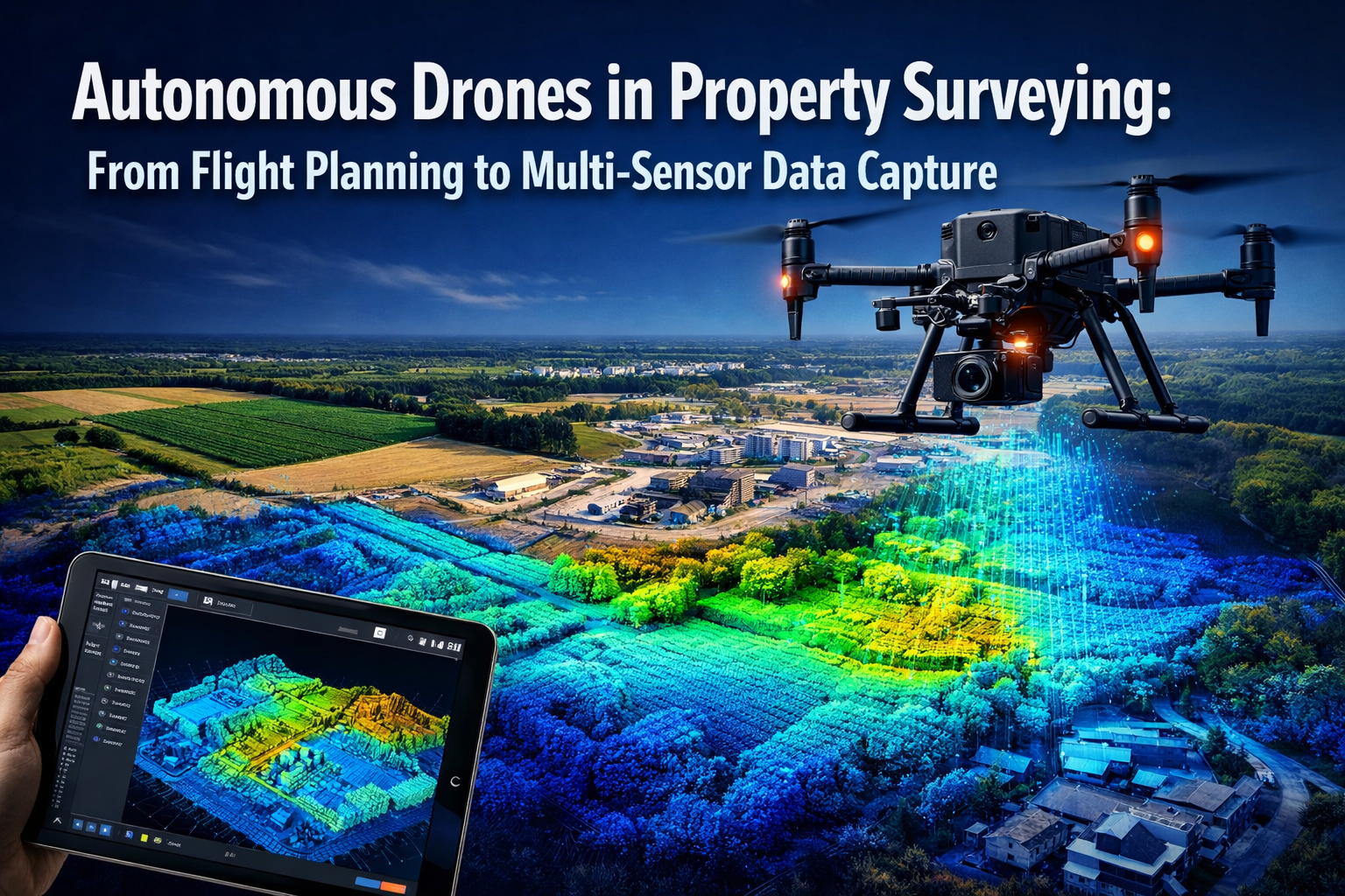
The property surveying industry is experiencing a transformation unlike anything seen in the past century. Where surveyors once spent weeks traversing large parcels with measuring equipment, autonomous drones now complete the same tasks in hours—with unprecedented accuracy and detail. In 2026, the integration of self-adjusting unmanned aerial vehicles (UAVs) equipped with multi-sensor arrays has fundamentally changed how agricultural land, development properties, and commercial sites are assessed, mapped, and documented.
Autonomous Drones in Property Surveying: From Flight Planning to Multi-Sensor Data Capture represents more than just technological advancement; it signals a complete reimagining of surveying workflows, cost structures, and data quality standards. This comprehensive guide explores how modern drone technology has evolved from simple aerial photography to sophisticated autonomous systems capable of intelligent flight planning, real-time sensor adjustment, and simultaneous multi-spectrum data collection.
Key Takeaways
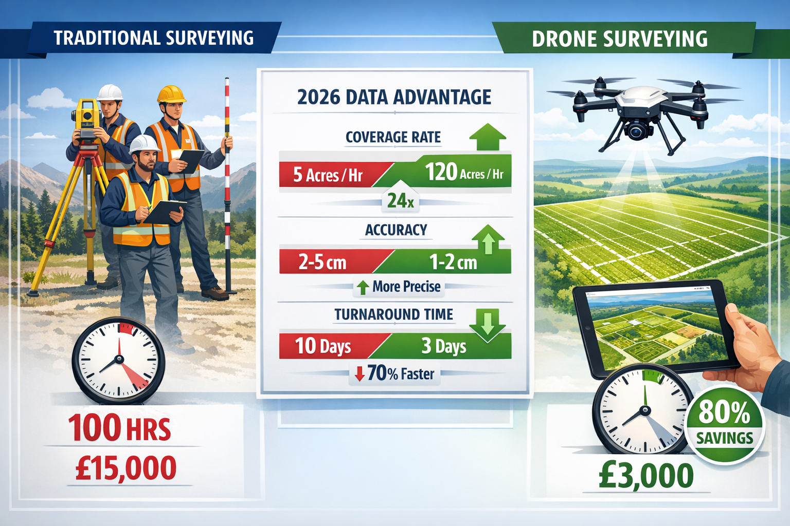
✅ Dramatic efficiency gains: Autonomous drones survey 120 acres per hour compared to just 5 acres for traditional ground teams—a 24x improvement in coverage rates[3]
✅ Superior accuracy: Modern UAV systems deliver 1-2 cm precision, outperforming traditional methods that typically achieve 2-5 cm accuracy[3]
✅ Significant cost reduction: Drone surveying reduces project costs by 30% and documentation time by 40%, with large property surveys dropping from 100 hours to as little as 2 hours[3][5]
✅ Multi-sensor integration: Contemporary platforms combine LiDAR, photogrammetry, thermal imaging, and multispectral sensors in synchronized operation, capturing comprehensive data in a single flight[1]
✅ Rapid project delivery: Survey turnaround times for homebuilders have decreased from 10 days to 3 days or less through automated workflows and Drone-as-a-Service (DaaS) models[2]
Understanding the Evolution of Autonomous Flight Planning
The journey from manual drone operation to fully autonomous surveying systems represents one of the most significant technological leaps in property assessment. Traditional drone surveying required skilled pilots to manually navigate flight paths, adjust camera angles, and ensure adequate overlap for photogrammetry processing. This human-dependent approach limited scalability and introduced variability in data quality.
The Shift to Intelligent Automation
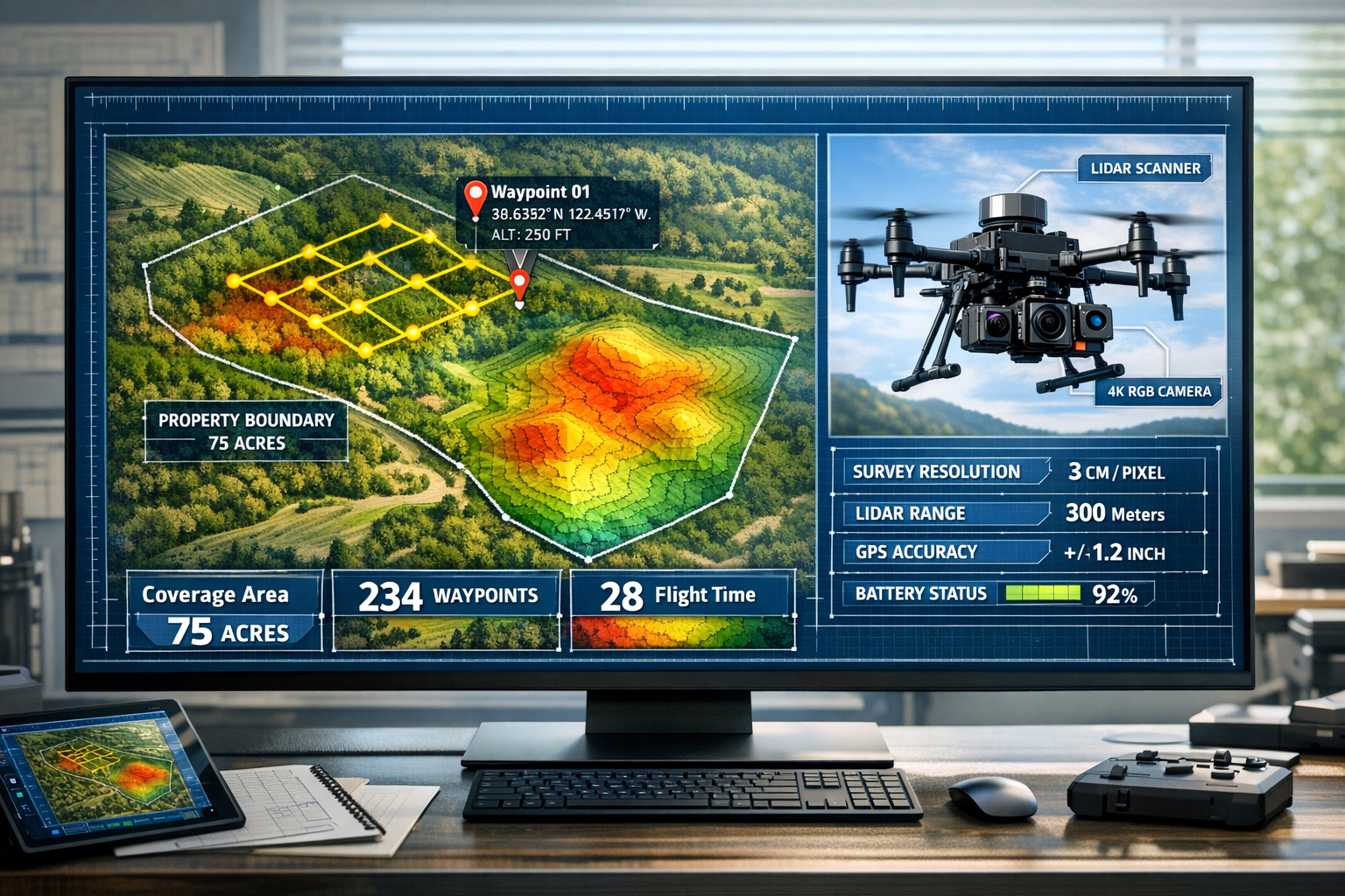
Modern autonomous flight planning systems have eliminated these constraints through predictive algorithms and machine learning integration. Today's platforms analyze property boundaries, terrain characteristics, and desired output specifications to automatically generate optimal flight paths without human intervention during operation[1].
These systems consider multiple variables simultaneously:
- Terrain elevation changes and obstacle detection
- Sensor-specific requirements for different data types
- Weather conditions and lighting optimization
- Battery management and automatic return-to-home protocols
- Overlap percentages for accurate 3D reconstruction
The result is a surveying process that adapts in real-time. If a drone encounters unexpected terrain features or lighting conditions, modern systems automatically adjust altitude, angle, and sensor selection to maintain data quality standards[1].
Predictive Modeling and Pre-Flight Optimization
Before a single propeller spins, advanced software now models the entire survey mission. Engineers and surveyors input property boundaries and desired deliverables—whether topographic maps, volumetric calculations, or thermal analysis—and the system calculates:
- Optimal flight altitude for target ground sample distance (GSD)
- Camera angle adjustments for vertical structures
- Flight speed balanced against sensor exposure requirements
- Number of battery swaps needed for large properties
- Estimated completion time and data volume
This predictive approach has proven particularly valuable for large-scale agricultural properties and development sites where survey accuracy directly impacts project feasibility and regulatory compliance. Professional drone roof surveys demonstrate how automated flight planning ensures comprehensive coverage even for complex structures.
Integration with Geographic Information Systems (GIS)
The power of autonomous flight planning multiplies when integrated with existing GIS data. Modern systems import cadastral boundaries, topographic information, and existing survey data to create context-aware flight plans. This integration ensures:
- Precise boundary coverage without trespassing on adjacent properties
- Targeted data collection for specific features of interest
- Historical comparison capabilities for change detection
- Regulatory compliance documentation for planning applications
For surveyors working on structural surveys or comprehensive property assessments, this GIS integration provides invaluable context that enhances both efficiency and accuracy.
Multi-Sensor Data Capture: Beyond Simple Photography
The transformation of drones from simple aerial cameras to sophisticated multi-sensor platforms represents perhaps the most significant advancement in property surveying technology. While early UAV applications focused primarily on RGB photography, 2026 systems integrate multiple synchronized sensors that capture vastly different types of data simultaneously.
The Multi-Sensor Arsenal
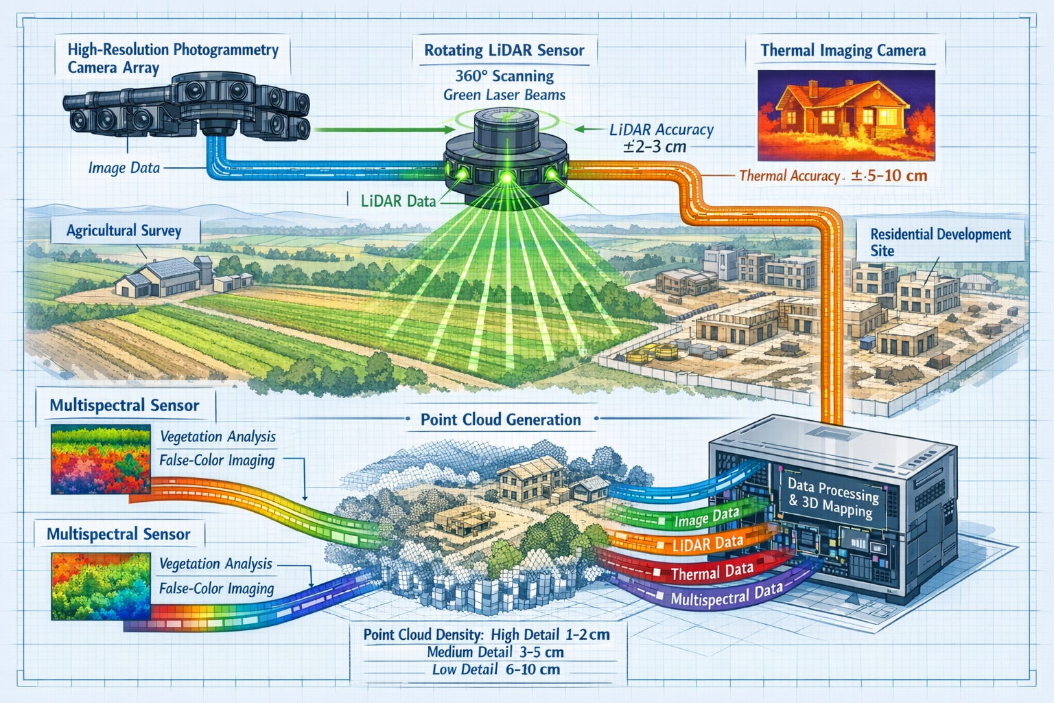
Modern autonomous drones deploy an impressive array of sensing technologies, each serving distinct analytical purposes:
LiDAR (Light Detection and Ranging) systems emit millions of laser pulses per second, creating precise three-dimensional point clouds that penetrate vegetation and capture bare-earth terrain models. This technology proves invaluable for:
- Topographic mapping beneath tree canopy
- Volumetric calculations for earthwork projects
- Infrastructure inspection and clearance verification
- Flood modeling and drainage analysis
High-Resolution Photogrammetry Cameras capture overlapping images processed into orthomosaic maps and 3D models. These RGB sensors provide:
- True-color visual documentation
- Texture mapping for 3D models
- Feature identification and classification
- Change detection through temporal comparison
Thermal Imaging Sensors detect infrared radiation, revealing temperature variations invisible to standard cameras. Applications include:
- Building envelope analysis and insulation defects
- Moisture intrusion detection
- Solar panel efficiency assessment
- Vegetation health monitoring
Multispectral and Hyperspectral Sensors capture data across multiple wavelength bands beyond visible light, enabling:
- Crop health assessment through NDVI (Normalized Difference Vegetation Index)
- Soil composition analysis
- Water quality monitoring
- Vegetation species classification
Synchronized Operation and Data Fusion
The true power of multi-sensor systems emerges through synchronized operation. Modern platforms like the DJI Matrice 350 RTK can carry multiple sensors simultaneously, with onboard computers time-stamping and geo-referencing all data streams to create unified datasets[3].
This synchronization enables sophisticated analytical techniques:
| Analysis Type | Sensors Combined | Application |
|---|---|---|
| Precision Agriculture | Multispectral + LiDAR | Crop health mapping with terrain-corrected indices |
| Building Assessment | Thermal + RGB + LiDAR | Comprehensive structural analysis with thermal defects |
| Development Planning | LiDAR + Photogrammetry | Accurate volumetric calculations with visual context |
| Environmental Monitoring | Multispectral + Thermal | Vegetation stress detection and water resource mapping |
The ability to capture complementary data types in a single flight eliminates the need for multiple site visits, dramatically reducing project timelines and costs. For comprehensive property evaluations, this multi-sensor approach provides the detailed information necessary for building surveys and specialized assessments.
Real-Time Data Processing and Quality Control
Advanced autonomous systems now incorporate edge computing capabilities that process sensor data during flight. This real-time analysis enables:
- Immediate quality verification to detect coverage gaps
- Automatic mission adjustments to recapture problematic areas
- Preliminary data visualization available before landing
- Storage optimization through selective data retention
Surveyors can review initial results on-site and make informed decisions about additional data collection needs before demobilizing equipment—a capability that would have seemed impossible just a few years ago.
Autonomous Drones in Property Surveying: Cost-Benefit Analysis for 2026
Understanding the financial implications of adopting autonomous drone technology requires examining both direct costs and broader operational impacts. The 2026 landscape reveals compelling economics that have driven rapid industry adoption across agricultural, development, and commercial property sectors.
Direct Cost Comparisons
The financial advantages of drone surveying become immediately apparent when comparing traditional ground-based methods to autonomous UAV systems:
Traditional Ground Survey Costs (12-acre property):
- Labor: 3-person crew × 33 hours = 100 person-hours
- Equipment rental and transportation
- Processing and CAD drafting time
- Total time: 10-15 days
- Typical cost: £12,000-£18,000
Autonomous Drone Survey Costs (same property):
- Flight time: 1-2 hours (including setup)
- Processing time: 4-6 hours (largely automated)
- Single operator required
- Total time: 1-3 days
- Typical cost: £2,500-£5,000
This represents a reduction of 98% in field time and 60-75% in total project costs for large properties[5]. The global drone services market, projected to exceed $30 billion by 2026, reflects the widespread recognition of these economic benefits[4].
Accuracy and Data Quality Benefits
Beyond speed and cost, autonomous drones deliver superior data quality that provides additional value:
- Centimeter-level accuracy (1-2 cm) compared to 2-5 cm for traditional methods[3]
- Complete coverage without accessibility constraints
- Repeatable measurements for temporal analysis
- Comprehensive documentation including visual, thermal, and elevation data
This enhanced accuracy reduces costly errors in development projects, boundary disputes, and construction planning. For properties requiring valuation services, precise measurements directly impact assessment accuracy and defensibility.
Operational Efficiency Gains
The operational benefits extend beyond individual project savings:
Reduced Turnaround Times:
- Homebuilder surveys: 10 days reduced to 3 days or less[2]
- Documentation time: 40% reduction in processing workflows[3]
- Emergency assessments: Same-day delivery capability
Enhanced Safety:
- Elimination of hazardous site access requirements
- No personnel exposure to unstable structures
- Reduced traffic management needs for roadside surveys
Scalability:
- Single operator can manage multiple projects daily
- Consistent quality regardless of property size
- Rapid deployment for time-sensitive projects
The Drone-as-a-Service (DaaS) Model
For organizations without capital budgets for drone acquisition, the Drone-as-a-Service model has emerged as the preferred approach in 2026. This delivery mechanism provides:
✈️ No capital investment in equipment or training
✈️ Access to latest technology without depreciation concerns
✈️ Specialized expertise for complex survey requirements
✈️ Scalable capacity matching project demand
The DaaS model is rapidly becoming the standard for industries requiring accurate, real-time data, with specialized providers offering comprehensive services including topography, plot plans, boundary validation, and zoning compliance[2][4].
Return on Investment (ROI) Analysis
Organizations investing in autonomous drone capabilities typically achieve ROI within 6-12 months through:
Revenue Enhancement:
- Ability to accept more projects with existing staff
- Premium pricing for rapid delivery services
- New service offerings (thermal analysis, multispectral mapping)
- Competitive advantage in bid situations
Cost Reduction:
- Lower labor costs per project
- Reduced equipment rental expenses
- Decreased insurance costs (fewer personnel in hazardous locations)
- Minimized vehicle and fuel expenses
Risk Mitigation:
- Reduced liability exposure from site accidents
- Improved accuracy reducing error-related costs
- Better documentation for dispute resolution
- Enhanced client satisfaction and retention
For professional surveying firms offering services like dilapidation surveys or subsidence assessments, drone capabilities have transitioned from competitive advantage to operational necessity.
Agricultural Property Applications: Precision at Scale
The agricultural sector has emerged as one of the most significant beneficiaries of autonomous drone surveying technology. Large-scale farming operations, vineyard management, and ranch properties present unique challenges that align perfectly with UAV capabilities.
Crop Health Monitoring and Yield Optimization
Modern agricultural drones equipped with multispectral sensors capture vegetation indices that reveal crop health patterns invisible to the human eye. The NDVI (Normalized Difference Vegetation Index) and similar metrics enable:
- Early disease detection before visual symptoms appear
- Irrigation efficiency analysis identifying over- and under-watered zones
- Nutrient deficiency mapping for targeted fertilizer application
- Yield prediction modeling based on vegetation vigor
A single autonomous flight over a 500-acre farm captures comprehensive multispectral data in approximately 4 hours—a task that would require weeks of ground-based sampling. The resulting maps guide precision agriculture practices that optimize input costs while maximizing yields.
Topographic Mapping for Drainage and Irrigation
LiDAR-equipped drones create detailed elevation models essential for:
- Drainage system design preventing waterlogging and erosion
- Irrigation planning ensuring efficient water distribution
- Terrace and contour farming layout optimization
- Flood risk assessment for low-lying agricultural areas
The 1-2 cm vertical accuracy achieved by modern systems[3] enables engineers to design drainage solutions that function as intended, eliminating costly trial-and-error approaches.
Boundary Verification and Acreage Calculation
Property boundary disputes and acreage verification represent common challenges for agricultural landowners. Autonomous drones provide:
- Precise boundary documentation using GPS-corrected orthomosaics
- Accurate acreage calculations for lease agreements and valuations
- Encroachment detection identifying unauthorized use
- Historical comparison tracking boundary changes over time
These capabilities prove particularly valuable for boundary surveys and property transactions requiring verified measurements.
Development Property Surveying: From Planning to Completion
Residential and commercial development projects benefit enormously from autonomous drone surveying throughout the entire project lifecycle—from initial site assessment through final as-built documentation.
Pre-Development Site Analysis
Before breaking ground, developers require comprehensive site understanding:
Topographic Surveys:
- Detailed elevation models for grading plans
- Cut-and-fill volume calculations
- Drainage pattern analysis
- Access route planning
Environmental Assessment:
- Vegetation mapping and tree surveys
- Wetland delineation
- Habitat identification
- Solar exposure analysis
Infrastructure Planning:
- Utility corridor identification
- Road alignment optimization
- Stormwater management design
- Site access evaluation
Autonomous drones complete these assessments in days rather than weeks, accelerating project timelines and enabling faster decision-making during critical planning phases.
Construction Progress Monitoring
During active construction, regular drone surveys provide invaluable project management capabilities:
📊 Progress Documentation:
- Weekly or daily site overviews
- Earthwork volume verification
- Material stockpile measurements
- Timeline compliance tracking
📊 Quality Control:
- Grade verification against design specifications
- Drainage system installation verification
- Foundation placement accuracy
- Structural alignment confirmation
📊 Stakeholder Communication:
- Visual progress reports for investors
- Marketing materials for pre-sales
- Regulatory compliance documentation
- Dispute resolution evidence
The 40% reduction in documentation time[3] achieved through automated drone workflows translates directly to faster project delivery and reduced administrative overhead.
As-Built Documentation and Handover
Upon project completion, comprehensive as-built surveys provide:
- Accurate site plans reflecting actual construction
- Digital twin creation for facility management
- Compliance verification for regulatory approval
- Warranty documentation establishing baseline conditions
This documentation proves essential for chartered surveyor services and ongoing property management.
Advanced Technologies Shaping the Future
While 2026 autonomous drone capabilities already seem remarkable, emerging technologies promise even greater advancements in property surveying applications.
Autonomous Drone Swarms
The development of coordinated drone swarms represents a significant evolution beyond single-platform operations[6]. Multiple drones operating in synchronized formation can:
- Survey massive properties in parallel
- Capture simultaneous multi-angle perspectives
- Provide redundant data collection for quality assurance
- Adapt dynamically to changing conditions
Early implementations show swarm technology reducing survey time for large development sites by an additional 60% compared to single-drone operations.
Artificial Intelligence and Machine Learning Integration
AI-powered analysis transforms raw sensor data into actionable intelligence:
Automated Feature Extraction:
- Building footprint delineation
- Vegetation classification
- Infrastructure identification
- Change detection and anomaly flagging
Predictive Analytics:
- Structural deterioration forecasting
- Crop yield prediction
- Erosion risk modeling
- Maintenance scheduling optimization
Quality Enhancement:
- Automatic image correction and enhancement
- Noise reduction in LiDAR data
- Gap filling and data interpolation
- Accuracy validation and error flagging
Digital Twin and BIM Integration
The integration of drone-captured data with Building Information Modeling (BIM) and digital twin platforms creates living, updateable property models. This integration enables:
- Real-time site monitoring with automatic model updates
- 4D construction sequencing linking time to spatial data
- Clash detection between design and as-built conditions
- Lifecycle asset management from construction through demolition
These digital representations reduce costly project mistakes and provide unprecedented visibility into property conditions and changes over time[3].
Extended Range and Endurance
Battery technology improvements and hybrid power systems are extending operational capabilities:
- 55+ minute flight times with heavy sensor payloads[3]
- Beyond visual line of sight (BVLOS) operations for large properties
- Automatic battery swapping for continuous multi-hour missions
- Solar-assisted charging for remote location operations
These advancements enable single-mission surveys of properties that previously required multiple days of fieldwork.
Regulatory Considerations and Best Practices
The rapid adoption of autonomous drones in property surveying operates within an evolving regulatory framework designed to ensure safety, privacy, and data quality.
Aviation Authority Requirements
In the UK and most jurisdictions, commercial drone operations require:
- Operator certification demonstrating competency
- Aircraft registration and identification
- Insurance coverage for liability protection
- Operational authorizations for specific flight types
Autonomous operations often require additional approvals demonstrating:
- Reliable fail-safe mechanisms
- Obstacle detection and avoidance capabilities
- Communication redundancy
- Emergency response protocols
Data Privacy and Property Rights
Surveying operations must respect privacy and property rights:
Privacy Considerations:
- Notification of adjacent property owners
- Limitations on residential area overflights
- Data retention and sharing policies
- Compliance with GDPR and data protection regulations
Property Access:
- Written permission for aerial surveys
- Respect for airspace rights
- Coordination with local authorities
- Documentation of authorization
Professional Standards and Accreditation
Maintaining professional standards ensures data quality and defensibility:
- RICS (Royal Institution of Chartered Surveyors) guidelines for drone surveying
- Calibration and validation of sensor systems
- Quality assurance protocols for deliverables
- Continuing professional development in emerging technologies
Surveyors offering comprehensive services including specific defect reports must ensure drone-derived data meets the same quality standards as traditional survey methods.
Implementation Roadmap for Surveying Firms
Organizations considering autonomous drone adoption should follow a structured implementation approach to maximize success and ROI.
Phase 1: Assessment and Planning (Months 1-2)
Needs Analysis:
- Identify target applications and service offerings
- Assess current project types and volumes
- Evaluate competitive landscape
- Define success metrics and ROI targets
Technology Selection:
- Research platform capabilities and limitations
- Compare DaaS versus ownership models
- Evaluate software and processing requirements
- Consider scalability and upgrade paths
Phase 2: Acquisition and Training (Months 2-4)
Equipment Procurement:
- Select appropriate drone platform(s)
- Acquire necessary sensors and accessories
- Implement data processing infrastructure
- Establish maintenance and support arrangements
Team Development:
- Obtain required certifications and licenses
- Complete manufacturer training programs
- Develop internal operating procedures
- Establish quality control protocols
Phase 3: Pilot Projects (Months 4-6)
Controlled Implementation:
- Select low-risk initial projects
- Document workflows and timelines
- Compare results against traditional methods
- Refine procedures based on lessons learned
Quality Validation:
- Verify accuracy against ground control
- Test deliverable formats and client acceptance
- Identify process bottlenecks
- Optimize data processing workflows
Phase 4: Full Deployment (Months 6-12)
Service Integration:
- Incorporate drone capabilities into standard offerings
- Update marketing materials and proposals
- Train client-facing staff on capabilities
- Establish pricing structures
Continuous Improvement:
- Monitor performance metrics and ROI
- Gather client feedback
- Stay current with technology developments
- Expand capabilities and applications
Conclusion: Embracing the Autonomous Revolution
The integration of Autonomous Drones in Property Surveying: From Flight Planning to Multi-Sensor Data Capture represents far more than incremental improvement—it constitutes a fundamental transformation of how properties are assessed, documented, and understood. The 2026 landscape reveals an industry where autonomous systems deliver 24x faster coverage rates, superior accuracy, and dramatic cost reductions compared to traditional methods[3][5].
The compelling economics—with large property surveys reduced from 100 hours to 2 hours and costs dropping by 60-75%—have moved drone technology from novelty to necessity. Multi-sensor integration capturing LiDAR, photogrammetry, thermal, and multispectral data in synchronized operation provides comprehensive property intelligence previously unattainable through any single methodology[1].
For agricultural properties, development sites, and commercial facilities, autonomous drone surveying delivers:
✅ Unmatched efficiency through intelligent flight planning and real-time adaptation
✅ Superior data quality with centimeter-level accuracy and complete coverage
✅ Comprehensive analysis combining multiple sensor types and data streams
✅ Rapid delivery with turnaround times reduced from 10 days to 3 days or less
✅ Cost effectiveness through 30% project savings and 40% documentation time reduction
Next Steps for Property Professionals
Whether you're a surveying firm, property developer, agricultural operator, or facility manager, the path forward involves strategic engagement with autonomous drone technology:
For Surveying Professionals:
- Evaluate your current service mix and identify high-value drone applications
- Consider DaaS partnerships for immediate capability without capital investment
- Invest in training and certification to build internal expertise
- Implement pilot projects to validate workflows and ROI
For Property Developers:
- Incorporate drone surveys into project planning and budgeting
- Require regular progress monitoring for active construction sites
- Leverage digital twin integration for facility management
- Utilize comprehensive documentation for regulatory compliance
For Agricultural Operators:
- Explore multispectral monitoring for crop health optimization
- Implement precision agriculture practices guided by drone data
- Conduct regular topographic surveys for drainage and irrigation planning
- Maintain accurate boundary documentation for lease and sale transactions
The autonomous drone revolution in property surveying is not a future possibility—it's the present reality of 2026. Organizations that embrace these capabilities gain competitive advantages through faster delivery, superior accuracy, and enhanced service offerings. Those that delay adoption risk obsolescence in an industry where client expectations increasingly demand the speed, precision, and comprehensive analysis that only autonomous multi-sensor drone systems can provide.
The question is no longer whether to adopt autonomous drone technology, but how quickly you can integrate these transformative capabilities into your property surveying and management practices. The tools, expertise, and proven methodologies exist today to revolutionize your approach to property assessment—the only remaining requirement is the decision to begin.
References
[1] Future Land Surveying 2026 – https://haller-blanchard.com/future-land-surveying-2026/
[2] Zenatech S Drone As A Service Expands Builder Services Capability Delivering Drone Driven Speed And Precision To Surveying For Homebuilders 1035808701 – https://markets.businessinsider.com/news/currencies/zenatech-s-drone-as-a-service-expands-builder-services-capability-delivering-drone-driven-speed-and-precision-to-surveying-for-homebuilders-1035808701
[3] Uav Construction – https://www.extremeaerialproductions.com/post/uav-construction
[4] Drone Survey Operations Drive Scalable Growth In Drones As A Service Daas – https://www.globenewswire.com/news-release/2026/02/05/3233129/0/en/Drone-Survey-Operations-Drive-Scalable-Growth-in-Drones-as-a-Service-DaaS.html
[5] Drones In Construction – https://uavcoach.com/drones-in-construction/
[6] Revolutionizing Land Surveying The Rise Of Drone Technology And Uav Applications In 2026 – https://nottinghillsurveyors.com/blog/revolutionizing-land-surveying-the-rise-of-drone-technology-and-uav-applications-in-2026