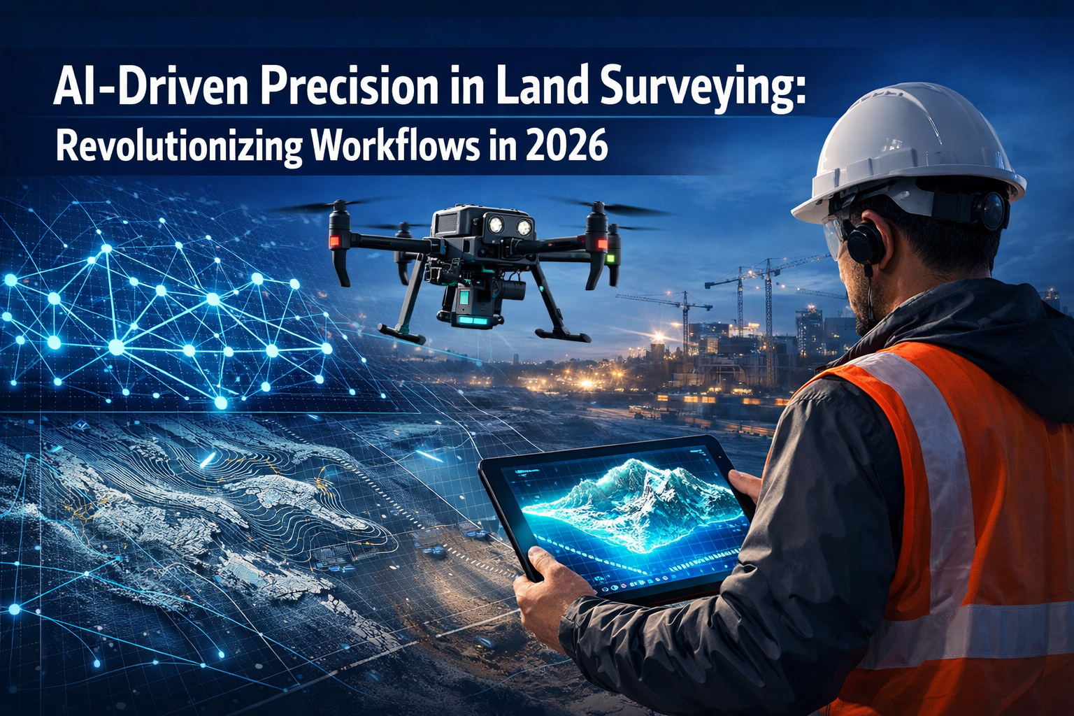
The land surveying profession stands at a pivotal moment in 2026. What once required weeks of manual data processing, multiple site visits, and extensive quality control checks now happens in hours—sometimes minutes. AI-Driven Precision in Land Surveying: Revolutionizing Workflows in 2026 represents more than incremental improvement; it marks a fundamental transformation in how spatial data is captured, processed, and delivered to clients. Surveying professionals who once spent 70% of their time processing raw field data now dedicate that time to specialized analysis and strategic consultation, while artificial intelligence handles the repetitive computational tasks with unprecedented accuracy.
This revolution isn't happening in research laboratories or theoretical white papers. It's occurring on construction sites, boundary surveys, infrastructure projects, and commercial developments across the globe. The integration of AI into core surveying workflows has moved from experimental to essential, with 94% of surveying professionals planning to increase AI usage in 2026[6].
Key Takeaways
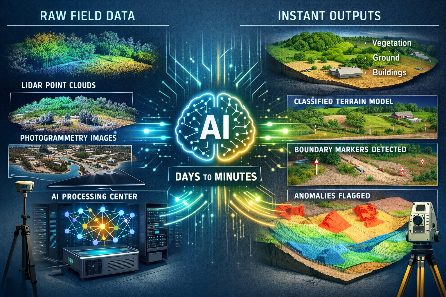
✅ AI systems now automatically classify terrain, identify markers, and flag anomalies without manual intervention, reducing data processing time from days to hours while improving accuracy standards[1].
✅ Multi-sensor drone arrays capture comprehensive site data in a single flight, integrating LiDAR, photogrammetry, multispectral, and thermal imaging that previously required multiple site visits[1].
✅ Real-time 3D digital twins have become standard premium deliverables for commercial projects, enabling continuous updates, predictive modeling, and collaborative visualization across project teams[1].
✅ 94% of surveying professionals plan to increase AI adoption in 2026, representing near-universal recognition of AI's transformative impact on workflow efficiency and competitive positioning[6].
✅ Cloud-based collaboration platforms are replacing static document delivery, meeting evolving client expectations for instant access, browser-based visualization, and integrated communication with all project stakeholders[1].
Understanding AI-Driven Precision in Land Surveying: Revolutionizing Workflows in 2026
The Shift from Manual to Automated Data Processing
Traditional land surveying workflows followed a predictable but time-intensive pattern. Field crews collected raw data using total stations, GPS receivers, and measuring equipment. Back at the office, technicians spent days processing this information, manually classifying terrain features, identifying control points, and creating preliminary models. Quality control required additional rounds of review, often revealing errors that necessitated return site visits.
AI has fundamentally disrupted this linear workflow. Modern surveying systems now embed artificial intelligence directly into the data capture and processing pipeline. As field data streams from sensors, AI algorithms instantly:
- Classify terrain types based on elevation patterns, surface characteristics, and contextual analysis
- Identify boundary markers and control points using computer vision trained on thousands of reference images
- Flag anomalies and inconsistencies that fall outside expected parameters for the project type
- Generate preliminary surface models with topographic detail and accuracy metrics
- Alert surveyors to data gaps requiring additional coverage before leaving the site
This real-time processing capability transforms field operations. Surveyors receive immediate feedback on data quality and completeness while still on-site, eliminating costly return visits. What previously required a week of office processing now completes during the drive back from the field[1].
Quality Assurance Through AI-Assisted Error Detection
Quality control represents one of surveying's most critical yet time-consuming responsibilities. Traditional QA processes relied on experienced surveyors manually reviewing datasets, cross-referencing measurements, and identifying discrepancies. This manual approach, while thorough, introduced human error and created bottlenecks in project timelines.
AI-assisted quality checks are now integrated into production pipelines at forward-thinking surveying firms. These systems apply machine learning models trained on millions of surveying projects to detect patterns that indicate potential errors:
🔍 Measurement inconsistencies that fall outside statistical norms for the equipment and conditions
🔍 Coordinate discrepancies between overlapping survey areas that suggest calibration issues
🔍 Geometric impossibilities in boundary descriptions or elevation models
🔍 Data density variations that indicate incomplete coverage of critical areas
The system alerts surveyors to these issues before projects reach the drafting stage, fundamentally improving accuracy standards while reducing revision cycles. Firms implementing AI quality assurance report 30-40% reduction in post-delivery corrections and significantly higher client satisfaction scores[1].
Real-World Implementation: Case Studies from 2026
The theoretical benefits of AI in surveying become tangible when examining real-world implementations. A commercial development project in Surrey demonstrates the practical impact of AI-Driven Precision in Land Surveying: Revolutionizing Workflows in 2026.
The project involved surveying a 15-hectare mixed-use development site with complex topography, existing structures, and environmental constraints. Traditional surveying methods would have required:
- 5-7 site visits for comprehensive data collection
- 3-4 weeks of data processing and model generation
- 2-3 revision cycles to address quality issues and client feedback
- Total timeline: 8-10 weeks from initial site visit to final deliverable
Using AI-integrated workflows with multi-sensor drone arrays and automated processing, the same project completed in:
- 1 comprehensive site visit capturing all required data
- 48 hours for AI-processed preliminary models and quality checks
- 1 revision cycle for client-requested adjustments
- Total timeline: 2 weeks from site visit to final deliverable
The cost savings extended beyond timeline compression. Reduced site visits lowered mobilization costs, fuel expenses, and crew time. Faster turnaround enabled the client to begin design work sooner, accelerating the entire development schedule. The surveying firm reallocated senior staff from data processing to consulting on complex boundary issues and regulatory compliance—higher-value services that strengthened client relationships[1].
Similar implementations across commercial property surveys and infrastructure projects demonstrate consistent patterns: 60-70% timeline reduction, 40-50% cost savings, and measurably improved accuracy compared to traditional workflows.
Advanced Technology Integration: Multi-Sensor Systems and Autonomous Capabilities
Multi-Sensor Drone Arrays: Comprehensive Data Capture
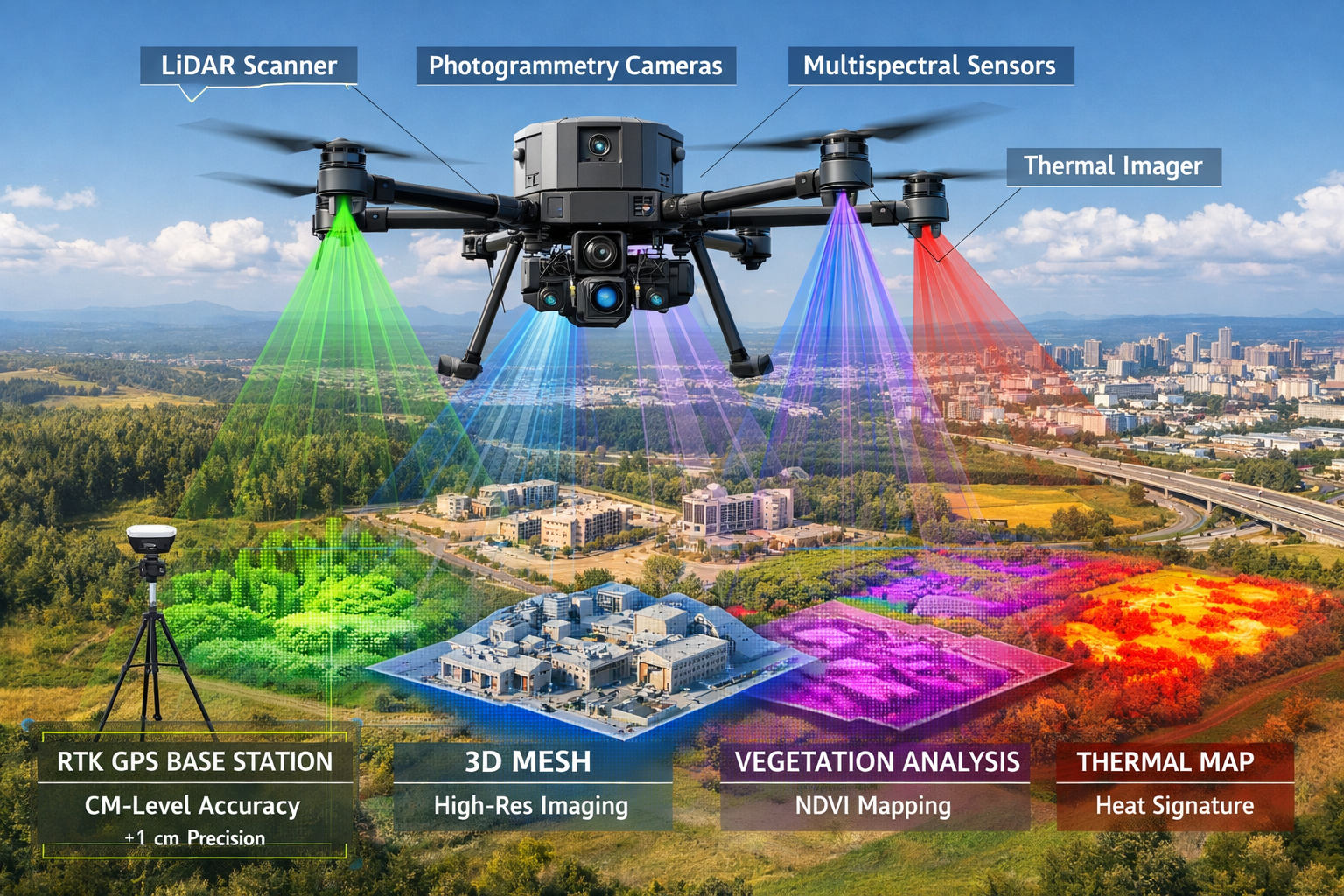
The evolution of drone technology for surveying applications has accelerated dramatically. Early surveying drones carried single cameras for basic photogrammetry. By 2024, dual-sensor systems combining cameras and LiDAR became standard. In 2026, multi-sensor drone arrays represent the new baseline for professional surveying operations.
Modern surveying drones integrate four or more sensor types in synchronized operation:
| Sensor Type | Primary Function | Key Benefits |
|---|---|---|
| LiDAR Scanner | Precise elevation mapping | Penetrates vegetation, centimeter-level accuracy, rapid point cloud generation |
| High-Resolution Cameras | Photogrammetry and visual documentation | True-color 3D models, detailed imagery, texture mapping |
| Multispectral Sensors | Vegetation and environmental analysis | Identifies vegetation types, assesses health, monitors environmental changes |
| Thermal Imaging | Heat signature detection | Identifies drainage issues, detects underground utilities, assesses structural integrity |
This sensor integration delivers transformative capabilities. A single flight mission captures data that previously required multiple visits with different equipment. The LiDAR scanner maps terrain elevation with centimeter precision while simultaneously penetrating vegetation to reveal ground surface. High-resolution cameras capture visual detail for photogrammetric modeling and documentation. Multispectral sensors identify vegetation patterns and environmental features. Thermal imaging reveals subsurface conditions and potential issues invisible to standard cameras[1].
The synchronized operation of these sensors creates comprehensive datasets that support multiple analysis types from a single collection event. This efficiency dramatically reduces project timelines and costs while improving data quality through temporal consistency—all measurements captured under identical environmental conditions.
Autonomous Flight Planning and Adaptive Data Collection
Early surveying drones required skilled pilots to manually plan flight paths, adjust altitude for terrain variations, and ensure adequate coverage. Modern systems incorporate autonomous capabilities with predictive modeling that revolutionize field operations.
AI-powered flight planning systems analyze project requirements, site characteristics, and environmental conditions to automatically generate optimal flight paths. The system considers:
- Terrain complexity and elevation variations requiring altitude adjustments
- Desired accuracy levels dictating flight height and overlap percentages
- Sensor capabilities and optimal operating parameters for each sensor type
- Environmental factors including lighting conditions, wind patterns, and obstacles
- Regulatory constraints such as airspace restrictions and privacy considerations
During flight operations, the drone continuously analyzes incoming data quality in real-time. If the system detects insufficient coverage, unexpected obstacles, or data quality issues, it automatically adjusts altitude, angle, and sensor selection to achieve optimal readings. This adaptive capability ensures comprehensive data capture without requiring manual intervention or return visits[1].
The practical impact is substantial. Surveyors with limited drone piloting experience can deploy sophisticated autonomous systems with confidence. Complex sites that previously required expert pilots and multiple flight attempts now complete successfully on the first mission. The technology democratizes access to advanced surveying capabilities across firms of all sizes.
RTK GPS: Centimeter-Level Precision in Positioning
While AI and drones capture attention, the foundation of surveying precision remains accurate positioning. RTK (Real-Time Kinematic) GPS systems deliver centimeter-level precision that makes modern surveying workflows possible.
Standard consumer GPS receivers achieve accuracy of 3-5 meters under ideal conditions—insufficient for professional surveying requirements. RTK systems employ a different approach using fixed base station receivers and roving units to correct satellite signal discrepancies in real-time[2].
The RTK base station occupies a precisely surveyed control point, continuously receiving signals from GPS satellites. By comparing the known position with satellite-calculated position, the base station determines correction factors for atmospheric interference, satellite orbit variations, and signal delays. These corrections transmit to roving GPS units in real-time, enabling them to calculate positions with centimeter-level accuracy in clear sky conditions[2].
This precision enables several critical capabilities:
📍 Accurate georeferencing of drone imagery and LiDAR data to real-world coordinates
📍 Precise control point establishment for large-scale surveying projects
📍 Real-time positioning of field crews for efficient data collection
📍 Quality verification through independent measurement of known control points
Modern RTK systems integrate seamlessly with AI-powered surveying workflows. Drone-mounted RTK receivers georeference sensor data during flight, eliminating time-consuming post-processing steps. Ground crews use RTK rovers to establish control points and verify critical measurements. The combination of RTK precision and AI processing creates workflows that are both fast and accurate—previously competing priorities that now complement each other[2].
Transforming Client Deliverables: Digital Twins and Cloud Collaboration
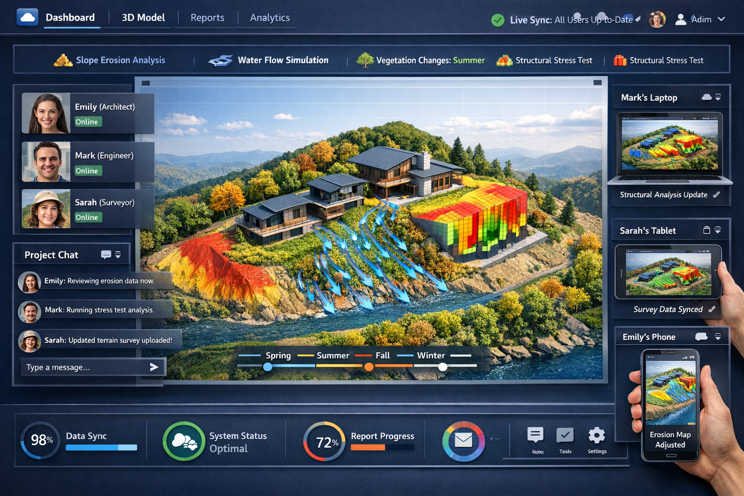
Real-Time 3D Digital Twins as Standard Premium Deliverables
Client expectations for surveying deliverables have evolved dramatically. Traditional outputs—printed plans, static PDF documents, and basic CAD files—no longer meet the needs of modern development projects. Real-time 3D digital twins are emerging as standard premium deliverables in 2026, particularly for commercial development projects[1].
Digital twins represent comprehensive virtual replicas of physical sites, combining multiple data layers into interactive 3D models. These models incorporate:
- High-resolution 3D terrain from LiDAR and photogrammetry data
- True-color textures from aerial and ground-based photography
- Accurate measurements and spatial relationships between features
- Environmental data including vegetation, water features, and existing structures
- Infrastructure elements such as utilities, roads, and buildings
The "real-time" aspect distinguishes modern digital twins from static 3D models. As new survey data becomes available, the digital twin updates continuously to reflect current site conditions. This capability proves invaluable for:
🏗️ Active construction monitoring tracking progress against design specifications
🏗️ Environmental change detection identifying erosion, vegetation growth, or drainage issues
🏗️ Infrastructure maintenance documenting condition changes over time
🏗️ Regulatory compliance providing objective evidence of site conditions
Beyond visualization, digital twins enable sophisticated predictive modeling and analysis. Modern platforms integrate simulation capabilities that allow stakeholders to:
- Project slope erosion patterns under various weather scenarios
- Simulate water flow and drainage performance
- Visualize vegetation pattern changes across seasons
- Test infrastructure stress under different load conditions
These analytical capabilities transform surveying from documentation service to strategic consulting. Developers use erosion projections to optimize grading plans. Engineers simulate drainage scenarios to validate design assumptions. Environmental consultants model vegetation changes to ensure regulatory compliance. The digital twin becomes a central decision-making tool throughout the project lifecycle[1].
Cloud-Based Collaboration Platforms Replace Static Delivery
The shift from static documents to interactive digital twins requires corresponding evolution in delivery mechanisms. Cloud-based collaboration platforms are replacing traditional static document delivery as client expectations shift toward instant access and real-time collaboration[1].
Modern surveying platforms provide:
✨ Instant file sharing with automatic version control and change tracking
✨ Browser-based 3D visualization requiring no specialized software installation
✨ Real-time revision syncing ensuring all stakeholders access current information
✨ Integrated communication with architects, engineers, and other project team members
✨ Mobile device compatibility enabling field access to survey data and models
✨ Granular permission controls managing access to sensitive information
The collaborative aspect fundamentally changes project workflows. Rather than sequential handoffs—surveyor completes work, delivers to architect, who delivers to engineer—all parties access the evolving digital twin simultaneously. When the surveyor updates elevation data, the architect's site plan reflects changes immediately. When the engineer identifies a drainage concern, the surveyor receives notification and can target additional data collection.
This parallel workflow acceleration dramatically compresses project timelines. A commercial dilapidation survey that traditionally required weeks of sequential review cycles now progresses with all stakeholders working simultaneously from shared data. Design iterations happen in days rather than weeks. Issues identified early prevent costly rework later in the project.
The platform approach also enhances client relationships. Rather than periodic deliverables at project milestones, clients maintain continuous visibility into survey progress. They can explore preliminary data as it becomes available, provide feedback early, and make informed decisions without waiting for formal deliverable packages. This transparency builds trust and positions surveyors as collaborative partners rather than external service providers.
Democratization of Reality Capture Technology
Advanced surveying technology has historically required significant capital investment and specialized expertise, creating barriers for smaller firms and limiting adoption. That dynamic is shifting in 2026 as reality capture technology becomes democratized through user-friendly tools.
Arnaud Lezennec, senior applications engineer at Trimble, observes that new accessibility "enables comprehensive data collection, in-field treatment, and faster decision-making, with capture capabilities extending to mobile phones and mobile mapping systems"[5]. This democratization manifests in several ways:
📱 Mobile device integration allowing smartphones and tablets to capture survey-grade data using built-in sensors enhanced by AI processing
📱 Simplified user interfaces that guide operators through complex workflows with minimal training
📱 Automated processing pipelines handling technical tasks that previously required specialized expertise
📱 Affordable entry-level systems bringing professional capabilities within reach of smaller firms
📱 Cloud-based processing eliminating requirements for expensive local computing infrastructure
The implications extend beyond cost reduction. Broader access to advanced tools accelerates innovation as more professionals experiment with new applications and workflows. Smaller firms compete more effectively with larger competitors, driving service quality improvements across the industry. Clients benefit from increased competition and broader access to sophisticated surveying services.
This democratization also addresses critical workforce challenges. As experienced surveyors retire, user-friendly technology enables newer professionals to achieve productivity levels that previously required years of training. The technology doesn't replace expertise—it amplifies it, allowing professionals to focus on judgment and analysis rather than technical mechanics.
Industry Transformation: Workforce, Adoption Rates, and Future Trajectories
Addressing Workforce Shortages Through Technology
The surveying profession faces significant demographic challenges. Experienced professionals are retiring faster than new talent enters the field. Complex projects require specialized expertise that takes years to develop. Traditional training pathways struggle to keep pace with technological evolution. These workforce pressures create both challenges and opportunities for AI-Driven Precision in Land Surveying: Revolutionizing Workflows in 2026.
Workforce shortage mitigation through technology and automation has become a strategic priority across the industry. Drones and aerial surveying play a critical role in filling labor gaps by enabling smaller crews to accomplish work that previously required larger teams[4]. A comprehensive topographic survey that once required a four-person crew working multiple days now completes with two people and a drone in a single day.
AI amplifies this efficiency by automating tasks that traditionally required experienced judgment:
- Terrain classification that previously relied on surveyor expertise now happens automatically with AI analyzing elevation patterns and surface characteristics
- Quality control checks that required senior surveyor review now occur through AI-assisted error detection systems
- Preliminary modeling that demanded CAD expertise now generates automatically from processed field data
- Anomaly detection that depended on experienced eyes now triggers through AI pattern recognition
This automation doesn't eliminate the need for professional surveyors—it changes what they do. Rather than spending time on routine data processing, professionals focus on:
🎯 Complex problem-solving requiring professional judgment and experience
🎯 Client consultation on regulatory compliance, boundary disputes, and strategic planning
🎯 Quality oversight reviewing AI-generated outputs and making final determinations
🎯 Specialized analysis applying expertise to unique situations beyond AI capabilities
The technology enables firms to accomplish more with existing staff while making the profession more attractive to new talent. Younger professionals drawn to technology careers find modern surveying more appealing than traditional perceptions of the field suggest. The combination of outdoor fieldwork, advanced technology, and meaningful problem-solving creates compelling career pathways.
Near-Universal Adoption Intent: The 94% Statistic
Industry adoption rates provide clear evidence of AI's transformative impact. According to research conducted in late 2025, 94% of surveying professionals plan to increase AI usage in 2026[6]. This represents near-universal recognition that AI integration is not optional for competitive firms.
The adoption intent spans firm sizes, service specializations, and geographic regions. Small practices see AI as an equalizer enabling them to compete with larger competitors. Mid-sized firms view AI as essential for scaling operations without proportional staff increases. Large enterprises recognize AI as necessary for maintaining market leadership and meeting evolving client expectations.
Several factors drive this extraordinary adoption rate:
Competitive pressure from early adopters demonstrating superior efficiency and accuracy creates urgency for firms still using traditional workflows. Clients increasingly expect AI-enhanced deliverables and faster turnaround times.
Technology maturity has reached the point where AI tools integrate seamlessly into existing workflows rather than requiring complete process redesign. Implementation barriers have decreased substantially from early experimental systems.
Demonstrated ROI from successful implementations provides clear business justification. Firms report measurable improvements in project profitability, client retention, and competitive win rates.
Workforce realities make AI adoption necessary rather than optional. Technology enables firms to maintain service levels despite difficulty recruiting experienced professionals.
Client expectations continue evolving toward sophisticated deliverables like digital twins and real-time collaboration platforms that depend on AI-powered processing.
The 94% adoption intent suggests the industry has reached a tipping point. AI integration is transitioning from competitive advantage to baseline expectation. Firms not investing in AI capabilities risk becoming unable to compete for premium projects and sophisticated clients.
Digital Transformation Acceleration and Future Trajectories
The surveying industry's digital transformation is accelerating under pressure to deliver faster, more accurate results while managing workforce shortages and evolving client expectations. The convergence of AI, cloud-based platforms, and interoperable hardware/software is fundamentally reshaping spatial data capture, processing, and sharing[5].
Looking forward from 2026, several trajectories appear clear:
Continued sensor integration will expand beyond current multi-sensor arrays to include additional capabilities like ground-penetrating radar, atmospheric sensors, and advanced spectral analysis. Comprehensive environmental characterization will become standard rather than specialized.
AI sophistication will advance from current pattern recognition and automation to predictive modeling and autonomous decision-making. Systems will not just process data but recommend optimal survey approaches, identify potential issues before they occur, and suggest design improvements based on site analysis.
Real-time collaboration will evolve beyond current cloud platforms to include augmented reality visualization enabling stakeholders to experience survey data overlaid on physical sites. Design reviews will happen on-site with all parties viewing proposed changes in context.
Regulatory integration will see AI systems automatically checking survey outputs against local regulations, zoning requirements, and building codes, flagging compliance issues before submission to authorities.
Blockchain verification may emerge for survey data authentication, creating immutable records of measurements and establishing clear chains of custody for critical boundary determinations.
Autonomous field operations could advance to fully automated survey missions with minimal human supervision for routine projects, freeing professionals to focus entirely on complex situations requiring judgment.
These trajectories suggest an industry fundamentally transformed from current practice. The surveyor's role continues evolving from technician to consultant, from data collector to strategic advisor. Technology handles routine tasks with increasing sophistication while human expertise focuses on judgment, client relationships, and complex problem-solving.
Firms positioning themselves at the forefront of this transformation—investing in technology, training staff, and reimagining service delivery—will capture premium market segments and build sustainable competitive advantages. Those treating AI as optional or delaying adoption risk marginalization as client expectations and competitive dynamics leave traditional approaches behind.
Practical Implementation: Getting Started with AI Integration
Assessing Current Workflows and Identifying Opportunities
For surveying firms ready to embrace AI-Driven Precision in Land Surveying: Revolutionizing Workflows in 2026, the first step involves honest assessment of current workflows. Where do bottlenecks occur? Which tasks consume disproportionate time relative to value delivered? What client complaints or feedback suggest opportunities for improvement?
Common pain points suitable for AI intervention include:
⚙️ Data processing backlogs where field crews collect data faster than office staff can process it
⚙️ Quality control bottlenecks requiring senior staff review that delays project completion
⚙️ Revision cycles caused by errors or inconsistencies discovered late in the process
⚙️ Client communication gaps during projects with limited visibility into progress
⚙️ Specialized analysis requiring expertise that's scarce or expensive to access
Identifying these pain points guides technology selection and implementation priorities. A firm struggling with processing backlogs should prioritize AI-powered automated processing. One facing quality issues should focus on AI-assisted error detection. A practice with communication challenges should emphasize cloud collaboration platforms.
Selecting Appropriate Technology Partners and Solutions
The surveying technology market offers numerous AI-enhanced solutions with varying capabilities, costs, and integration requirements. Selecting appropriate partners requires careful evaluation:
Integration compatibility with existing hardware and software ecosystems determines implementation complexity. Solutions that work with current equipment and data formats reduce transition friction.
Scalability ensures the technology grows with the firm. Entry-level systems should offer upgrade paths to more sophisticated capabilities as needs evolve.
Training and support quality varies significantly between vendors. Comprehensive training programs and responsive technical support accelerate adoption and maximize return on investment.
Industry specialization matters for solutions targeting specific survey types. A system optimized for drone roof surveys may differ from one designed for large-scale topographic work.
User community size and engagement indicate solution maturity and ongoing development commitment. Active user communities provide peer support and share best practices.
Vendor stability and long-term viability ensure continued support and development. Emerging startups may offer innovative features but carry higher risk than established vendors.
Many firms benefit from phased implementation starting with specific project types or workflows rather than attempting comprehensive transformation simultaneously. Success with initial implementations builds internal expertise and confidence for expanding AI integration across the practice.
Training Staff and Managing Change
Technology adoption succeeds or fails based on people, not just systems. Staff training and change management determine whether AI investments deliver promised benefits or become expensive unused capabilities.
Effective training programs address multiple learning styles and experience levels:
Hands-on workshops allow staff to experiment with new systems in controlled environments before deploying on client projects
Mentorship pairing experienced staff with newer team members accelerates knowledge transfer and builds confidence
Ongoing education through webinars, conferences, and vendor training keeps skills current as technology evolves
Documentation and resources provide reference materials for troubleshooting and refreshing knowledge
Certification programs validate competency and create professional development pathways
Change management extends beyond technical training to address cultural and process dimensions. Staff may resist AI adoption due to concerns about job security, skepticism about technology benefits, or comfort with familiar workflows. Addressing these concerns requires:
💬 Transparent communication about why AI adoption is necessary and how it benefits both the firm and individual staff members
💬 Involvement in planning giving staff voice in technology selection and implementation approaches
💬 Celebrating successes highlighting early wins and recognizing individuals who embrace new approaches
💬 Patience with setbacks acknowledging that learning curves are normal and mistakes are part of the process
💬 Career development clarity showing how AI skills create opportunities rather than threatening employment
Firms that invest adequately in training and change management realize technology benefits faster and more completely than those focusing solely on hardware and software acquisition.
Conclusion: Embracing the AI Revolution in Land Surveying
AI-Driven Precision in Land Surveying: Revolutionizing Workflows in 2026 represents far more than technological novelty—it marks a fundamental transformation in how surveying professionals deliver value to clients. The integration of artificial intelligence into core workflows, combined with multi-sensor drone arrays, RTK precision positioning, and cloud-based collaboration platforms, has created capabilities unimaginable just years ago.
The evidence is compelling: 94% adoption intent, 60-70% timeline reductions, 40-50% cost savings, and measurably improved accuracy[1][6]. These aren't projections or aspirations—they're documented outcomes from firms already operating at the forefront of this transformation.
For surveying professionals, the path forward is clear. AI integration is no longer optional for firms seeking to remain competitive, attract premium clients, and provide career opportunities that appeal to emerging talent. The technology has matured beyond experimental status to become reliable, accessible, and essential.
Actionable Next Steps
For firms ready to embrace AI-driven precision in their surveying workflows:
-
Conduct a workflow audit identifying specific pain points where AI can deliver immediate value
-
Research technology solutions appropriate for your practice size, specialization, and client base
-
Start with pilot projects testing AI capabilities on non-critical work before full deployment
-
Invest in comprehensive training ensuring staff develop competency and confidence with new systems
-
Engage with industry peers learning from others' experiences through professional associations and user communities
-
Communicate value to clients educating them about enhanced capabilities and deliverables
-
Monitor results and refine tracking metrics to validate ROI and identify optimization opportunities
For clients seeking surveying services, the implications are equally significant. When evaluating surveying firms for your next project—whether a boundary survey, commercial development, or infrastructure assessment—inquire about their AI capabilities, multi-sensor systems, and digital deliverables. Firms investing in these technologies demonstrate commitment to accuracy, efficiency, and client service that translates directly into project value.
The revolution in land surveying isn't coming—it's here. The question isn't whether to adopt AI-driven precision, but how quickly firms can implement these capabilities to serve clients better, empower their staff, and build sustainable competitive advantages in an industry transformed by technology.
The future of surveying combines the irreplaceable judgment and expertise of skilled professionals with the processing power, pattern recognition, and automation capabilities of artificial intelligence. This partnership between human expertise and machine capability creates outcomes superior to either alone—faster, more accurate, more comprehensive, and more valuable to the clients and communities that depend on precise spatial information.
As 2026 unfolds, the firms thriving in this transformed landscape will be those that embraced change early, invested in technology and training, and reimagined their service delivery for a digital future. The opportunity is substantial, the tools are available, and the path forward is clear. The time to act is now.
References
[1] Future Land Surveying 2026 – https://haller-blanchard.com/future-land-surveying-2026/
[2] How Technology Is Revolutionizing Land Surveys – https://www.firstchoicesurveying.com/blog/how-technology-is-revolutionizing-land-surveys
[3] Top Emerging Land Surveying Technologies Shaping 2026 Drones Ai And Beyond – https://nottinghillsurveyors.com/blog/top-emerging-land-surveying-technologies-shaping-2026-drones-ai-and-beyond
[4] Watch – https://www.youtube.com/watch?v=CSTodaZb4Vc
[5] Doubling Down On Digital – https://amerisurv.com/2026/02/01/doubling-down-on-digital/
[6] Architecture Engineering Construction Sector Slow To Adapt Ai Survey Shows – https://www.asce.org/publications-and-news/civil-engineering-source/article/2025/12/18/architecture-engineering-construction-sector-slow-to-adapt-ai-survey-shows