Understanding Land Survey Costs in 2026: Factors Driving Increases and How to Budget Smartly has become essential for property owners, developers, and homebuyers navigating today's real estate landscape. With national average costs now sitting at $2,300 and ranges spanning from $475 to $25,000, the financial commitment required for professional land surveys demands careful planning and strategic decision-making[3][4].
The surveying industry has experienced notable shifts over the past few years, driven by inflation, technological advancement, construction market dynamics, and evolving regulatory requirements. Property owners who approach survey costs with knowledge and preparation can save thousands of dollars while ensuring they receive accurate, comprehensive results that protect their investments.
This comprehensive guide examines the economic forces shaping survey pricing in 2026, breaks down the specific factors that influence your final bill, and provides actionable strategies for budgeting effectively without compromising on quality or accuracy.
Key Takeaways
- 📊 National average land survey costs have reached $2,300 in 2026, with typical ranges from $475 to $25,000 depending on property characteristics and survey complexity[3][4]
- 🏗️ Property size remains the dominant cost factor, with pricing tiers ranging from under $1,000 for small lots to $10,000-$25,000 for 50-acre parcels[3]
- 💰 Hourly surveyor rates now range from $220 to $450, reflecting increased operational costs, advanced technology investments, and specialized expertise requirements[3]
- 🌍 Geographic location creates substantial price variations, with urban markets like New York and San Francisco commanding premium rates compared to rural regions[1][3]
- 🎯 Strategic planning and informed decision-making can reduce survey costs by 20-40% through timing optimization, record preparation, and competitive bidding
Understanding the 2026 Land Survey Market Landscape
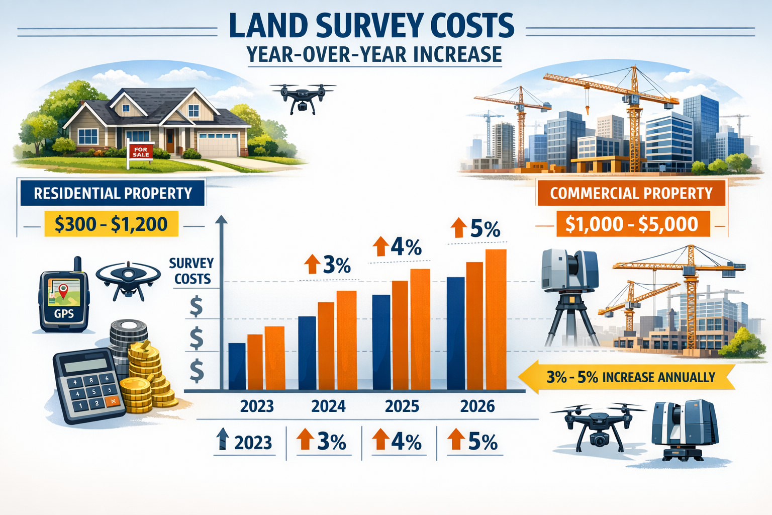
Year-Over-Year Cost Comparisons and Inflation Impact
The land surveying industry has experienced modest but consistent cost increases from 2023 through 2026, primarily driven by broader economic inflation and rising operational expenses[1]. While basic surveys have maintained relatively stable pricing structures, specialized services have seen more pronounced increases due to technological advancement requirements and regulatory compliance demands.
Comparing 2026 costs to previous years reveals several important trends:
| Survey Type | 2023 Average | 2026 Average | Percentage Increase |
|---|---|---|---|
| Basic Boundary Survey | $950 | $1,200 | 26.3% |
| Topographic Survey | $1,800 | $2,000 | 11.1% |
| ALTA/NSPS Survey | $4,200 | $5,000 | 19.0% |
| New Construction Survey | $2,800 | $3,200 | 14.3% |
These increases reflect not only general inflation but also the premium costs associated with modern surveying technology, including GPS equipment, drone systems, and advanced data processing software that have become industry standards[7].
Construction Boom Effects on Survey Demand
The ongoing construction boom across residential and commercial sectors has created unprecedented demand for surveying services in 2026. This heightened demand has influenced pricing in several ways:
Supply and demand dynamics have tightened surveyor availability, particularly in rapidly developing regions. Property owners in high-growth areas may face:
- Extended wait times of 4-8 weeks for survey completion
- Premium pricing during peak construction seasons (spring and summer)
- Limited negotiation flexibility due to surveyor workload capacity
- Increased costs for expedited services
The construction industry's robust activity has also elevated the need for specialized surveys, including boundary surveys that establish precise property lines before development begins.
Technology Premium: Modern Equipment and Expertise
Modern land surveying has evolved dramatically from traditional chain-and-compass methods to sophisticated GPS-enabled total stations, aerial drone mapping, and 3D laser scanning technology[7]. While these advancements deliver superior accuracy and efficiency, they also contribute to higher service costs.
Surveyors investing in cutting-edge equipment must recover these costs through their pricing structures:
- GPS surveying systems: $15,000-$50,000 per unit
- Professional-grade drones with LiDAR: $20,000-$100,000
- 3D laser scanning equipment: $30,000-$150,000
- Advanced data processing software: $5,000-$15,000 annually
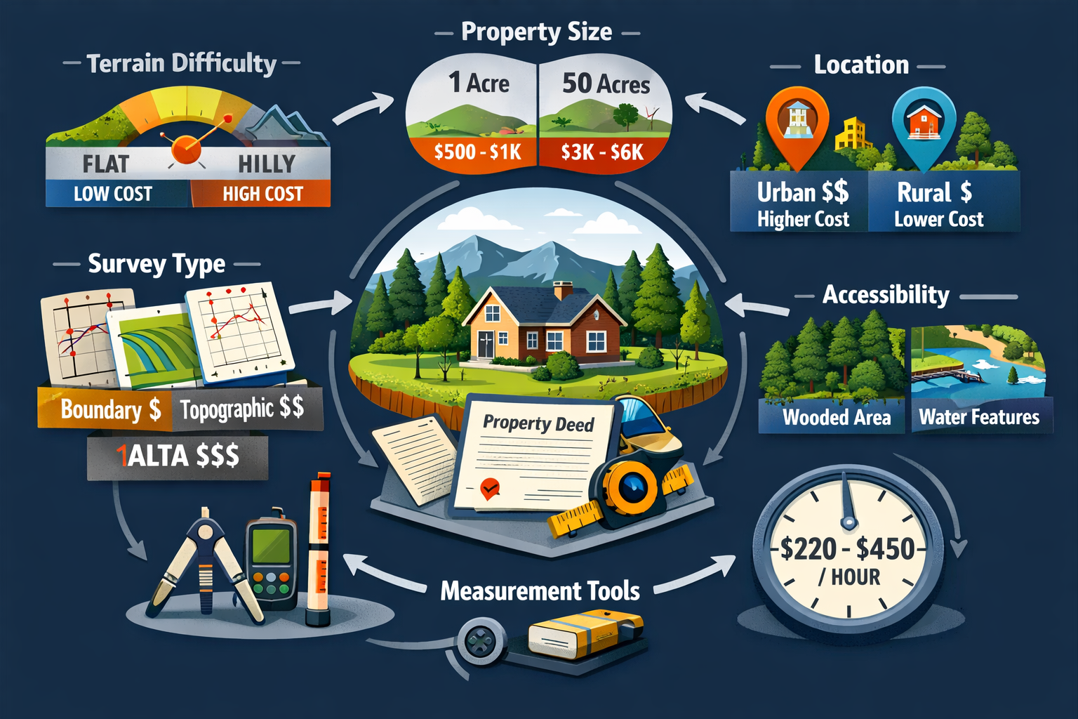
The expertise required to operate this technology also commands premium rates. Surveyors with specialized certifications and technological proficiency typically charge at the higher end of the $220-$450 hourly rate spectrum[3].
Breaking Down Land Survey Costs in 2026: Factors Driving Increases
Property Size: The Primary Cost Determinant
Property acreage represents the single most influential factor in determining land survey costs. The relationship between property size and survey expenses follows a predictable pattern, though not strictly linear due to economies of scale[3]:
Property Size Cost Breakdown:
- Less than 1 acre: $1,000 or less
- 1 acre: $1,500-$3,500
- 5 acres: $2,500-$4,400
- 10 acres: $3,600-$6,500
- 25 acres: $5,500-$12,000
- 50 acres: $10,000-$25,000
These ranges reflect the time investment required to physically traverse, measure, and document larger properties. A suburban residential lot measuring 0.25 acres might require 4-6 hours of fieldwork, while a 50-acre rural parcel could demand several days of surveying activity.
Survey Type and Complexity Requirements
Different survey types serve distinct purposes and require varying levels of detail, directly impacting costs. Understanding these distinctions helps property owners select the appropriate survey for their specific needs without overpaying for unnecessary services.
Common Survey Types and Their 2026 Cost Ranges:
🏘️ Boundary Survey ($1,200-$5,500): Establishes precise property lines and corner markers, essential for fence installation, property disputes, or pre-sale verification. This represents the most commonly requested residential survey type.
🗺️ Topographic Survey ($2,000-$6,500): Maps elevation changes, natural features, and existing structures. Critical for development projects, drainage planning, and construction design. Residential topographic surveys typically cost $500-$2,500[1].
📋 ALTA/NSPS Survey ($2,500-$10,000): Comprehensive commercial survey meeting American Land Title Association standards, including detailed improvements, easements, and encroachments. Required for commercial real estate transactions and title insurance.
🏗️ New Construction Survey ($1,800-$6,500): Verifies that buildings are constructed within property boundaries and comply with setback requirements. Often required by municipalities before issuing certificates of occupancy.
For specialized needs, chartered surveyors can provide expert guidance on selecting the most appropriate survey type for your situation.
Geographic Location and Regional Market Variations
Location dramatically influences survey pricing, with urban markets commanding substantial premiums over rural areas[1][3]. This disparity reflects several factors:
Urban Premium Factors:
- Higher cost of living and business operation
- Increased property values justifying premium services
- Complex regulatory environments requiring additional documentation
- Limited surveyor availability relative to demand
- Challenging access and parking constraints
Regional Cost Comparison (2026):
| Region/City | Basic Survey Range | Average Cost |
|---|---|---|
| New York City | $1,400-$6,000 | $3,200 |
| California (Major Cities) | $1,200-$5,600 | $2,900 |
| San Francisco | $1,500-$6,500 | $3,500 |
| Texas (Urban) | $800-$3,500 | $1,800 |
| Rural Midwest | $500-$2,000 | $1,100 |
| Rural South | $500-$1,800 | $950 |
Property owners in areas like Surrey, Berkshire, or Buckinghamshire should expect pricing that reflects regional market conditions and local surveyor availability.
Terrain Difficulty and Property Accessibility
Physical property characteristics significantly impact survey costs through their effect on time requirements and equipment needs. Surveyors must account for these challenges when estimating project scope:
Terrain Complexity Factors:
⛰️ Steep slopes and elevation changes: Require additional time for measurements and may necessitate specialized equipment, increasing costs by 20-40%.
🌲 Dense vegetation: Overgrown properties demand clearing work before accurate measurements can be taken, potentially adding $200-$800 to base costs.
💧 Water features: Streams, ponds, or wetlands complicate boundary establishment and may require environmental compliance documentation.
🏚️ Existing structures: Buildings, fences, and improvements near property lines require careful documentation and increase survey complexity.
🚧 Access limitations: Properties without road access or those requiring special permission to enter neighboring lands create logistical challenges.
Properties with irregular shapes or numerous boundary corners also increase costs, as each corner requires precise measurement and documentation.
Property Record Research and Documentation
Record availability dramatically affects final survey costs. When surveyors can easily locate deed records, historical surveys, and boundary documentation, they can complete projects more efficiently[3].
Record Research Cost Components:
- Property record research: $85-$160 per hour
- County deed office searches: 2-6 hours typically required
- Historical survey location: $150-$400 if previous surveys exist
- Title research coordination: $100-$300 for complex properties
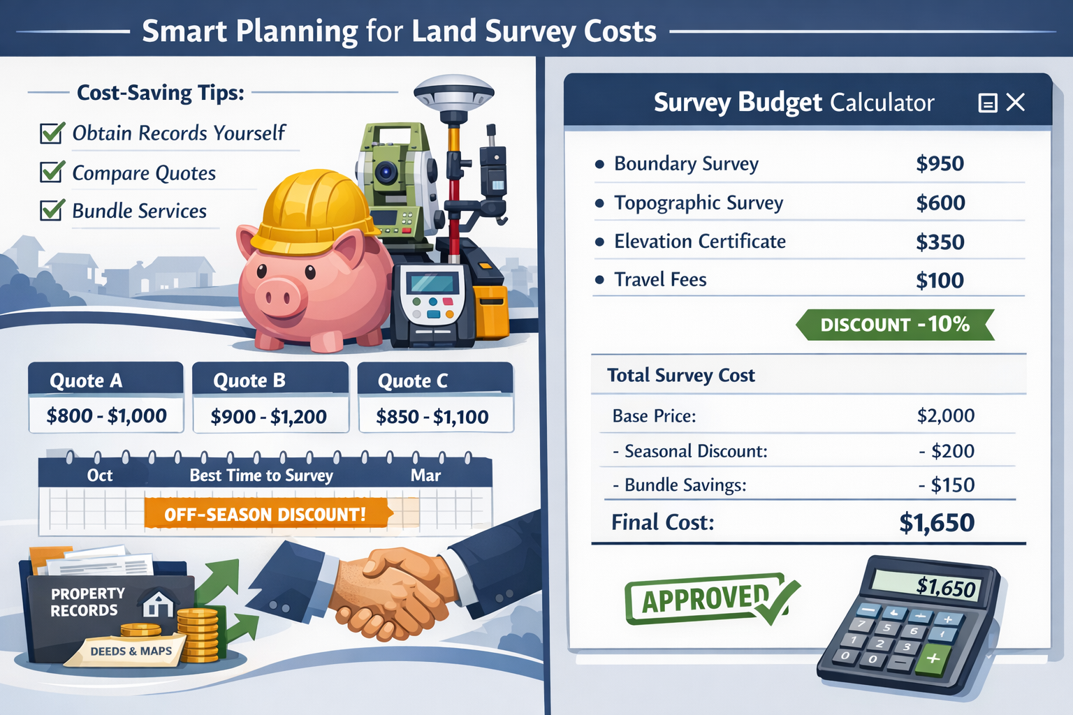
Property owners can reduce these costs significantly by obtaining records directly from county offices before engaging a surveyor. Most county recorder offices provide deed copies for $10-$50, representing substantial savings compared to surveyor research time billed at $85-$160 hourly[3].
Residential vs. Commercial Survey Pricing
The distinction between residential and commercial surveys creates a notable pricing divide in 2026:
Residential Surveys ($300-$1,200): Designed for homeowners, these surveys typically cover smaller properties with straightforward boundary requirements. Basic residential boundary surveys for suburban lots often fall in the $800-$1,200 range[1][4].
Commercial Surveys ($1,000-$5,000+): Commercial properties require more comprehensive documentation, including:
- Detailed improvement locations
- Easement and right-of-way identification
- Zoning compliance verification
- Parking and setback calculations
- Utility infrastructure mapping
Commercial surveys often require ALTA/NSPS standards, which demand extensive research and documentation beyond typical residential requirements. Businesses seeking commercial property surveyors should budget accordingly for these enhanced requirements.
How to Budget Smartly for Land Survey Costs in 2026
Obtaining and Comparing Multiple Quotes
Competitive bidding remains the most effective strategy for ensuring fair pricing on land survey services. However, the comparison process requires careful attention to ensure you're evaluating equivalent services:
Effective Quote Comparison Strategy:
1️⃣ Request detailed written estimates from at least three licensed surveyors, specifying identical scope requirements for each.
2️⃣ Verify surveyor credentials including professional licensure, insurance coverage, and experience with similar properties.
3️⃣ Compare scope of services rather than price alone—the lowest bid may exclude essential components like monument placement or digital file delivery.
4️⃣ Evaluate turnaround times as rushed surveys may cost 20-50% more than standard scheduling.
5️⃣ Check references and reviews from recent clients with similar property types.
Red Flags to Avoid:
- ⚠️ Quotes significantly below market averages (30%+ lower)
- ⚠️ Surveyors unwilling to provide written estimates
- ⚠️ Lack of professional liability insurance
- ⚠️ Vague scope descriptions without specific deliverables
Timing Your Survey Strategically
Seasonal demand fluctuations create pricing opportunities for flexible property owners. Understanding surveyor workload patterns enables strategic timing that can reduce costs:
Optimal Timing Strategies:
🍂 Fall and Winter Months: Surveyor demand typically decreases from October through February, creating opportunities for negotiated rates and faster scheduling. Some surveyors offer 10-15% discounts during slow periods.
📅 Mid-Week Scheduling: Monday through Wednesday appointments may receive preferential pricing compared to end-of-week requests.
⏰ Off-Peak Hours: Surveyors with flexible scheduling may discount early morning or late afternoon appointments.
🚫 Avoid Peak Periods: Spring and summer construction seasons create maximum demand, reducing negotiation leverage and extending wait times.
However, timing must balance cost savings against project needs—delaying a survey that blocks a real estate closing or construction start date may cost more than premium survey pricing.
Preparing Your Property and Documentation
Proactive preparation reduces surveyor time investment, directly lowering costs. Property owners who invest effort before the surveyor arrives can realize significant savings:
Cost-Reducing Preparation Steps:
📄 Gather existing documentation: Collect property deeds, previous surveys, title reports, and plat maps. Delivering these to your surveyor eliminates research time billed at $85-$160 hourly[3].
🌿 Clear boundary areas: Remove vegetation, debris, and obstacles along suspected property lines. This preparation can save 2-4 hours of surveyor time worth $440-$1,800.
🔍 Locate existing monuments: If previous surveys placed boundary markers, attempt to locate them before the surveyor arrives. Mark their approximate locations with flags.
🗺️ Provide access information: Create a property access map showing gates, locked areas, and optimal entry points. Coordinate with neighbors if boundary access requires crossing adjacent properties.
📋 Compile improvement documentation: Gather building permits, as-built drawings, and construction records for structures near property lines.
These preparation efforts demonstrate professionalism and can position you favorably for negotiated pricing.
Understanding What's Included in Your Survey
Comprehensive understanding of survey deliverables prevents surprise costs and ensures you receive complete value. Standard land surveys should include:
Essential Survey Components:
✅ Field measurements and monumentation: Physical boundary markers placed at property corners (typically iron rods or concrete monuments)
✅ Survey plat or map: Scaled drawing showing property boundaries, dimensions, and relevant features
✅ Written description: Legal description of property boundaries using metes and bounds or lot/block references
✅ Surveyor certification: Professional seal and signature certifying accuracy
✅ Digital file delivery: CAD or PDF files for your records and future reference
Optional Add-Ons (May Increase Cost):
- Elevation certificates for flood insurance
- Tree surveys showing significant vegetation
- Utility location services
- Fence line staking for installation
- Multiple certified copies
Clarify which elements are included in quoted prices versus available as add-ons. Some surveyors bundle comprehensive packages while others price à la carte.
Negotiation Strategies and Cost-Saving Tips
Professional negotiation can reduce survey costs by 10-25% without compromising quality. Effective strategies include:
Proven Negotiation Approaches:
💬 Bundle multiple services: If you need both boundary and topographic surveys, request package pricing. Surveyors often discount combined projects since they're already mobilized on-site.
🤝 Leverage competitive quotes: Professionally present competing estimates and ask if the surveyor can match or beat pricing while maintaining full scope.
📊 Offer flexible scheduling: Indicate willingness to accommodate the surveyor's schedule in exchange for reduced rates during slow periods.
💰 Discuss payment terms: Some surveyors offer small discounts (2-5%) for upfront payment versus installment arrangements.
🔄 Consider repeat business: If you anticipate future survey needs (development projects, additional parcels), mention this potential for ongoing relationship.
What NOT to Negotiate:
- ❌ Professional standards or accuracy requirements
- ❌ Required monumentation or documentation
- ❌ Insurance coverage or liability protection
- ❌ Compliance with regulatory requirements
Quality surveying protects property rights worth far more than survey costs. Negotiate pricing and timing, but never compromise professional standards.
Avoiding Common Budgeting Mistakes
Property owners frequently encounter unexpected survey costs due to preventable planning errors. Awareness of these pitfalls enables better budgeting:
Common Costly Mistakes:
🚨 Underestimating property complexity: Assuming a "simple" survey without consulting professionals often leads to budget overruns when challenges emerge.
🚨 Selecting surveyors solely on price: The cheapest option may deliver inadequate documentation, requiring expensive re-surveys or creating legal vulnerabilities.
🚨 Failing to verify surveyor licensure: Unlicensed practitioners offer low prices but produce legally invalid surveys, wasting your entire investment.
🚨 Ignoring survey type requirements: Ordering a basic boundary survey when lenders or municipalities require ALTA standards necessitates paying for a second survey.
🚨 Delaying survey until transaction deadlines: Rush fees of 25-50% apply when surveyors must prioritize your project over scheduled work.
🚨 Overlooking dispute resolution costs: Properties with boundary disagreements may require specialized dispute resolution services, adding $1,500-$5,000+ to base survey costs.
Leveraging Technology for Cost Efficiency
Modern surveying technology creates both cost increases and potential savings. Understanding these dynamics helps optimize your investment:
Technology-Driven Savings Opportunities:
🛰️ GPS-based surveys: While requiring expensive equipment, GPS technology reduces field time for large properties, potentially lowering costs for parcels exceeding 10 acres.
🚁 Drone mapping: Aerial surveys can reduce costs by 15-30% for large or difficult-to-access properties compared to traditional ground methods.
💻 Digital delivery: Electronic survey files eliminate reproduction costs and enable easy sharing with architects, builders, and government agencies.
📱 Online coordination: Surveyors offering digital communication and document sharing reduce administrative time and associated costs.
However, technology premiums may not benefit small, simple properties where traditional methods remain most cost-effective. Discuss technology options with your surveyor to determine optimal approaches for your specific situation.
Planning for Additional Property Services
Land surveys often represent one component of broader property evaluation needs. Strategic bundling with related services can reduce overall costs:
Complementary Services to Consider:
🏠 Building surveys: If purchasing property, coordinate land surveys with structural surveys to identify potential issues before closing.
🧱 Party wall matters: Properties sharing boundaries with neighbors may require party wall surveyor services, which can be bundled with boundary surveys.
📐 Subsidence investigations: Properties with foundation concerns benefit from combined subsidence surveys and land surveys to comprehensively assess structural and boundary issues.
🏗️ Construction staking: Development projects requiring both initial surveys and ongoing construction layout services often receive package pricing.
Many surveying firms offer multiple services, creating opportunities for bundled discounts of 10-20% compared to engaging separate providers for each need.
Regional Considerations for Land Survey Costs in 2026
Urban vs. Rural Pricing Dynamics
The urban-rural pricing divide extends beyond simple cost-of-living differences to reflect fundamental market structure variations:
Urban Market Characteristics:
- Higher surveyor density but also higher demand
- Smaller average property sizes reducing per-project revenue
- Complex regulatory requirements increasing documentation needs
- Premium pricing for specialized expertise (historic districts, high-density development)
- Limited price competition due to sustained demand
Rural Market Characteristics:
- Fewer surveyors serving larger geographic areas
- Larger average property sizes increasing per-project revenue
- Simpler regulatory environments reducing documentation requirements
- More price-sensitive clients creating competitive pressure
- Travel time and mobilization costs affecting pricing
Property owners in regions like West London, Central London, or South West London should expect urban premium pricing, while those in less densely developed areas may find more competitive rates.
State and Local Regulatory Variations
Regulatory requirements vary significantly by jurisdiction, affecting both survey costs and necessary documentation. Understanding local requirements prevents costly surprises:
Common Regulatory Factors:
📜 State licensing requirements: Some states mandate specific survey types for property transfers, while others leave this to lender or buyer discretion.
🏛️ Municipal recording standards: Local governments may require specific survey formats, scales, or certifications for recording, affecting surveyor preparation time.
🌊 Environmental regulations: Properties near wetlands, floodplains, or protected areas may require additional documentation and certifications.
⚖️ Boundary dispute procedures: States with formal boundary dispute resolution processes may require specific survey formats and expert testimony preparation.
For example, Texas surveying costs reflect that state's specific regulatory environment and market conditions[8]. Consult local surveyors about jurisdiction-specific requirements affecting your project.
Market Demand in High-Growth Regions
Rapidly developing areas experience pronounced survey cost increases due to supply-demand imbalances. High-growth regions share common characteristics:
High-Growth Market Indicators:
- 📈 Sustained population increases exceeding 2% annually
- 🏗️ Active residential and commercial construction pipelines
- 💼 Limited surveyor availability relative to project demand
- ⏰ Extended scheduling timelines (6-12 weeks common)
- 💰 Premium pricing with limited negotiation flexibility
Property owners in these markets should:
- Schedule surveys well in advance of transaction deadlines
- Accept less negotiation leverage on pricing
- Consider off-season timing to improve availability
- Verify surveyor capacity before engaging services
- Budget toward the higher end of regional cost ranges
Conversely, markets experiencing slower growth or economic contraction may offer more competitive pricing and greater negotiation opportunities.
Predicting Future Survey Expense Trends
Inflation Outlook and Cost Projections
Economic forecasting suggests continued modest survey cost increases through 2027-2028, though at potentially slower rates than recent years. Several factors influence this outlook:
Inflationary Pressures:
- General economic inflation affecting operational costs
- Fuel price volatility impacting field work expenses
- Insurance premium increases for professional liability coverage
- Technology investment requirements for competitive service delivery
Moderating Factors:
- Technology efficiency gains reducing time requirements
- Increased surveyor workforce as profession attracts new entrants
- Economic uncertainty potentially dampening construction demand
- Competitive market pressures limiting price increases
Projected Cost Trends (2026-2028):
- Basic residential surveys: 3-5% annual increases
- Complex commercial surveys: 4-7% annual increases
- Specialized services (ALTA, topographic): 5-8% annual increases
Property owners planning future survey needs should budget conservatively, assuming costs will continue rising at or slightly above general inflation rates.
Technology Evolution Impact
Emerging surveying technologies promise both cost increases and efficiency gains that will shape pricing structures over the next several years:
Technology Trends to Watch:
🤖 Artificial Intelligence and Machine Learning: Automated data processing reduces post-field work time, potentially lowering costs for data-intensive surveys by 10-20%.
🛰️ Enhanced GPS and Satellite Systems: Improved positioning accuracy reduces field verification requirements, particularly benefiting large property surveys.
📱 Mobile Data Collection: Tablet and smartphone-based field systems streamline data capture and reduce transcription errors, improving efficiency.
🚁 Autonomous Drone Systems: Fully automated aerial mapping may reduce costs for large properties while increasing initial technology investment requirements.
☁️ Cloud-Based Collaboration: Real-time data sharing between field crews and office staff improves project coordination and reduces delays.
While technology investments create short-term cost pressures, long-term efficiency gains should moderate price increases for technologically sophisticated surveying firms.
Construction Market Forecasts
Survey demand closely tracks construction activity, making construction market forecasts relevant for predicting survey cost trends:
Construction Market Indicators:
- Residential construction permits and starts
- Commercial development pipeline activity
- Infrastructure investment levels
- Real estate transaction volumes
- Mortgage interest rate trends
Economic uncertainty in 2026 creates mixed signals for construction activity. While some markets remain robust, others show softening demand. This variation suggests:
- Strong markets: Continued tight surveyor availability and premium pricing
- Softening markets: Improved negotiation opportunities and competitive pressure
- Geographic variation: Increased importance of local market assessment
Property owners should monitor local construction trends to time survey needs strategically.
Maximizing Value from Your Land Survey Investment
Selecting the Right Survey Type
Matching survey type to actual needs prevents overpaying for unnecessary detail while ensuring adequate documentation for intended purposes:
Survey Selection Guide:
🏡 Boundary Survey: Choose when you need to:
- Install fences along property lines
- Resolve neighbor boundary questions
- Satisfy basic lender requirements
- Verify property dimensions before purchase
🗺️ Topographic Survey: Select when you need to:
- Plan construction or development projects
- Design drainage or grading systems
- Understand elevation changes and natural features
- Comply with development application requirements
📋 ALTA/NSPS Survey: Required when you need to:
- Complete commercial property transactions
- Obtain title insurance for commercial properties
- Meet lender requirements for commercial financing
- Document all improvements and encumbrances comprehensively
🏗️ Construction Survey: Necessary when you need to:
- Stake building locations before construction
- Verify as-built structure compliance with plans
- Obtain certificates of occupancy
- Document construction progress for lenders
Consult with surveyors about minimum requirements for your specific situation. Many property owners order more comprehensive surveys than necessary, wasting hundreds or thousands of dollars.
Long-Term Property Planning
Strategic survey timing relative to property lifecycle events maximizes value and minimizes redundant costs:
Optimal Survey Timing:
🏠 Pre-Purchase: Survey before closing reveals boundary issues, encroachments, or access problems that affect property value and negotiating position.
🔨 Pre-Development: Survey before design work ensures architects and engineers work with accurate property information, preventing costly redesigns.
🏗️ Pre-Construction: Updated surveys before building permits verify current conditions and establish baseline documentation.
📝 Pre-Sale: Recent surveys facilitate smoother transactions and may increase buyer confidence, potentially supporting asking prices.
⚖️ Dispute Prevention: Proactive boundary surveys before neighbor conflicts arise establish clear documentation and prevent expensive legal battles.
Property owners planning long-term improvements should consider comprehensive initial surveys that support multiple future needs, avoiding repeated survey costs for the same property.
Maintaining Survey Documentation
Proper survey record maintenance protects your investment and reduces future costs:
Documentation Best Practices:
📁 Secure storage: Maintain both physical and digital copies in protected locations. Cloud storage provides backup security.
📋 Organized filing: Store surveys with property deeds, title documents, and improvement records for easy retrieval.
🔄 Update tracking: Note any property changes (additions, fences, landscaping) that might affect future surveys.
📧 Digital sharing: Maintain electronic files in standard formats (PDF, CAD) for easy sharing with professionals.
🗂️ Historical preservation: Keep all surveys, even when updated versions are completed. Historical surveys provide valuable context for boundary determinations.
Well-maintained survey documentation can save $200-$500 in research costs when future surveys are needed.
Understanding Survey Limitations and Liabilities
Realistic expectations about survey capabilities and limitations prevent disappointment and additional costs:
What Surveys DO Provide:
- ✅ Precise boundary measurements based on available evidence
- ✅ Professional opinions on boundary locations
- ✅ Documentation of visible improvements and encroachments
- ✅ Compliance with professional standards and regulations
What Surveys DON'T Provide:
- ❌ Absolute certainty in all boundary disputes (some require legal resolution)
- ❌ Subsurface utility locations (unless specifically contracted)
- ❌ Property title opinions (that's attorney/title company responsibility)
- ❌ Zoning compliance verification (unless specifically included)
Understanding these distinctions helps property owners engage appropriate professionals for each need. For example, structural engineering services address building integrity questions beyond survey scope.
Conclusion: Making Informed Decisions About Land Survey Costs in 2026
Land Survey Costs in 2026: Factors Driving Increases and How to Budget Smartly requires understanding the complex interplay of property characteristics, market dynamics, technological advancement, and strategic planning. With national averages reaching $2,300 and ranges spanning $475 to $25,000, property owners face significant financial decisions that demand informed approaches[3][4].
The key factors driving survey costs in 2026—property size, survey type, geographic location, terrain complexity, and record availability—create highly variable pricing that rewards educated consumers. Property owners who invest time understanding these factors, comparing multiple qualified surveyors, and preparing thoroughly can reduce costs by 20-40% while ensuring professional, accurate results.
Strategic timing, comprehensive documentation preparation, and realistic scope selection further optimize survey investments. The modest cost increases experienced from 2023 through 2026 reflect broader economic inflation and technology premiums rather than fundamental market disruptions, suggesting continued predictable pricing trends for the near future.
Actionable Next Steps
Property owners should take these concrete actions to manage survey costs effectively:
-
Assess your specific survey needs by consulting with licensed surveyors about minimum requirements for your intended purpose.
-
Gather existing documentation including deeds, previous surveys, and title reports to reduce surveyor research time and costs.
-
Request detailed written estimates from at least three qualified surveyors, comparing scope and deliverables rather than price alone.
-
Verify surveyor credentials including professional licensure, insurance coverage, and relevant experience with similar properties.
-
Consider timing strategically by scheduling during off-peak seasons when surveyor availability improves and negotiation leverage increases.
-
Prepare your property by clearing boundary areas and locating existing monuments to reduce field time requirements.
-
Maintain comprehensive records of completed surveys for future reference and to reduce costs for subsequent survey needs.
The investment in professional land surveying protects property rights worth far more than survey costs themselves. By approaching this investment strategically and informed by the factors outlined in this guide, property owners can budget smartly while ensuring they receive accurate, comprehensive documentation that serves their needs for years to come.
Whether you're purchasing property, planning development, resolving boundary questions, or preparing for construction, the survey costs you incur in 2026 represent essential investments in property security and future value. Make those investments wisely by leveraging the strategies and insights presented here to navigate the current market landscape successfully.
References
[1] Blog Land Survey Costs 2026 – https://www.thelandgeek.com/blog-land-survey-costs-2026/
[2] What Is The Cheapest Type Of Land Survey – https://goldenstatede.com/what-is-the-cheapest-type-of-land-survey/
[3] How Much Does Land Survey Cost – https://www.angi.com/articles/how-much-does-land-survey-cost.htm
[4] Land Survey Cost – https://todayshomeowner.com/lawn-garden/cost/land-survey-cost/
[5] Boundary Survey Cost Price – https://haller-blanchard.com/boundary-survey-cost-price/
[6] Land Survey Cost – https://www.mysiteplan.com/blogs/news/land-survey-cost
[7] Land Survey Equipment Market – https://www.mordorintelligence.com/industry-reports/land-survey-equipment-market
[8] Texas – https://land-surveyors.promatcher.com/cost/texas.aspx