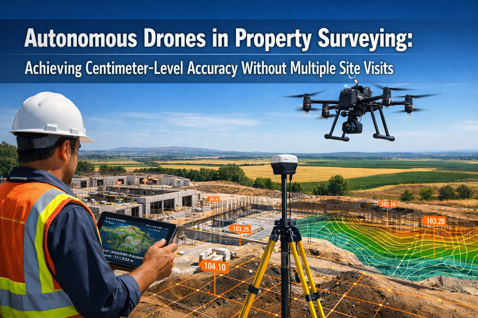
The property surveying industry is experiencing a revolutionary transformation in 2026. Autonomous Drones in Property Surveying: Achieving Centimeter-Level Accuracy Without Multiple Site Visits represents more than just technological advancement—it marks a fundamental shift in how professionals capture, process, and deliver survey-grade data. Gone are the days when surveying teams needed weeks of fieldwork, multiple site visits, and extensive manual measurements to produce accurate property assessments. Today's autonomous drone systems equipped with multi-sensor payloads, AI-driven flight planning, and Real-Time Kinematic (RTK) positioning technology are delivering centimeter-level precision in a fraction of the time, fundamentally changing the economics and efficiency of property surveying across agricultural, development, and commercial sectors.
Key Takeaways
✅ Centimeter-level accuracy is now standard with RTK/PPK GNSS systems, matching or exceeding traditional ground-based surveying methods without requiring multiple site visits[1][2]
✅ Dramatic time reduction from approximately 100 hours to as little as 2 hours for surveying a 12-acre property, with autonomous systems covering hundreds of acres in single missions[6]
✅ Multi-sensor integration enables comprehensive data capture through interchangeable 4K cameras, LiDAR, thermal sensors, and multispectral equipment on a single autonomous platform[4]
✅ AI-powered automation handles flight planning, terrain following, obstacle detection, and real-time data validation, eliminating manual oversight and processing bottlenecks[1][2]
✅ Rapid deliverable turnaround has been reduced from 10 days to three days or less for permit-ready surveys, addressing critical bottlenecks in construction and development workflows[3]
The Evolution of Survey-Grade Accuracy in Autonomous Drone Systems
The journey toward Autonomous Drones in Property Surveying: Achieving Centimeter-Level Accuracy Without Multiple Site Visits has been marked by significant technological breakthroughs in positioning systems, sensor miniaturization, and artificial intelligence integration.
RTK and PPK GNSS: The Foundation of Precision
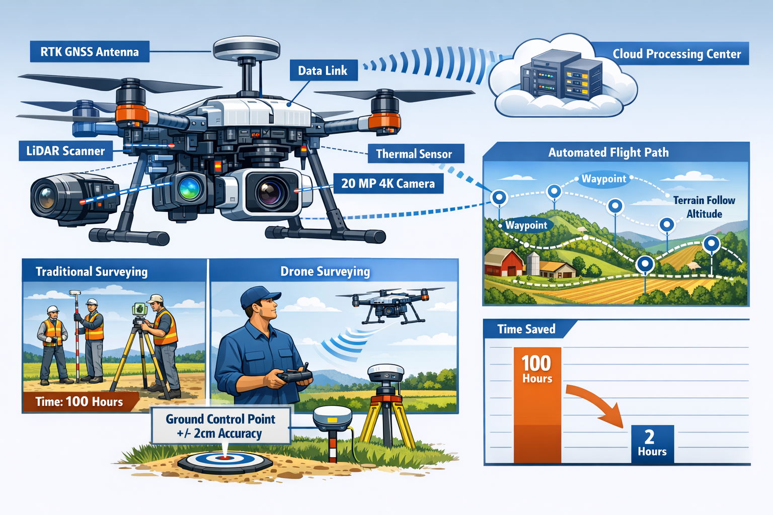
Modern autonomous drones have achieved professional survey-grade standards through Real-Time Kinematic (RTK) and Post-Processed Kinematic (PPK) GNSS systems. These technologies deliver positioning accuracy comparable to or exceeding traditional ground-based methods, typically achieving precision within 1-2 centimeters in both horizontal and vertical dimensions[1][2].
RTK systems receive correction data from base stations in real-time during flight, continuously adjusting the drone's position calculations. PPK systems, alternatively, record raw satellite data during the mission and apply corrections during post-processing. Both approaches dramatically reduce dependency on ground control points (GCPs)—the physical markers traditionally required throughout surveyed areas.
In 2026 workflows, surveyors now rely on significantly fewer ground control points without sacrificing accuracy. This advancement proves particularly impactful for remote locations, linear infrastructure projects like pipelines or transmission corridors, and large-scale agricultural properties where establishing numerous GCPs would be time-prohibitive and costly[1].
Multi-Sensor Payloads: Comprehensive Data Capture
The shift to multi-sensor autonomous platforms represents a paradigm change in property surveying capabilities. Modern systems support interchangeable survey equipment including:
- 4K and higher resolution cameras for detailed orthomosaic generation
- LiDAR scanners for penetrating vegetation and capturing bare-earth terrain models
- Thermal sensors for identifying moisture intrusion, heat loss, and subsidence indicators
- Multispectral sensors for agricultural analysis, vegetation health assessment, and environmental monitoring[4]
This sensor versatility allows a single autonomous platform to serve multiple surveying purposes. A commercial property survey might utilize high-resolution optical cameras and thermal imaging, while agricultural terrain mapping leverages multispectral sensors to assess crop health and soil conditions[5].
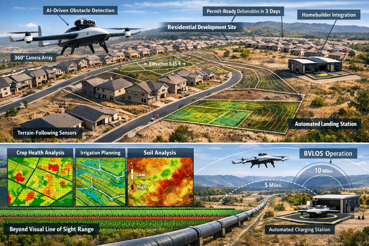
The ZenaTech IQ Quad, launched in January 2026, exemplifies this multi-sensor approach. This autonomous Vertical Take-off and Landing (VTOL) AI drone features 360-degree situational awareness cameras, advanced obstacle detection systems, terrain-following sensors, and autonomous recharging capabilities via dedicated landing stations[4]. Such platforms can operate continuously across large properties without human intervention, automatically swapping batteries or recharging between mission segments.
AI-Driven Flight Planning and Terrain Awareness
Automated onboard AI processing has eliminated much of the manual planning and oversight that previously constrained surveying operations. Modern autonomous drones feature:
- Automated flight planning with terrain awareness that adjusts altitude to maintain consistent ground sampling distance across varying topography
- AI-driven stabilization ensuring consistent image overlap ratios (typically 70-80% forward and side overlap for photogrammetry)
- Real-time data validation that identifies coverage gaps or quality issues during flight, automatically adjusting mission parameters
- Obstacle detection and avoidance using computer vision and sensor fusion to navigate safely around structures, vegetation, and temporary obstructions[1][2]
This intelligence layer transforms drones from remotely piloted aircraft into truly autonomous surveying systems capable of executing complex missions with minimal human intervention. For professionals conducting building surveys or boundary surveys, this means focusing on data interpretation rather than flight operations.
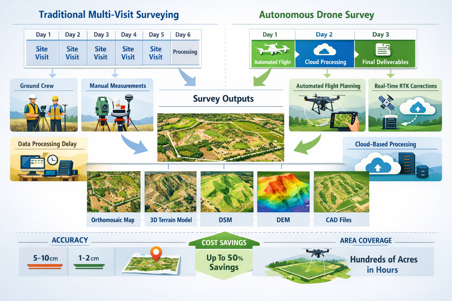
Eliminating Multiple Site Visits: The Single-Mission Surveying Workflow
The traditional surveying workflow required multiple site visits: initial reconnaissance, ground control point establishment, data collection sessions (often interrupted by weather), verification surveys, and final validation. Autonomous Drones in Property Surveying: Achieving Centimeter-Level Accuracy Without Multiple Site Visits condenses this timeline dramatically.
The 2026 Autonomous Survey Workflow
Today's streamlined process typically follows these steps:
1. Pre-Mission Planning (Remote)
Using satellite imagery, existing survey data, and property boundaries, AI systems generate optimized flight plans accounting for terrain variation, required resolution, and regulatory airspace constraints. This planning occurs entirely off-site, eliminating preliminary reconnaissance visits.
2. Single-Visit Data Capture
The autonomous drone deploys to the site, either piloted by an operator or launched from a permanent drone-in-a-box station. The system executes the pre-planned mission with real-time adjustments for wind, lighting conditions, and unexpected obstacles. Multi-sensor payloads capture comprehensive data in a single pass—visual imagery, elevation data, thermal readings, and specialized measurements as required.
For a typical 12-acre property, what once required approximately 100 hours of traditional surveying now takes as little as 2 hours of autonomous drone operation[6]. Larger properties benefit even more dramatically—a single UAV mission can survey hundreds of acres in hours[1][2].
3. Automated Cloud Processing
Captured data automatically uploads to cloud-based processing platforms during or immediately after the flight. Advanced photogrammetry algorithms, often enhanced with machine learning, process thousands of images into cohesive deliverables without manual intervention. This eliminates the weeks of processing time that characterized traditional workflows.
4. Rapid Deliverable Generation
Survey-grade outputs are generated automatically, including:
- High-resolution orthomosaic maps (georeferenced aerial imagery corrected for terrain and camera distortion)
- Accurate 3D terrain models with centimeter-level fidelity
- Digital Surface Models (DSM) showing all features including vegetation and structures
- Digital Elevation Models (DEM) representing bare-earth terrain
- Contour maps with user-specified intervals
- CAD-ready files for direct integration into design software[1][2]
Case Study: Accelerated Permit-Ready Surveys for Homebuilders
ZenaTech's integration of autonomous drone workflows with their Drone as a Service platform demonstrates the real-world impact of eliminating multiple site visits. Following their acquisition of Cardinal Civil Resources—a land surveying firm with established relationships across U.S. homebuilders—ZenaTech reduced survey turnaround time from a typical 10 days to three days or less for permit-ready surveys[3].
This acceleration addresses a critical bottleneck in residential construction. Building permits require accurate site surveys showing existing conditions, proposed grading, drainage patterns, and compliance with setback requirements. Traditional surveying timelines often delayed project starts, increased carrying costs, and complicated construction scheduling.
By deploying autonomous drones equipped with RTK positioning and multi-sensor payloads, ZenaTech's teams capture comprehensive site data in a single visit. AI-assisted processing generates permit-ready deliverables within days, enabling homebuilders to submit applications faster and maintain tighter project schedules. The integration of specialized surveying expertise with autonomous drone technology creates a seamless workflow from data capture through regulatory submission[3].
For professionals managing commercial dilapidation surveys or conducting roof surveys, similar time compression benefits apply. Detailed condition documentation that once required multiple site visits, scaffolding, or lift equipment can now be accomplished through a single autonomous drone mission with appropriate sensors.
Beyond Visual Line of Sight: Regulatory Maturation and Operational Expansion
A critical enabler of Autonomous Drones in Property Surveying: Achieving Centimeter-Level Accuracy Without Multiple Site Visits has been the maturation of regulatory frameworks governing drone operations in 2026.
BVLOS Operations Now Standard
Beyond Visual Line of Sight (BVLOS) operations—where drones fly beyond the operator's direct visual observation—are increasingly approved for commercial surveying applications. This regulatory evolution enables:
- Linear infrastructure surveys along pipelines, transmission corridors, railways, and roadways extending for miles
- Large-scale agricultural mapping across properties spanning thousands of acres
- Remote site monitoring where establishing on-site operator positions would be impractical or unsafe
- Automated routine surveys conducted by drone-in-a-box systems without human presence[1]
Regulatory authorities have established robust frameworks incorporating Remote ID technology, which broadcasts drone identification and location information to airspace management systems. This integration enables safe BVLOS operations while maintaining airspace awareness and security.
Drone-in-a-Box Systems
Autonomous drone-in-a-box systems represent the ultimate expression of single-visit surveying efficiency. These permanently installed stations house autonomous drones that can:
- Self-deploy on scheduled or triggered missions without human operators
- Automatically recharge between flights, enabling continuous operation
- Upload data directly to cloud processing platforms in real-time
- Conduct routine monitoring of development sites, agricultural properties, or infrastructure assets
For large development projects, a single drone-in-a-box installation can provide continuous surveying coverage throughout construction phases, eliminating the need for scheduling survey crews, coordinating site access, or managing multiple contractor visits. The system captures progress documentation, volumetric measurements for earthwork verification, and as-built surveys automatically.
Multi-Sensor Applications: Agricultural and Development Site Case Studies
The versatility of multi-sensor autonomous platforms becomes particularly evident when examining specific applications across different property types in 2026.
Agricultural Terrain Mapping and Precision Agriculture
Large-scale agricultural operations have embraced autonomous drone surveying for applications extending far beyond basic property boundaries. Multispectral sensors mounted on autonomous platforms capture data across specific wavelength bands—including near-infrared, red edge, and visible spectrum—to assess crop health, identify stress areas, and optimize resource application[5].
Case Study: 2,000-Acre Agricultural Property Assessment
A typical large-scale agricultural survey in 2026 might involve:
- Initial comprehensive mapping using high-resolution optical cameras and LiDAR to establish baseline topography, drainage patterns, and field boundaries
- Periodic multispectral surveys throughout growing seasons to monitor crop development, identify irrigation deficiencies, and detect pest or disease pressure
- Thermal imaging to assess soil moisture variation and optimize irrigation scheduling
- Automated volumetric analysis of grain storage facilities, silage piles, and commodity stockpiles
The autonomous drone completes the entire 2,000-acre survey in approximately 4-6 hours of flight time, automatically managing battery swaps or recharging cycles. RTK positioning ensures that multitemporal data sets align precisely, enabling accurate change detection and trend analysis across seasons.
Processing occurs automatically in the cloud, generating:
- NDVI (Normalized Difference Vegetation Index) maps showing crop vigor
- Prescription maps for variable-rate fertilizer or pesticide application
- Drainage analysis identifying areas requiring tile installation or grading modification
- Yield prediction models based on crop health indicators
This comprehensive analysis, delivered within 2-3 days of data capture, enables precision agriculture practices that optimize input costs while maximizing productivity—all from a single autonomous survey mission rather than multiple manual field assessments.
Development Site Surveying and Progress Monitoring
Residential and commercial development projects benefit enormously from the single-visit efficiency and rapid turnaround of autonomous drone surveying.
Case Study: Mixed-Use Development Site (45 Acres)
A typical development site survey workflow in 2026 demonstrates the integration of multiple sensor types and AI-driven processing:
Pre-Construction Phase:
- High-resolution optical survey captures existing conditions with centimeter-level accuracy using RTK-equipped autonomous drone
- LiDAR scanning penetrates vegetation to reveal bare-earth terrain, critical for accurate grading plans
- Thermal imaging identifies subsidence risks, underground moisture, and potential foundation concerns
- Automated deliverable generation produces topographic maps, 3D terrain models, and CAD-ready files for engineering design
The entire pre-construction survey completes in approximately 3 hours of flight time, with permit-ready deliverables available within 3 days[3].
Construction Phase:
- Monthly progress surveys document earthwork volumes, verify grading compliance, and track construction advancement
- Automated volumetric calculations compare actual earthwork against design specifications, identifying over-excavation or under-fill conditions
- As-built documentation captures completed infrastructure for record drawings and warranty documentation
Final Phase:
- Comprehensive final survey verifies compliance with approved plans, documents completed improvements, and provides as-built records for property transfer
- Comparative analysis overlays final conditions against original design, automatically identifying deviations requiring documentation
For professionals conducting property valuations or retrospective valuations, the comprehensive documentation provided by autonomous drone surveys offers unprecedented detail and accuracy for assessment purposes.
Technical Specifications: Understanding Centimeter-Level Accuracy
The claim of centimeter-level accuracy in autonomous drone surveying deserves detailed examination to understand both capabilities and limitations.
Accuracy Components and Specifications
Survey accuracy comprises several distinct measurements:
| Accuracy Type | Typical 2026 Performance | Application |
|---|---|---|
| Horizontal Accuracy (X/Y) | ±1-2 cm with RTK/PPK | Property boundaries, structure positioning |
| Vertical Accuracy (Z) | ±2-3 cm with RTK/PPK | Topography, grading verification, volumetrics |
| Relative Accuracy | ±0.5-1 cm | Feature-to-feature measurements within survey |
| Absolute Accuracy | ±1-3 cm | Georeferenced positioning in coordinate systems |
These specifications assume proper RTK/PPK implementation, appropriate ground control (even if minimal), favorable GNSS satellite geometry, and proper flight planning with adequate image overlap[1][2].
Factors Affecting Accuracy
Several variables influence the actual accuracy achieved:
Environmental Conditions:
- GNSS signal quality affected by tree canopy, tall structures, or atmospheric conditions
- Lighting conditions impacting photogrammetric processing quality
- Wind and atmospheric stability affecting image sharpness and platform stability
Technical Parameters:
- Ground sampling distance (GSD) determined by sensor resolution and flight altitude
- Image overlap ratios (typically 70-80% forward and side overlap for optimal results)
- Camera calibration quality and lens distortion correction
- RTK/PPK base station proximity and correction data quality
Processing Methodology:
- Tie point density and distribution in photogrammetric processing
- Ground control point quantity and distribution (when used)
- Algorithm selection and processing parameter optimization
Modern AI-assisted processing systems automatically optimize many of these parameters, identifying potential accuracy issues and adjusting processing workflows accordingly[1][2].
Validation and Quality Assurance
Professional surveying workflows in 2026 incorporate multiple validation steps:
- Real-time quality checks during flight identify coverage gaps or image quality issues
- Automated processing reports highlight potential accuracy concerns or data anomalies
- Independent check points verify achieved accuracy against known survey monuments
- Comparative analysis against existing survey data validates consistency and reliability
For critical applications requiring regulatory compliance or legal defensibility—such as boundary surveys or surveys supporting party wall matters—professional surveyors supplement autonomous drone data with targeted conventional measurements at key control points.
Cost-Benefit Analysis: Economic Impact of Single-Visit Surveying
The shift to Autonomous Drones in Property Surveying: Achieving Centimeter-Level Accuracy Without Multiple Site Visits delivers substantial economic benefits across multiple dimensions.
Direct Cost Reductions
Labor Efficiency:
Traditional surveying requires multi-person crews spending days or weeks on-site. Autonomous drone operations typically require:
- Single operator for deployment and oversight
- Minimal on-site time (hours rather than days)
- Reduced travel and accommodation costs for remote sites
- Elimination of multiple mobilization/demobilization cycles
Equipment and Overhead:
- Reduced need for extensive ground-based surveying equipment
- Lower insurance costs due to reduced personnel exposure to hazards
- Decreased vehicle and transportation expenses
- Minimal site preparation requirements
Time Value:
The compression from 100 hours to 2 hours for a 12-acre survey[6] translates directly to cost savings and faster project timelines. For development projects where carrying costs accumulate daily, accelerated survey turnaround from 10 days to 3 days[3] significantly impacts project economics.
Expanded Capability Value
Beyond direct cost reduction, autonomous drone surveying enables capabilities impractical with traditional methods:
Frequent Monitoring:
The low marginal cost of additional surveys enables routine monitoring previously considered too expensive. Development sites can implement weekly or monthly progress documentation, agricultural operations can conduct regular crop health assessments, and infrastructure owners can maintain continuous condition monitoring.
Comprehensive Coverage:
Large or difficult-to-access areas become economically feasible to survey. Linear infrastructure extending for miles, remote properties with limited access, or hazardous sites with safety concerns all benefit from autonomous drone capabilities.
Multi-Purpose Data:
A single survey mission captures data serving multiple purposes—topographic mapping, thermal analysis, vegetation assessment, and visual documentation—eliminating the need for separate specialized surveys.
Return on Investment Considerations
Organizations evaluating autonomous drone surveying systems should consider:
Capital Investment:
- High-quality RTK-equipped autonomous drone platforms: £15,000-£50,000
- Multi-sensor payloads (LiDAR, thermal, multispectral): £10,000-£100,000 depending on specifications
- Processing software and cloud platform subscriptions: £2,000-£10,000 annually
- Training and certification: £2,000-£5,000 per operator
Operational Costs:
- Minimal per-mission costs (battery charging, routine maintenance)
- Cloud processing fees (typically per-acre or per-project)
- Insurance and regulatory compliance
- Periodic equipment calibration and certification
For organizations conducting regular surveys—whether commercial property assessments, agricultural monitoring, or development site documentation—the ROI typically materializes within 12-24 months through labor savings, expanded service offerings, and accelerated project timelines.
Integration with Traditional Surveying Practices
While autonomous drones deliver remarkable capabilities, Autonomous Drones in Property Surveying: Achieving Centimeter-Level Accuracy Without Multiple Site Visits represents an evolution of surveying practice rather than complete replacement of traditional methods.
Complementary Technologies
Professional surveyors in 2026 employ autonomous drones as part of an integrated toolkit:
Total Stations and GNSS Receivers:
Ground-based surveying equipment remains essential for:
- Establishing primary control networks
- Surveying beneath dense tree canopy where aerial data proves insufficient
- Precise measurements of specific features requiring sub-centimeter accuracy
- Legal boundary determinations requiring physical monumentation
Terrestrial Laser Scanning:
Ground-based LiDAR complements aerial data for:
- Building facades and architectural details
- Interior spaces and covered areas
- Underside documentation of bridges and structures
- Areas with vertical surfaces poorly captured from aerial perspectives
Conventional Measurements:
Traditional techniques retain importance for:
- Legal boundary surveys requiring physical occupation of corners
- Verification of critical dimensions
- Underground utility locations
- Situations where regulatory requirements mandate specific methodologies
Hybrid Workflows
The most effective surveying workflows in 2026 strategically combine autonomous drone capabilities with targeted conventional measurements:
Efficient Control Networks:
Rather than establishing dense ground control point networks across entire properties, surveyors establish minimal strategic control points. Autonomous drones with RTK/PPK capabilities survey the bulk of the property, while conventional methods verify key positions and supplement areas where aerial data proves insufficient.
Phased Approach:
Large projects often employ autonomous drones for comprehensive initial surveys and routine monitoring, with targeted conventional surveys addressing specific features or verification requirements. This approach maximizes efficiency while maintaining professional standards and regulatory compliance.
Specialized Applications:
Certain surveying specialties benefit particularly from drone integration:
- Roof surveys eliminate safety risks of physical access while providing comprehensive condition documentation
- Subsidence surveys benefit from precise elevation models enabling detailed settlement analysis
- Development site monitoring provides continuous documentation without disrupting construction activities
Future Developments and Emerging Capabilities
The trajectory of autonomous drone surveying technology suggests continued advancement in accuracy, automation, and application diversity.
Enhanced AI and Machine Learning Integration
Future systems will incorporate more sophisticated artificial intelligence:
Automated Feature Extraction:
AI algorithms will automatically identify and classify features—buildings, vegetation, infrastructure, water bodies—directly from raw sensor data, generating intelligent deliverables rather than requiring manual interpretation.
Predictive Analytics:
Machine learning models trained on historical survey data will predict future conditions—erosion patterns, settlement trends, vegetation encroachment—enabling proactive management rather than reactive response.
Intelligent Quality Control:
Advanced AI will identify data quality issues, processing anomalies, and potential accuracy concerns automatically, ensuring consistent deliverable quality without extensive manual review.
Expanded Sensor Capabilities
Emerging sensor technologies will broaden surveying applications:
Hyperspectral Imaging:
Advanced sensors capturing dozens or hundreds of spectral bands will enable detailed material identification, environmental assessment, and specialized analysis beyond current multispectral capabilities.
Ground-Penetrating Radar:
Airborne GPR systems will reveal subsurface features—buried utilities, archaeological remains, soil composition—without excavation or ground-based scanning.
Advanced LiDAR:
Higher-resolution, longer-range LiDAR systems with improved vegetation penetration will capture even more detailed terrain models and enable new applications in forestry and environmental monitoring.
Regulatory Evolution
Continued regulatory development will enable expanded operational capabilities:
Urban BVLOS Operations:
As detect-and-avoid technologies mature and regulatory frameworks evolve, BVLOS operations will extend into urban environments, enabling efficient surveying of developed areas without line-of-sight limitations.
Automated Approvals:
Digital airspace management systems will provide near-instantaneous flight approvals for routine surveying operations, eliminating administrative delays and enabling responsive surveying services.
International Harmonization:
Increasing standardization of drone regulations across jurisdictions will simplify operations for organizations conducting surveys across multiple regions or countries.
Implementing Autonomous Drone Surveying: Practical Considerations
Organizations seeking to adopt Autonomous Drones in Property Surveying: Achieving Centimeter-Level Accuracy Without Multiple Site Visits should consider several practical implementation factors.
Technology Selection
Platform Capabilities:
- Flight time and range appropriate for typical project sizes
- Payload capacity supporting required sensor combinations
- RTK/PPK compatibility for centimeter-level accuracy requirements
- Autonomous features including obstacle avoidance, terrain following, and automated mission execution
- Weather resistance enabling operation in varied conditions
Sensor Selection:
- Optical cameras with resolution appropriate for required ground sampling distance
- LiDAR systems if vegetation penetration or high-density point clouds are needed
- Thermal sensors for building surveys, moisture detection, or agricultural applications
- Multispectral sensors for agricultural or environmental monitoring
Processing Infrastructure:
- Cloud-based platforms offering automated processing and deliverable generation
- Software compatibility with existing CAD, GIS, and design systems
- Storage and data management capabilities for large datasets
- Collaborative tools enabling client access and review
Training and Certification
Effective implementation requires appropriate expertise:
Operator Training:
- Regulatory compliance and airspace knowledge
- Platform-specific operation and emergency procedures
- Mission planning and flight parameter optimization
- Data quality assessment and validation
Processing Expertise:
- Photogrammetry principles and processing workflows
- Quality control procedures and accuracy verification
- Deliverable generation and format conversion
- Client communication and expectation management
Professional Development:
Surveying professionals should maintain traditional surveying competencies while developing drone-specific expertise, ensuring ability to validate autonomous survey results and integrate them appropriately within professional practice standards.
Quality Management Systems
Professional organizations should establish robust quality management:
Standard Operating Procedures:
- Mission planning protocols ensuring appropriate parameters
- Pre-flight checklists and equipment verification
- Data collection standards and quality metrics
- Processing workflows and validation requirements
Documentation Standards:
- Metadata capture for all surveys (date, conditions, equipment, settings)
- Processing reports documenting methods and parameters
- Accuracy verification and check point analysis
- Deliverable specifications and format standards
Continuous Improvement:
- Regular equipment calibration and verification
- Performance metrics tracking (accuracy, efficiency, client satisfaction)
- Technology evaluation and upgrade planning
- Staff training and competency development
Conclusion: The New Standard in Property Surveying
Autonomous Drones in Property Surveying: Achieving Centimeter-Level Accuracy Without Multiple Site Visits has transitioned from emerging technology to established professional practice in 2026. The convergence of RTK/PPK positioning systems, multi-sensor platforms, AI-driven automation, and mature regulatory frameworks has created surveying capabilities that fundamentally transform project economics, timelines, and scope.
The evidence is compelling: 100-hour surveys completed in 2 hours[6], permit-ready deliverables in 3 days instead of 10[3], and hundreds of acres surveyed in single missions[1][2]. These improvements represent not incremental progress but order-of-magnitude advances in surveying efficiency and capability.
For agricultural operations, autonomous drone surveying enables precision agriculture practices previously impractical at scale. For development projects, rapid turnaround and continuous monitoring capabilities accelerate timelines and improve project management. For infrastructure owners, routine automated surveys provide unprecedented visibility into asset conditions and maintenance requirements.
The technology continues advancing—enhanced AI capabilities, expanded sensor options, and evolving regulatory frameworks promise even greater capabilities in coming years. Organizations that embrace autonomous drone surveying position themselves at the forefront of their industries, delivering superior service while operating more efficiently.
Actionable Next Steps
For Surveying Professionals:
- Evaluate current project mix to identify applications where autonomous drone surveying delivers maximum value
- Assess technology options considering platform capabilities, sensor requirements, and processing infrastructure
- Develop implementation plan including equipment acquisition, training programs, and quality management systems
- Start with pilot projects to develop expertise and refine workflows before full-scale deployment
- Maintain professional standards by integrating drone capabilities appropriately within established surveying practices
For Property Owners and Developers:
- Engage with surveying firms offering autonomous drone capabilities for upcoming projects
- Request demonstrations of deliverable quality and turnaround times for projects similar to yours
- Consider routine monitoring programs leveraging low marginal costs of additional surveys
- Explore expanded applications beyond traditional surveying—thermal analysis, vegetation monitoring, progress documentation
- Verify professional qualifications ensuring providers maintain appropriate certifications and professional standards
For Agricultural Operations:
- Investigate precision agriculture applications enabled by multispectral and thermal drone surveys
- Establish baseline property documentation through comprehensive initial surveys
- Implement periodic monitoring to track crop development, identify issues early, and optimize inputs
- Integrate survey data with farm management systems and precision application equipment
- Evaluate ROI based on input optimization, yield improvement, and operational efficiency
The transformation of property surveying through autonomous drone technology represents one of the most significant advances in the profession's history. Organizations and professionals who understand and leverage these capabilities position themselves for success in an increasingly competitive and efficiency-driven marketplace. The question is no longer whether to adopt autonomous drone surveying, but how quickly and effectively to integrate these powerful capabilities into professional practice.
For those seeking professional surveying services incorporating the latest autonomous drone technology, chartered surveyors in London and surrounding regions now offer comprehensive solutions combining traditional expertise with cutting-edge autonomous capabilities—delivering the centimeter-level accuracy, rapid turnaround, and comprehensive documentation that modern property projects demand.
References
[1] How Drones Are Transforming Surveying Mapping And Inspection In 2026 – https://www.uavsphere.com/post/how-drones-are-transforming-surveying-mapping-and-inspection-in-2026
[2] Self Flying Uavs For Survey Mapping Are Redefining Aerial Intelligence – https://www.dronitech.com/self-flying-uavs-for-survey-mapping-are-redefining-aerial-intelligence/
[3] Zenatech S Drone As A Service Expands Builder Services Capability Delivering Drone Driven Speed And Precision To Surveying For Homebuilders – https://markets.businessinsider.com/news/currencies/zenatech-s-drone-as-a-service-expands-builder-services-capability-delivering-drone-driven-speed-and-precision-to-surveying-for-homebuilders-1035808701
[4] Autonomous Vtol Ai Drone Launched For Surveying Mapping Applications – https://www.unmannedsystemstechnology.com/2026/01/autonomous-vtol-ai-drone-launched-for-surveying-mapping-applications/
[5] Automated Multispectral Terrain Mapping Using Drones And Robotics – https://www.roboticstomorrow.com/article/2026/01/automated-multispectral-terrain-mapping-using-drones-and-robotics/26021
[6] Drones In Construction – https://uavcoach.com/drones-in-construction/