When planning a property purchase, construction project, or boundary dispute resolution, understanding land survey costs can mean the difference between staying on budget and facing unexpected financial surprises. In 2026, Land Survey Costs in 2026: Complete Guide to Pricing Trends and Budgeting Strategies has become essential knowledge for property owners, developers, and real estate professionals navigating an increasingly complex pricing landscape shaped by inflation, technological innovation, and regional market variations.
The land surveying industry has experienced significant transformation over the past two years. While inflation has pushed baseline costs upward by approximately 8-12%, technological advances like drone surveying and GPS precision tools have simultaneously created efficiency gains that partially offset these increases[1]. This dynamic creates a nuanced pricing environment where savvy property owners can find substantial savings through strategic planning and informed decision-making.
Key Takeaways
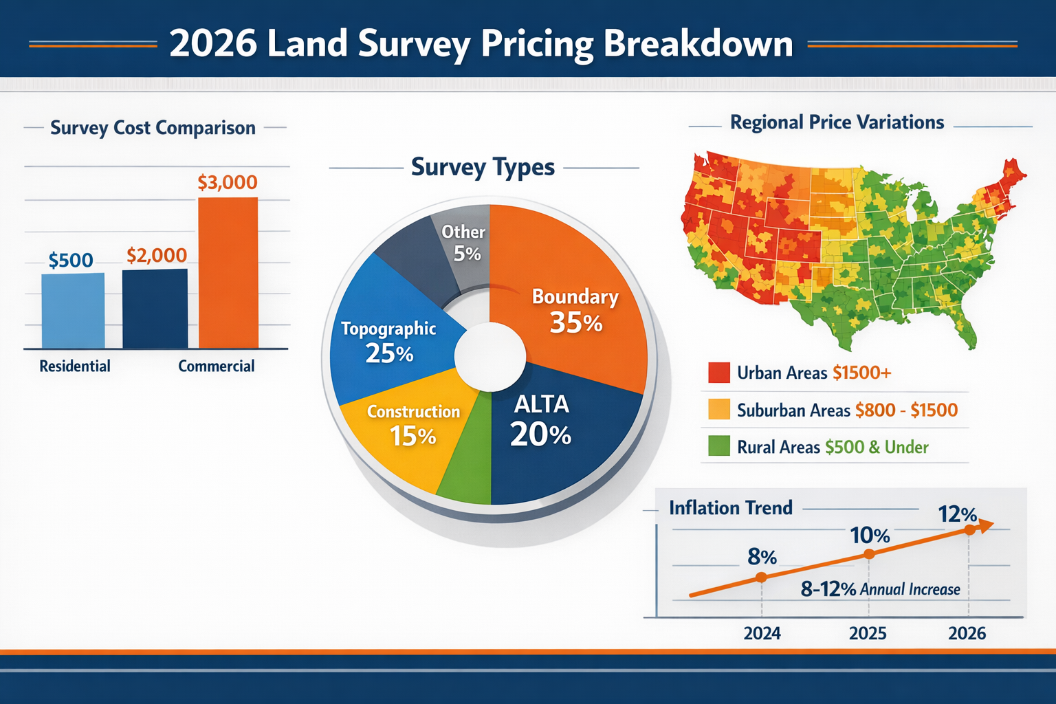
📊 Average costs: Land surveys in 2026 average $2,300 nationally, with typical ranges from $475 to $25,000 depending on survey complexity, property size, and location[3][4].
🏘️ Regional variation matters: Urban areas like New York and San Francisco charge upwards of $1,500 for basic residential surveys, while rural regions offer similar services for $500 or less[1].
💰 Commercial premium: Commercial land surveys cost significantly more than residential surveys, averaging $1,000–$5,000 due to increased complexity and regulatory requirements[1].
🚁 Technology reduces costs: Modern surveying technologies including drones and advanced GPS systems have created 15-25% efficiency improvements that help offset inflation-driven price increases[1].
📈 Strategic timing saves money: Off-season scheduling, obtaining multiple quotes, and proper property preparation can reduce total survey costs by 20-30%.
Understanding the 2026 Land Survey Market Landscape
The land surveying market in 2026 operates within a unique economic environment characterized by competing pressures. On one hand, persistent inflation, increased labor costs, and rising equipment expenses have pushed baseline prices upward. On the other hand, technological innovation and increased competition have created downward pressure on pricing for certain survey types.
Inflation Impact on Survey Pricing
Between 2024 and 2026, the land surveying industry experienced cost increases across multiple operational categories. Labor costs have risen approximately 10-12% as surveying professionals command higher wages in a competitive employment market[1]. Equipment costs, particularly for traditional surveying instruments, have increased by 8-10% due to supply chain challenges and manufacturing cost pressures.
These inflationary pressures directly translate to consumer pricing. A basic boundary survey that cost $900 in 2024 now averages $1,000-$1,100 in 2026, representing an 11-22% increase depending on regional factors[1]. However, this increase remains moderate compared to other construction-related services, partly due to technological efficiencies.
Construction Boom Influence
The ongoing construction boom across many metropolitan areas has created sustained demand for land surveying services. This heightened demand has particularly impacted pricing in rapidly developing regions where surveyor availability remains constrained. In high-growth markets like Austin, Phoenix, and parts of the Southeast, survey costs have increased 15-20% above the national average due to capacity constraints[1].
Conversely, this demand has attracted new entrants to the surveying profession and encouraged existing firms to expand capacity, which may moderate price increases in 2027 and beyond.
Technology as a Cost Offset
Perhaps the most significant development in the Land Survey Costs in 2026: Complete Guide to Pricing Trends and Budgeting Strategies narrative is the widespread adoption of cost-reducing technologies. Drone surveying has revolutionized topographic and large-property surveys, reducing field time by 40-60% for certain applications[1]. GPS-based systems have similarly accelerated boundary identification and measurement processes.
These technological advances create a bifurcated market: surveying firms that have invested in modern equipment can offer competitive pricing while maintaining healthy margins, whereas traditional firms relying exclusively on conventional methods face pressure to reduce prices or risk losing market share.
Comprehensive Breakdown of Land Survey Costs in 2026
Understanding the specific cost ranges for different survey types represents a critical component of effective budgeting. The following sections provide detailed pricing information based on current 2026 market data.
National Average Costs and Ranges
According to current market analysis, land surveys average $2,300 nationally in 2026, though this figure masks substantial variation[3][4]. The complete range extends from $475 for simple residential boundary surveys to $25,000 or more for complex ALTA surveys on large commercial properties[3][4].
For typical homeowner applications, the practical range falls between $800 and $5,500, with most residential surveys clustering around $1,200-$1,500[4]. This represents the sweet spot where property size, survey complexity, and regional pricing converge for standard suburban residential lots.
Survey Type-Specific Pricing
Different survey types serve distinct purposes and command varying price points based on complexity, time requirements, and deliverable specifications.
Boundary Surveys
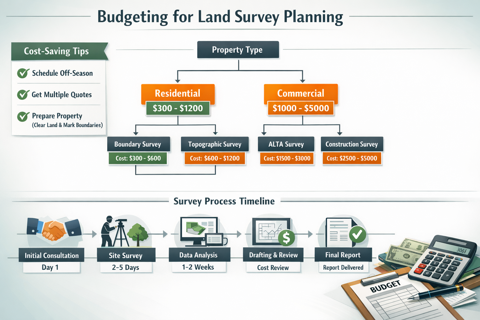
Boundary surveys remain the most commonly requested survey type for residential property owners. These surveys establish precise property lines, identify encroachments, and provide legal documentation of property boundaries. In 2026, boundary surveys range from $1,200 to $5,500 depending on property size, terrain complexity, and research requirements[3].
For a standard suburban residential lot (quarter-acre or less), expect to pay $1,200-$2,000. Larger properties, rural parcels with unclear historical boundaries, or properties requiring extensive deed research can easily exceed $3,000-$5,500[3].
Topographic Surveys
Topographic surveys map elevation changes, natural features, and existing structures, making them essential for construction planning and site development. Residential topographic surveys typically cost $500-$2,500, while comprehensive topographic surveys for commercial or development projects range from $2,000 to $6,500[3].
The wide price variation reflects differences in property size, terrain complexity, and the level of detail required. A simple residential topo survey for a home addition might cost $600-$800, while a detailed survey for a commercial development covering multiple acres could reach $5,000-$6,500[3].
ALTA/NSPS Land Title Surveys
ALTA surveys (American Land Title Association surveys) represent the most comprehensive and expensive survey type, typically required for commercial real estate transactions. These surveys meet stringent national standards and include extensive detail about property boundaries, improvements, easements, and potential encumbrances.
In 2026, ALTA surveys range from $2,500 to $10,000 or more, with most commercial transactions requiring $4,000-$7,000 for standard properties[3]. Large or complex commercial sites can exceed $15,000 when extensive research and detailed mapping are required.
Construction Surveys
Construction surveys guide building placement, ensure compliance with setback requirements, and verify that structures are built according to approved plans. These surveys typically cost $1,000-$5,000 depending on project scope and the number of site visits required[3].
Simple residential construction surveys (often called "stake-out" surveys) start around $1,000-$1,500, while complex commercial construction requiring multiple verification visits throughout the building process can reach $4,000-$5,000 or more[3].
Property Size Impact on Survey Costs
Property acreage significantly influences survey costs due to increased field time, measurement requirements, and complexity. The following table illustrates typical cost ranges by property size:
| Property Size | Typical Cost Range | Average Cost |
|---|---|---|
| Less than ¼ acre | $400 – $1,200 | $800 |
| ¼ to ½ acre | $800 – $1,800 | $1,200 |
| ½ to 1 acre | $1,500 – $3,500 | $2,200 |
| 1 to 2 acres | $2,000 – $4,500 | $3,000 |
| 2 to 5 acres | $3,000 – $6,000 | $4,200 |
| 5 to 10 acres | $4,500 – $8,500 | $6,000 |
| 10+ acres | $6,000 – $15,000+ | $9,500+ |
These ranges assume relatively clear property lines and moderate terrain complexity. Properties with dense vegetation, steep terrain, or unclear historical boundaries can add 20-50% to base costs[3].
Labor and Hourly Rate Structures
Many surveying firms structure pricing around hourly labor rates, particularly for complex or unusual projects. In 2026, surveyors charge $220-$450 per hour depending on crew size, equipment requirements, and regional market conditions[3].
Property records research, a critical component of most surveys, typically bills at $85-$160 per hour[3]. This research involves examining historical deeds, plat maps, and previous surveys to establish accurate boundary information. For properties with complex ownership histories or unclear boundaries, research time can add $300-$800 to total survey costs.
Regional Price Variations Across the Land Survey Market
Geographic location represents one of the most significant factors influencing survey costs in 2026. Regional variations stem from differences in labor costs, market competition, regulatory requirements, and local demand pressures.
Urban vs. Rural Pricing Dynamics
Urban areas consistently command premium pricing for land surveying services. In major metropolitan markets like New York, San Francisco, Los Angeles, and Boston, basic residential boundary surveys start at $1,500 and frequently exceed $2,500[1]. These elevated costs reflect higher labor expenses, increased operational overhead, and strong demand in competitive real estate markets.
Conversely, rural regions offer significantly lower pricing, with basic surveys available for $500 or less in many agricultural areas and small towns[1]. This pricing differential creates opportunities for property owners in rural markets while presenting challenges for urban buyers and developers.
High-Cost Metropolitan Markets
Several metropolitan areas stand out for particularly elevated survey costs in 2026:
New York Metropolitan Area: Basic residential surveys range from $1,800-$3,500, with complex surveys or properties in dense urban environments reaching $5,000-$8,000[1]. The combination of high labor costs, challenging site access, and complex property histories drives these premium prices.
San Francisco Bay Area: Similar to New York, the Bay Area commands $1,600-$3,200 for standard residential surveys, with hillside properties or parcels requiring extensive research exceeding $4,000[1].
Los Angeles: Survey costs in LA range from $1,400-$2,800 for typical residential properties, with variation based on specific location within the sprawling metropolitan area[1].
Boston: The Boston market sees residential survey costs of $1,500-$2,900, with historical properties in older neighborhoods often requiring additional research that increases total costs[1].
Moderate-Cost Regional Markets
Mid-sized metropolitan areas and suburban regions typically offer more moderate pricing:
Southeast Markets (Atlanta, Charlotte, Raleigh): $900-$1,800 for standard residential surveys[1]
Midwest Markets (Chicago suburbs, Indianapolis, Columbus): $800-$1,600 for typical residential properties[1]
Southwest Growth Markets (Phoenix, Austin, Denver): $1,000-$2,200, with recent demand pressures pushing costs toward the higher end[1]
Budget-Friendly Rural and Small-Town Markets
Property owners in rural areas and small towns benefit from the most competitive survey pricing:
Agricultural Regions: $500-$1,200 for standard residential or small agricultural parcels[1]
Small Towns (population under 25,000): $600-$1,300 for typical residential surveys[1]
Remote Rural Areas: $700-$1,500, with the higher end reflecting travel time for surveyors serving dispersed populations[1]
For those working with chartered surveyors in Surrey or neighboring regions, understanding these regional variations helps set realistic budget expectations.
Residential vs. Commercial Survey Cost Comparison
The distinction between residential and commercial surveying represents a critical pricing consideration, with commercial surveys commanding substantial premiums due to increased complexity, regulatory requirements, and liability considerations.
Residential Survey Economics
Residential land surveys serve homeowners, prospective buyers, and residential developers. These surveys typically cost $300-$1,200 for straightforward properties, with the national average settling around $800-$1,000 for standard suburban lots[1].
Common residential survey scenarios include:
✅ Pre-purchase boundary verification: $800-$1,500
✅ Fence installation planning: $600-$1,200
✅ Home addition or renovation: $900-$1,800
✅ Boundary dispute resolution: $1,200-$2,500
✅ Subdivision of existing lot: $1,500-$3,500
Residential surveys generally involve simpler legal requirements, smaller property areas, and less demanding accuracy standards compared to commercial work. This allows surveyors to complete projects more efficiently, translating to lower costs for property owners.
When dealing with boundary disputes, accurate surveys become essential for resolution, making the investment worthwhile despite the cost.
Commercial Survey Premium Pricing
Commercial land surveys serve business property owners, developers, and commercial real estate investors. These surveys average $1,000-$5,000, representing a 3-5x premium over comparable residential work[1].
Several factors drive commercial survey costs higher:
🏢 Increased complexity: Commercial properties often involve multiple structures, complex easements, and detailed improvement documentation.
📋 Stringent requirements: Commercial transactions typically require ALTA surveys meeting national standards with comprehensive detail.
⚖️ Higher liability: Surveyors assume greater professional liability for commercial work, requiring additional insurance and quality control measures.
📏 Greater precision: Commercial surveys demand tighter accuracy tolerances to support construction and development activities.
🔍 Extensive research: Commercial properties often have complex ownership histories requiring detailed title research.
Typical commercial survey costs by property type:
Small retail or office: $2,000-$4,000
Industrial warehouse: $3,500-$6,500
Multi-unit residential development: $4,000-$8,000
Large commercial complex: $6,000-$15,000+
Industrial site or campus: $10,000-$25,000+
For businesses requiring commercial building surveys in London, understanding these cost structures helps with project budgeting and financial planning.
Technology-Driven Changes in Survey Pricing and Efficiency

The integration of advanced technology into land surveying represents the most transformative trend affecting Land Survey Costs in 2026: Complete Guide to Pricing Trends and Budgeting Strategies. While technology requires substantial upfront investment, it creates efficiency gains that benefit both surveyors and clients.
Drone Surveying Revolution
Drone technology has fundamentally altered topographic surveying and large-property mapping. Modern survey drones equipped with high-resolution cameras and LiDAR sensors can map large properties in hours rather than days, reducing field time by 40-60% for applicable projects[1].
This efficiency translates to cost savings for clients. A five-acre topographic survey that might have cost $4,500-$6,000 using traditional methods now typically runs $3,000-$4,500 when completed with drone technology[1]. The savings increase proportionally with property size, making drone surveys particularly cost-effective for large parcels.
However, drone surveying has limitations. Dense tree canopy can prevent accurate ground measurement, and regulatory restrictions limit drone operations in certain urban areas and near airports. Additionally, boundary surveys still require traditional ground-based measurements for legal accuracy.
Property owners interested in modern surveying techniques might also explore drone roof surveys for related property assessment needs.
GPS and Robotic Total Stations
GPS-based surveying systems have dramatically improved efficiency for boundary location and measurement. Modern GPS receivers achieve centimeter-level accuracy, allowing surveyors to establish property corners and boundaries much faster than traditional methods.
Robotic total stations enable single-operator surveying, reducing crew size requirements and associated labor costs. A task requiring a two-person crew for a full day using traditional equipment might now be completed by one surveyor in half a day, reducing costs by 30-40%[1].
These efficiency gains haven't universally translated to lower consumer prices due to the high cost of equipment and ongoing inflation. However, they have prevented costs from rising as sharply as they otherwise would have, effectively offsetting 15-25% of inflation-driven price increases[1].
3D Scanning and Digital Modeling
3D laser scanning technology creates highly detailed digital models of properties and structures. While primarily used for complex commercial projects, this technology is increasingly available for high-end residential applications.
3D scanning adds $500-$2,000 to survey costs but provides unprecedented detail and accuracy. For renovation projects, litigation support, or historic preservation, this investment often proves worthwhile by preventing costly errors and disputes.
Software and Data Management
Advanced survey processing software and cloud-based data management systems have improved deliverable quality while reducing processing time. Clients now routinely receive digital survey files, interactive maps, and detailed reports that would have required days of manual drafting just five years ago.
These improvements enhance value without necessarily reducing costs, as surveyors invest in ongoing software subscriptions and training to maintain technological competence.
Strategic Budgeting for Land Survey Costs in 2026
Effective budgeting for land surveys requires understanding cost drivers, identifying potential savings opportunities, and planning strategically around project timelines and requirements.
Cost-Saving Strategies
Property owners can employ several proven strategies to reduce survey costs without compromising quality:
1. Obtain Multiple Quotes (Potential Savings: 15-25%)
Request quotes from 3-5 surveying firms to establish competitive pricing. Ensure quotes cover identical scope to enable accurate comparison. Price variation among qualified surveyors can reach 20-30% in competitive markets, making comparison shopping worthwhile[1].
2. Schedule During Off-Peak Seasons (Potential Savings: 10-20%)
Surveying demand peaks during spring and summer construction seasons. Scheduling surveys during fall or winter can yield discounts of 10-20% as firms seek to maintain steady workflow during slower periods[1].
3. Prepare Property for Survey (Potential Savings: 10-15%)
Clear vegetation along property lines, locate and mark known property corners, and provide surveyors with any existing documentation. This preparation can reduce field time by several hours, translating to $200-$500 in savings[1].
4. Bundle Multiple Services (Potential Savings: 15-25%)
If you require multiple survey types (boundary plus topographic, for example), bundling services with a single surveyor often yields package pricing 15-25% below separate project costs[1].
5. Verify Existing Survey Viability (Potential Savings: 100%)
If a recent survey exists (typically within 5-10 years), it may be possible to have it recertified or updated for $200-$500 rather than commissioning an entirely new survey costing $1,000-$2,000[1].
Budget Planning by Project Type
Different project types require different survey budgets:
Home Purchase: Budget $800-$1,500 for boundary verification
Fence Installation: Budget $600-$1,200 for boundary survey
Home Addition/Renovation: Budget $1,000-$2,000 for boundary and improvement survey
New Construction: Budget $1,500-$3,500 for comprehensive survey and staking
Property Dispute: Budget $1,500-$3,000 for detailed boundary survey with legal documentation
Lot Subdivision: Budget $2,500-$5,000 for subdivision survey and platting
Commercial Purchase: Budget $3,000-$8,000 for ALTA survey
Hidden Costs to Consider
Beyond the base survey fee, several potential additional costs deserve consideration:
💵 Monument installation: $75-$150 per monument if property corners require physical markers[3]
💵 Expedited service: 20-50% premium for rush completion[1]
💵 Travel fees: $50-$200 for properties in remote locations[1]
💵 Additional research: $200-$800 for properties with complex ownership histories[3]
💵 Revision fees: $150-$400 for survey updates or corrections[1]
💵 Additional copies: $25-$75 per additional certified copy[1]
Financing Options
For property owners facing budget constraints, several financing approaches can make survey costs more manageable:
Seller concessions: Negotiate for sellers to cover survey costs as part of purchase agreements
Closing cost inclusion: Roll survey fees into mortgage closing costs
Home equity financing: Use home equity lines for survey costs related to improvements
Payment plans: Some surveying firms offer payment plans for larger commercial projects
Project bundling: Combine survey costs with construction financing for development projects
Those planning significant property improvements might also consider structural surveys as part of comprehensive project planning.
Selecting the Right Survey Type for Your Needs
Choosing the appropriate survey type represents a critical decision affecting both cost and project success. Over-surveying wastes money on unnecessary detail, while under-surveying creates risks of inadequate information.
Decision Framework
Use this decision framework to identify the appropriate survey type:
Question 1: What is the primary purpose?
- Property purchase → Boundary survey
- Construction planning → Topographic survey
- Commercial transaction → ALTA survey
- Fence/wall installation → Boundary survey
- Building permit → Construction survey
- Dispute resolution → Boundary survey with legal description
Question 2: What level of detail is required?
- Basic property lines → Standard boundary survey
- Elevation and features → Topographic survey
- Comprehensive commercial documentation → ALTA survey
- Construction guidance → Construction survey with staking
Question 3: What are the regulatory requirements?
- Lender requirements → Often specify ALTA for commercial, boundary for residential
- Municipality requirements → May require specific survey types for permits
- Title company requirements → Often dictate survey standards for closings
Survey Type Comparison Table
| Survey Type | Best For | Typical Cost | Timeline | Detail Level |
|---|---|---|---|---|
| Boundary | Property lines, fences, disputes | $1,200-$5,500 | 1-2 weeks | Moderate |
| Topographic | Construction planning, grading | $500-$6,500 | 1-3 weeks | High |
| ALTA | Commercial transactions | $2,500-$10,000 | 2-4 weeks | Very High |
| Construction | Building placement, staking | $1,000-$5,000 | 1-2 weeks | Moderate |
| Subdivision | Lot division, platting | $2,500-$8,000 | 3-6 weeks | High |
| As-Built | Post-construction verification | $1,500-$4,000 | 1-2 weeks | High |
Avoiding Over-Surveying and Under-Surveying
Over-surveying occurs when property owners commission more comprehensive surveys than their situation requires. For example, obtaining an ALTA survey for a simple residential fence installation wastes $1,500-$3,000 compared to a basic boundary survey that would serve the purpose adequately.
Under-surveying creates the opposite problem—insufficient information leading to project delays, disputes, or construction errors. A homeowner who skips a topographic survey before planning a major addition might discover drainage issues or grading challenges mid-construction, resulting in expensive redesigns.
The key is matching survey scope precisely to project requirements. Consulting with both surveyors and other professionals (architects, builders, real estate attorneys) helps identify the appropriate survey type.
For specialized needs like subsidence investigations, targeted surveys provide focused information without unnecessary expense.
Working with Professional Surveyors: Maximizing Value
The relationship between property owners and surveyors significantly influences both cost and outcome quality. Understanding how to select, communicate with, and manage surveyor relationships optimizes results.
Surveyor Selection Criteria
When evaluating surveying firms, consider these critical factors:
Professional Credentials ⭐
Verify that surveyors hold appropriate state licensure and professional certifications. Licensed Professional Land Surveyors (PLS or RLS depending on state) have met rigorous education, experience, and examination requirements. Membership in professional organizations like the National Society of Professional Surveyors (NSPS) indicates commitment to ongoing professional development.
Experience and Specialization ⭐
Prioritize surveyors with specific experience in your property type and survey purpose. A surveyor specializing in large commercial ALTA surveys may not be the best choice for a simple residential boundary survey, and vice versa. Ask about similar projects completed in the past year.
Technology and Equipment ⭐
Inquire about the technology and equipment the surveyor uses. Firms employing modern GPS systems, robotic total stations, and drone technology typically complete work more efficiently and accurately than those relying exclusively on traditional methods.
Insurance Coverage ⭐
Verify that surveyors carry adequate professional liability insurance (errors and omissions coverage). This protects property owners if survey errors cause financial damages. Reputable surveyors readily provide proof of insurance upon request.
References and Reviews ⭐
Request references from recent clients with similar projects. Online reviews provide additional perspective, though consider the full pattern rather than individual outlier experiences.
Clear Communication ⭐
Evaluate communication quality during initial consultations. Surveyors should explain their process clearly, provide detailed written proposals, and respond promptly to questions. Poor communication during the sales process typically predicts poor communication during project execution.
For those in specific regions, working with established chartered surveyors in Essex or chartered surveyors in Buckinghamshire ensures local expertise and knowledge.
Questions to Ask Before Hiring
Use these questions to evaluate potential surveyors:
- Are you licensed in this state, and what is your license number?
- How many similar projects have you completed in the past year?
- What technology and equipment will you use for this survey?
- What is your estimated timeline for completion?
- What deliverables are included in your quoted price?
- What factors might cause the final cost to exceed the estimate?
- Do you carry professional liability insurance, and what are the coverage limits?
- Will you personally conduct the survey, or will it be delegated to other staff?
- What happens if errors are discovered after survey completion?
- Can you provide references from recent clients?
Understanding Survey Deliverables
Professional surveys typically include several key deliverables:
📄 Survey plat or map: Scaled drawing showing property boundaries, improvements, and relevant features
📄 Legal description: Written description of property boundaries using metes and bounds or other legal description methods
📄 Surveyor's certificate: Professional certification of survey accuracy and compliance with standards
📄 Digital files: CAD files, PDFs, or other digital formats for use by architects, builders, or other professionals
📄 Field notes: Documentation of measurements and observations (sometimes provided upon request)
📄 Research documentation: Copies of deeds, plat maps, and other records researched during the survey process
Clarify exactly what deliverables are included in the quoted price to avoid surprises. Some surveyors charge additional fees for multiple copies, digital files, or rush delivery.
Red Flags to Avoid
Certain warning signs indicate surveyors to avoid:
🚩 Unwillingness to provide proof of licensure or insurance
🚩 Quotes significantly below market rates (often indicates inexperience or cutting corners)
🚩 Pressure to commit immediately without time for comparison
🚩 Vague or incomplete written proposals
🚩 Poor communication or unresponsiveness
🚩 Unwillingness to provide references
🚩 Guarantees of extremely fast completion (quality surveys require adequate time)
🚩 Cash-only payment requirements (suggests potential tax avoidance or lack of professional structure)
Future Outlook: Survey Cost Trends Beyond 2026
Understanding likely future trends helps property owners and professionals plan for long-term surveying needs and budget accordingly.
Projected Cost Trajectories
Industry analysis suggests moderate continued cost increases through 2027-2028, though at rates below the 2024-2026 period. Projected annual increases of 3-5% align with general inflation expectations, representing a return to more normal pricing patterns after the elevated inflation of recent years[7].
Several factors support this moderate outlook:
Stabilizing inflation: As general economic inflation moderates, surveying cost pressures should likewise ease
Technology maturation: Widespread adoption of efficiency-enhancing technology should continue offsetting labor cost increases
Increased competition: New entrants attracted by strong demand should create competitive pressure on pricing
Improved supply chains: Resolution of equipment and supply chain challenges should moderate equipment cost increases
However, certain scenarios could drive costs higher:
Regulatory expansion: New regulatory requirements or heightened standards could increase compliance costs
Labor shortages: Persistent difficulty attracting new surveyors could drive labor costs higher
Technology costs: Increasing software subscription fees and equipment replacement costs could pressure pricing
Demand surges: Continued construction booms in high-growth regions could sustain elevated pricing
Technology Evolution Impact
Emerging technologies will continue reshaping the surveying landscape:
Artificial intelligence and machine learning will increasingly automate data processing and analysis, potentially reducing processing time by 30-50% for certain survey types by 2028[7].
Advanced drone capabilities including improved sensors, longer flight times, and better obstacle avoidance will expand drone surveying applications to more property types and conditions.
Mobile LiDAR systems will become more affordable and accessible, enabling rapid high-accuracy scanning of large properties at costs approaching traditional surveying methods.
Augmented reality tools will help property owners visualize survey results and understand boundary locations more intuitively, adding value without necessarily increasing costs.
Blockchain-based property records may eventually streamline title research and boundary verification, potentially reducing research time and associated costs.
These technological advances will likely create a bifurcated market: technologically advanced firms offering competitive pricing and enhanced services, while traditional firms face pressure to either modernize or compete primarily on price.
Market Consolidation Trends
The land surveying industry is experiencing gradual consolidation as larger regional and national firms acquire smaller local practices. This trend may influence pricing in several ways:
Potential cost reductions through economies of scale and shared technology investments
Standardized pricing as larger firms implement consistent pricing structures across markets
Service bundling offering combined surveying, engineering, and planning services
Potential local knowledge loss as consolidation reduces the number of surveyors with deep local expertise
Property owners should monitor these trends and maintain relationships with both established local surveyors and emerging regional firms to ensure competitive options.
Conclusion: Navigating Land Survey Costs Successfully in 2026
Land Survey Costs in 2026: Complete Guide to Pricing Trends and Budgeting Strategies reveals a complex market shaped by competing forces—inflation pushing costs upward while technology creates efficiency offsets. Property owners who understand these dynamics can make informed decisions that balance cost considerations with quality requirements.
The key insights for successful navigation include:
✅ Expect to pay $800-$5,500 for typical residential surveys, with significant variation based on property size, location, and survey complexity
✅ Regional location dramatically affects pricing, with urban markets commanding premiums of 2-3x compared to rural areas
✅ Technology creates real savings opportunities through drone surveys and advanced GPS systems, particularly for larger properties
✅ Strategic planning yields 20-30% savings through competitive bidding, off-season scheduling, and proper preparation
✅ Survey type selection critically impacts both cost and value—match survey scope precisely to project requirements
✅ Professional surveyor selection matters—prioritize credentials, experience, and communication over lowest price alone
Actionable Next Steps
Property owners and professionals should take these concrete actions:
1. Define your specific survey needs by consulting with relevant professionals (real estate attorneys, architects, builders) to identify the appropriate survey type.
2. Request quotes from 3-5 qualified surveyors in your area, ensuring proposals cover identical scope for accurate comparison.
3. Verify credentials and insurance for all surveyors under consideration, confirming state licensure and adequate professional liability coverage.
4. Review and compare deliverables included in each proposal, ensuring you receive all necessary documentation for your intended purpose.
5. Schedule strategically if timeline flexibility exists, targeting off-peak seasons for potential cost savings.
6. Prepare your property by clearing vegetation along boundary lines and locating any existing survey markers or documentation.
7. Maintain survey documentation for future reference, as existing surveys can often be updated or recertified at substantial savings compared to new surveys.
For comprehensive property assessment needs, consider exploring related services like valuation reports or RICS valuations to complement survey information.
The land surveying market in 2026 offers more options and competitive pricing than ever before for informed consumers. By understanding cost drivers, leveraging technology advantages, and selecting qualified professionals strategically, property owners can obtain high-quality surveys at fair prices that support successful real estate transactions, construction projects, and property management decisions.
Whether you're purchasing property, planning construction, resolving boundary disputes, or managing commercial real estate, investing in quality surveying services provides essential information that prevents costly mistakes and protects property rights. The relatively modest cost of professional surveys—typically less than 1% of property value—represents insurance against far more expensive problems that can arise from unclear boundaries, construction errors, or title defects.
As the industry continues evolving through 2026 and beyond, staying informed about pricing trends, technological advances, and best practices ensures you receive maximum value from surveying investments while maintaining the professional standards necessary for legal and practical property purposes.
References
[1] Blog Land Survey Costs 2026 – https://www.thelandgeek.com/blog-land-survey-costs-2026/
[2] What Is The Cheapest Type Of Land Survey – https://goldenstatede.com/what-is-the-cheapest-type-of-land-survey/
[3] How Much Does Land Survey Cost – https://www.angi.com/articles/how-much-does-land-survey-cost.htm
[4] Land Survey Cost – https://todayshomeowner.com/lawn-garden/cost/land-survey-cost/
[5] Land Survey Cost – https://www.mysiteplan.com/blogs/news/land-survey-cost
[6] Boundary Survey Cost Price – https://haller-blanchard.com/boundary-survey-cost-price/
[7] Land Surveying Market Report – https://www.cognitivemarketresearch.com/land-surveying-market-report
[8] How Much Is A Property Survey – https://www.benzinga.com/money/how-much-is-a-property-survey
[9] 2026 Real Estate Outlook What Leading Housing Economists Are Watching – https://www.nar.realtor/magazine/real-estate-news/2026-real-estate-outlook-what-leading-housing-economists-are-watching