The surveying profession stands at a pivotal crossroads in 2026. Gone are the days when clients patiently awaited static PDF reports delivered weeks after fieldwork completion. Today's construction projects demand instant access, interactive visualization, and seamless collaboration across entire project teams. Cloud-based platforms for surveyors: instant sharing and real-time collaboration represent not merely a technological upgrade, but a fundamental transformation in how surveying professionals deliver value to clients and stakeholders.
This shift reflects broader industry expectations. Clients now anticipate the same level of interactivity and immediacy they experience in other digital services—whether banking, entertainment, or project management. Traditional deliverables that once defined professional surveying practice are rapidly becoming obsolete, replaced by dynamic, browser-accessible environments where stakeholders interact directly with survey data[2].
Key Takeaways
✅ Cloud platforms enable instant stakeholder access to survey data through browser-based 3D visualization, eliminating delays associated with traditional PDF deliverables and specialized software requirements.
✅ Real-time collaboration capabilities synchronize updates across entire project teams, reducing miscommunication and streamlining workflows between surveyors, architects, engineers, and contractors[1].
✅ Common data environments (CDEs) are becoming industry standard, transforming surveyors from isolated data providers into integral contributors to dynamic, shared project ecosystems[5].
✅ Processing efficiency gains are substantial, with modern cloud platforms reducing survey data processing from over a day to approximately 30 minutes for comparable datasets[4].
✅ Transitioning from static PDFs requires careful consideration of security, training, client readiness, and cost structures, but offers significant competitive advantages in 2026's evolving marketplace.
The Evolution from Static Deliverables to Interactive Platforms

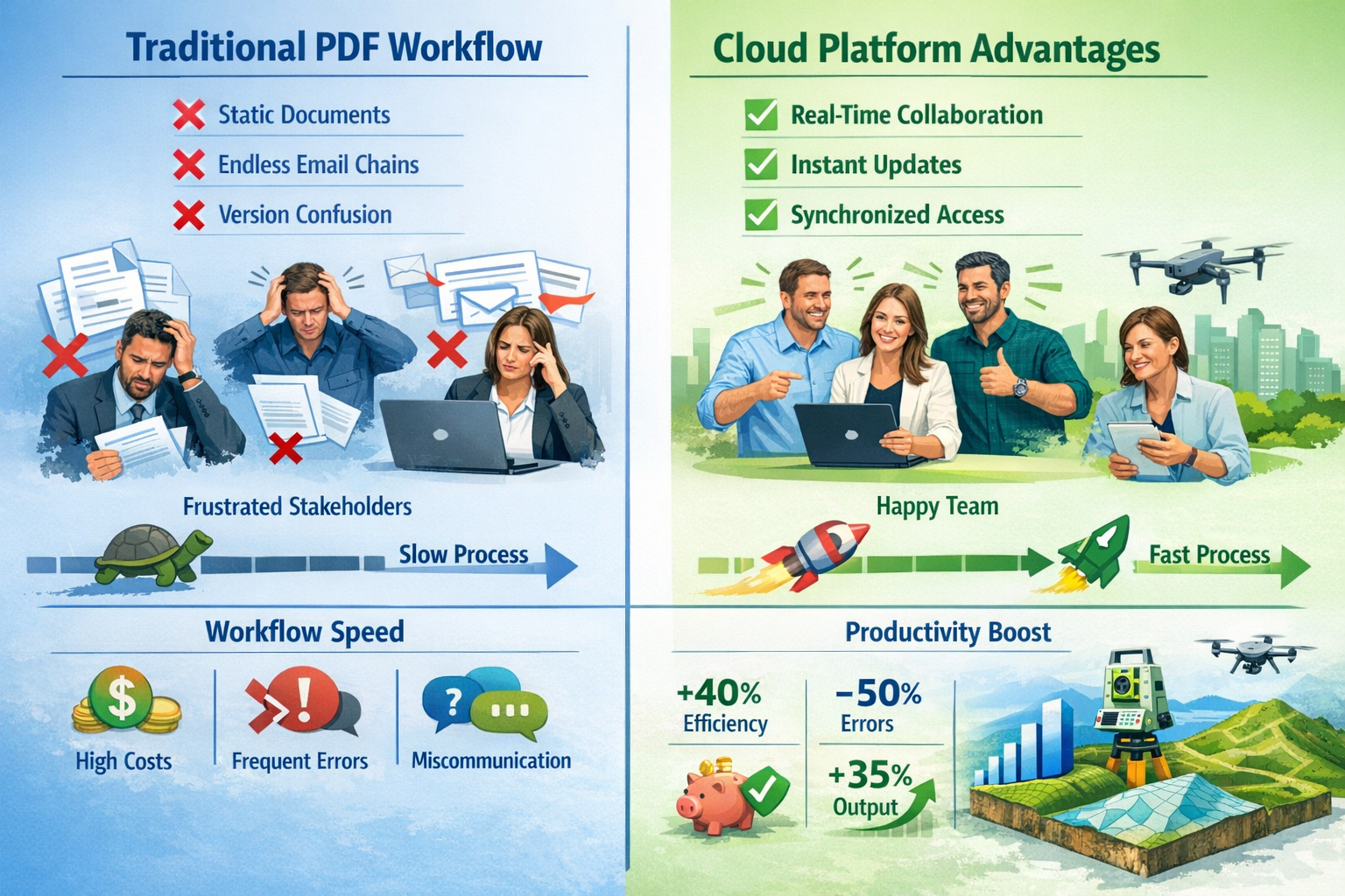
Traditional PDF Workflows: The Old Paradigm
For decades, surveying firms operated within a predictable workflow pattern. Field teams collected data using total stations, GPS receivers, and increasingly sophisticated laser scanners. Back at the office, technicians processed this information, produced CAD drawings, compiled comprehensive reports, and ultimately delivered static PDF documents to clients.
This traditional approach carried inherent limitations:
- Version control challenges when multiple stakeholders needed updates
- Communication delays requiring email exchanges for clarification
- Limited interactivity preventing clients from exploring data independently
- Software barriers requiring specialized CAD programs to view detailed drawings
- Collaboration bottlenecks when coordinating between architects, engineers, and contractors
While these methods served the industry adequately for years, they increasingly clash with 2026's project delivery expectations. Construction timelines have compressed, project complexity has increased, and stakeholder expectations have fundamentally shifted toward real-time information access.
The Cloud Revolution in Surveying
Cloud-based platforms for surveyors: instant sharing and real-time collaboration address these limitations through fundamentally different architecture. Rather than treating survey data as a finished product delivered at project milestones, cloud platforms position surveying information as a living resource continuously accessible throughout project lifecycles.
Modern platforms now deliver browser-based 3D visualization capabilities that were unimaginable just five years ago. Stakeholders access complete point cloud datasets, navigate through 3D models, perform measurements, and add annotations—all without installing specialized software[2][3]. This democratization of access transforms how construction teams interact with spatial information.
"In 2026, clients now expect interactivity, collaboration, and instant access to survey data rather than static PDF deliverables, fundamentally changing how surveying firms deliver results."[2]
The technological foundation enabling this transformation includes:
- Scalable cloud storage handling massive point cloud datasets (often hundreds of gigabytes)
- WebGL rendering providing smooth 3D navigation in standard web browsers
- Automated processing pipelines extracting features and generating deliverables
- Real-time synchronization ensuring all stakeholders view identical current data
- Granular permission controls maintaining security while enabling collaboration
Professional chartered surveyors across Kingston and surrounding regions are increasingly adopting these platforms to remain competitive and meet evolving client expectations.
Core Capabilities of Cloud-Based Platforms for Surveyors: Instant Sharing and Real-Time Collaboration
Browser-Based 3D Visualization
The most immediately visible advantage of cloud platforms is browser-based 3D visualization. Stakeholders simply receive a secure link, open it in Chrome, Safari, Firefox, or Edge, and immediately begin interacting with survey data. No downloads, no installations, no specialized training required for basic navigation.
These visualization environments typically include:
| Feature | Capability | Benefit |
|---|---|---|
| Point Cloud Navigation | Pan, zoom, rotate through millions of survey points | Intuitive spatial understanding |
| Measurement Tools | Distance, area, volume calculations directly in browser | Instant quantity verification |
| Cross-Sectioning | Dynamic slice planes revealing internal structures | Design validation and clash detection |
| Annotation Layers | Collaborative markup with comments and tags | Centralized communication |
| Orthophoto Overlay | High-resolution imagery draped over 3D terrain | Visual context and feature identification |
| Model Comparison | Side-by-side or overlay comparison of different survey dates | Progress tracking and change detection |
This accessibility fundamentally changes stakeholder engagement. Architects reviewing site conditions can explore terrain features themselves rather than requesting additional sections from surveyors. Contractors can verify measurements independently, reducing RFI (Request for Information) cycles. Project owners gain unprecedented transparency into site conditions and construction progress.
Revision Synchronization and Version Control
Traditional workflows struggled with version control. When survey data updated, firms would issue "Revision B" or "Version 2.1" PDFs, leading to confusion about which document represented current conditions. Team members working from outdated information made decisions based on superseded data, causing costly errors.
Cloud platforms eliminate this problem through automatic revision synchronization. When surveyors upload updated data or modify classifications, every stakeholder accessing the platform immediately sees current information. The system maintains complete revision history, allowing users to compare different survey dates or revert to previous versions when needed[2].
This capability proves particularly valuable for:
- Construction progress monitoring where weekly or monthly surveys track earthwork quantities
- As-built documentation requiring continuous updates as construction advances
- Deformation monitoring on infrastructure projects where millimeter-level changes matter
- Utility mapping where ongoing subsurface investigations reveal additional features
Commercial property surveyors in London particularly benefit from this capability when managing complex development projects requiring coordination among numerous consultants and contractors.
Stakeholder Communication and Collaboration Tools
Beyond visualization, modern platforms integrate communication tools directly within the spatial environment. Rather than exchanging emails describing "the area near the northeast corner," team members drop pins at specific 3D coordinates, attach comments, assign tasks, and track resolution—all georeferenced to exact locations[1].
Typical collaboration features include:
- Georeferenced comments pinned to specific survey points or features
- Issue tracking with assignment, status, and priority management
- Notification systems alerting relevant parties to updates or mentions
- Markup tools for highlighting areas requiring attention
- Discussion threads maintaining conversation history at specific locations
- Integration with project management platforms like Procore, Autodesk Construction Cloud, or BIM 360
This spatial communication eliminates ambiguity. When a structural engineer notes concern about foundation elevations, the comment exists precisely at the questioned location. Contractors reviewing the issue see exactly which area requires attention. Surveyors responding with additional measurements reference the identical coordinate system.
The result is dramatically reduced miscommunication and faster decision-making cycles[1]. Issues that previously required multiple email exchanges, phone calls, and site visits often resolve through platform-based collaboration, saving time and reducing project delays.
Unified Data Management Across Survey Types
Traditional surveying workflows often created data silos. Point clouds resided in one system, CAD drawings in another, orthophotos in a third, and vector base maps in yet another platform. Integrating these disparate datasets required manual effort and specialized expertise.
Modern cloud platforms adopt a unified approach, managing all spatial data types within a single environment[4]:
- Point clouds from terrestrial laser scanners, mobile mapping systems, and aerial LiDAR
- Photogrammetric models from drone surveys and close-range photography
- Orthophotos providing high-resolution planimetric imagery
- 3D meshes representing building exteriors and terrain surfaces
- Vector features including CAD drawings, utility networks, and boundary information
- BIM models for coordination with architectural and engineering designs
This integration eliminates data silos and reduces overhead. Surveyors upload raw data once, and the platform automatically processes, classifies, and makes it available across all relevant project views. Stakeholders access whatever data types they need through a consistent interface rather than juggling multiple specialized applications.
For surveying firms, this consolidation means reduced software licensing costs, simplified training requirements, and more efficient workflows. For clients, it means comprehensive access to all survey information through a single platform rather than navigating multiple systems.
Real-World Performance: Processing Speed and Efficiency Gains
Quantifying the Time Savings
The efficiency advantages of cloud-based platforms for surveyors: instant sharing and real-time collaboration extend beyond collaboration to fundamental processing performance. Traditional workflows required substantial manual effort and processing time, creating bottlenecks between field data collection and client deliverables.
Pointerra3D's Digital Surveyor Bundle demonstrates the magnitude of improvement possible. Their platform processes 1 square mile of surveyed data in approximately 30 minutes of manual time, encompassing upload, calibration, classification, feature extraction, orthophoto creation, and delivery[4]. Traditional workflows for comparable datasets typically required well over a day of processing time.
This dramatic acceleration results from several factors:
Automated processing pipelines that execute repetitive tasks without manual intervention
Cloud computing resources providing scalable processing power exceeding typical desktop workstations
Machine learning algorithms automatically classifying ground points, vegetation, buildings, and infrastructure
Parallel processing handling multiple tasks simultaneously rather than sequentially
Optimized data structures enabling efficient storage and retrieval of massive point cloud datasets
For surveying firms, these efficiency gains translate directly to improved profitability. Projects that previously consumed days of office processing time now complete in hours, allowing firms to handle higher project volumes with existing staff or redirect technical resources toward higher-value activities.
Scalable Processing Models
Cloud platforms typically offer tiered processing models aligned with project scale and frequency. Pointerra3D's approach exemplifies this structure with three bundle tiers[4]:
| Bundle Level | Processing Units (PUs) | Ideal For | Typical Use Cases |
|---|---|---|---|
| Explorer | 50 PUs | Small projects, occasional users | Individual site surveys, small developments |
| Adopter | 100 PUs | Regular users, medium projects | Weekly surveys, standard commercial projects |
| Pro | 500 PUs | Enterprise operations, large projects | Infrastructure corridors, campus developments, ongoing monitoring programs |
This model mirrors pricing structures from AWS, Google Cloud, and Microsoft Azure, providing predictable budgeting for surveying firms. Rather than unpredictable per-project costs or expensive perpetual software licenses, firms purchase processing capacity aligned with anticipated workload.
The scalability proves particularly valuable for firms experiencing seasonal variation or pursuing occasional large projects. Rather than maintaining expensive infrastructure for peak capacity that sits idle during slower periods, firms scale processing resources to match actual demand.
Common Data Environments: The Industry Standard for 2026
What Are Common Data Environments?
Common Data Environments (CDEs) represent perhaps the most significant structural shift in construction project delivery over the past decade. A CDE functions as a centralized digital repository where all project information—designs, specifications, schedules, correspondence, and increasingly, survey data—resides in a single, version-controlled environment accessible to all authorized stakeholders[5].
CDEs embody several core principles:
Single source of truth eliminating confusion about which information is current
Structured information management organizing data according to project phases and disciplines
Controlled access ensuring stakeholders see relevant information while maintaining security
Audit trails documenting who accessed, modified, or approved information and when
Workflow automation routing information through defined approval and review processes
For surveyors, CDEs represent a fundamental shift from isolated data providers to integrated contributors within dynamic project ecosystems[5]. Rather than delivering survey reports that exist separately from other project information, surveyors contribute spatial data directly into the shared environment where it immediately informs design decisions, construction planning, and quality verification.
Integration with Project Workflows
The integration of cloud-based platforms for surveyors: instant sharing and real-time collaboration with CDEs creates powerful synergies. Survey data doesn't merely exist alongside other project information—it actively informs and validates design and construction activities.
Typical integration workflows include:
Design validation: Architects and engineers overlay proposed designs on as-built survey data, identifying conflicts before construction begins
Quantity verification: Estimators calculate earthwork volumes directly from survey-derived terrain models, ensuring accurate bidding
Progress tracking: Weekly or monthly surveys compare actual construction against planned schedules, enabling early intervention when projects fall behind
Quality control: As-built surveys verify that constructed elements match design specifications and tolerances
Change management: Surveys document existing conditions when change orders arise, providing objective basis for cost negotiations
Professional building surveyor services increasingly emphasize CDE integration as a core competency, recognizing that clients expect seamless information flow rather than isolated deliverables.
Interoperability: Breaking Down Software Silos
Interoperability—the ability for different software systems to exchange and utilize information—has become a competitive necessity in 2026[5]. Construction projects involve dozens of specialized applications: BIM authoring tools, structural analysis programs, MEP coordination software, scheduling systems, cost estimating platforms, and more. Survey data must flow seamlessly into these varied environments.
Cloud surveying platforms address interoperability through multiple mechanisms:
Open file format support including LAS/LAZ point clouds, IFC models, DXF/DWG drawings, GeoTIFF imagery, and standard geodetic coordinate systems
API connections enabling automated data exchange with popular construction platforms like Autodesk Construction Cloud, Procore, Bentley ProjectWise, and Trimble Connect
Direct integrations with CAD and BIM software allowing designers to reference cloud-hosted survey data without downloading entire datasets
Export flexibility providing data in formats optimized for specific downstream applications
Coordinate system transformation automatically converting between different geodetic reference frames
This interoperability ensures that every stakeholder accesses spatial information within their preferred tools, regardless of platform[5]. Structural engineers working in Revit, civil engineers using Civil 3D, and contractors relying on Navisworks all reference identical survey data, eliminating discrepancies and coordination conflicts.
Advantages of Transitioning from Static PDFs in 2026 Projects
Enhanced Client Experience and Satisfaction
The client experience improvement represents perhaps the most compelling business case for cloud platforms. In 2026, clients—whether developers, architects, engineers, or property owners—expect digital experiences matching the convenience they encounter in other services.
Instant access eliminates frustration. Rather than waiting for email attachments or file transfer links, clients receive secure platform access and begin exploring survey data immediately. This responsiveness creates positive impressions and differentiates surveying firms in competitive markets.
Self-service capabilities empower clients to answer their own questions. When reviewing site topography, clients perform measurements, generate cross-sections, and extract elevations independently rather than submitting requests and waiting for surveyor responses. This autonomy increases satisfaction while reducing surveyor workload responding to routine inquiries.
Visual clarity improves understanding. Many clients struggle interpreting traditional 2D plans and cross-sections. Interactive 3D models provide intuitive spatial comprehension, particularly for stakeholders without technical surveying backgrounds. Property owners visualize proposed developments in context, municipalities review site conditions more effectively, and investors gain confidence in project feasibility.
Firms serving chartered surveyors in Richmond and similar markets report that cloud platform capabilities have become client expectations rather than differentiators—firms lacking these capabilities increasingly lose opportunities to competitors offering modern delivery methods.
Competitive Differentiation and Market Positioning
While cloud capabilities are becoming expected, firms implementing them effectively still gain competitive advantages in 2026:
Faster turnaround times enabled by automated processing allow firms to deliver results ahead of competitors still relying on manual workflows
Value-added services like automated change detection, progress monitoring dashboards, and integration with client BIM environments create additional revenue opportunities
Scalability to handle larger projects or higher volumes without proportional staff increases improves profitability and enables growth
Geographic flexibility allowing technical staff to work remotely expands talent pools and provides business continuity during disruptions
Professional image conveyed through modern technology demonstrates innovation and positions firms as industry leaders
Surveying firms that articulate these capabilities effectively in proposals and client presentations consistently report higher win rates and ability to command premium pricing compared to competitors offering traditional deliverables only.
Cost Reduction and Operational Efficiency
Beyond client-facing benefits, cloud platforms deliver substantial operational advantages:
Reduced software licensing costs: Consolidating multiple specialized applications into unified platforms decreases total software expenditure
Lower IT infrastructure requirements: Cloud hosting eliminates expensive server hardware, backup systems, and IT maintenance overhead[6]
Decreased storage costs: Cloud providers offer economical storage at scales impossible for individual firms to match
Minimized rework: Real-time collaboration and version control prevent errors caused by outdated information
Improved resource utilization: Automated processing frees technical staff for higher-value activities like client consultation and complex problem-solving
Faster invoicing cycles: Delivering results more quickly accelerates payment collection and improves cash flow
For many firms, these operational savings offset platform subscription costs, making cloud adoption financially neutral or even positive before considering revenue benefits from improved client satisfaction and competitive positioning.
Environmental and Sustainability Benefits
An often-overlooked advantage is the environmental impact of digital-first workflows. Traditional surveying generated substantial paper consumption: printed plans, bound reports, multiple copies for distribution, and archived hard copies for record-keeping.
Cloud platforms virtually eliminate this paper usage. Stakeholders access digital information on screens rather than printed sheets. Markups and annotations occur digitally rather than on physical plans. Long-term archiving happens in cloud storage rather than filing cabinets.
For firms pursuing sustainability certifications or serving environmentally-conscious clients, this digital transformation aligns with broader corporate responsibility goals and demonstrates commitment to reducing environmental footprint.
Challenges and Considerations When Transitioning from PDFs
Security and Data Protection Concerns
While cloud platforms offer numerous advantages, they also introduce security considerations that surveying firms must address carefully. Survey data often contains sensitive information: property boundaries, infrastructure locations, security system placements, or commercially confidential development plans.
Key security considerations include:
Data encryption: Ensuring information encrypts both in transit (during upload/download) and at rest (stored on cloud servers)
Access controls: Implementing granular permissions determining who views, edits, or shares specific datasets
Authentication methods: Requiring strong passwords, multi-factor authentication, or single sign-on integration
Audit logging: Tracking who accessed what information and when for accountability and compliance
Data sovereignty: Understanding where cloud providers physically store data and whether this complies with regulatory requirements
Backup and disaster recovery: Confirming cloud providers maintain redundant backups and can restore data if systems fail
Compliance certifications: Verifying platforms meet relevant standards like ISO 27001, SOC 2, GDPR, or industry-specific requirements
Reputable cloud platforms address these concerns through enterprise-grade security measures often exceeding what individual surveying firms could implement with on-premises infrastructure. However, firms must conduct due diligence, understand security features, and configure platforms appropriately for their specific risk tolerance and regulatory environment.
For projects involving particularly sensitive information—military installations, critical infrastructure, or high-security facilities—firms may need to maintain traditional delivery methods or seek specialized secure cloud environments meeting enhanced security requirements.
Training and Change Management
Technology adoption succeeds or fails based on people and processes, not merely software capabilities. Transitioning from familiar PDF workflows to cloud platforms requires thoughtful change management.
Common implementation challenges include:
Staff resistance: Experienced surveyors comfortable with established workflows may resist new methods
Learning curves: Even intuitive platforms require time investment to master fully
Workflow redesign: Optimizing cloud platform benefits often requires rethinking established processes
Client education: Stakeholders unfamiliar with cloud platforms need guidance accessing and using data
Quality control adaptation: Review and approval processes designed for PDF deliverables may need modification
Successful transitions typically involve:
Phased rollout starting with internal projects or willing clients before full deployment
Comprehensive training including hands-on practice, documentation, and ongoing support
Champion identification recruiting enthusiastic early adopters who help colleagues adapt
Clear communication explaining why changes occur and how they benefit both firm and clients
Patience and iteration recognizing that process optimization takes time and refinement
Firms should budget 3-6 months for meaningful adoption, with full optimization often taking a year or more. Rushing implementation without adequate preparation typically results in frustration, resistance, and suboptimal outcomes.
Client Readiness and Adoption Barriers
While many clients eagerly embrace cloud platforms, others present adoption barriers:
Technology limitations: Clients with poor internet connectivity, outdated computers, or restrictive IT policies may struggle accessing cloud platforms
Generational preferences: Some stakeholders, particularly in traditional industries, strongly prefer familiar PDF formats
Internal processes: Client organizations with established document management systems may resist external platforms
Learning investment: Busy stakeholders may lack time to learn new tools, defaulting to familiar formats
Legal and contractual requirements: Some contracts or regulations specifically mandate certain deliverable formats
Surveying firms address these barriers through hybrid approaches:
Offering cloud platform access as the primary delivery method while providing PDF exports for stakeholders requiring them
Creating simplified viewer links requiring minimal technical knowledge
Providing brief video tutorials or quick-start guides for client stakeholders
Scheduling demonstration sessions showing clients platform capabilities
Maintaining flexibility to accommodate legitimate client preferences while encouraging modern methods
The goal is meeting clients where they are while gently encouraging adoption of more efficient methods. Firms that dogmatically insist on cloud-only delivery may lose opportunities to competitors offering flexibility during this transitional period.
Cost Structures and Budget Considerations
Cloud platforms introduce different cost structures compared to traditional software licensing:
Subscription models replace perpetual licenses with recurring monthly or annual fees
Usage-based pricing charges based on data volume, processing units, or active users
Tiered plans offer different feature sets at various price points
Per-project pricing charges separately for each project or dataset
These structures offer advantages (predictable budgeting, no large upfront investments, automatic updates) but also require financial planning adjustments. Firms must:
Calculate total cost of ownership comparing cloud subscriptions against traditional software licenses, IT infrastructure, and maintenance
Project usage patterns estimating data volumes and processing requirements to select appropriate plans
Budget for ongoing costs ensuring subscription fees fit long-term financial planning
Evaluate ROI quantifying efficiency gains, competitive advantages, and client satisfaction improvements
Plan for scalability understanding how costs change as firm grows or project volumes fluctuate
For most surveying firms, cloud platforms prove cost-competitive or advantageous compared to traditional infrastructure, particularly when accounting for reduced IT overhead, improved efficiency, and competitive benefits. However, careful analysis specific to each firm's situation remains essential.
Selecting the Right Cloud Platform for Your Surveying Practice
Essential Features to Evaluate
Not all cloud platforms offer equivalent capabilities. When evaluating options, surveying firms should assess:
Data type support: Does the platform handle all spatial data types your firm produces (point clouds, imagery, CAD drawings, BIM models)?
Processing capabilities: What automated processing does the platform provide (classification, feature extraction, orthophoto generation)?
Visualization quality: How smoothly do 3D models render? Can the platform handle your typical dataset sizes?
Collaboration tools: What communication and markup capabilities exist?
Integration options: Does the platform connect with software your clients use?
Mobile access: Can stakeholders access data effectively on tablets and smartphones?
Customization flexibility: Can you brand the platform with your firm identity and customize workflows?
Support quality: What training resources, documentation, and technical support does the vendor provide?
Pricing structure: Do costs align with your project types and volumes?
Vendor stability: Is the company financially sound with a track record of continued development?
Firms should trial multiple platforms with representative project data before committing, ideally involving both technical staff and typical clients in evaluation to ensure solutions meet all stakeholder needs.
Industry-Leading Platforms in 2026
Several platforms have emerged as leaders for cloud-based platforms for surveyors: instant sharing and real-time collaboration:
Pointerra3D excels in point cloud processing and visualization, offering powerful automated feature extraction and the Digital Surveyor Bundle specifically designed for surveying workflows[4]
Autodesk Construction Cloud provides comprehensive project delivery integration, connecting survey data with BIM workflows and construction management
Trimble Connect offers tight integration with Trimble field hardware and office software, creating seamless workflows for Trimble-equipped firms
Bentley iTwin specializes in infrastructure projects and digital twin applications, particularly strong for long-term asset management
Propeller Aero focuses on construction earthwork and drone survey workflows, offering excellent progress tracking and volume calculation
Site Scan (formerly DroneDeploy) provides accessible drone survey processing with strong visualization and collaboration features
Leica TruView integrates well with Leica scanning hardware, offering reliable point cloud hosting and sharing
Each platform has strengths for particular use cases, firm sizes, and project types. The "best" choice depends on your specific requirements, existing technology ecosystem, and client preferences.
Implementation Strategy and Best Practices
Successful cloud platform implementation follows structured approaches:
Phase 1: Assessment and Planning (1-2 months)
- Evaluate current workflows and identify improvement opportunities
- Define requirements and success criteria
- Research and trial potential platforms
- Develop implementation timeline and budget
Phase 2: Pilot Program (2-3 months)
- Select 2-3 suitable projects for initial implementation
- Train core team members thoroughly
- Document lessons learned and refine processes
- Gather feedback from clients and staff
Phase 3: Expanded Rollout (3-6 months)
- Train all relevant staff members
- Implement platform for most new projects
- Develop standard operating procedures
- Create client education materials
Phase 4: Optimization (Ongoing)
- Continuously refine workflows based on experience
- Explore advanced features and integrations
- Monitor metrics (turnaround times, client satisfaction, profitability)
- Stay current with platform updates and new capabilities
Throughout implementation, maintain open communication with staff about changes, challenges, and successes. Celebrate wins, address concerns promptly, and remain flexible as you discover what works best for your specific practice.
The Future Trajectory: Where Cloud Collaboration Is Heading
Reality Capture as Core Differentiator
Reality capture—comprehensive documentation of existing conditions through laser scanning, photogrammetry, and other technologies—is becoming a core service differentiator for surveying firms in 2026[5]. Cloud platforms amplify this trend by making reality capture data accessible and actionable for entire project teams.
Surveyors increasingly position themselves not merely as measurers of property boundaries but as spatial information providers who document conditions, visually track progress, and enable collaborative problem-solving through shared 3D environments[5]. This expanded role creates new revenue opportunities and strengthens client relationships.
AI and machine learning enhance reality capture value by automatically extracting meaningful information from raw scan data: identifying building components, classifying vegetation, detecting changes between survey dates, and flagging potential issues requiring attention[3]. These automated insights transform massive point clouds from overwhelming data dumps into actionable intelligence.
Visualization-Driven Design Workflows
Design conversations increasingly occur directly within 3D models rather than traditional 2D plans[5]. Architects, engineers, and clients navigate shared virtual environments, discussing design options while surrounded by accurate as-built context. This visualization-driven approach enables:
Quicker design iterations as stakeholders immediately see how modifications affect the overall project
Faster decision-making when everyone shares identical visual understanding
Reduced misunderstandings compared to abstract 2D representations
Enhanced creativity as designers explore options in immersive 3D space
Surveyors providing the foundational spatial data for these visualization-driven workflows become essential project participants rather than peripheral service providers. Cloud platforms that seamlessly integrate survey data into design environments position surveying firms at the center of project collaboration.
Integration with Emerging Technologies
Cloud platforms increasingly integrate with emerging technologies creating new capabilities:
Artificial intelligence automatically classifies features, detects anomalies, and predicts maintenance needs from survey data[3]
Augmented reality overlays design models on real-world views using smartphones or AR glasses, with survey data providing precise georeferencing
Digital twins create virtual replicas of physical assets continuously updated with survey data for ongoing monitoring and optimization
IoT sensors combine with periodic surveys to track structural movement, settlement, or environmental conditions
Blockchain potentially provides immutable records of survey data for legal and compliance purposes
5G connectivity enables real-time streaming of survey data from field to office and clients
These integrations expand what's possible with survey data, creating opportunities for surveying firms to offer higher-value services beyond traditional measurement and mapping.
Workforce Evolution and Remote Collaboration
Cloud platforms fundamentally change where and how surveying work occurs. Processing and quality control no longer require physical presence in a specific office. Technical staff work effectively from home offices, regional locations, or while traveling. This geographic flexibility:
Expands talent pools by enabling firms to hire skilled professionals regardless of location
Improves work-life balance reducing commute time and offering schedule flexibility
Enhances business continuity ensuring operations continue during local disruptions
Enables global collaboration connecting expertise across time zones and continents
For surveying firms, this workforce evolution requires adapting management approaches, communication practices, and company culture. However, it also creates competitive advantages in attracting and retaining top talent increasingly prioritizing remote work options.
Practical Steps for Surveying Firms Considering Cloud Adoption

Starting Small: Pilot Projects and Gradual Implementation
Firms uncertain about cloud platform adoption should start small rather than attempting immediate wholesale transformation:
Select a pilot project with characteristics favoring cloud delivery:
- Willing client open to new approaches
- Multiple stakeholders requiring coordination
- Moderate complexity (not too simple, not overwhelmingly complex)
- Timeline allowing adequate implementation time
Define success metrics before beginning:
- Stakeholder satisfaction ratings
- Time from field completion to data availability
- Number of coordination issues resolved through platform
- Staff time required compared to traditional workflows
Document the experience thoroughly:
- What worked well?
- What challenges arose?
- How did clients respond?
- What would you do differently next time?
Share results with your team and use insights to refine your approach for subsequent projects.
This measured approach reduces risk, builds organizational confidence, and creates internal champions who help drive broader adoption.
Building Client Awareness and Demand
Rather than waiting for clients to request cloud delivery, proactive firms create demand by educating clients about benefits:
Include platform demonstrations in project proposals and kickoff meetings
Create case studies showing how cloud collaboration improved outcomes on previous projects
Offer pilot programs where willing clients experience cloud delivery at no additional cost
Develop educational content (blog posts, videos, webinars) explaining cloud platform advantages
Highlight specific benefits relevant to each client type:
- Developers: faster approvals and reduced coordination delays
- Architects: seamless integration with design workflows
- Contractors: real-time progress tracking and quantity verification
- Property owners: transparent access to project information
By positioning cloud platforms as value-added services rather than technical details, firms differentiate themselves and justify premium pricing.
Investing in Staff Development
Technology alone doesn't create value—skilled professionals using it effectively do. Firms should invest in:
Comprehensive training programs covering both technical platform operation and strategic application
Continuing education keeping staff current with evolving capabilities and best practices
Cross-training ensuring multiple team members can handle cloud platform responsibilities
Mentorship programs pairing experienced staff with those learning new technologies
Industry conference attendance exposing staff to broader trends and networking opportunities
Certification programs when platforms offer formal credentialing
Staff development represents an ongoing investment, not a one-time expense. As platforms evolve and add capabilities, continuous learning ensures your firm maximizes value from these tools.
Measuring ROI and Demonstrating Value
To justify cloud platform investments and guide optimization, firms should track relevant metrics:
Efficiency metrics:
- Processing time per project
- Staff hours from field completion to deliverable
- Rework hours due to coordination issues
Client satisfaction metrics:
- Net Promoter Score (NPS)
- Client retention rates
- Testimonials and referrals
Financial metrics:
- Win rate on proposals
- Average project profitability
- Revenue per technical staff member
Competitive metrics:
- Market share in target segments
- Premium pricing achievement
- New service offerings enabled
Regular review of these metrics helps firms quantify cloud platform value, identify optimization opportunities, and make data-driven decisions about technology investments.
Conclusion: Embracing the Cloud Revolution in Surveying
Cloud-based platforms for surveyors: instant sharing and real-time collaboration represent far more than incremental technological improvement. They fundamentally transform how surveying professionals create, deliver, and derive value from spatial information. In 2026, the transition from static PDF deliverables to interactive, collaborative cloud environments has progressed from emerging trend to industry expectation.
The advantages are compelling: instant stakeholder access, seamless collaboration, dramatic efficiency gains, reduced miscommunication, and enhanced client satisfaction. Firms successfully implementing these platforms report competitive advantages in winning projects, commanding premium pricing, and attracting top talent. The operational benefits—reduced IT overhead, scalable processing capacity, and automated workflows—often offset subscription costs while improving profitability.
Yet challenges remain. Security concerns require careful platform evaluation and configuration. Change management demands thoughtful implementation strategies and staff training. Client adoption varies, necessitating flexible approaches during this transitional period. Cost structures differ from traditional software licensing, requiring financial planning adjustments.
The trajectory is clear: cloud platforms will continue evolving, integrating emerging technologies like AI, augmented reality, and digital twins. Visualization-driven design workflows will become standard. Reality capture will expand from specialized service to core surveying competency. Firms positioning themselves at the forefront of these trends will thrive; those clinging to traditional methods will increasingly struggle to compete.
Actionable Next Steps
For surveying firms ready to embrace cloud-based platforms for surveyors: instant sharing and real-time collaboration:
-
Assess your current state: Honestly evaluate existing workflows, identifying pain points and improvement opportunities
-
Research available platforms: Trial 2-3 solutions with representative project data, involving both technical staff and typical clients in evaluation
-
Develop an implementation plan: Create a phased rollout strategy with defined milestones, success metrics, and contingency approaches
-
Invest in training: Ensure staff have skills and confidence to use platforms effectively, not merely access to software
-
Start with pilot projects: Test approaches with willing clients on suitable projects before full deployment
-
Educate your clients: Proactively demonstrate cloud platform benefits rather than waiting for client requests
-
Measure and optimize: Track relevant metrics, learn from experience, and continuously refine your approach
-
Stay informed: Monitor industry trends, platform developments, and emerging best practices through professional organizations and continuing education
The surveying profession stands at a pivotal moment. Firms embracing cloud collaboration position themselves as innovative leaders delivering exceptional value through modern technology. Those hesitating risk becoming outdated service providers struggling to meet evolving client expectations.
Whether you're a chartered surveyor in Kingston, South West London, or anywhere else, the message remains consistent: cloud-based platforms for surveyors: instant sharing and real-time collaboration aren't the future—they're the present. The question isn't whether to adopt these technologies, but how quickly and effectively your firm will integrate them into your service delivery model.
The revolution has arrived. The choice is yours: lead it, follow it, or be left behind by it. Choose wisely, act decisively, and embrace the tremendous opportunities cloud collaboration offers the surveying profession in 2026 and beyond. 🚀
References
[1] The Future Of Surveying In Wa – https://www.harleydykstra.com.au/post/the-future-of-surveying-in-wa
[2] Future Land Surveying 2026 – https://haller-blanchard.com/future-land-surveying-2026/
[3] Ai Driven Precision In Land Surveying How Artificial Intelligence Is Transforming Data Collection And Analysis – https://nottinghillsurveyors.com/blog/ai-driven-precision-in-land-surveying-how-artificial-intelligence-is-transforming-data-collection-and-analysis
[4] Transforming The Future Of Survey Mapping – https://www.geoweeknews.com/news/transforming-the-future-of-survey-mapping
[5] Doubling Down On Digital – https://amerisurv.com/2026/02/01/doubling-down-on-digital/
[6] The Future Of Land Surveying Technology And Upcoming Trends In 2026 – https://metricop.com/blogs/land-surveying/the-future-of-land-surveying-technology-and-upcoming-trends-in-2026