The construction industry stands at a pivotal moment in 2026. A land surveyor arrives at a development site in London, captures precise geospatial data with advanced scanning equipment, and within hours, that information flows seamlessly into a Building Information Modeling (BIM) platform where architects, engineers, and contractors simultaneously access, analyze, and integrate it into their design workflows. This scenario represents the transformative power of BIM Integration for Land Surveyors: Seamless Collaboration in Construction Projects—a fundamental shift from isolated data silos to interconnected digital ecosystems that are revolutionizing how construction projects are planned, executed, and delivered.
Gone are the days when surveyors delivered static reports that sat disconnected from design processes. Today's construction environment demands that geospatial professionals feed accurate, real-time data directly into collaborative BIM models, enabling early conflict detection, optimized site analysis, and unprecedented coordination among project stakeholders. This integration doesn't just improve efficiency—it fundamentally transforms the surveyor's role from data collector to strategic collaborator in the construction lifecycle.
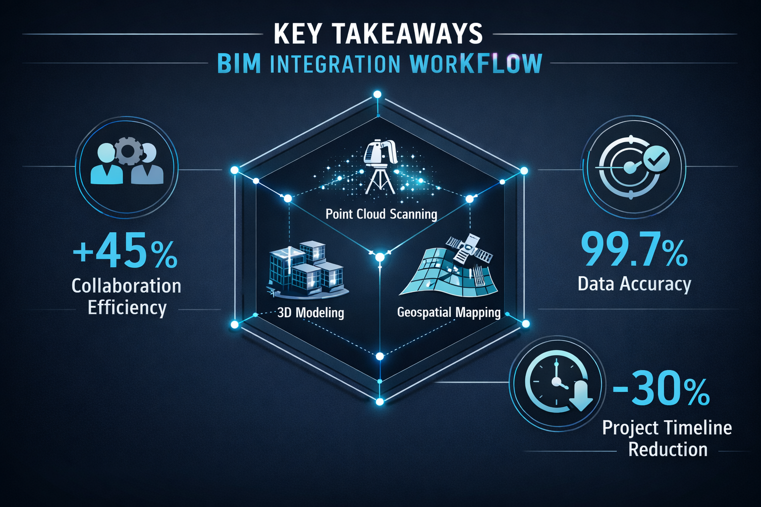
Key Takeaways
- Cloud-based BIM platforms enable land surveyors to share geospatial data instantly with architects, engineers, and contractors, replacing static documents with interactive 3D models accessible to all stakeholders in real-time[1]
- Early conflict detection through GIS-BIM integration allows teams to identify and resolve design clashes during the planning phase, preventing costly construction delays and rework[4]
- Enhanced site analysis capabilities combine topographical surveys with BIM models to evaluate soil conditions, environmental constraints, and infrastructure conflicts before breaking ground
- Surveyors provide the foundational accuracy that makes BIM models reliable—construction cannot proceed without properly surveyed land, and valid BIM models cannot exist without real-world geospatial parameters[3]
- Professional expertise remains essential despite technological advances, as BIM integration requires surveyors with deep geospatial knowledge and systems expertise to ensure data quality and project success[3]
Understanding BIM Integration for Land Surveyors: Seamless Collaboration in Construction Projects
What Is BIM Integration in Land Surveying?
Building Information Modeling integration represents the systematic incorporation of precise geospatial data into comprehensive digital construction models. For land surveyors, this means capturing site conditions, topography, existing structures, and underground utilities in formats that seamlessly feed into collaborative digital environments rather than traditional isolated workflows[5].
BIM integration transforms surveying deliverables from:
- Static PDF reports → Interactive 3D point clouds
- Isolated CAD drawings → Collaborative cloud-based models
- One-time data delivery → Continuous data synchronization
- Technical documentation → Strategic planning tools
The fundamental principle underlying BIM integration is that accurate surveying data forms the virtual and physical foundation of all construction models. Without properly surveyed land and precise real-world parameters, BIM models cannot reflect actual site conditions, leading to design conflicts, construction errors, and project delays[3].
The Evolution of Surveying Collaboration in 2026
The construction industry has witnessed a dramatic transformation in how surveying data integrates with project workflows. In 2026, clients expect interactive, collaborative access to surveying deliverables rather than static documents. Cloud-based platforms now enable instant file sharing, 3D browser visualization, real-time revision syncing, and integrated communication with engineers and architects[1].
This evolution reflects several key technological and professional developments:
📊 Cloud Computing Adoption: Construction teams access survey data from any location, on any device, with automatic synchronization across all stakeholders
🔄 Real-Time Data Integration: Survey measurements flow directly into BIM platforms without manual data transfer or format conversion
🤝 Collaborative Workflows: Surveyors work alongside architects and engineers within shared digital environments, providing immediate feedback on design feasibility
⚡ Automated Quality Control: BIM systems automatically flag discrepancies between survey data and design specifications, enabling rapid resolution
Professional commercial property surveyors increasingly recognize that BIM proficiency has become as essential as traditional surveying skills for competitive practice in 2026.
Why BIM Integration Matters for Construction Success
The integration of surveying data with BIM platforms delivers measurable benefits across the entire construction lifecycle:
Reduced Construction Conflicts: Early detection and resolution of design clashes before construction begins prevents costly rework and schedule delays[4]
Enhanced Communication: Shared digital models eliminate misunderstandings between surveyors, designers, and contractors by providing a single source of truth
Improved Accuracy: BIM integration reduces human error in construction by ensuring the physical build aligns precisely with computer-designed specifications[2]
Cost Savings: Identifying conflicts during design costs significantly less than discovering them during construction when materials, labor, and equipment are already committed
Project Monitoring: Real-time tracking of construction progress against BIM models enables immediate identification of deviations from planned specifications[4]
A 2026 contractor survey revealed that construction professionals increasingly demand BIM-skilled surveyors, recognizing the efficiency gains and conflict reduction from integrated collaboration[1]. This growing demand reflects the industry's recognition that BIM integration has transitioned from competitive advantage to essential requirement.
The Technical Foundation: How Surveyors Feed Geospatial Data into BIM Models
Data Capture Technologies and Formats
Modern land surveyors employ sophisticated technologies to capture site conditions with precision suitable for BIM integration. The key is ensuring captured data formats seamlessly integrate with collaborative digital environments[5].
Primary Data Capture Methods:
| Technology | Accuracy | Best Applications | BIM Integration |
|---|---|---|---|
| Total Stations | ±2-5mm | Boundary surveys, control points, detailed features | Direct coordinate export to BIM platforms |
| GPS/GNSS | ±10-20mm | Large site mapping, topographic surveys, control networks | Real-time kinematic (RTK) data feeds |
| Terrestrial LiDAR | ±3-6mm | Complex structures, as-built documentation, point clouds | Native point cloud import to BIM software |
| UAV/Drone Photogrammetry | ±20-50mm | Large area mapping, progress monitoring, terrain modeling | Orthophotos and 3D meshes for BIM context |
| Mobile Mapping Systems | ±10-30mm | Corridor surveys, urban environments, rapid data collection | Georeferenced point clouds and imagery |
The critical requirement for BIM integration is that survey data must include accurate geospatial coordinates that align with project coordinate systems. Surveyors establish control networks that ensure all data—regardless of capture method—references the same coordinate framework used throughout the BIM model[3].
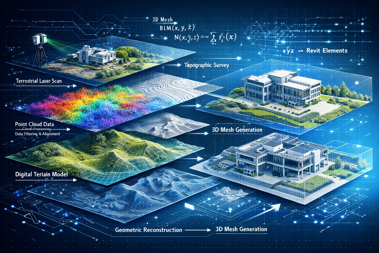
Point Cloud Processing and Model Integration
Point clouds represent one of the most valuable surveying deliverables for BIM integration. These dense collections of three-dimensional coordinates capture existing site conditions with exceptional detail, enabling architects and engineers to design around actual rather than assumed conditions.
Point Cloud Integration Workflow:
- Data Capture: LiDAR or photogrammetry scanning of site conditions
- Registration: Aligning multiple scans using control points or cloud-to-cloud matching
- Cleaning: Removing noise, vegetation, and irrelevant features
- Classification: Identifying ground, buildings, utilities, and other features
- Export: Formatting data for BIM platform import (typically .RCP, .RCS, or .E57 formats)
- Integration: Loading point clouds into BIM software as reference geometry
- Modeling: Creating BIM elements that accurately reflect surveyed conditions
Modern BIM platforms can display point clouds alongside design models, enabling visual comparison between existing conditions and proposed construction. This capability allows teams to identify conflicts before they become construction problems—for example, discovering that a proposed foundation would intersect with an existing underground utility revealed in the survey data[4].
Coordinate Systems and Geospatial Accuracy
One of the most critical technical aspects of BIM integration involves establishing and maintaining consistent coordinate systems throughout the project lifecycle. Surveyors serve as the geospatial experts who ensure all project data aligns within a unified spatial framework.
Essential Coordinate System Considerations:
🎯 Project Origin: Establishing a local coordinate system origin that minimizes large coordinate values while maintaining geospatial accuracy
📍 Datum Selection: Choosing appropriate horizontal and vertical datums that align with local standards and existing infrastructure
🔄 Transformation Parameters: Documenting conversions between GPS coordinates, local grid systems, and BIM coordinate spaces
📏 Precision Requirements: Maintaining appropriate accuracy levels for different project elements (foundations require millimeter precision; site grading may accept centimeter tolerance)
The surveyor's role extends beyond simply capturing data—they provide the geospatial expertise that ensures BIM models occupy correct real-world positions. This expertise becomes particularly critical when integrating GIS data (which typically uses geographic coordinates) with BIM models (which often use local engineering coordinates)[4].
Professional surveyors working on complex projects often establish comprehensive coordinate system documentation that guides all project stakeholders in maintaining spatial consistency throughout design and construction phases.
GIS-BIM Integration: Creating Comprehensive Digital Construction Solutions
The Power of Combined GIS and BIM Platforms
Geographic Information Systems (GIS) and Building Information Modeling represent complementary technologies that, when integrated, unlock capabilities far exceeding either system alone. GIS excels at managing large-scale geographic data, environmental analysis, and infrastructure networks, while BIM focuses on detailed building design, construction sequencing, and facility management[4].
Combined GIS-BIM Capabilities:
✅ 3D Visualization: Viewing proposed buildings within accurate geographic context including terrain, existing structures, and infrastructure
✅ Scenario Simulation: Testing design alternatives against real-world constraints like flood zones, sight lines, and environmental regulations
✅ Conflict Detection: Identifying clashes between proposed construction and existing utilities, easements, or protected areas before construction begins
✅ Asset Management: Creating comprehensive databases linking building components to geographic locations for long-term facility management
✅ Environmental Analysis: Evaluating project impacts on watersheds, viewsheds, solar exposure, and ecological systems
The integration of these platforms enables what construction professionals call "digital twins"—comprehensive virtual representations of construction projects that incorporate both detailed building information and broad geographic context. Land surveyors provide the critical geospatial data that anchors these digital twins to real-world coordinates[4].
Enhanced Site Analysis Through Integration
One of the most valuable applications of GIS-BIM integration involves comprehensive site analysis during project planning phases. By combining surveyed topography with GIS environmental data and BIM design models, teams can evaluate potential sites with unprecedented thoroughness.
Integrated Site Analysis Components:
🏔️ Topographic Evaluation: Surveyed elevation data reveals grading requirements, drainage patterns, and earthwork volumes
🌍 Soil Conditions: GIS soil databases combined with geotechnical surveys identify foundation challenges and construction constraints
💧 Hydrological Analysis: Watershed delineation, flood zone mapping, and stormwater management planning using combined datasets
🌳 Environmental Constraints: Protected habitats, wetlands, and conservation areas identified through GIS layers verified by field surveys
🏗️ Infrastructure Context: Existing utilities, roads, and structures from GIS databases verified and supplemented by detailed surveying
This comprehensive analysis allows architects and engineers to visualize how proposed designs fit into existing landscapes, identify potential conflicts early, and optimize designs for specific geographic contexts[4]. For example, a 2026 case study from a London development project demonstrated how GIS-BIM integration revealed conflicts between proposed foundation depths and underground transportation infrastructure that wasn't visible in traditional design workflows, preventing what would have been a multi-million-pound construction delay.
Real-Time Collaboration and Conflict Resolution
Perhaps the most transformative aspect of BIM integration for land surveyors involves the shift from sequential to simultaneous collaboration. Rather than completing surveys, delivering reports, and waiting for designers to incorporate findings, surveyors now work directly within integrated BIM environments alongside other project stakeholders.
Collaborative Workflow Benefits:
Early Conflict Detection: Architects, engineers, and contractors detect and resolve design conflicts during the design phase rather than during construction, when changes cost exponentially more[4]
Immediate Feedback: Surveyors can immediately inform designers when proposed elements conflict with site conditions, enabling rapid design adjustments
Continuous Verification: Throughout construction, surveyors perform ongoing surveys that update BIM models, ensuring projects remain on track and identifying deviations from design specifications[3]
Integrated Communication: Cloud-based platforms enable team members to comment, question, and resolve issues directly within the BIM environment rather than through separate email chains or meetings[1]
Progress Monitoring: Construction teams monitor progress against schedule and budget in real-time while identifying deviations from the plan using integrated survey and BIM data[4]
Experienced building surveyor services professionals recognize that this collaborative approach requires not only technical proficiency but also strong communication skills and understanding of how different disciplines use surveying data throughout the construction lifecycle.
Practical Implementation: Best Practices for Surveyors in 2026

Establishing BIM Integration Workflows
Successful BIM integration requires surveyors to develop systematic workflows that ensure data quality, format compatibility, and timely delivery to project teams. The following framework represents best practices emerging from successful 2026 construction projects:
Phase 1: Project Initiation
- Participate in BIM kickoff meetings to understand project requirements and coordinate systems
- Establish data exchange protocols with architects, engineers, and contractors
- Define accuracy requirements for different project elements
- Agree on file formats, naming conventions, and delivery schedules
- Set up cloud-based collaboration platforms with appropriate access permissions
Phase 2: Data Capture Planning
- Coordinate survey control networks with project coordinate systems
- Select appropriate capture technologies based on accuracy requirements and site conditions
- Plan scan locations to ensure complete coverage with minimal occlusions
- Schedule surveys to minimize conflicts with other site activities
Phase 3: Data Processing
- Process point clouds and survey measurements to project accuracy standards
- Clean and classify data to highlight relevant features for BIM integration
- Export data in formats compatible with project BIM platforms
- Perform quality control checks before delivery
Phase 4: BIM Integration
- Upload survey data to cloud-based collaboration platforms
- Coordinate with BIM managers to ensure proper data alignment
- Verify that survey data displays correctly within BIM environments
- Document any coordinate transformations or adjustments
Phase 5: Ongoing Collaboration
- Respond to design team questions about survey data and site conditions
- Perform verification surveys during construction to ensure alignment with BIM models
- Update BIM models with as-built survey data as construction progresses
- Participate in coordination meetings to resolve conflicts identified through BIM analysis
This systematic approach ensures that surveying data integrates seamlessly with BIM workflows rather than creating bottlenecks or requiring extensive manual processing by other team members.
Technology Selection and Training
The rapid evolution of surveying technology and BIM platforms requires continuous learning and strategic technology investments. Surveyors must balance the capabilities of cutting-edge equipment with practical considerations of cost, training requirements, and project needs.
Essential Technology Competencies for 2026:
📱 Cloud Platform Proficiency: Understanding how to upload, share, and manage survey data on platforms like Autodesk Construction Cloud, Trimble Connect, or Bentley ProjectWise
🖥️ BIM Software Familiarity: Working knowledge of major BIM platforms (Revit, ArchiCAD, Tekla) to understand how survey data integrates with design workflows
📊 Point Cloud Processing: Expertise with software like ReCap, CloudCompare, or Leica Cyclone for processing and preparing LiDAR data
🗺️ GIS Integration: Understanding how to work with GIS platforms (ArcGIS, QGIS) and exchange data between GIS and BIM environments
🔧 Equipment Operation: Proficiency with modern surveying equipment including robotic total stations, GNSS receivers, and terrestrial laser scanners
Despite the sophistication of modern technology, professional expertise remains irreplaceable. LiDAR scanners and advanced equipment do not transform surveying into a point-and-click operation for unskilled operators. Surveying requires professionals with deep geospatial knowledge and systems expertise to ensure data quality, accuracy, and appropriate application[3].
Forward-thinking surveying firms invest in continuous professional development, ensuring team members maintain current knowledge of both surveying fundamentals and emerging BIM integration practices. This commitment to expertise distinguishes professional surveyors from technicians simply operating equipment.
Quality Control and Data Validation
The integration of surveying data into BIM models amplifies both the value of accurate data and the consequences of errors. A survey mistake that might have been caught during manual drafting review can propagate throughout an integrated BIM model, affecting multiple design disciplines before detection.
Comprehensive Quality Control Procedures:
Field Verification: Checking critical measurements with independent methods before leaving the site
Closure Analysis: Verifying that survey traverses and control networks meet accuracy standards through mathematical closure checks
Point Cloud Validation: Comparing LiDAR data against traditional survey measurements at key locations to verify scanner calibration and registration accuracy
Coordinate System Verification: Confirming that all data aligns properly within project coordinate systems before delivery
Visual Inspection: Reviewing point clouds and survey data visually to identify obvious errors, noise, or missing data
BIM Integration Testing: Loading survey data into BIM platforms and verifying proper alignment, scale, and orientation before project-wide distribution
Documentation: Maintaining comprehensive metadata describing survey methods, accuracy estimates, coordinate systems, and any limitations or assumptions
These quality control measures protect both the surveyor's professional reputation and the project's success. When survey data feeds directly into collaborative BIM environments accessed by dozens of stakeholders, errors become immediately visible and potentially costly.
Professional surveyors working on high-stakes projects often implement independent verification procedures where different team members check critical measurements and data processing steps, providing additional assurance of data quality.
Case Studies: BIM Integration Success in 2026 Construction Projects
Case Study 1: Mixed-Use Development in Central London
A major mixed-use development project in central London demonstrated the transformative impact of comprehensive BIM integration for land surveyors in 2026. The project involved constructing a 25-story residential and commercial tower on a constrained urban site surrounded by historic buildings, active underground transit lines, and complex utility networks.
Project Challenges:
- Extremely limited site access with adjacent buildings within 3 meters
- Underground transit tunnels requiring precise foundation placement
- Historic building preservation requirements
- Complex existing utility networks with incomplete documentation
- Tight construction timeline with significant financial penalties for delays
BIM Integration Approach:
The surveying team employed terrestrial LiDAR scanning to capture existing conditions of the site and all adjacent structures, creating a comprehensive point cloud with sub-centimeter accuracy. This data was integrated with GIS utility databases and historical construction records within a cloud-based BIM platform accessible to the entire project team.
Crucially, the surveying team discovered significant discrepancies between documented utility locations and actual field conditions. The integrated BIM model revealed that proposed foundation piles would intersect with a previously undocumented high-pressure gas line—a conflict that would have caused catastrophic construction delays if discovered during excavation.
Results:
- ✅ Conflict detected and resolved during design phase, saving an estimated 8-week construction delay
- ✅ Foundation design adjusted based on accurate survey data, optimizing structural efficiency
- ✅ Adjacent building monitoring integrated with BIM model, providing real-time settlement tracking
- ✅ Project completed 3 weeks ahead of schedule with zero utility conflicts during construction
- ✅ Client reported 15% cost savings compared to similar projects without BIM integration
This case study exemplifies how commercial dilapidation survey expertise combined with BIM integration delivers measurable project value.
Case Study 2: Infrastructure Corridor Development
A 2026 transportation infrastructure project involving a new railway corridor through varied terrain demonstrated the power of GIS-BIM integration for large-scale surveying applications. The 45-kilometer corridor traversed urban areas, agricultural land, environmentally sensitive wetlands, and challenging topography.
Project Requirements:
- Comprehensive topographic mapping of 200-meter-wide corridor
- Environmental constraint identification and avoidance
- Integration with existing transportation infrastructure
- Coordination among multiple engineering disciplines
- Public stakeholder engagement with visualization tools
Integrated Survey and BIM Workflow:
The surveying team deployed a combination of UAV photogrammetry for broad area mapping and terrestrial LiDAR for detailed infrastructure documentation. This data was integrated with extensive GIS environmental databases including wetland delineations, protected species habitats, soil classifications, and existing infrastructure networks.
The combined GIS-BIM platform enabled engineers to test multiple alignment alternatives, automatically calculating earthwork volumes, identifying environmental conflicts, and optimizing the corridor for construction efficiency. The visual capabilities of the integrated model proved particularly valuable during public consultation meetings, where stakeholders could view proposed construction within accurate geographic context[4].
Outcomes:
- 🌍 Three environmentally sensitive areas avoided through early conflict detection
- 📊 Earthwork optimization reduced material movement by 23% compared to initial design
- 🏗️ Coordination with existing infrastructure prevented 12 potential utility conflicts
- 👥 Public engagement improved through accessible 3D visualizations
- ⏱️ Design phase compressed by 6 weeks through efficient collaboration
Case Study 3: Heritage Building Renovation
A complex renovation project involving a Grade II listed building in Oxford showcased how BIM integration enables surveyors to support preservation efforts while accommodating modern construction requirements.
Project Complexity:
- Detailed documentation of historic fabric requiring preservation
- Integration of modern building systems within historic structure
- Structural assessment requiring precise deformation monitoring
- Coordination among conservation architects, structural engineers, and MEP designers
- Regulatory compliance with heritage preservation requirements
Survey and BIM Integration Strategy:
The surveying team employed high-resolution terrestrial LiDAR scanning to create a comprehensive as-built BIM model of the existing structure with millimeter-level accuracy. This detailed point cloud captured architectural details, structural deformations, and spatial constraints that would govern renovation design.
The point cloud was integrated directly into the BIM platform where architects and engineers designed new interventions. The ability to design within the context of precise existing conditions proved invaluable—engineers could verify that proposed structural reinforcements would fit within available spaces, and MEP designers could route building systems around historic elements requiring preservation.
Throughout construction, the surveying team performed periodic monitoring surveys to track structural movements, updating the BIM model with actual deformation data and enabling immediate response to any concerning trends[3].
Project Benefits:
- 🏛️ Zero damage to protected historic fabric through precise construction planning
- 🔍 Structural monitoring detected minor movement trends, enabling preventive interventions
- ⚙️ MEP system routing optimized to minimize impact on historic elements
- 📋 Regulatory approval accelerated through comprehensive documentation
- 💰 Construction budget maintained through conflict avoidance and precise quantity takeoffs
These case studies demonstrate that BIM integration for land surveyors delivers concrete, measurable value across diverse project types and scales. The common thread is that accurate geospatial data, properly integrated with collaborative digital platforms, enables better decisions throughout the construction lifecycle.
Overcoming Common Challenges in BIM Integration
Technical Compatibility and Data Exchange
Despite significant progress in BIM standardization, surveyors still encounter technical challenges when exchanging data across different platforms and software environments. Different BIM platforms use varying coordinate systems, units, and file formats, creating potential for errors during data exchange.
Common Compatibility Challenges:
File Format Variations: While Industry Foundation Classes (IFC) provides a standardized exchange format, not all BIM platforms implement IFC identically, leading to data loss or misinterpretation during exchange
Coordinate System Confusion: BIM platforms often use local coordinate systems with arbitrary origins, while survey data uses georeferenced coordinate systems, requiring careful transformation
Unit Inconsistencies: Mixing metric and imperial units across international project teams creates opportunities for catastrophic errors
Point Cloud Size Limitations: High-resolution LiDAR scans can generate point clouds too large for some BIM platforms to handle efficiently
Software Version Compatibility: Different team members using different software versions may experience compatibility issues
Practical Solutions:
Establish clear data exchange protocols during project initiation meetings, documenting required formats, coordinate systems, and units. Implement systematic verification procedures where data is checked after exchange to confirm proper transfer. Consider using neutral file formats like IFC or point cloud standards (E57, LAS) that maintain broader compatibility across platforms.
Many successful projects designate a BIM manager responsible for coordinating data exchange across all disciplines, ensuring consistency and resolving technical issues before they impact project schedules.
Professional Liability and Data Accuracy
BIM integration raises important questions about professional liability and responsibility for data accuracy. When survey data integrates with design models created by multiple disciplines, determining responsibility for errors becomes complex.
Liability Considerations:
Scope Definition: Clearly defining what the surveyor is responsible for measuring and documenting versus what other disciplines contribute
Accuracy Standards: Establishing and documenting appropriate accuracy levels for different project elements and survey deliverables
Data Limitations: Communicating limitations of survey data, including areas not surveyed, accuracy estimates, and assumptions
Professional Standards: Maintaining compliance with professional surveying standards and regulations regardless of delivery format
Insurance Coverage: Ensuring professional liability insurance adequately covers BIM integration activities and collaborative workflows
Contractual Clarity: Developing contracts that clearly allocate responsibility among project participants
Professional surveyors protect themselves through comprehensive documentation of survey methods, accuracy estimates, and data limitations. Clear communication about what survey data represents—and what it doesn't—helps manage expectations and prevent misunderstandings that could lead to liability claims.
Many surveyors working on BIM-integrated projects include metadata with deliverables documenting survey dates, methods, equipment used, accuracy estimates, coordinate systems, and any limitations or assumptions. This documentation provides essential context for data users and protects the surveyor's professional interests.
Training and Skill Development
The rapid evolution of BIM technology and surveying equipment creates ongoing training challenges for surveying professionals and firms. Maintaining current knowledge requires continuous learning and professional development investments.
Skill Development Priorities:
BIM Software Proficiency: Understanding major BIM platforms sufficiently to effectively integrate survey data and collaborate with design teams
Cloud Platform Navigation: Competence with cloud-based collaboration platforms that enable data sharing and team communication
Advanced Processing Techniques: Expertise in point cloud processing, classification, and optimization for BIM integration
Coordinate System Management: Deep understanding of coordinate transformations, datums, and spatial reference systems
Interdisciplinary Communication: Ability to communicate effectively with architects, engineers, and contractors who may have limited surveying knowledge
Quality Control Procedures: Systematic approaches to verifying data accuracy and identifying errors before delivery
Forward-thinking surveying firms invest in structured training programs, professional conference attendance, vendor training sessions, and mentorship programs that transfer knowledge from experienced practitioners to newer team members. This investment in human capital distinguishes professional firms from competitors relying solely on equipment capabilities.
The growing demand for BIM-skilled surveyors creates significant career opportunities for professionals who develop these competencies[1]. Surveyors who combine traditional geospatial expertise with modern BIM integration skills position themselves for leadership roles in the evolving construction industry.
The Future of BIM Integration for Land Surveyors
Emerging Technologies and Trends
The trajectory of BIM integration continues to accelerate, with several emerging technologies poised to further transform how surveyors collaborate with construction teams in the coming years.
Artificial Intelligence and Machine Learning: AI algorithms are increasingly capable of automatically classifying point cloud data, identifying features, and detecting changes between survey datasets. This automation reduces manual processing time while maintaining accuracy standards[2].
Augmented Reality Visualization: AR technology enables surveyors and construction teams to visualize BIM models overlaid on actual site conditions through mobile devices or specialized headsets, improving spatial understanding and conflict detection.
Automated Monitoring Systems: Permanent monitoring installations using robotic total stations or photogrammetry systems provide continuous survey data throughout construction, automatically updating BIM models and alerting teams to deviations from design specifications.
Digital Twin Maturity: The evolution from static BIM models to dynamic digital twins that incorporate real-time sensor data, construction progress, and operational information creates new opportunities for surveyors to provide ongoing geospatial services throughout building lifecycles[7].
5G Connectivity: Enhanced mobile network speeds enable real-time transmission of large survey datasets from field to office, accelerating data delivery and enabling immediate collaboration.
Blockchain for Data Verification: Emerging applications of blockchain technology provide immutable records of survey data provenance, accuracy certifications, and modification history, enhancing trust in collaborative BIM environments.
These technological advances will continue to enhance surveyor capabilities while reinforcing the importance of professional expertise. Technology amplifies the impact of skilled professionals but cannot replace the judgment, experience, and geospatial knowledge that define professional surveying practice[3].
Evolving Professional Roles and Opportunities
BIM integration is fundamentally reshaping the surveyor's role within construction project teams. Rather than operating as isolated data providers, surveyors increasingly function as integrated team members contributing throughout the project lifecycle.
Expanding Surveyor Responsibilities:
BIM Coordination: Some surveyors take on broader BIM management roles, coordinating data exchange among all project disciplines
Quality Assurance: Verifying that construction aligns with BIM models through ongoing verification surveys and as-built documentation
Conflict Resolution: Participating in coordination meetings where design conflicts are identified and resolved using integrated BIM models
Client Advisory: Helping clients understand BIM requirements, benefits, and implementation strategies for their projects
Training and Mentorship: Educating other project team members about surveying capabilities, limitations, and best practices for using geospatial data
This evolution creates significant career opportunities for surveyors who develop both technical competencies and collaborative skills. The construction industry increasingly recognizes that effective BIM integration requires professionals who understand both geospatial science and construction processes—a combination that defines modern professional surveying practice.
Surveyors working with expert witness report requirements recognize that BIM integration also enhances their ability to provide comprehensive documentation and analysis in dispute resolution contexts.
Industry Standardization and Best Practices
As BIM integration matures, the construction industry continues developing standards and best practices that guide implementation. Several organizations contribute to this standardization effort:
ISO 19650: International standards for information management using BIM provide frameworks for organizing project information, defining roles and responsibilities, and establishing data exchange protocols
National BIM Standards: Country-specific standards (like the UK BIM Framework) provide detailed implementation guidance adapted to local regulatory environments and construction practices
Professional Society Guidelines: Organizations like RICS (Royal Institution of Chartered Surveyors) publish guidance on BIM integration for surveying professionals, establishing professional standards and best practices
Industry Protocols: Construction industry groups develop practical protocols for specific applications like clash detection, quantity takeoff, and as-built documentation
Surveyors benefit from engaging with these standardization efforts, both to stay current with evolving requirements and to contribute professional expertise that shapes how standards address geospatial aspects of BIM integration.
The trend toward standardization creates opportunities for surveyors to differentiate their practices through demonstrated compliance with recognized standards and certifications. Clients increasingly seek professionals who can demonstrate systematic, standards-based approaches to BIM integration rather than ad hoc implementations.
Conclusion: Embracing the Collaborative Future
BIM Integration for Land Surveyors: Seamless Collaboration in Construction Projects represents far more than a technological trend—it fundamentally transforms how construction projects are conceived, designed, and executed. The shift from isolated data delivery to integrated collaboration positions surveyors as strategic partners throughout the construction lifecycle, contributing expertise that prevents conflicts, optimizes designs, and ensures successful project outcomes.
The evidence from 2026 construction projects demonstrates conclusively that BIM integration delivers measurable value: reduced conflicts, compressed schedules, optimized costs, and improved quality. Projects that effectively integrate accurate geospatial data with collaborative BIM platforms consistently outperform those relying on traditional sequential workflows[1][4].
For land surveyors, this transformation creates both challenges and opportunities. The technical requirements of BIM integration demand continuous learning and technology investments. The collaborative nature of integrated workflows requires communication skills and interdisciplinary understanding beyond traditional surveying expertise. Yet these challenges pale compared to the opportunities: enhanced professional recognition, expanded service offerings, and central roles in shaping construction's digital future.
Actionable Next Steps for Surveyors
Immediate Actions:
- Assess Current Capabilities: Evaluate your firm's current BIM integration capabilities, identifying gaps in technology, training, or processes
- Invest in Core Technologies: Acquire or upgrade essential tools including point cloud processing software and cloud collaboration platforms
- Develop Team Competencies: Implement training programs that build BIM software proficiency and collaborative workflow skills
- Establish Quality Protocols: Document systematic procedures for data capture, processing, quality control, and BIM integration
- Engage with Project Teams: Participate actively in BIM coordination meetings, contributing geospatial expertise to design discussions
Medium-Term Strategies:
- Build Strategic Partnerships: Develop relationships with architects, engineers, and contractors who value BIM integration and collaborative workflows
- Pursue Professional Development: Attend conferences, workshops, and training programs focused on BIM integration and emerging technologies
- Document Success Stories: Create case studies demonstrating the value your BIM integration services deliver to clients
- Contribute to Standards: Engage with professional organizations developing BIM standards and best practices
- Expand Service Offerings: Consider how BIM integration enables new services like construction monitoring, digital twin development, or facility management support
Long-Term Vision:
Position your surveying practice as an essential partner in collaborative construction, recognized for both technical excellence and strategic contribution to project success. The surveyors who thrive in 2026 and beyond will be those who embrace integration, invest in capabilities, and demonstrate the irreplaceable value of professional geospatial expertise in increasingly digital construction environments.
The future of construction is collaborative, digital, and data-driven. Land surveyors who master BIM integration position themselves at the center of this transformation, providing the accurate geospatial foundation upon which successful construction projects are built. The question is not whether to embrace BIM integration, but how quickly and effectively to develop the capabilities that define professional surveying excellence in the collaborative construction era.
For surveyors seeking to enhance their professional capabilities and service offerings, embracing BIM Integration for Land Surveyors: Seamless Collaboration in Construction Projects represents not just an opportunity but an essential evolution in professional practice. The construction industry's digital transformation continues to accelerate—and surveyors who lead this integration will shape the built environment for decades to come.
References
[1] Future Land Surveying 2026 – https://haller-blanchard.com/future-land-surveying-2026/
[2] The Future Of Engineering Surveying Technology Tools And Trend – https://2survey.com.au/the-future-of-engineering-surveying-technology-tools-and-trend/
[3] Bim In Surveying – https://onekeyresources.milwaukeetool.com/en/bim-in-surveying
[4] Gis And Bim – https://www.datumate.com/blog/gis-and-bim/
[5] Bim Integration For Surveyors Bridging Geospatial Data And Construction Planning – https://nottinghillsurveyors.com/blog/bim-integration-for-surveyors-bridging-geospatial-data-and-construction-planning
[6] Future Construction Technology Trends Contractor Survey – https://www.trimble.com/blog/trimble/en-US/article/future-construction-technology-trends-contractor-survey
[7] How Bim Market Transforming Global Construction – https://www.nxtsyg.com/blog/how-bim-market-transforming-global-construction/