The e-commerce revolution has transformed industrial real estate from a niche asset class into an essential cornerstone of global commerce. As online shopping continues its explosive growth in 2026, the demand for strategically located, technologically advanced distribution centers has reached unprecedented levels. Surveying Industrial and Logistics Hubs: Meeting 2026 E-Commerce Distribution Demands represents a critical intersection where traditional surveying expertise meets cutting-edge logistics infrastructure requirements.
The global e-commerce logistics market has surged to $624.33 billion in 2026, with projections indicating growth to $2,498.8 billion by 2034—a remarkable CAGR of 18.93%[3]. This explosive expansion is driving a fundamental shift in how industrial facilities are planned, designed, and constructed. Surveyors now face unprecedented challenges: verifying floor flatness tolerances measured to within millimeters across football-field-sized warehouse floors, laying out crane pad foundations capable of supporting 500-ton loads, and assessing roof structural capacity for solar panel installations that can power entire neighborhoods.
Gone are the days when warehouse surveying meant simple boundary verification. Today's hyperscale distribution centers demand precision engineering at every stage, from initial site selection through final commissioning. Surveying Industrial and Logistics Hubs: Meeting 2026 E-Commerce Distribution Demands requires specialized knowledge of automated material handling systems, understanding of high-density storage configurations, and expertise in coordinating complex multi-phase construction projects that cannot afford downtime.
Key Takeaways
📊 Market Growth: The global e-commerce logistics market reached $624.33 billion in 2026, with warehousing services growing at the fastest rate of 20.81% CAGR[3]
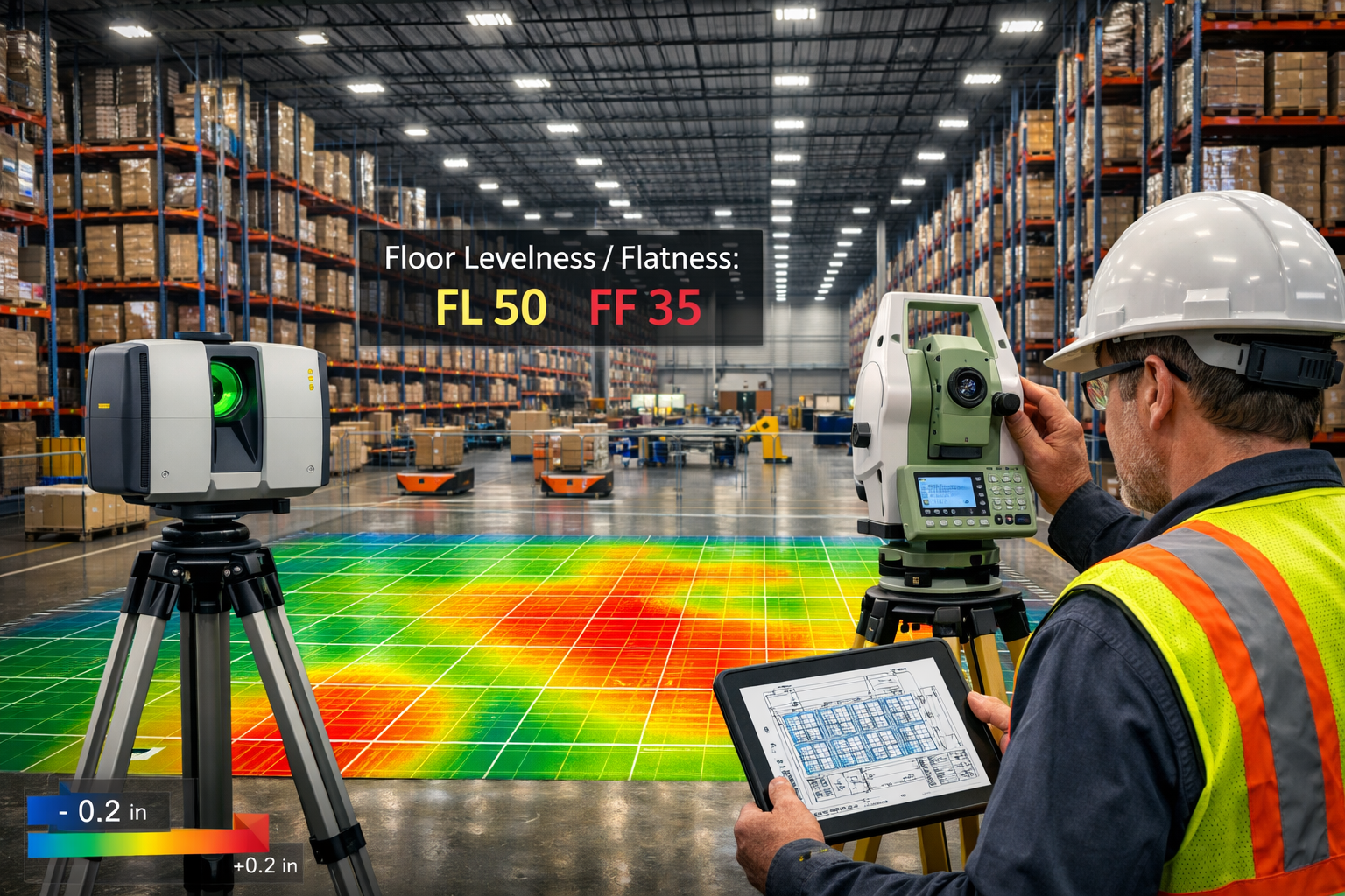
🎯 Precision Requirements: Modern distribution centers require floor flatness specifications of FL 50/FF 35 or better to support automated guided vehicles and robotic systems
🏗️ Hyperscale Challenges: Surveying projects now involve facilities exceeding 1 million square feet with clear heights of 40+ feet, demanding advanced laser scanning and GPS control networks
⚡ Infrastructure Integration: Roof surveys must assess structural capacity for solar installations, while site surveys coordinate utility corridors for high-voltage power and fiber optic networks
🚀 Strategic Positioning: The U.S. Midwest enables reach to 90% of households within two truck-days, making precise site selection and surveying critical for competitive advantage[2]
The E-Commerce Logistics Boom Reshaping Industrial Real Estate
Understanding the 2026 Market Landscape
The transformation of industrial real estate into a premium asset class reflects fundamental shifts in consumer behavior and supply chain strategy. The United States e-commerce logistics market alone is worth USD 162.42 billion in 2026, expanding at a CAGR of 7.66% to reach USD 234.98 billion by 2031[2]. This growth trajectory has triggered an unprecedented construction boom, with developers racing to deliver modern distribution facilities that meet increasingly sophisticated operational requirements.
Asia Pacific dominates globally, valued at USD 269.31 billion in 2026, representing the largest regional market[3]. This geographic concentration reflects rising internet penetration and consumer spending power across developing economies. However, the surveying challenges differ dramatically between regions—from navigating complex land tenure systems in Southeast Asia to managing seismic design requirements in Japan and California.
The domestic segment represents USD 277.7 billion in market value, driven by decentralized networks that position inventory closer to end consumers[1]. This decentralization strategy creates unique surveying demands, as companies develop networks of smaller "last-mile" facilities in urban areas alongside massive regional distribution centers in suburban and exurban locations.
Regional Distribution Patterns and Site Selection
Geographic strategy plays a crucial role in e-commerce success, and surveyors contribute essential data for site selection decisions. The U.S. South controls 31.60% of regional revenue, leveraging competitively priced real estate and direct Gulf and Atlantic port access[2]. Major retailers are clustering mega-fulfillment centers along I-10 and I-75 corridors, where surveyors establish control networks across sites spanning hundreds of acres.
These Southern facilities achieve 24-hour truck turnarounds and intermodal rail connections, requiring precise coordination of rail spur layouts, truck court configurations, and trailer parking areas. Surveyors must verify clearance envelopes for double-stack rail cars, establish grade elevations for drainage across vast paved areas, and coordinate utility corridors that snake through complex site plans.
The Midwest is strategically positioned to reach 90% of contiguous U.S. households within two truck-days[2], making it a key secondary stocking hub. This geographic advantage drives demand for surveying services in markets like Columbus, Indianapolis, and Kansas City, where agricultural land is rapidly converting to industrial use. Understanding what survey you need becomes critical when evaluating these greenfield sites.
APAC is contributing over 57% of incremental global market opportunity[1], creating surveying challenges unique to rapidly developing markets. Land acquisition often involves consolidating multiple parcels with unclear boundaries, requiring extensive boundary surveys and title research. Infrastructure deficiencies mean surveyors must also assess road access, utility availability, and flood risk—factors that Western markets often take for granted.
Technology-Driven Warehouse Design Requirements
Modern distribution centers bear little resemblance to the simple box warehouses of previous decades. Automated sortation systems in urban distribution centers are reporting 25% throughput increases[1], but these systems demand extraordinary precision in floor construction and building alignment. Surveyors establish control networks with accuracy measured in millimeters, not inches, to ensure automated guided vehicles (AGVs) can navigate safely.
Warehousing services are growing at 20.81% CAGR—the fastest rate among service segments—with robotics and automation enabling efficient operations[3]. This automation boom creates new surveying specializations. Floor flatness verification using laser-guided equipment has become a distinct service line, with specifications typically requiring FL 50/FF 35 or better across the entire slab. These measurements use the Face Floor Profile Number (FF) and Face Levelness (FL) system, where higher numbers indicate flatter, more level floors.
Leading e-fulfillment platform operators are reducing processing variability by over 20% through real-time shipment tracking and advanced order orchestration systems[1]. The physical infrastructure supporting these systems—from conveyor networks to automated storage and retrieval systems (AS/RS)—requires surveying precision that rivals aerospace manufacturing. Rack aisle alignments must be verified to ensure automated cranes can operate at high speeds without collision risk.
Early adopters of advanced predictive demand forecasting with autonomous mobile robots report 15% improvements in forecast accuracy[1]. These mobile robots navigate using a combination of sensors, but floor conditions remain critical. Uneven joints, settlement, or waviness can cause navigation errors or even tip over heavily loaded units. Surveyors now conduct post-construction verification surveys to document as-built conditions and identify areas requiring remediation before robotic systems go live.
Surveying Industrial and Logistics Hubs: Technical Challenges and Solutions
Floor Flatness and Levelness: The Foundation of Automation
The most critical surveying challenge in modern distribution centers involves verifying superflat floor specifications. Traditional warehouse floors were poured to basic levelness standards, with variations of 1/4 inch over 10 feet considered acceptable. Today's automated facilities demand FL 50/FF 35 or better, with some robotic installations requiring even tighter tolerances of FL 75/FF 50.
Floor flatness (FF) measures the bumpiness or waviness of the floor surface over short distances, while floor levelness (FL) measures the overall tilt or slope over longer distances. These measurements use specialized equipment including:
- Laser-guided profilers that measure elevation changes as they're rolled across the floor
- Digital levels with data logging capabilities for continuous elevation mapping
- Laser scanning systems that capture millions of elevation points for comprehensive analysis
- GPS-based surveying equipment for establishing primary control networks
The surveying process typically occurs in multiple phases. Initial surveys establish site control and verify subgrade preparation. Intermediate surveys check formwork alignment and embedded plates for racking systems. Final surveys verify the finished concrete surface meets specifications before the contractor receives final payment.
Failure to meet floor flatness specifications can have severe consequences. Automated storage systems may experience premature wear on wheels and bearings. AGVs may navigate erratically or shut down entirely. Racking systems may require expensive shimming and adjustment. In extreme cases, floors must be ground flat or overlaid with self-leveling compounds—remediation that can cost millions of dollars and delay facility openings by months.
Surveyors working on these projects must understand concrete construction sequencing, laser screed operations, and the relationship between floor specifications and equipment requirements. They coordinate closely with concrete contractors, equipment suppliers, and facility operators to ensure everyone understands the tolerances and verification methods.
Crane Pad and Heavy Equipment Foundation Surveys
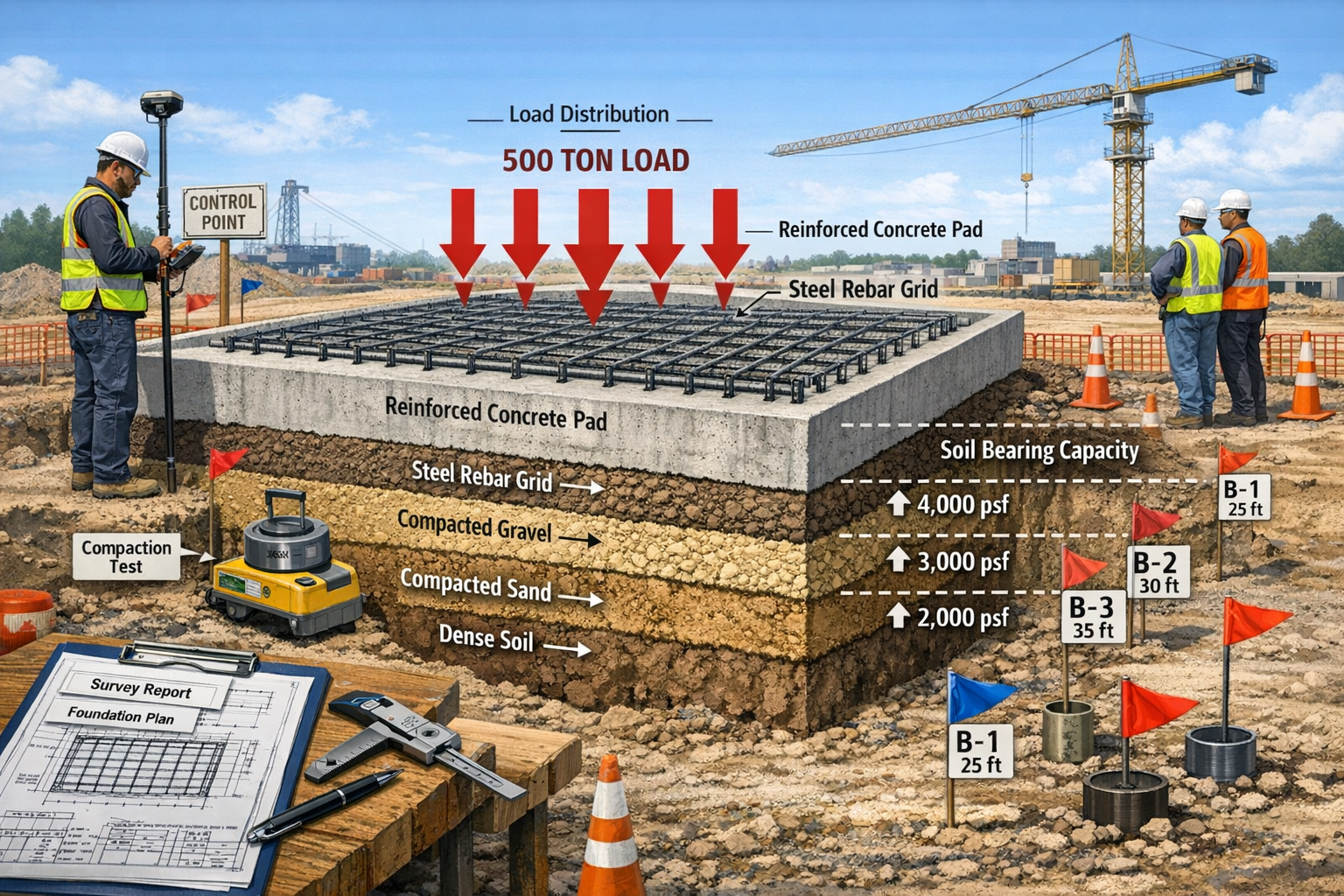
Hyperscale distribution centers increasingly incorporate automated storage towers reaching 100 feet or more in height. These structures require specialized foundations called crane pads that must be surveyed with extraordinary precision. A typical crane pad foundation might measure 30 feet by 30 feet and extend 10 feet below grade, reinforced with heavy rebar cages designed to support concentrated loads exceeding 500 tons.
Surveying crane pad locations involves multiple critical steps:
Site Layout and Control: Surveyors establish primary control points using GPS or total station networks, then stake out the exact location of each crane pad. Positioning accuracy of ±1/4 inch is typical, as any misalignment can cause problems when the automated storage system is installed months later.
Excavation Verification: As excavation proceeds, surveyors verify depth, width, and bottom elevation. Soil conditions must be documented, and any unexpected findings (rock outcrops, soft zones, groundwater) require immediate communication with geotechnical engineers.
Formwork and Rebar Inspection: Before concrete placement, surveyors verify formwork dimensions and rebar placement. Embedded anchor bolts or plates must be positioned within extremely tight tolerances—often ±1/8 inch—as these will later receive the crane rail or tower structure with no opportunity for adjustment.
Post-Pour Verification: After concrete curing, surveyors conduct final verification of pad elevation, levelness, and anchor bolt positions. Any deviations outside tolerance must be documented and remediation plans developed. For projects requiring structural survey expertise, understanding load paths and foundation performance becomes essential.
The stakes are high. A crane pad positioned even one inch out of location can cause alignment problems throughout the entire automated storage system. Anchor bolts installed at incorrect elevations may prevent proper equipment installation. These errors typically aren't discovered until equipment arrives on site, at which point corrections are extremely expensive and time-consuming.
Roof Structural Surveys for Solar Integration
Sustainability initiatives are driving rapid adoption of rooftop solar installations on distribution centers. These massive facilities offer ideal conditions: large unshaded roof areas, high energy consumption, and long-term ownership or leases. However, adding solar panels to an existing or planned facility requires comprehensive roof structural surveys.
A typical hyperscale distribution center might have 500,000 to 1,000,000 square feet of roof area. Covering this area with solar panels adds significant dead load—typically 3 to 5 pounds per square foot for the panels, racking, and mounting systems. Surveyors must assess whether the existing structure can support this additional load or whether reinforcement is required.
The roof surveying process includes:
Structural Documentation: Surveyors create accurate as-built drawings of the roof structure, documenting beam spacing, purlin locations, roof deck type, and existing penetrations. This often involves roof survey techniques adapted for industrial applications, including laser scanning to capture the entire roof geometry.
Load Path Analysis Coordination: Working with structural engineers, surveyors identify optimal mounting locations that align with structural members capable of supporting additional loads. This prevents point loads on unsupported roof deck areas that could cause deflection or failure.
Elevation and Slope Mapping: Accurate elevation data helps solar designers optimize panel layout and predict energy production. Even slight variations in roof slope affect panel angles and shading patterns. Surveyors use laser scanning or photogrammetry to create detailed digital elevation models.
Obstruction and Access Documentation: Rooftop HVAC units, skylights, access hatches, and other obstructions must be precisely located so solar designers can work around them. Access routes for installation crews and future maintenance must also be identified and verified.
Drainage Verification: Adding solar panels can alter roof drainage patterns. Surveyors verify that existing drains, scuppers, and gutters are properly located and that the roof maintains positive drainage to all drain points. Ponding water can damage roofing membranes and reduce solar panel efficiency.
For new construction, surveyors coordinate with architects and engineers to ensure the building is "solar-ready" from the beginning. This includes verifying that structural members are sized appropriately, conduit pathways are installed for electrical runs, and roof access points are properly located.
Site Civil Engineering and Utility Coordination
Beyond the building itself, distribution center sites require extensive civil engineering and utility infrastructure. Modern facilities consume enormous amounts of electrical power—often 5 to 10 megawatts or more for a fully automated facility. They also require robust fiber optic networks for warehouse management systems, redundant water supplies for fire suppression, and sophisticated stormwater management systems.
Surveyors play a crucial role in coordinating these systems:
Utility Corridor Layout: High-voltage electrical feeds, telecommunications conduits, water mains, and sanitary sewers must be precisely located to avoid conflicts. Surveyors establish horizontal and vertical alignments, verify trench depths, and document as-built locations for future reference.
Stormwater Management: Large paved areas generate massive runoff volumes. Surveyors establish grades for parking lots, truck courts, and trailer storage areas to ensure positive drainage to collection systems. They verify detention pond volumes, outlet structure elevations, and emergency spillway capacities.
Truck Court and Dock Configuration: Loading docks must be surveyed with precision to ensure proper alignment with building doors. Truck courts require specific slopes for drainage while maintaining level areas where trailers will be spotted. Surveyors verify clearances for truck circulation, turning radii, and trailer parking angles.
Rail Spur Alignment: For facilities with rail access, surveyors establish track alignments coordinated with railroad engineering standards. This includes verifying grades (typically not exceeding 1%), curve radii, and clearance envelopes for rail cars. Coordination with chartered surveyors experienced in industrial projects ensures compliance with all relevant standards.
Pavement Thickness Verification: Heavy truck traffic requires robust pavement sections. Surveyors verify subgrade preparation, aggregate base thickness, and concrete or asphalt pavement thickness during construction. Core samples may be taken to verify as-built conditions match design specifications.
Surveying Industrial and Logistics Hubs: Strategic Implementation for 2026 Projects
Pre-Development Due Diligence and Feasibility Analysis
Successful distribution center projects begin with comprehensive site evaluation and due diligence. Surveyors contribute critical data that influences site selection, acquisition decisions, and project feasibility. This phase typically includes:
Boundary and Topographic Surveys: Accurate boundary determination establishes the legal limits of the property and identifies any encroachments, easements, or title issues. Topographic surveys document existing conditions including elevation contours, vegetation, utilities, and improvements. For large sites, aerial photogrammetry or lidar scanning may be more cost-effective than conventional ground surveys.
Geotechnical Investigation Coordination: Surveyors locate boring positions for geotechnical investigations, ensuring adequate coverage across the site. Boring locations must be precisely documented so soil conditions can be correlated with building and pavement locations during design. Understanding potential subsidence risks is particularly important in areas with expansive soils or mining history.
Floodplain and Wetland Delineation: Distribution centers require large areas of flat, well-drained land. Surveyors establish ground elevations relative to base flood elevations, helping designers determine whether fill is required or whether the site is suitable as-is. Wetland boundaries must be precisely located to avoid regulatory violations and permit delays.
Access and Circulation Analysis: Surveyors document existing road conditions, intersection geometry, and sight distances. They verify that truck access routes can accommodate 53-foot trailers and that turning radii are adequate for safe circulation. This data informs traffic impact studies and road improvement requirements.
Utility Availability Assessment: The surveyor locates existing utilities and documents their size, depth, and capacity. Distance to electrical substations, water mains, and fiber optic networks directly impacts development costs. A site requiring a 2-mile electrical extension may be infeasible compared to a site with existing infrastructure at the property line.
Design Development and Construction Documentation
Once a site is selected, surveyors support the design team throughout the development process. This phase involves translating conceptual plans into constructible designs with precise dimensions, elevations, and specifications.
Control Network Establishment: Surveyors establish a primary control network using GPS or total station methods. This network serves as the reference framework for all subsequent surveying work. Control points must be stable, well-distributed, and protected from construction activity. Redundant measurements ensure reliability and allow detection of any monument movement.
Site Grading Plans: Working with civil engineers, surveyors develop detailed grading plans that balance cut and fill volumes, maintain required drainage slopes, and minimize earthwork costs. They establish benchmark elevations and verify that finished grades match design intent.
Building Layout and Coordination: Surveyors stake building corners, column lines, and foundation elements. For large buildings, this involves establishing offset stakes that won't be disturbed during excavation. Regular verification surveys ensure construction proceeds according to plan and catch errors before they become expensive problems.
As-Built Documentation: Throughout construction, surveyors document as-built conditions. This includes underground utilities before they're covered, foundation elements before concrete placement, and final conditions upon project completion. Accurate as-built surveys are essential for facility operations, future expansions, and building survey requirements.
BIM Integration: Modern projects increasingly use Building Information Modeling (BIM) workflows. Surveyors contribute point cloud data from laser scanning, verify that constructed elements match BIM models, and help maintain model accuracy throughout the construction process. This integration enables clash detection, quantity verification, and facilities management after project completion.
Quality Control and Commissioning Verification
The final phase of surveying work involves verifying that completed facilities meet specifications and are ready for equipment installation and operations. This quality control work is critical for automated facilities where tolerances are extremely tight.
Floor Flatness Verification: As discussed earlier, floor flatness surveys verify that concrete slabs meet specified FL/FF numbers. These surveys typically occur 72 hours after concrete placement, once initial shrinkage has occurred but before racking or equipment installation begins. Any areas failing to meet specifications must be remediated before proceeding.
Racking System Installation Support: High-density storage racks must be installed plumb and level within tight tolerances. Surveyors verify base plate elevations, establish vertical plumb lines for multi-level racks, and confirm aisle alignments. For automated storage systems, rack positioning accuracy of ±1/8 inch is common.
Conveyor and Sortation System Alignment: Automated conveyor systems require precise alignment to ensure smooth product flow. Surveyors establish vertical and horizontal alignments for conveyor runs, verify transfer point geometry, and confirm clearances. Laser scanning may be used to verify as-built conditions match equipment supplier requirements.
Loading Dock Verification: Loading docks must be positioned at the correct height relative to truck bed elevations—typically 48 to 52 inches above the truck court pavement. Surveyors verify dock heights, approach slopes, and door alignments. Variations outside tolerance can prevent dock levelers from operating properly and create safety hazards.
Final As-Built Surveys: Upon project completion, surveyors prepare comprehensive as-built drawings documenting all site improvements, utilities, building elements, and equipment installations. These drawings become the permanent record for facility operations and future modifications.
Emerging Technologies and Future Trends
The surveying profession is rapidly adopting new technologies that enhance accuracy, efficiency, and value delivery. For industrial and logistics projects, several technologies are particularly relevant:
Terrestrial Laser Scanning: Laser scanners capture millions of elevation points per second, creating detailed 3D point clouds of existing conditions. This technology is ideal for documenting complex existing facilities, verifying as-built conditions, and detecting deviations from design. Scan data can be processed into BIM models, clash detection reports, or quantity takeoffs.
Unmanned Aerial Systems (UAS/Drones): Drones equipped with high-resolution cameras or lidar sensors can rapidly survey large sites. They're particularly useful for topographic mapping, volumetric calculations, and progress monitoring. Drones can safely access roof areas and other hard-to-reach locations, improving safety and efficiency.
Mobile Mapping Systems: Vehicle-mounted scanning systems can rapidly capture roadway conditions, utility locations, and site features. These systems are ideal for surveying large industrial parks or campus-style distribution centers with extensive internal roadways.
Real-Time Kinematic (RTK) GPS: RTK GPS provides centimeter-level positioning accuracy in real-time, enabling rapid stakeout and verification work. When combined with machine control systems on grading equipment, RTK GPS enables automated earthwork with minimal staking.
Automated Monitoring Systems: Permanent monitoring installations using total stations or GPS can detect structural movement, settlement, or deformation. These systems are valuable for tall rack structures, crane rails, or facilities built on challenging soils.
Regulatory Compliance and Risk Management Considerations
Building Codes and Industrial Standards
Distribution centers must comply with numerous building codes and industry standards that directly impact surveying requirements. Understanding these regulations helps surveyors deliver compliant work and avoid costly corrections.
International Building Code (IBC): The IBC establishes minimum requirements for building design and construction. Surveyors must understand code provisions related to site grading, accessibility, fire access, and structural loads. Site plans must demonstrate compliance with setbacks, height limits, and lot coverage restrictions.
Fire Code Requirements: Large distribution centers face stringent fire protection requirements including fire department access roads, hydrant spacing, and building separations. Surveyors verify that access roads meet minimum width and turning radius requirements, that hydrants are properly spaced and accessible, and that fire department connections are correctly located.
Americans with Disabilities Act (ADA): Accessible routes, parking spaces, and building entrances must meet ADA requirements. Surveyors verify that slopes don't exceed maximum grades, that cross-slopes are within tolerance, and that accessible parking spaces are properly sized and located.
Stormwater Regulations: Most jurisdictions require stormwater management plans that limit runoff rates and volumes. Surveyors verify that detention facilities have adequate capacity, that outlet structures are at correct elevations, and that emergency spillways function as designed. Erosion control measures must be properly installed and maintained during construction.
Environmental Permits: Wetland permits, stream crossing permits, and air quality permits may require specific surveying work. Wetland boundaries must be precisely located and protected during construction. Stream crossings require detailed surveys of channel geometry, flow rates, and habitat features.
Risk Management and Professional Liability
Surveying errors on large distribution center projects can have severe financial consequences. A floor that doesn't meet flatness specifications might require $500,000 in grinding and remediation. Crane pads positioned incorrectly could delay equipment installation by months while corrections are made. These risks make professional liability insurance and quality control procedures essential.
Quality Control Procedures: Reputable surveying firms implement rigorous quality control including independent checks of all critical measurements, calibration of equipment before each use, and peer review of deliverables before submission. Field crews follow standard operating procedures that ensure consistency and accuracy.
Professional Certifications: Surveyors working on industrial projects should hold appropriate professional licenses and certifications. In the United States, this typically means Professional Land Surveyor (PLS) licensure. Specialized certifications in areas like floor flatness testing or laser scanning demonstrate additional expertise.
Insurance Coverage: Professional liability insurance (errors and omissions coverage) protects both the surveyor and the client from financial losses due to surveying errors. Coverage limits should be appropriate to project size—a $100 million distribution center project warrants higher coverage than a small warehouse.
Documentation and Record Keeping: Thorough documentation protects all parties. Field notes, calibration records, calculation sheets, and correspondence should be retained for the duration of the statute of limitations (typically 6-10 years). Digital data should be backed up and archived in multiple locations.
Contractual Risk Allocation: Survey contracts should clearly define scope of work, performance standards, deliverables, and liability limits. Well-drafted contracts protect both surveyor and client by establishing clear expectations and reasonable risk allocation. Understanding valuation factors helps establish appropriate fee structures for complex projects.
Case Studies: Surveying Industrial and Logistics Hubs in Action

Midwest Regional Distribution Center: 1.2 Million Square Feet
A major e-commerce retailer developed a 1.2 million square foot distribution center in the Indianapolis metro area, designed to serve a 500-mile radius encompassing major population centers. The project presented multiple surveying challenges that illustrate the complexity of modern logistics facilities.
Site Challenges: The 150-acre site was former agricultural land with minimal existing infrastructure. Topography varied by 30 feet across the site, requiring extensive grading. A seasonal stream crossed one corner, necessitating wetland delineation and permitting.
Survey Scope: The surveying firm provided boundary survey, topographic mapping, wetland delineation support, construction staking, utility coordination, and floor flatness verification. The project required 18 months of continuous surveying support from site acquisition through final commissioning.
Key Deliverables:
- GPS control network with 12 primary monuments
- Topographic survey covering 150 acres with 1-foot contours
- Grading plan verification with cut/fill calculations
- Building layout for 1.2 million SF facility with 40-foot clear height
- Floor flatness verification to FL 50/FF 35 across entire slab
- As-built surveys of utilities, paving, and building elements
Outcomes: The facility opened on schedule and within budget. Automated material handling systems operated as designed with no floor-related issues. The client subsequently awarded the surveying firm three additional projects based on performance.
Urban Last-Mile Facility: Adaptive Reuse Challenge
An e-commerce grocery provider converted a vacant big-box retail store into a last-mile delivery facility in a dense urban area. The project required creative surveying solutions to work within existing building constraints.
Site Challenges: The existing 80,000 square foot building had a floor slab poured to retail standards—adequate for shopping carts but unsuitable for automated guided vehicles. The site was landlocked with limited expansion possibilities and constrained truck access.
Survey Approach: Laser scanning documented existing conditions including floor profile, column locations, and roof structure. This data fed into BIM models that guided the renovation design. Floor analysis revealed areas requiring remediation to support robotic systems.
Solutions Implemented:
- Comprehensive laser scanning of interior and exterior
- Floor flatness analysis identifying 12,000 SF requiring grinding
- Roof structural survey for solar panel installation
- Truck court reconfiguration for improved circulation
- Utility coordination for new electrical service and fiber optics
Results: The facility became operational six months after acquisition. Robotic systems operated successfully on the remediated floor. Rooftop solar panels offset 40% of electrical consumption. The project demonstrated that adaptive reuse can meet modern logistics requirements with proper surveying and engineering support.
Solar Integration on Existing Distribution Campus
A logistics provider with a campus of five distribution centers built between 2010-2015 decided to add rooftop solar across all facilities—a total of 2.5 million square feet of roof area. The surveying challenge involved assessing five different roof structures and coordinating installation across occupied facilities.
Assessment Phase: Surveyors used drones and roof-mounted laser scanning to document existing conditions without disrupting operations. Structural engineers analyzed load capacity based on original construction documents and field verification.
Findings: Three buildings could support solar installations without modification. Two buildings required selective reinforcement of roof purlins. Total solar capacity was estimated at 8 megawatts, sufficient to offset 60% of campus electrical consumption.
Implementation: Surveyors provided detailed roof plans showing optimal panel layouts, mounting locations aligned with structural members, and access routes for installation crews. Installation occurred in phases over 12 months to minimize operational disruption.
Value Delivered: The solar installations achieved projected energy production, providing both cost savings and sustainability benefits. Accurate surveying enabled optimal panel placement and avoided structural issues that could have caused expensive delays or failures.
Conclusion: Positioning for Success in 2026 and Beyond
Surveying Industrial and Logistics Hubs: Meeting 2026 E-Commerce Distribution Demands represents both a significant challenge and an extraordinary opportunity for surveying professionals. The explosive growth of e-commerce logistics—with the global market reaching $624.33 billion in 2026 and warehousing services growing at 20.81% CAGR[3]—is driving unprecedented demand for specialized surveying expertise.
The shift from simple warehouse construction to hyperscale automated distribution centers has elevated surveying from a commodity service to a critical success factor. Projects now require precision measured in millimeters rather than inches, comprehensive 3D documentation using laser scanning and photogrammetry, and coordination of complex systems including robotics, solar installations, and sophisticated utility infrastructure.
Key Success Factors for Surveying Firms
Firms seeking to capitalize on this market opportunity should focus on several strategic priorities:
Invest in Technology: Modern distribution center projects require advanced equipment including laser scanners, GPS systems, drones, and sophisticated data processing software. Firms that maintain current technology deliver better results more efficiently.
Develop Specialized Expertise: Understanding floor flatness specifications, automated material handling requirements, and solar integration challenges differentiates firms from competitors. Specialized knowledge commands premium fees and builds long-term client relationships.
Build Collaborative Relationships: Distribution center projects involve architects, engineers, contractors, equipment suppliers, and operators. Surveyors who communicate effectively and solve problems collaboratively become trusted partners rather than mere vendors.
Implement Rigorous Quality Control: The financial stakes on large projects demand zero-defect performance. Quality control procedures, independent checking, and professional certifications protect both surveyor and client.
Embrace BIM and Digital Workflows: The construction industry is rapidly adopting digital tools. Surveyors who deliver point cloud data, BIM-compatible models, and digital as-builts provide greater value than those producing only traditional 2D drawings.
Actionable Next Steps
For surveyors seeking to enter or expand in the industrial and logistics market:
-
Assess Current Capabilities: Evaluate equipment, expertise, and experience against market requirements. Identify gaps that need to be addressed through equipment purchases, training, or strategic hires.
-
Pursue Specialized Training: Invest in training for floor flatness testing, laser scanning, drone operations, and BIM workflows. Industry certifications demonstrate competence to potential clients.
-
Build Market Relationships: Attend industry conferences, join professional organizations, and network with developers, contractors, and engineers active in industrial construction. Relationships drive project opportunities.
-
Develop Case Studies: Document successful projects highlighting challenges overcome and value delivered. Case studies are powerful marketing tools that demonstrate capability to prospective clients.
-
Monitor Market Trends: Stay informed about e-commerce growth patterns, automation technologies, and sustainability initiatives. Understanding where the market is heading enables proactive positioning.
-
Partner Strategically: Consider partnerships with complementary firms to offer comprehensive services. A surveying firm might partner with geotechnical engineers, environmental consultants, or specialized testing firms to provide turnkey solutions.
The convergence of e-commerce growth, automation technology, and sustainability initiatives is creating a golden age for industrial real estate development. Distribution centers that were once simple boxes are now sophisticated facilities incorporating robotics, renewable energy, and advanced logistics systems. This complexity creates both challenges and opportunities for surveying professionals willing to develop specialized expertise.
As the market continues its rapid expansion—with projections indicating growth to $2,498.8 billion by 2034[3]—the surveyors who invest in technology, expertise, and relationships will be positioned to capture significant market share. The question isn't whether opportunities exist, but rather whether surveying firms will make the strategic investments necessary to capitalize on them.
For property professionals seeking comprehensive surveying support for industrial and logistics projects, partnering with experienced chartered surveyors ensures access to the specialized expertise these complex projects demand. The future of e-commerce logistics is being built today, and precision surveying is the foundation upon which success is constructed.
References
[1] E Commerce Logistics Market Industry Analysis – https://www.technavio.com/report/e-commerce-logistics-market-industry-analysis
[2] United States Ecommerce Logistics Market – https://www.mordorintelligence.com/industry-reports/united-states-ecommerce-logistics-market
[3] E Commerce Logistics Market 107945 – https://www.fortunebusinessinsights.com/e-commerce-logistics-market-107945
[4] Bold Predictions 2026 Supply Chain Trends Watch – https://www.prologis.com/insights-news/research/bold-predictions-2026-supply-chain-trends-watch
[5] E Commerce Logistics Market Size Worldwide – https://www.statista.com/statistics/1286887/e-commerce-logistics-market-size-worldwide/
[6] 2026 Shipping Industry Report – https://wwexgroup.com/shipper-resources/2026-shipping-industry-report/
[7] E Commerce Logistics Market – https://www.skyquestt.com/report/e-commerce-logistics-market