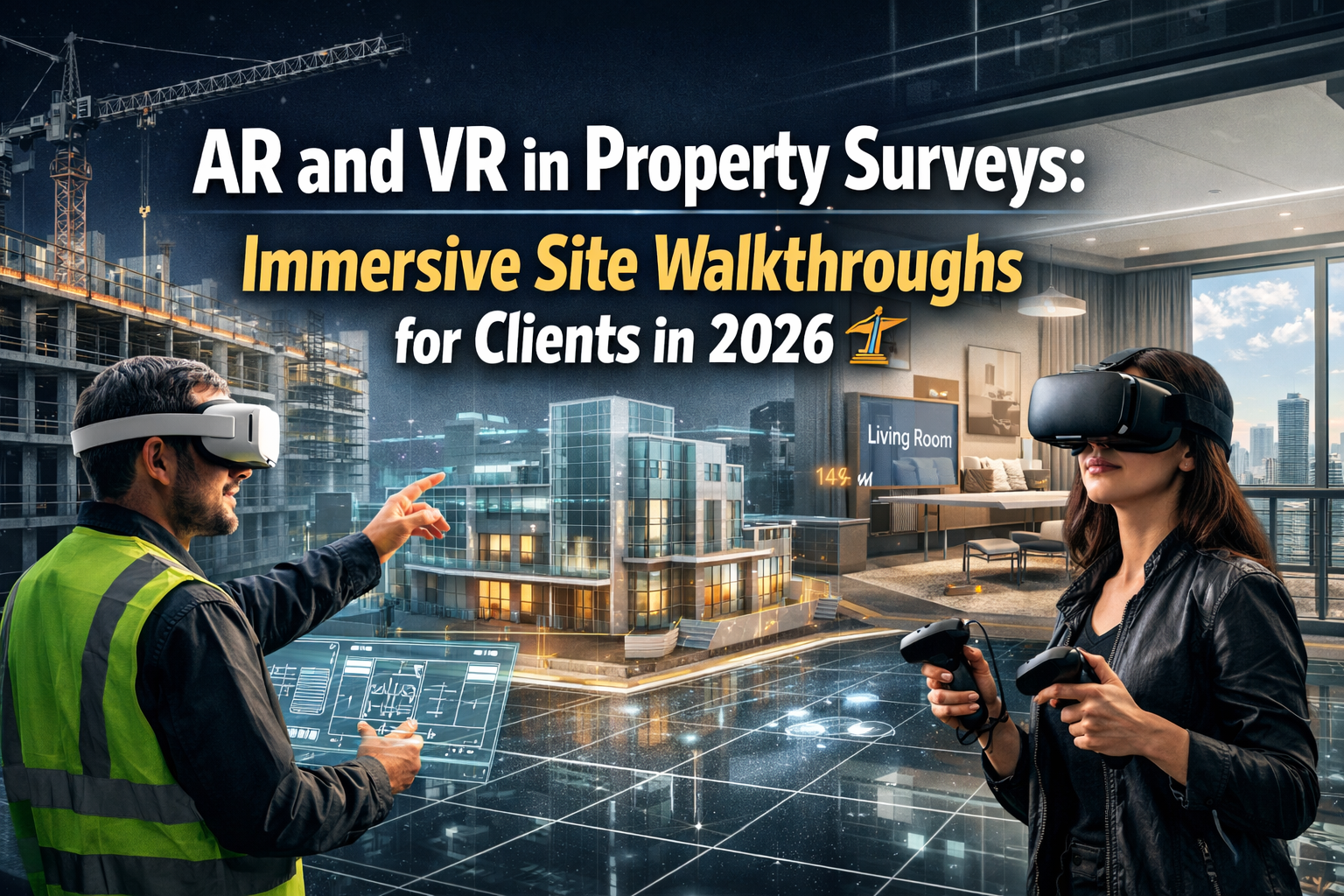
Imagine standing on an empty plot of land and instantly seeing the completed building rise before your eyes, complete with accurate measurements, material specifications, and structural details—all before a single brick is laid. This isn't science fiction; it's the reality of AR and VR in Property Surveys: Immersive Site Walkthroughs for Clients in 2026. As augmented and virtual reality technologies mature, professional surveyors are revolutionizing how stakeholders interact with survey data, transforming complex technical information into immersive experiences that enhance approvals, reduce costly revisions, and streamline development projects.
The property surveying industry has witnessed a remarkable transformation over the past few years. Traditional survey reports filled with technical jargon and 2D drawings are giving way to interactive 3D environments where clients can literally walk through properties before they exist. This shift represents more than technological novelty—it addresses fundamental challenges in property development, where miscommunication and misunderstanding of survey data have historically led to expensive delays and redesigns.
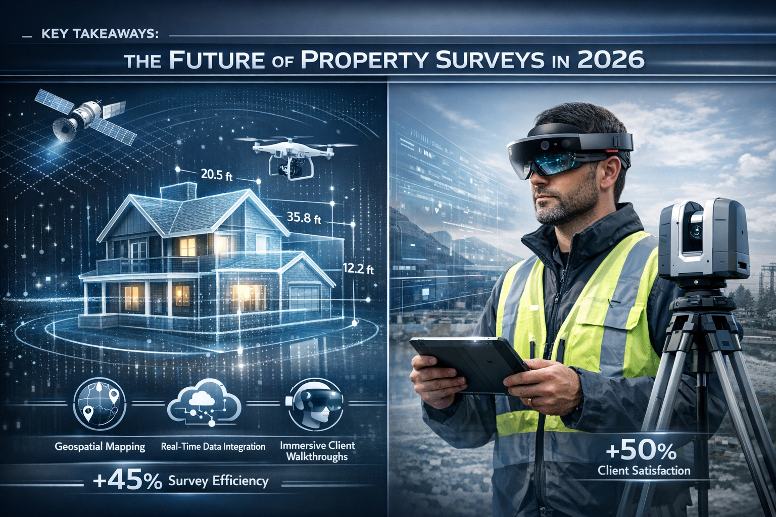
Key Takeaways
- Immersive technology transforms survey data into interactive 3D experiences that stakeholders can explore using VR headsets or AR-enabled smartphones and tablets
- Virtual site walkthroughs eliminate geographic constraints, allowing multiple clients, architects, and developers to simultaneously review properties from anywhere in the world
- AR overlays provide real-time spatial visualization of boundaries, elevations, and proposed modifications directly onto physical sites through mobile devices
- Early stakeholder engagement through immersive surveys significantly reduces revision cycles and accelerates approval processes for development projects
- Professional surveyors require strategic investment in cameras, software platforms, and training to deliver high-quality AR/VR survey experiences that generate measurable ROI
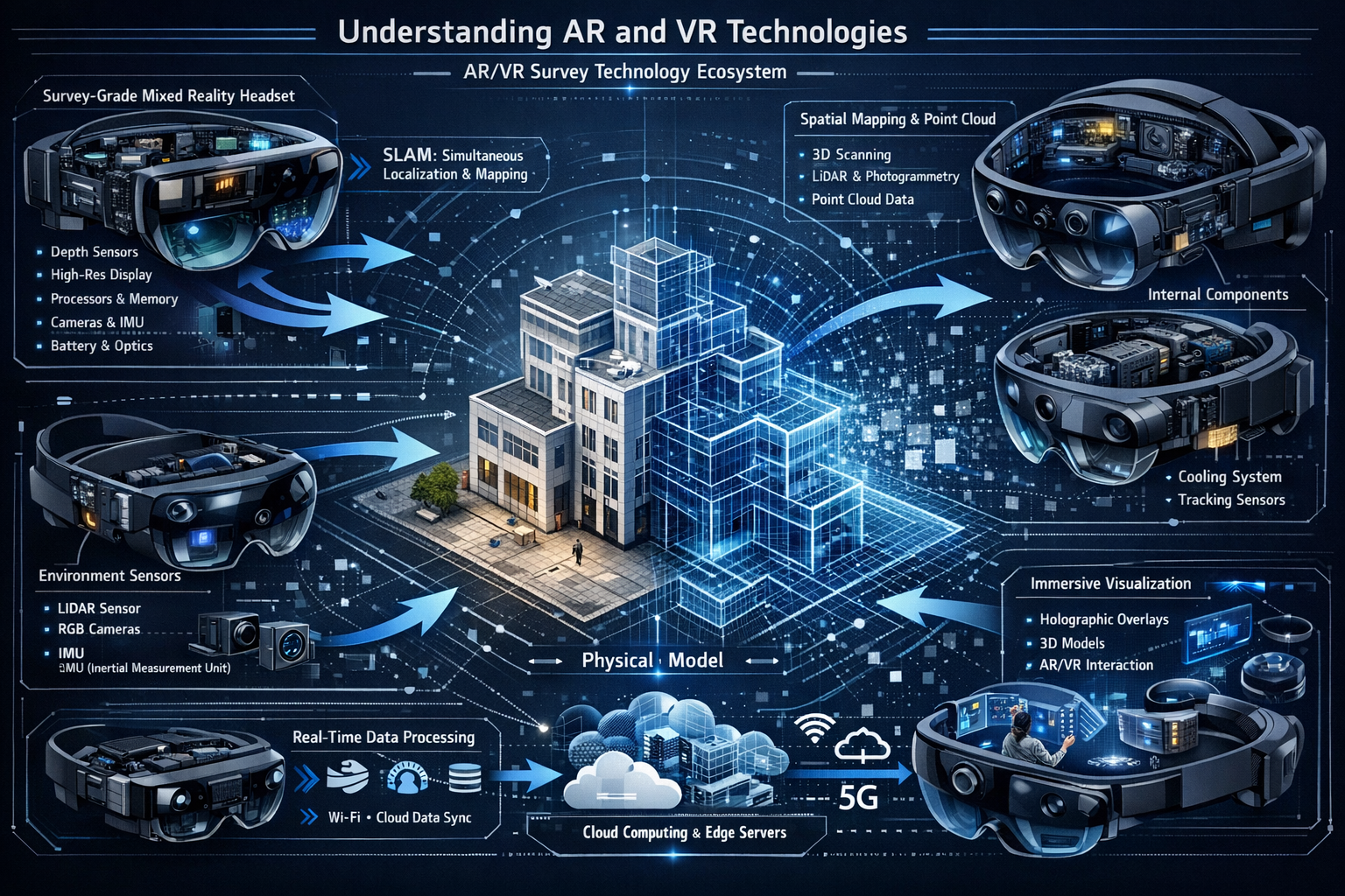
Understanding AR and VR Technologies in Modern Property Surveys
What Makes AR and VR Different?
Virtual Reality (VR) creates completely immersive digital environments that replace the physical world. Users wear specialized headsets that transport them into computer-generated spaces where they can examine properties from every angle, walk through rooms, and interact with architectural elements as if physically present.
Augmented Reality (AR), by contrast, overlays digital information onto the real world. Using smartphones, tablets, or AR glasses, surveyors and clients can view property boundaries, elevation data, and proposed structures superimposed directly onto actual sites. This technology bridges the gap between abstract survey data and tangible reality.[4]
360° Photography represents a hybrid approach, capturing panoramic images that viewers can explore interactively. While less immersive than full VR, 360° tours require less specialized equipment and work seamlessly across standard devices.[1]
The Technology Stack Behind Immersive Surveys
Professional implementation of AR and VR in property surveys requires several integrated components:
| Technology Component | Purpose | Professional Application |
|---|---|---|
| 3D Scanning Equipment | Captures precise spatial data | LiDAR scanners, photogrammetry cameras, drone-mounted sensors |
| Processing Software | Converts raw data into 3D models | Point cloud processing, mesh generation, texture mapping |
| AR/VR Platforms | Delivers immersive experiences | Matterport, Unity-based applications, custom survey tools |
| Mobile Devices | Client-side viewing | Smartphones, tablets, VR headsets, AR glasses |
| Cloud Hosting | Stores and distributes models | Secure servers with bandwidth for large 3D files |
The market leader Matterport frequently tops industry lists for creating detailed "digital twins"—accurate 3D representations of properties that preserve precise measurements and spatial relationships.[1] For chartered surveyors, these platforms transform traditional survey deliverables into interactive experiences.
How Survey Data Becomes Immersive Experiences
The process of creating AR and VR property surveys follows a systematic workflow:
- Site Capture: Surveyors visit properties with specialized cameras or drone survey equipment to capture comprehensive spatial data
- Data Processing: Raw images and measurements are processed into cohesive 3D models with accurate geometry
- Enhancement: Survey information (boundaries, elevations, defects) is integrated as interactive overlays
- Platform Deployment: Finished models are uploaded to viewing platforms accessible via web browsers or dedicated apps
- Client Access: Stakeholders receive secure links to explore properties using their preferred devices
This workflow dramatically improves upon traditional methods where clients struggled to interpret technical drawings and written reports. Instead of imagining spatial relationships, they experience them directly.
AR and VR in Property Surveys: Immersive Site Walkthroughs Transform Client Engagement
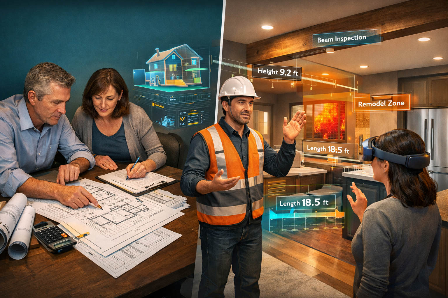
The Client Experience Revolution
The introduction of immersive technology fundamentally changes how clients interact with survey information. Traditional structural surveys delivered thick reports that required significant technical knowledge to interpret. AR and VR eliminate this barrier by presenting information intuitively.
For property buyers, virtual tours provide three documented benefits:
- ⏰ Time savings: Clients can pre-screen multiple properties without physical visits, focusing in-person viewings only on serious contenders
- 🎯 Increased confidence: Walking through properties virtually before purchase reduces uncertainty and buyer's remorse
- 📊 Better spatial understanding: Immersive experiences help clients accurately assess room sizes, layouts, and flow—aspects difficult to judge from photographs[1]
For property sellers and developers, the advantages are equally compelling:
- 🌍 Expanded reach: Virtual tours attract international buyers and investors who cannot easily visit physical sites
- ✅ Qualified visitors: Clients who request in-person viewings after virtual tours are typically more serious and informed
- 📈 Competitive differentiation: Properties with immersive tours stand out in crowded markets, appearing more professional and transparent[1]
Simultaneous Multi-Client Presentations
One of the most powerful applications of VR in property surveys is the ability to conduct simultaneous presentations to multiple stakeholders regardless of location. Virtual reality applications enable surveyors to present properties to hundreds of clients at once, eliminating geographic and scheduling constraints that plague traditional site visits.[3]
Consider a development project requiring approval from planning committees, investors, neighboring property owners, and local community groups. Coordinating site visits for all parties would be logistically complex and time-consuming. With VR, all stakeholders can explore the same survey data simultaneously from their respective locations, asking questions and providing feedback in real-time.
This capability proves particularly valuable for:
- International investors evaluating UK properties from overseas
- Planning authorities reviewing multiple development proposals efficiently
- Heritage organizations assessing impact on protected buildings
- Community consultation processes requiring broad stakeholder input
Pre-Construction Visualization for Development Projects
Virtual reality transforms how developers market and refine properties still under construction. By overlaying final 3D architectural renderings onto survey data of partially completed buildings, VR helps stakeholders visualize finished projects long before completion.[3]
This application addresses a critical challenge in property development: selling or securing financing for projects that exist only as blueprints. Investors and buyers struggle to envision completed spaces from 2D plans, leading to hesitation and delayed commitments.
With AR and VR in property surveys, developers can:
- Show prospective buyers exactly how apartments will look and feel
- Demonstrate how proposed modifications fit within existing structures
- Identify design conflicts before construction begins
- Secure pre-sales and financing with compelling visual presentations
Professional surveyors conducting commercial building surveys increasingly incorporate these visualization capabilities, providing clients with comprehensive understanding of both current conditions and future possibilities.
Practical Implementation for Professional Surveyors
Equipment and Software Requirements
Implementing AR and VR capabilities requires strategic investment in technology infrastructure. While costs have decreased significantly, professional-grade equipment remains essential for delivering accurate, reliable survey experiences.
Essential Hardware:
- 📷 360° Cameras: Entry-level options start around £300-500, while professional models (Matterport Pro2, Ricoh Theta Z1) range from £2,000-4,000
- 🚁 Drone Equipment: For roof surveys and large sites, drones with 4K cameras cost £800-3,000
- 📱 Mobile Devices: Tablets and smartphones for field data collection and client demonstrations
- 🥽 VR Headsets: Optional but valuable for client presentations; standalone units like Meta Quest 3 cost around £500
Software Platforms:
- Matterport: Industry-leading platform for creating 3D digital twins, subscription-based pricing
- Cupix: Specialized for construction documentation and progress tracking
- IrisVR: Designed for architectural visualization and stakeholder collaboration
- Custom Solutions: Bespoke applications built on Unity or Unreal Engine for specialized survey needs
The return on investment typically manifests through faster sales cycles, reduced wasted site visits, and enhanced professional reputation. Properties marketed with immersive tours sell faster and often command premium prices due to increased buyer confidence.[1]
Integration with Traditional Survey Services
AR and VR technologies complement rather than replace traditional surveying methods. The most effective approach integrates immersive experiences with established survey deliverables.
For example, a comprehensive boundary survey might include:
- Traditional written report with legal descriptions and measurements
- 2D survey drawings showing precise boundary locations
- AR overlay allowing clients to view boundaries on-site using smartphones
- 3D model showing boundary relationships to existing structures
Similarly, dilapidation surveys benefit from immersive documentation that records property conditions in unprecedented detail. Instead of describing defects in text, surveyors can create annotated 3D models where clients click on specific areas to view photographs, measurements, and repair recommendations.
Training and Skill Development
Successful implementation requires surveyors to develop new competencies beyond traditional measurement and reporting skills:
- 3D Capture Techniques: Proper camera positioning, lighting management, and scan planning to ensure complete coverage
- Software Proficiency: Mastering processing applications to create accurate, visually appealing models
- Client Communication: Explaining immersive technology benefits and guiding stakeholders through virtual experiences
- Data Management: Organizing and securing large 3D files while maintaining client confidentiality
- Quality Control: Verifying that 3D models accurately represent measured conditions
Professional organizations increasingly offer training programs specifically focused on immersive survey technologies. Chartered surveyors who invest in these skills position themselves competitively as client expectations evolve.
AR and VR Applications Across Survey Specializations
Residential Property Surveys
For residential work, AR and VR enhance every stage of the property transaction process. Buyers can virtually tour properties before scheduling physical viewings, saving time and focusing attention on genuinely suitable options.
When conducting specific defect reports, surveyors can create annotated 3D models that clearly show problem areas in spatial context. Instead of describing a crack's location in text, clients see exactly where it appears and understand its relationship to structural elements.
Augmented reality proves particularly valuable for:
- Visualizing proposed extensions or modifications before planning applications
- Showing how furniture arrangements will work in specific rooms
- Demonstrating the impact of different color schemes and finishes
- Identifying optimal locations for fixtures and fittings
Prospective buyers can use smartphones to overlay digital information onto physical spaces, visualizing furniture arrangements, color schemes, and potential renovations before committing to purchase.[2]
Commercial and Industrial Applications
Commercial property surveys benefit enormously from immersive technology. Large warehouses, office complexes, and retail spaces are difficult to fully appreciate from photographs or floor plans alone.
For commercial dilapidation surveys, 3D documentation provides irrefutable evidence of property conditions at lease commencement or termination. Landlords and tenants can review the same immersive model, reducing disputes about responsibility for repairs.
Commercial applications include:
- 🏢 Lease negotiations: Virtual tours help prospective tenants evaluate spaces without disrupting current occupants
- 📋 Facility management: 3D models serve as living documents updated to reflect modifications and maintenance
- 🔧 Renovation planning: Contractors can virtually measure spaces and plan work without repeated site visits
- 💼 Investment analysis: Remote investors can thoroughly evaluate properties before acquisition
Development and Planning Applications
AR and VR technologies revolutionize how development proposals are presented to planning authorities and community stakeholders. Traditional planning applications rely on technical drawings that non-specialists struggle to interpret, leading to misunderstandings and objections.
Immersive presentations allow planning committees to:
- Experience proposed developments from street level and neighboring properties
- Assess visual impact on surrounding areas and protected views
- Understand scale and massing in context of existing buildings
- Evaluate design quality and architectural merit comprehensively
This enhanced communication significantly improves approval rates and reduces revision cycles. Planning authorities appreciate applications that demonstrate thorough consideration of contextual impacts, while developers benefit from faster, more predictable approval processes.
For projects requiring expert witness reports, immersive documentation provides compelling evidence that courts and tribunals can easily understand, strengthening technical arguments with visual clarity.
Heritage and Conservation Work
Surveying historic buildings presents unique challenges where AR and VR offer particular advantages. Creating detailed 3D records of heritage properties serves multiple purposes:
- Documentation: Preserving precise records of buildings in current condition
- Restoration Planning: Visualizing proposed conservation work before implementation
- Public Engagement: Allowing virtual access to buildings closed to physical visitors
- Research: Enabling scholars to study architectural details remotely
When combined with traditional conservation survey methods, immersive technology creates comprehensive archives that support both preservation and appropriate development of historic properties.
Overcoming Implementation Challenges
Technical Barriers and Solutions
While AR and VR technologies have matured significantly, professional implementation still faces several technical challenges:
Challenge: Large File Sizes
3D models can exceed several gigabytes, creating storage and bandwidth issues.
✅ Solution: Cloud-based hosting platforms compress files for efficient delivery while maintaining visual quality. Progressive loading techniques display lower-resolution previews while detailed models load in background.
Challenge: Device Compatibility
Clients use various devices with different capabilities.
✅ Solution: Web-based platforms that work across smartphones, tablets, and computers without requiring specialized apps. Provide VR headset options for clients who want fully immersive experiences while ensuring basic functionality on standard devices.
Challenge: Accuracy Verification
Ensuring 3D models accurately represent measured conditions.
✅ Solution: Integrate traditional survey measurements into 3D environments as verification checkpoints. Use professional-grade capture equipment calibrated to surveying standards rather than consumer cameras.
Cost-Benefit Analysis
The investment required for professional AR/VR implementation raises legitimate questions about return on investment. High-quality immersive tours require investment in cameras, software, and hosting infrastructure.[1]
Typical Investment Breakdown:
- Initial equipment: £3,000-8,000
- Software subscriptions: £100-300 monthly
- Training and skill development: £1,000-3,000
- Ongoing hosting costs: £50-200 monthly
Measurable Returns:
- ⚡ Faster sales cycles: Properties with virtual tours sell 31% faster on average
- 🎯 Reduced wasted visits: 40-60% reduction in unqualified site visits
- 💰 Premium pricing: Enhanced presentation supports 2-5% higher asking prices
- 📈 Competitive advantage: Differentiation in crowded markets attracts quality clients
- 🌟 Enhanced reputation: Early adopters establish themselves as industry leaders
For established surveying practices, the investment typically pays for itself within 12-18 months through increased efficiency and enhanced service offerings. When determining what survey you need, clients increasingly favor firms offering immersive documentation.
Privacy and Security Considerations
Creating detailed 3D models of properties raises important privacy and security questions. Surveyors must implement robust protocols to protect client confidentiality:
- 🔒 Secure hosting: Use platforms with encryption and access controls
- 👤 Permission management: Require authentication before allowing access to sensitive properties
- ⏱️ Time-limited access: Provide temporary links that expire after viewing periods
- 📝 Data retention policies: Clear agreements about how long models are stored and when they're deleted
- 🚫 Redaction capabilities: Ability to blur or remove sensitive information from models
Professional indemnity insurance should specifically cover digital survey deliverables, and client agreements should clearly define ownership and usage rights for 3D models.
Future Developments in AR and VR Property Surveys
Emerging Technologies on the Horizon
The rapid evolution of AR and VR technologies promises even more powerful capabilities for property surveyors in the coming years.
Mobile AR Without Additional Hardware
Future developments include mobile AR applications that require no specialized equipment beyond standard smartphones, making immersive surveys accessible to all clients.[1] Advanced computer vision and machine learning will enable phones to accurately map spaces and overlay survey data in real-time.
Artificial Intelligence Integration
AI algorithms will automatically analyze 3D survey models to:
- Identify potential defects and structural issues
- Generate highlight reels showcasing key property features for social media marketing
- Provide automated measurements and area calculations
- Suggest optimal furniture layouts and space utilization
These AI-powered capabilities will dramatically reduce the time required to process and present survey data while improving consistency and accuracy.[1]
Live Virtual Open Houses
Real-time virtual events will enable surveyors and agents to guide multiple clients through properties simultaneously, answering questions and highlighting features as groups explore together. This combines the efficiency of virtual tours with the personal interaction of traditional viewings.[1]
Haptic Feedback Integration
Advanced VR systems incorporating haptic gloves and suits will allow users to "feel" virtual surfaces, adding tactile dimension to immersive property experiences. While currently expensive, these technologies will become more accessible as the market matures.
Integration with Building Information Modeling (BIM)
The convergence of AR/VR survey technologies with Building Information Modeling creates powerful opportunities for construction and facility management. Survey data captured in 3D becomes the foundation for comprehensive BIM models that track properties throughout their lifecycles.
This integration enables:
- As-built verification: Comparing constructed buildings against design specifications
- Maintenance planning: Accessing equipment specifications and service histories through AR overlays
- Renovation design: Importing existing conditions into design software for accurate modification planning
- Energy modeling: Analyzing thermal performance and identifying efficiency improvements
For surveyors, BIM integration represents an opportunity to provide ongoing value beyond initial surveys, establishing long-term client relationships through facility management services.
Regulatory and Professional Standards Evolution
As AR and VR become standard survey deliverables, professional bodies and regulatory authorities are developing guidelines and standards to ensure quality and consistency.
Expected developments include:
- Accuracy standards: Defined tolerances for 3D models used in professional surveys
- Metadata requirements: Standardized information that must accompany immersive models
- Accessibility guidelines: Ensuring virtual tours work for users with disabilities
- Certification programs: Professional qualifications specifically for immersive survey technologies
Surveyors who actively participate in developing these standards position themselves as industry leaders while ensuring their practices align with emerging requirements.
Best Practices for Implementing AR and VR in Survey Practice
Client Communication Strategies
Successfully introducing immersive survey technologies requires clear communication about benefits and proper expectations management.
Effective Communication Approaches:
- Demonstrate value early: Show sample virtual tours during initial client consultations
- Explain limitations: Be clear that 3D models complement rather than replace traditional reports
- Provide guidance: Offer simple instructions for accessing and navigating virtual tours
- Gather feedback: Regularly ask clients about their experience to refine delivery methods
- Highlight applications: Explain specific ways immersive data benefits their project
Many clients, particularly older demographics, may feel intimidated by new technologies. Patient education and user-friendly interfaces help overcome resistance and build confidence.
Quality Control Procedures
Maintaining professional standards requires rigorous quality control throughout the immersive survey process:
✅ Pre-Capture Planning
- Site reconnaissance to identify optimal scanning positions
- Lighting assessment and supplementary illumination planning
- Identification of areas requiring special attention or multiple angles
✅ Capture Execution
- Systematic coverage ensuring no gaps in 3D model
- Verification scans to confirm complete data collection
- Field notes documenting any anomalies or special conditions
✅ Processing Review
- Verification that measurements match field observations
- Visual inspection for artifacts, distortions, or missing data
- Comparison against traditional survey measurements
✅ Client Delivery
- Testing links and access controls before client distribution
- Providing clear instructions and support contact information
- Following up to ensure successful viewing and understanding
Building a Competitive Service Offering
Surveyors implementing AR and VR technologies should consider how immersive capabilities enhance their overall service portfolio:
Tiered Service Levels:
- Standard: Traditional written report with photographs
- Enhanced: Report plus 360° photography and floor plans
- Premium: Comprehensive package including full 3D model, AR overlays, and VR-ready deliverables
This approach allows clients to select service levels matching their needs and budgets while positioning immersive surveys as premium offerings that command appropriate fees.
Specialized Applications:
Develop expertise in specific niches where AR/VR provides particular value:
- Pre-acquisition surveys for investment properties
- Development feasibility studies with visualization
- Heritage documentation and conservation planning
- Dispute resolution with detailed condition records
Specialization enables premium pricing while building reputation as the go-to expert for specific survey applications.
Real-World Success Stories and Case Studies
Residential Development Approval
A London-based developer faced community opposition to a proposed residential development in a conservation area. Traditional planning drawings failed to convey how the new buildings would integrate with existing Victorian architecture.
By creating an immersive AR presentation, the developer allowed planning committee members and local residents to experience the proposal from multiple vantage points, including views from neighboring properties and public spaces. The visualization demonstrated that sight lines to protected buildings would be preserved and that the contemporary design complemented rather than competed with historic structures.
The planning application was approved with minimal modifications, saving an estimated six months compared to the typical revision and resubmission cycle. The developer attributed success directly to the clarity and accessibility of the immersive presentation.
Commercial Lease Negotiation
A multinational corporation sought to lease 50,000 square feet of office space across three London buildings without sending executives for in-person viewings. Traditional photographs and floor plans proved insufficient for making a multi-million-pound commitment.
The property surveyor created comprehensive 3D models of all three options, annotated with measurements, ceiling heights, and technical specifications. Decision-makers in New York, Singapore, and Frankfurt simultaneously explored the spaces using VR headsets during a coordinated virtual tour.
Within two weeks, the corporation selected their preferred space and negotiated lease terms—a process that typically requires months of international travel and scheduling coordination. The surveyor's immersive presentation was cited as the decisive factor enabling rapid, confident decision-making.
Heritage Building Documentation
A Grade I listed country house required comprehensive documentation before major conservation work could commence. Traditional survey methods would capture measurements and conditions but struggle to convey the building's architectural significance and spatial complexity.
The surveying team created a detailed 3D model that served multiple purposes: providing precise measurements for conservation architects, creating a permanent record of pre-restoration conditions, and enabling virtual access for researchers and the public unable to visit the fragile building.
The immersive documentation revealed previously unnoticed architectural details that influenced restoration approaches, while the public-facing virtual tour generated significant media coverage and donor support for the conservation project.
Conclusion: Embracing the Future of Property Surveys
AR and VR in Property Surveys: Immersive Site Walkthroughs for Clients in 2026 represents far more than technological novelty—it's a fundamental transformation in how survey information is captured, processed, and communicated. As client expectations evolve and competition intensifies, professional surveyors who embrace immersive technologies position themselves for sustained success.
The evidence is compelling: virtual tours are now expected features in property marketing, with major platforms prioritizing immersive capabilities.[1] Market consolidation, including CoStar Group's acquisition of Matterport, signals that industry leaders recognize immersive technology as essential infrastructure rather than optional enhancement.[1]
For surveyors serving architects, developers, and property investors, the practical benefits are clear. Augmented and virtual reality overlays transform abstract survey data into experiences stakeholders can walk through and understand intuitively. This enhanced communication accelerates approvals, reduces revision cycles, and ultimately delivers better outcomes for all parties.
Actionable Next Steps for Professional Surveyors
Immediate Actions (Next 30 Days):
- 📊 Assess current capabilities: Evaluate which survey services would benefit most from immersive enhancement
- 🎯 Research platforms: Compare Matterport, Cupix, and other solutions to identify best fit for your practice
- 💡 Pilot project: Select one upcoming survey to test immersive documentation on a small scale
- 📚 Skill development: Enroll in training programs focused on 3D capture and processing techniques
Medium-Term Goals (3-6 Months):
- 💰 Investment planning: Develop business case and budget for equipment and software
- 🤝 Client education: Create materials explaining immersive survey benefits and applications
- 🔧 Workflow integration: Establish procedures for incorporating 3D capture into existing survey processes
- 📈 Marketing strategy: Promote new capabilities through website updates, case studies, and client communications
Long-Term Vision (12+ Months):
- 🏆 Competitive differentiation: Establish reputation as immersive survey specialist in your market
- 🌐 Service expansion: Develop specialized offerings leveraging AR/VR for specific property types or applications
- 👥 Team development: Build in-house expertise through ongoing training and experience
- 🔮 Technology evolution: Stay current with emerging capabilities and industry standards
The future of property surveying is immersive, interactive, and increasingly accessible. Surveyors who invest in these capabilities today will lead the industry tomorrow, delivering exceptional value to clients while building sustainable competitive advantages.
Whether conducting building surveys, valuations, or specialized assessments, the integration of AR and VR technologies enhances every aspect of professional practice. The question is no longer whether to adopt immersive survey methods, but how quickly to implement them effectively.
By transforming complex technical data into experiences stakeholders can explore and understand, AR and VR in Property Surveys: Immersive Site Walkthroughs for Clients in 2026 empowers surveyors to communicate more effectively, serve clients more comprehensively, and navigate the evolving property landscape with confidence and capability.
References
[1] Ar And Vr Trends In Real Estate Apps – https://www.wizwebitsolutions.com/tech-pulse/ar-and-vr-trends-in-real-estate-apps
[2] Augmented Virtual Reality Real Estate – https://www.nar.realtor/augmented-virtual-reality-real-estate
[3] Impact Of Virtual Reality On The Real Estate Industry – https://usmsystems.com/impact-of-virtual-reality-on-the-real-estate-industry/
[4] Ar And Vr – https://www.mysurveyingdirect.com/blogs/surveying/ar-and-vr