The property and construction landscape is experiencing a seismic shift. As surveying technology evolves at breakneck speed, professionals who fail to adapt risk being left behind in an increasingly competitive marketplace. Trimble's 2026 Surveying Trends: Six Strategies Every Property Professional Must Adopt represents more than just technological advancement—it signals a fundamental transformation in how property professionals approach their craft.
In November 2025, Trimble's Dimensions user conference surveyed 1,800 civil, general, and specialty contractors to identify the technology priorities and challenges shaping 2026.[1] The findings reveal a clear consensus: integration, data sharing, and overcoming labor challenges are the areas where technology initiatives can deliver the biggest return on investment this year.[1] For property professionals—from chartered surveyors to construction managers—understanding and implementing these strategies is no longer optional.
This comprehensive guide explores Trimble's 2026 Surveying Trends: Six Strategies Every Property Professional Must Adopt, providing actionable frameworks for applying AI workflows, machine control, and reality capture technologies in property transactions and development projects.
Key Takeaways
- 🤖 AI agents are moving from experimental pilots to production workflows, streamlining design processes, orchestrating schedules, and managing resources across connected ecosystems
- 📊 Reality capture technology is becoming democratized, making millimeter-accurate 3D data collection accessible to surveying firms of all sizes through mobile phones and robust mapping systems
- 🔗 Interoperability between construction technology platforms is accelerating, reducing data silos and enabling seamless information sharing regardless of software vendors
- 🎯 Machine control systems are becoming standard equipment rather than optional technology, requiring surveyors to provide increasingly precise spatial data
- 👥 Workforce training and technology integration represent the twin priorities for maximizing return on investment from advanced surveying tools
Understanding the Technology Landscape Driving Trimble's 2026 Surveying Trends
The Data Siloing Crisis in Modern Construction
Many construction and property development projects currently face significant inefficiencies from diverse teams using incompatible technology stacks that don't share data effectively.[1] This fragmentation leads to errors, project delays, and substantial lost revenue. When structural survey teams can't seamlessly share findings with architects, or when as-built data doesn't integrate with design models, the entire project timeline suffers.
The financial impact is staggering. Industry research indicates that poor data management and communication failures account for billions in annual losses across the construction sector. For individual property professionals, this translates to:
- Duplicated effort as teams re-collect information already gathered by others
- Increased liability exposure from miscommunication and data inconsistencies
- Client dissatisfaction due to preventable delays and cost overruns
- Competitive disadvantage against firms leveraging integrated technology ecosystems
What Industry Leaders Prioritize for Technology Investment
When asked to identify technology investments they would prioritize if costs were no object, industry leaders consistently highlighted two critical areas:[1]
- Leveraging artificial intelligence to augment human capabilities and automate repetitive workflows
- Investing in advanced reality capture and precision positioning technologies for millimeter-level accuracy onsite
These priorities reflect a fundamental understanding: the future belongs to firms that can collect better data faster and extract actionable insights more efficiently. For property professionals conducting homebuyer reports or commercial building surveys, this means adopting tools that deliver superior accuracy while reducing time investment.
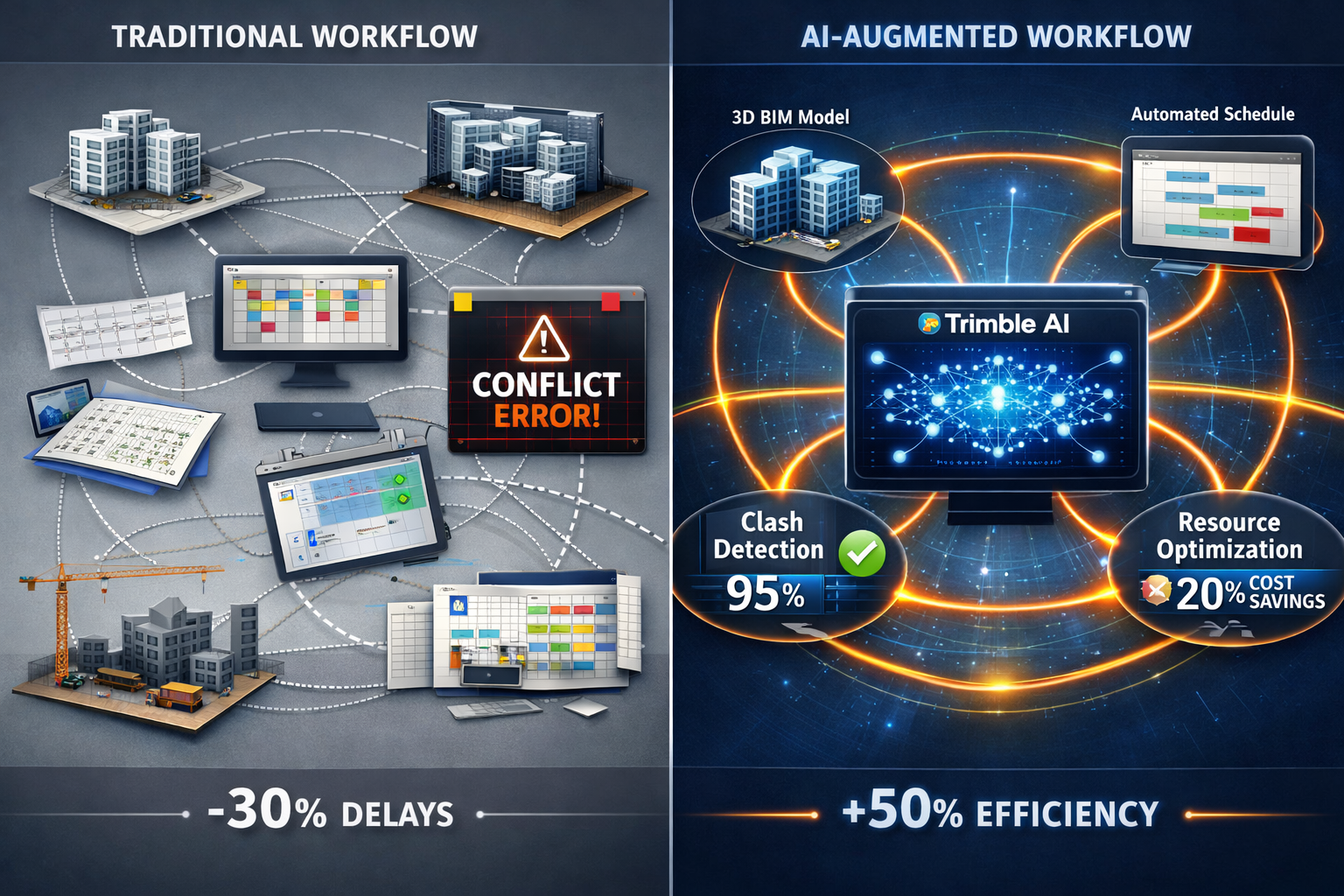
Strategy #1: Implement AI Agents Across Design, Engineering, and Construction Workflows
From Isolated Pilots to Production-Ready Systems
Aviad Almagor, vice president of technology innovation at Trimble, predicts that isolated AI pilots will move beyond experimentation in 2026 to impact real-world workflows.[1] Networks of AI agents are expected to operate across design, engineering, and construction in connected ecosystems, fundamentally changing how property professionals work.
"AI agents are no longer confined to research labs or limited pilot programs. In 2026, we're seeing these systems deployed in production environments where they're streamlining design processes, orchestrating schedules, resolving conflicts, tracking progress, and managing resources." — Aviad Almagor, VP of Technology Innovation, Trimble[1]
For property professionals, this transformation manifests in several practical applications:
Automated Conflict Detection: AI systems can analyze building survey data and identify potential structural conflicts before construction begins, flagging issues that might escape human review.
Intelligent Scheduling: AI agents can optimize survey schedules based on weather patterns, site access constraints, and equipment availability, maximizing productivity while minimizing downtime.
Predictive Maintenance: Machine learning algorithms can analyze historical equipment performance data to predict maintenance needs, preventing costly equipment failures during critical survey operations.
Actionable Framework for AI Adoption
Phase 1: Assessment (Weeks 1-2)
- Identify repetitive tasks consuming significant staff time
- Evaluate current technology stack for AI integration capabilities
- Establish baseline metrics for efficiency and accuracy
Phase 2: Pilot Implementation (Weeks 3-8)
- Select one high-impact workflow for initial AI deployment
- Partner with technology vendors offering proven AI solutions
- Train core team members on AI tool operation and interpretation
Phase 3: Evaluation and Scaling (Weeks 9-12)
- Measure performance improvements against baseline metrics
- Gather user feedback and identify optimization opportunities
- Develop rollout plan for additional workflows and team members
Phase 4: Full Integration (Months 4-6)
- Expand AI tools across all relevant workflows
- Establish ongoing training programs for new hires
- Create feedback loops for continuous improvement
Strategy #2: Democratize Reality Capture Technology Across Your Organization
Making Advanced Technology Accessible to All Team Members
Reality capture technology will become more accessible to surveying firms of all sizes in 2026 as user-friendly tools and broader platform support expand adoption.[2] New tools enable comprehensive data collection and capture from mobile phones and robust mobile mapping systems, eliminating the traditional barrier of expensive specialized equipment.
This democratization represents a paradigm shift for property professionals. Previously, reality capture required significant capital investment in laser scanners, photogrammetry equipment, and specialized software. Today's solutions leverage smartphone cameras, cloud processing, and intuitive interfaces to deliver comparable results at a fraction of the cost.
The Spectrum of Reality Capture Solutions
| Technology Level | Equipment Required | Typical Accuracy | Best Applications | Investment Range |
|---|---|---|---|---|
| Entry Level | Smartphone with photogrammetry app | ±10-50mm | Initial site documentation, client presentations | £0-£500 |
| Mid-Range | Tablet with LiDAR scanner | ±5-10mm | Drone roof surveys, interior measurements | £1,000-£5,000 |
| Professional | Dedicated mobile mapping system | ±2-5mm | As-built verification, boundary surveys | £10,000-£50,000 |
| Enterprise | Integrated terrestrial laser scanning | ±1-2mm | Large infrastructure projects, precision engineering | £50,000+ |
Implementation Strategy for Reality Capture Adoption
Step 1: Start with Existing Devices
Begin by exploring reality capture apps compatible with smartphones and tablets already in your inventory. Many professional-grade applications now offer free trials or affordable subscriptions, allowing teams to experiment without significant financial commitment.
Step 2: Establish Data Management Protocols
Reality capture generates massive datasets. Before widespread adoption, establish clear protocols for:
- File naming conventions and metadata standards
- Cloud storage organization and access permissions
- Data retention policies and archival procedures
- Quality control checkpoints and validation processes
Step 3: Train Teams on Data Collection Best Practices
Effective reality capture requires understanding fundamental principles:
- Optimal lighting conditions for photogrammetry
- Proper overlap percentages for point cloud generation
- Target placement for registration accuracy
- Movement speed and stability for mobile mapping
Step 4: Integrate Captured Data into Deliverables
The true value of reality capture emerges when data enhances client deliverables. Consider incorporating:
- Interactive 3D models in survey reports
- Accurate measurements extracted from point clouds
- Before-and-after comparisons for renovation projects
- Virtual site tours for remote stakeholders
Strategy #3: Embrace Machine Control and Autonomous Systems as Standard Infrastructure
The Evolution from Optional to Essential
The construction industry's journey toward autonomy continues as an incremental process rather than a dramatic revolution.[2] Machine control systems are becoming standard equipment on modern earthmoving projects, no longer optional technology but essential infrastructure that contractors expect as baseline capability.
For surveyors and property professionals, this evolution creates both opportunities and obligations. As machines rely increasingly on precise spatial information to operate efficiently and safely, the role of providing accurate, timely data becomes mission-critical.[2]
The Surveyor's Expanding Responsibility in Automated Construction
Site Control Work: Establishing control networks that autonomous machines can reference requires greater precision and redundancy than traditional surveying. Control points must be:
- Positioned for optimal machine visibility and GPS reception
- Protected from disturbance throughout project duration
- Verified regularly to ensure continued accuracy
- Documented with comprehensive metadata
Digital Terrain Models: Creating DTMs for machine control demands understanding how equipment interprets and executes design intent. Surveyors must:
- Model surfaces at appropriate resolution for machine capabilities
- Include transition zones and blending areas
- Validate models against design specifications
- Provide updates as conditions change
As-Built Verification: Autonomous systems work to tolerances measured in millimeters, requiring corresponding precision in verification:
- Real-time quality control during construction operations
- Immediate feedback loops when deviations occur
- Comprehensive documentation of achieved grades
- Integration with project management systems
Practical Implementation for Property Professionals
For property professionals working on development projects, supporting machine control systems requires strategic preparation:
Pre-Construction Phase:
- Collaborate with contractors to understand machine control requirements
- Establish control networks before mobilization
- Validate design models for machine compatibility
- Develop quality control protocols
During Construction:
- Provide rapid turnaround on as-built surveys
- Maintain control network integrity
- Support troubleshooting when machine guidance issues arise
- Document progress for stakeholder reporting
Post-Construction:
- Deliver comprehensive as-built documentation
- Verify final grades against design specifications
- Archive data for future reference and warranty claims
- Capture lessons learned for future projects
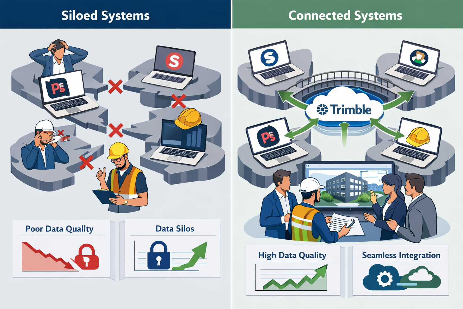
Strategy #4: Accelerate Interoperability Between Technology Platforms

Breaking Down Data Silos Through Enhanced Integration
Construction technology vendors, including Trimble, are accelerating efforts to enhance interoperability, delivering greater value to contractors through workflows and integrations between construction technology ecosystems.[2] This enables data sharing regardless of software platforms used, fundamentally changing expectations for how surveying data integrates into broader project workflows.
The shift toward open data standards and API-driven integrations addresses one of the construction industry's most persistent challenges: information locked in proprietary formats that can't flow freely between stakeholders. For property professionals, improved interoperability means:
✅ Reduced manual data re-entry and associated error risks
✅ Faster turnaround times from field collection to client deliverables
✅ Expanded potential client base by supporting diverse technology stacks
✅ Enhanced collaboration with architects, engineers, and contractors
✅ Future-proofing against vendor lock-in and technology obsolescence
Rising Expectations for Data Quality and Formatting
As systems connect more easily, clients increasingly expect survey data that integrates seamlessly with their workflows.[2] Improved interoperability reduces friction in data handoffs and expands potential client bases, but also raises expectations for data quality and formatting.
Property professionals must now consider:
Format Flexibility: Delivering data in multiple formats (IFC, LandXML, DWG, RVT, etc.) based on downstream user requirements rather than defaulting to a single standard output.
Metadata Completeness: Including comprehensive attribution that enables intelligent filtering, querying, and analysis within various software platforms.
Coordinate System Consistency: Ensuring spatial reference information travels with datasets and transforms correctly across different systems.
Version Control: Maintaining clear lineage as data evolves through design iterations and construction phases.
Building an Interoperability-First Technology Strategy
Audit Current Capabilities:
- Inventory software platforms currently in use
- Identify integration gaps causing manual workarounds
- Evaluate export/import capabilities for each system
- Benchmark against industry standard formats
Prioritize Integration Investments:
- Focus on connections delivering highest time savings
- Consider client technology preferences when selecting tools
- Evaluate cloud-based platforms with built-in integrations
- Budget for API development or middleware solutions
Establish Data Standards:
- Create organizational templates for common deliverables
- Document naming conventions and layer structures
- Define quality control checkpoints for data validation
- Train teams on proper metadata attribution
Monitor Emerging Standards:
- Stay informed about industry initiatives (buildingSMART, OGC)
- Participate in user groups and standards committees
- Test new integration capabilities as vendors release them
- Share feedback with vendors to influence development priorities
Strategy #5: Adopt Visualization-Driven Collaboration Workflows
The Shift from 2D Plans to 3D Model-Based Communication
The shift toward visualization-driven workflows transforms how surveyors' work integrates with the broader project lifecycle.[2] Design conversations increasingly take place directly within 3D models rather than 2D plans, enabling quicker iterations and stronger alignment throughout design and construction.
For property professionals accustomed to traditional plan-based deliverables, this represents a fundamental change in how clients consume and interact with survey information. Static PDF reports and CAD drawings are giving way to interactive 3D environments where stakeholders can:
- Navigate virtually through existing conditions before site visits
- Visualize proposed changes overlaid on accurate as-built data
- Measure and annotate directly within the model environment
- Collaborate remotely with geographically dispersed teams
- Detect conflicts between existing conditions and design intent
Practical Applications for Property Professionals
Pre-Purchase Property Surveys: When conducting building surveys for prospective buyers, 3D visualization transforms how defects and opportunities are communicated:
- Point cloud data showing roof condition and geometry
- Thermal imaging overlays identifying insulation deficiencies
- Moisture mapping integrated with structural models
- Annotated virtual tours highlighting areas of concern
Renovation and Extension Projects: For property owners planning modifications, visualization enables informed decision-making:
- Existing conditions captured as accurate 3D baseline
- Proposed designs superimposed for spatial understanding
- Sight line analysis from neighboring properties
- Solar exposure studies for natural lighting optimization
Party Wall Matters: When documenting conditions for party wall awards, 3D visualization provides irrefutable evidence:
- Complete pre-construction condition documentation
- Precise measurements for settlement monitoring
- Visual comparison capabilities for dispute resolution
- Shareable access for all parties and appointed surveyors
Implementation Roadmap for Visualization Adoption
Month 1-2: Foundation Building
- Select visualization platform compatible with existing workflows
- Create template projects for common survey types
- Develop style guides for consistent presentation
- Train core team on software operation
Month 3-4: Pilot Projects
- Select 3-5 suitable projects for visualization enhancement
- Gather client feedback on value and usability
- Refine templates based on real-world application
- Document time investment versus traditional methods
Month 5-6: Marketing and Expansion
- Showcase visualization capabilities in marketing materials
- Offer visualization as premium service tier
- Expand training to all field and office staff
- Establish pricing models reflecting added value
Month 7-12: Optimization and Innovation
- Integrate client feedback for continuous improvement
- Explore advanced capabilities (VR, AR, real-time collaboration)
- Develop case studies demonstrating ROI
- Position firm as technology leader in local market
Strategy #6: Prioritize Workforce Integration and Continuous Training
Technology Without Training Delivers Limited Value
Contractors surveyed by Trimble confirmed that advanced tools can help them succeed, and that connecting these tools and training the workforce to optimize them are top priorities for 2026 and beyond.[1] This insight applies equally to property professionals: technology investments deliver returns only when teams possess the skills to leverage them effectively.
The surveying profession faces a unique workforce challenge. Experienced professionals bring deep domain expertise but may resist technological change, while younger team members arrive with digital fluency but lack field experience and professional judgment. Bridging this gap requires intentional strategies that honor both perspectives.
Building a Technology-Enabled Learning Culture
Mentorship Programs with Technology Focus:
- Pair experienced surveyors with tech-savvy junior staff
- Create reverse mentoring opportunities where younger professionals teach digital tools
- Establish shared learning objectives that require collaboration
- Document institutional knowledge in accessible digital formats
Structured Training Pathways:
- Develop competency frameworks for each technology platform
- Create progressive certification levels (basic, intermediate, advanced)
- Provide dedicated time for skill development separate from billable work
- Recognize and reward training completion and skill demonstration
Hands-On Learning Opportunities:
- Allocate specific projects for experimenting with new technologies
- Accept that initial implementations may take longer as teams learn
- Celebrate failures as learning opportunities rather than setbacks
- Share successes and lessons learned across the organization
Measuring Training Effectiveness and ROI
Training represents a significant investment of time and resources. Property firms should establish metrics to evaluate effectiveness:
| Metric | Measurement Method | Target Benchmark |
|---|---|---|
| Adoption Rate | Percentage of team using new technology regularly | >80% within 6 months |
| Efficiency Gain | Time comparison for equivalent tasks | 20-30% reduction |
| Error Reduction | Quality control findings and client complaints | 50% fewer issues |
| Client Satisfaction | Survey scores and repeat business rates | >90% satisfaction |
| Revenue Impact | New services offered and premium pricing achieved | 15-25% revenue increase |
Creating Sustainable Training Infrastructure
Internal Champions:
Identify enthusiastic early adopters who can serve as internal resources, reducing dependence on external training providers and creating peer-to-peer learning opportunities.
Documentation Libraries:
Build comprehensive knowledge bases with:
- Step-by-step workflow guides
- Video tutorials for common tasks
- Troubleshooting resources for typical issues
- Best practice examples from completed projects
Vendor Partnerships:
Leverage relationships with technology vendors to access:
- Complimentary training sessions for new purchases
- Beta testing opportunities for upcoming features
- Direct support channels for technical questions
- User community forums and networking events
Continuous Improvement Cycles:
Establish regular review intervals (quarterly or semi-annually) to:
- Assess which technologies are delivering value
- Identify underutilized capabilities requiring additional training
- Gather feedback on training effectiveness
- Adjust strategies based on evolving needs
Integrating Trimble's 2026 Surveying Trends Into Daily Operations
Creating a Comprehensive Technology Adoption Framework
Successfully implementing Trimble's 2026 Surveying Trends: Six Strategies Every Property Professional Must Adopt requires more than understanding individual strategies—it demands a cohesive framework that integrates all six approaches into daily operations.
Assessment Phase (Weeks 1-4):
- Conduct comprehensive technology audit of current capabilities
- Survey team members about pain points and improvement opportunities
- Analyze recent projects to identify efficiency gaps
- Benchmark against competitors and industry leaders
- Establish baseline metrics for comparison
Strategy Development (Weeks 5-8):
- Prioritize strategies based on potential impact and implementation difficulty
- Develop detailed implementation plans with timelines and responsibilities
- Allocate budget for technology acquisition and training
- Identify quick wins that can build momentum
- Establish governance structure for ongoing oversight
Pilot Implementation (Months 3-6):
- Begin with highest-priority strategy on select projects
- Gather detailed feedback from team members and clients
- Document challenges and develop mitigation strategies
- Measure results against established baselines
- Refine approach based on real-world experience
Scaling and Optimization (Months 7-12):
- Expand successful pilots across all relevant projects
- Integrate additional strategies in planned sequence
- Develop standard operating procedures incorporating new technologies
- Continue training and skill development initiatives
- Celebrate successes and share lessons learned
Overcoming Common Implementation Challenges
Challenge: Resistance to Change
Solution: Involve skeptical team members early in selection and testing processes. Their concerns often identify legitimate issues that need addressing, and participation builds ownership.
Challenge: Budget Constraints
Solution: Demonstrate ROI through small-scale pilots before requesting major investments. Many vendors offer trial periods or flexible financing options that reduce upfront costs.
Challenge: Client Unfamiliarity
Solution: Educate clients about technology benefits through case studies and demonstrations. Position advanced capabilities as competitive advantages that deliver superior outcomes.
Challenge: Technology Overwhelm
Solution: Implement incrementally rather than attempting comprehensive transformation simultaneously. Master one strategy before adding another.
Challenge: Data Security Concerns
Solution: Establish robust cybersecurity protocols, conduct vendor security assessments, and maintain compliance with data protection regulations.
Real-World Applications Across Property Professional Specializations
For Residential Surveyors
Professionals conducting homebuyer reports and building surveys can leverage these strategies to:
- Capture comprehensive property conditions using mobile reality capture during initial site visits
- Identify structural issues with AI-assisted defect detection analyzing thermal and visual data
- Deliver interactive 3D reports that help buyers understand property conditions intuitively
- Streamline report production through automated data extraction and template population
- Differentiate services in competitive residential markets through technology leadership
For Commercial Property Professionals
Those specializing in commercial building surveys and dilapidation assessments benefit from:
- Comprehensive as-built documentation supporting lease negotiations and tenant improvements
- Precise measurement of rentable square footage eliminating disputes
- Schedule of condition reports with irrefutable photographic and dimensional evidence
- Progress monitoring for construction projects with automated comparison to design intent
- Enhanced collaboration with architects and contractors through shared 3D environments
For Valuation Specialists
Professionals providing property valuation services can enhance accuracy and defensibility through:
- Objective dimensional data supporting comparable property analysis
- Visual documentation of property condition influencing value conclusions
- Historical data tracking property changes over time for retrospective valuations
- Enhanced credibility with courts and tribunals through technology-supported evidence
- Efficiency gains allowing more thorough analysis within competitive fee structures
For Party Wall Surveyors
Those handling party wall matters and boundary disputes gain significant advantages:
- Indisputable pre-construction records protecting all parties' interests
- Precise monitoring of settlement and movement during adjacent construction
- Clear communication of technical issues to property owners through visualization
- Efficient dispute resolution with objective data rather than conflicting opinions
- Reduced liability exposure through comprehensive documentation practices
The Competitive Advantage of Early Adoption
Market Differentiation Through Technology Leadership
Property professionals who embrace Trimble's 2026 Surveying Trends: Six Strategies Every Property Professional Must Adopt position themselves as industry leaders rather than followers. This differentiation manifests in several valuable ways:
Premium Pricing Justification: Advanced technology enables superior deliverables that command higher fees. Clients willingly pay premiums for:
- Faster turnaround times reducing transaction delays
- Greater accuracy minimizing post-purchase surprises
- Enhanced visualization improving decision-making confidence
- Comprehensive documentation protecting their interests
Expanded Service Offerings: Technology capabilities enable new revenue streams:
- 3D modeling and visualization services
- Ongoing monitoring and condition tracking
- Data analytics and trend identification
- Consulting on technology adoption for clients' projects
Talent Attraction and Retention: Firms investing in cutting-edge technology attract ambitious professionals seeking career development and modern work environments. This creates a virtuous cycle where better talent delivers superior results, attracting more sophisticated clients.
Referral Network Strength: Architects, solicitors, and estate agents preferentially refer clients to surveyors who make their jobs easier through technology-enabled collaboration and communication.
Risk Mitigation Through Technology Investment
Beyond competitive advantages, technology adoption reduces several categories of professional risk:
Professional Indemnity Claims: Comprehensive documentation and objective data collection reduce exposure to negligence claims. When disputes arise, technology-supported evidence provides stronger defense than subjective professional opinion alone.
Market Disruption: Firms slow to adopt risk obsolescence as clients migrate to technology-forward competitors. Early investment provides buffer against market shifts.
Talent Pipeline: Attracting younger professionals ensures knowledge transfer and succession planning. Firms perceived as technologically backward struggle to recruit next-generation talent.
Regulatory Compliance: As professional standards evolve to incorporate technology expectations, early adopters avoid scrambling to achieve compliance when requirements formalize.
Measuring Success and Continuous Improvement
Establishing Key Performance Indicators
Successful implementation of Trimble's 2026 Surveying Trends: Six Strategies Every Property Professional Must Adopt requires measuring progress against clearly defined objectives:
Operational Efficiency Metrics:
- Average time from instruction to report delivery
- Percentage of projects completed within estimated timeframes
- Staff utilization rates and billable hour percentages
- Technology adoption rates across team members
- Client satisfaction scores and Net Promoter Score (NPS)
Financial Performance Indicators:
- Revenue per surveyor compared to industry benchmarks
- Profit margins on technology-enabled services
- Return on investment for technology expenditures
- Client retention and repeat business rates
- Average project value and premium pricing achievement
Quality and Risk Metrics:
- Error rates and quality control findings
- Professional indemnity claims frequency and severity
- Client complaint rates and resolution times
- Peer review results and professional recognition
- Compliance with professional standards and regulations
Creating Feedback Loops for Continuous Improvement
Technology implementation is not a one-time project but an ongoing journey requiring continuous refinement:
Monthly Team Reviews:
- Discuss technology challenges and successes
- Share tips and techniques discovered through practice
- Identify training needs and knowledge gaps
- Celebrate achievements and recognize contributors
Quarterly Client Feedback:
- Survey clients about deliverable quality and usefulness
- Solicit suggestions for service improvements
- Identify unmet needs representing new opportunities
- Benchmark satisfaction against competitors
Annual Strategic Assessment:
- Evaluate technology portfolio against evolving capabilities
- Assess whether investments delivered projected returns
- Identify emerging technologies warranting investigation
- Adjust strategy based on market evolution and firm growth
Conclusion: Embracing the Future of Property Professional Services
The surveying and property professional landscape in 2026 demands more than traditional expertise—it requires technological fluency and strategic vision. Trimble's 2026 Surveying Trends: Six Strategies Every Property Professional Must Adopt provides a comprehensive roadmap for navigating this transformation successfully.
The six strategies outlined in this guide—implementing AI agents, democratizing reality capture, embracing machine control, accelerating interoperability, adopting visualization-driven workflows, and prioritizing workforce training—represent interconnected elements of a cohesive technology strategy. Success requires commitment to all six areas, not selective implementation of convenient components.
Actionable Next Steps for Property Professionals
This Week:
- Conduct an honest assessment of current technology capabilities and gaps
- Identify one quick-win opportunity for immediate implementation
- Schedule team meeting to discuss technology priorities and concerns
- Research vendors and solutions relevant to highest-priority needs
This Month:
- Develop detailed implementation plan with timelines and responsibilities
- Allocate budget for technology acquisition and training
- Begin pilot project with selected technology on suitable engagement
- Establish baseline metrics for measuring improvement
This Quarter:
- Complete initial pilot and evaluate results against objectives
- Expand successful implementations to additional projects
- Provide comprehensive training to all team members
- Develop marketing materials showcasing new capabilities
This Year:
- Integrate all six strategies into standard operating procedures
- Measure ROI and adjust approach based on results
- Position firm as technology leader through thought leadership
- Plan next phase of technology evolution and investment
The property professionals who thrive in 2026 and beyond will be those who recognize that technology is not a threat to traditional expertise but an amplifier of professional capabilities. By embracing Trimble's 2026 Surveying Trends: Six Strategies Every Property Professional Must Adopt, forward-thinking firms position themselves at the forefront of industry evolution, delivering superior client outcomes while building sustainable competitive advantages.
The future of property professional services is being written now. The question is not whether to adopt these strategies, but how quickly and effectively to implement them before competitors gain insurmountable advantages. The time for action is today.
References
[1] Future Construction Technology Trends Contractor Survey – https://www.trimble.com/blog/trimble/en-US/article/future-construction-technology-trends-contractor-survey
[2] Doubling Down On Digital – https://amerisurv.com/2026/02/01/doubling-down-on-digital/
[3] Doubling Down On Digital Six 2026 Surveying Trends – https://www.laserinst.com/news/doubling-down-on-digital-six-2026-surveying-trends/