{"cover":"Professional landscape format (1536×1024) hero image featuring bold text overlay 'Machine Control Systems in Property Surveying: Automating Earthworks for 2026 Construction Projects' in extra large 72pt white sans-serif font with dark shadow and semi-transparent navy overlay box, positioned in upper third. Background shows modern construction site with yellow excavator equipped with GPS antenna and display screen, surveyor with robotic total station in foreground, digital terrain model overlay visible on ground showing grade lines and elevation data, construction workers consulting tablet with 3D site model. Color scheme: construction yellow, navy blue, white, orange accents for digital elements. High contrast, magazine cover quality, editorial style with depth of field focusing on technology integration between surveying equipment and heavy machinery, dramatic lighting suggesting dawn on active jobsite, professional composition demonstrating convergence of traditional surveying and automated earthmoving technology.","content":["Detailed landscape format (1536×1024) illustration showing cross-section view of construction earthworks project with machine control system workflow. Split-screen composition: left side shows surveyor with GNSS rover and drone overhead capturing terrain data with visible laser scan lines and point cloud visualization; right side shows bulldozer cab interior with large touchscreen display showing real-time grade guidance with green/red indicators, cut/fill values in meters, and 3D terrain model. Center overlay displays data flow diagram with icons representing survey data collection, cloud processing, digital terrain model creation, and wireless transmission to machine. Include technical annotations showing accuracy measurements (±2cm), coordinate systems, and benchmark points. Color palette: technical blue, safety orange, earth tones for terrain, bright green for on-grade indicators. Professional infographic style with clean lines, modern typography showing efficiency statistics: 30-50% time savings, reduced fuel consumption, minimal overcut percentages.","Detailed landscape format (1536×1024) photorealistic rendering of modern construction site showing multiple pieces of heavy equipment with visible machine control components. Foreground: motor grader with dual GNSS antennas mounted on blade and cab, operator viewing in-cab display showing cross-section view with target grade line and current blade position. Middle ground: excavator with tilt rotator and machine control sensor array, visible light bar guidance system on cab exterior. Background: compactor with integrated positioning system. Overlay elements include wireless signal indicators connecting equipment to base station, semi-transparent digital terrain model grid projected onto actual ground surface showing design elevations versus existing conditions, color-coded heat map indicating cut (red) and fill (blue) areas. Include surveyor with tablet reviewing as-built data in real-time. Professional construction photography style with golden hour lighting, slight motion blur on equipment suggesting active operation, technical callouts identifying GPS receivers, IMU sensors, and control boxes.","Detailed landscape format (1536×1024) before-and-after comparison infographic demonstrating efficiency gains from machine control implementation. Left panel labeled 'Traditional Methods': shows timeline graphic spanning 12 weeks with icons for multiple survey stake-out sessions, manual grade checking, rework cycles, fuel consumption bars, and cost indicators showing budget overruns. Include illustration of surveyor with level and grade stakes, equipment operator frequently stopping to check grades. Right panel labeled 'Machine Control 2026': compressed 7-week timeline showing continuous operation, real-time data updates, minimal rework, reduced fuel consumption (40% less), and cost savings visualization. Center divider shows key performance metrics in bold typography: 35% faster completion, 50% reduction in overcut material, 25% fuel savings, 90% fewer grade stakes. Bottom section displays ROI calculation chart showing payback period and cumulative savings over 3-year period. Professional business infographic style with clean data visualization, construction industry color scheme (safety yellow, orange, blue), clear icons and percentage callouts, chart elements showing upward trends for efficiency metrics."]

Picture a construction site where bulldozers and excavators move earth with millimeter precision, guided not by stakes and string lines, but by invisible digital signals transmitted from satellites orbiting 20,000 kilometers above. The operator's cab displays a three-dimensional model of the final design, with real-time feedback showing exactly where the blade sits relative to target grade. This isn't science fiction—it's the reality of Machine Control Systems in Property Surveying: Automating Earthworks for 2026 Construction Projects, a technology revolution that's transforming how the construction industry approaches grading, excavation, and site preparation.
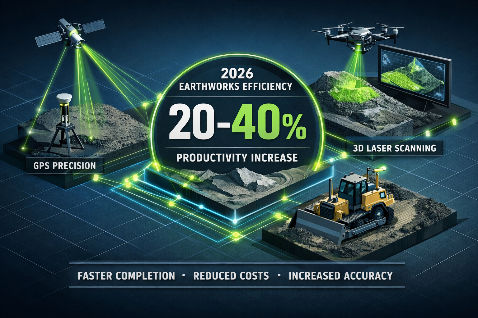
As infrastructure investment surges across developed nations, contractors face mounting pressure to deliver projects faster, more accurately, and with tighter budgets than ever before. Traditional earthmoving methods—relying on survey stakes, manual grade checking, and operator experience—simply can't keep pace with modern demands. Machine control systems have emerged as the solution, integrating precise survey data directly with heavy equipment to achieve real-time grading accuracy that reduces overcuts, eliminates costly rework, and accelerates project timelines by 30-50%.
The integration of surveying expertise with automated earthmoving represents a fundamental shift in construction methodology. Surveyors are no longer simply providers of measurement data; they've become essential partners in collaborative digital workflows where their spatial information feeds directly into machine operating systems, enabling unprecedented levels of precision and efficiency.[1]
Key Takeaways
- 🚜 Machine control systems have transitioned from optional technology to essential infrastructure for modern earthmoving projects, with industry experts identifying them as standard equipment for 2026 construction operations
- 📊 Real-world case studies demonstrate 30-50% efficiency gains, including reduced project timelines, minimized material overcut, and significant fuel savings compared to traditional staking methods
- 🎯 Surveyors provide critical data foundations for machine control operations, including site control networks, digital terrain models, and as-built verification that enable automated equipment to operate safely and accurately
- ☁️ Cloud-based platforms and AI integration are enhancing machine control capabilities in 2026, allowing real-time progress tracking, predictive analytics, and seamless collaboration between survey teams and equipment operators
- 💰 Return on investment typically occurs within 18-24 months, driven by reduced labor costs, faster project completion, lower fuel consumption, and elimination of expensive rework cycles
Understanding Machine Control Systems in Modern Construction
What Are Machine Control Systems?
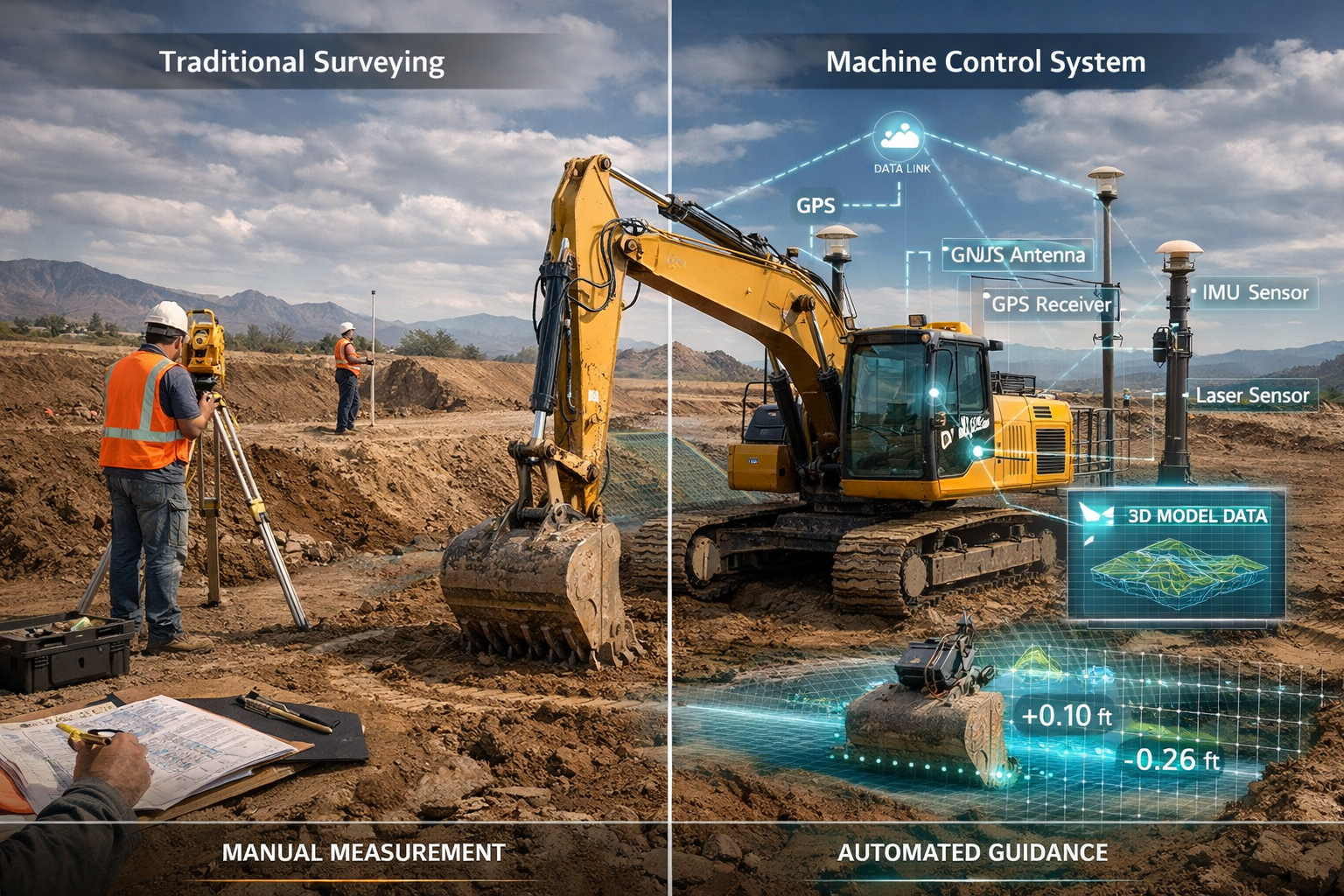
Machine control systems represent the technological convergence of precision positioning, digital design models, and automated equipment guidance. At their core, these systems use Global Navigation Satellite Systems (GNSS), robotic total stations, or laser-based positioning to determine the exact three-dimensional location of construction equipment in real time. This position data is compared against a digital terrain model (DTM) representing the project's final design, and the system provides guidance—or in advanced implementations, direct hydraulic control—to move earth precisely according to plan.[3]
The fundamental components include:
- Positioning sensors (GNSS receivers, inertial measurement units, laser receivers)
- On-board computers with ruggedized displays for operator interface
- Digital design files (DTMs, road alignments, surface models)
- Control software that calculates cut/fill requirements and blade positions
- Hydraulic control systems that can automatically adjust blade angles and elevations
For construction projects in 2026, these systems have evolved far beyond simple grade indication. Modern implementations incorporate machine learning algorithms that optimize blade movements, predict soil behavior, and even suggest the most efficient cutting patterns to minimize passes and fuel consumption.[1]
The Evolution from Stakes to Satellites
Traditional earthmoving relied on surveyors establishing dense networks of grade stakes across construction sites. Equipment operators would work to these physical markers, frequently stopping to check elevations and alignment. This method was labor-intensive, time-consuming, and prone to errors—stakes could be knocked over, misread, or become outdated as designs changed.
The shift to machine control began in the early 2000s with basic grade indication systems that simply told operators whether they were cutting too deep or too shallow. By the 2010s, semi-automatic systems could control blade elevation while operators managed horizontal positioning. Now, in 2026, fully automated systems can execute complex grading operations with minimal operator input, representing what Trimble's Ian Welch describes as "an evolution more than a revolution" toward construction autonomy.[1]
This evolution has fundamentally changed the surveyor's role. Rather than spending days establishing and maintaining stake networks, surveyors now focus on providing accurate, timely digital data that feeds machine control systems—including site control work, digital terrain models, and as-built verification.[1]
Key Technologies Enabling Automation
Several technological advances have converged to make Machine Control Systems in Property Surveying: Automating Earthworks for 2026 Construction Projects a practical reality:
GNSS RTK (Real-Time Kinematic) Positioning provides centimeter-level accuracy by using correction signals from base stations to refine satellite positioning data. Modern multi-constellation receivers track signals from GPS, GLONASS, Galileo, and BeiDou simultaneously, ensuring reliable positioning even in challenging environments.[2]
Inertial Measurement Units (IMUs) combine accelerometers and gyroscopes to track equipment orientation and movement, filling gaps when GNSS signals are temporarily obstructed and enabling precise control of complex attachments like excavator buckets and grader blades.
Robotic Total Stations offer an alternative to GNSS in areas with poor satellite visibility, using automated tracking prisms mounted on equipment to provide precise positioning data via traditional surveying methods integrated into modern control systems.
LiDAR and 3D Laser Scanning technologies enable rapid terrain capture for creating accurate existing condition models, while also providing as-built verification data that confirms finished grades match design specifications.[2]
Cloud-Based Data Management platforms allow survey teams, equipment operators, and project managers to access the same design files and progress data in real time, eliminating version control issues and enabling rapid response to design changes.[1]
The Surveyor's Critical Role in Machine Control Implementation
Data Preparation and Digital Terrain Modeling
The success of any machine control project hinges on the quality of survey data and digital models provided to equipment operators. Surveyors working on Machine Control Systems in Property Surveying: Automating Earthworks for 2026 Construction Projects must master new skills beyond traditional measurement techniques.
Site Control Networks form the foundation of machine control operations. Surveyors establish precise horizontal and vertical control points using GNSS observations tied to national datums. For machine control applications, these networks typically require:
- Horizontal accuracy of ±10mm or better
- Vertical accuracy of ±5mm for finished grade applications
- Redundant measurements to ensure reliability
- Strategic point placement for optimal GNSS base station locations or total station setups
Digital Terrain Model Creation transforms raw survey data into machine-readable surface models. Using specialized software like Carlson Construction or Trimble Business Center, surveyors process point clouds from GNSS surveys, drone photogrammetry, or laser scanning to create accurate representations of existing conditions.[6] These models must include:
| Model Component | Specification | Purpose |
|---|---|---|
| Surface density | Points every 5-10m minimum | Capture terrain variations |
| Breaklines | All significant grade changes | Define ridges, valleys, edges |
| Feature codes | Standardized classification | Identify structures, utilities |
| Coordinate system | Project-specific, clearly documented | Ensure consistency across platforms |
| Quality control | Comparison to check shots | Verify model accuracy |
Design Model Preparation involves converting engineering plans into three-dimensional surfaces and alignments that machine control systems can interpret. This process requires close collaboration with civil engineers and understanding of construction sequencing—models must represent not just the final design, but intermediate grades for multi-lift operations.[5]
Reality Capture and As-Built Verification
Modern surveying for machine control extends beyond initial data collection to include continuous monitoring and verification throughout construction. Reality capture technologies combined with AI and machine learning enable surveyors to document conditions and visually track progress in real time.[1]
UAV Photogrammetry has become standard practice for 2026 earthwork projects. Drones equipped with high-resolution cameras can survey large sites in hours rather than days, generating dense point clouds and orthophotos that show current conditions. When processed through cloud platforms, this data can be compared against design models to identify areas requiring additional work or potential overcut situations before they become costly problems.
Mobile Mapping Systems mounted on vehicles or carried by surveyors capture continuous spatial data as they move through a site. These systems combine GNSS positioning with laser scanners and cameras to create georeferenced 3D models, particularly useful for linear projects like roads and pipelines where traditional static scanning would be inefficient.
As-Built Documentation represents the final verification that construction meets design specifications. For projects utilizing machine control, surveyors typically conduct as-built surveys using the same GNSS or total station equipment that guided construction, ensuring consistency in measurement methodology. The resulting data feeds into building information modeling (BIM) platforms and facility management systems, where it retains value for decades.[1]
Integration with Construction Management Workflows
Surveyors supporting Machine Control Systems in Property Surveying: Automating Earthworks for 2026 Construction Projects must understand how their data integrates into broader construction management processes. The transition from traditional measurement services to becoming essential partners in collaborative workflows requires new competencies.[1]
BIM Coordination involves ensuring survey data aligns with architectural, structural, and MEP models. For earthwork projects, this means coordinating site grading with foundation elevations, utility locations, and drainage systems. Surveyors must be proficient in software platforms like Autodesk Civil 3D, Bentley OpenRoads, or Trimble Siteworks to participate effectively in these coordinated workflows.
Quality Assurance Protocols for machine control projects differ significantly from traditional construction. Rather than periodic spot checks, modern approaches involve continuous monitoring through equipment-mounted sensors and regular drone surveys. Surveyors develop quality control plans that specify:
- Tolerance requirements for different project elements
- Verification frequency and methodology
- Documentation standards for as-built records
- Procedures for addressing out-of-tolerance conditions
Change Management becomes more efficient with machine control systems. When design modifications occur—a common occurrence on complex projects—surveyors can rapidly update digital models and distribute them to equipment operators through cloud platforms, often within hours rather than the days or weeks required to re-stake a site traditionally.
Real-World Performance: Case Studies and Efficiency Gains
Infrastructure Projects Demonstrating 30-50% Improvements
The infrastructure boom sweeping developed nations in 2026 has provided numerous opportunities to document the performance advantages of Machine Control Systems in Property Surveying: Automating Earthworks for 2026 Construction Projects. Real-world case studies consistently demonstrate substantial efficiency gains across multiple metrics.
Highway Widening Project – Efficiency Analysis:
A major motorway expansion project in the UK compared performance data from sections constructed using traditional methods versus machine control:
| Performance Metric | Traditional Method | Machine Control | Improvement |
|---|---|---|---|
| Project duration | 16 weeks | 10 weeks | 37.5% faster |
| Survey labor hours | 1,240 hours | 320 hours | 74% reduction |
| Material overcut | 8,200 m³ | 1,100 m³ | 87% reduction |
| Fuel consumption | 45,600 liters | 28,300 liters | 38% savings |
| Rework incidents | 14 occurrences | 2 occurrences | 86% reduction |
The project manager noted that eliminating the need for dense stake networks freed survey crews to focus on quality verification and problem-solving, while operators appreciated the confidence of knowing their blade position precisely at all times.
Commercial Development Site Preparation:
A 25-hectare commercial development required complex grading to accommodate multiple buildings, parking areas, and stormwater management features. The contractor implemented machine control on excavators, dozers, and motor graders, with chartered surveyors providing continuous support for data preparation and verification.
Results included:
- ✅ 43% reduction in total earthwork duration (14 weeks vs. 24.5 weeks estimated)
- ✅ Subgrade achieved within ±15mm tolerance on 97% of verification points
- ✅ Zero utility strikes attributed to accurate as-built data and real-time positioning
- ✅ Client approval of final grades in single inspection versus typical multiple re-checks
The surveying firm reported that while initial data preparation required significant effort, the elimination of ongoing staking work and reduced rework actually decreased total survey hours by approximately 40% compared to similar projects completed using traditional methods.
Quantifying Return on Investment
Understanding the financial benefits of machine control implementation helps justify the technology investment for contractors and clients alike. The ROI calculation extends beyond simple time savings to encompass multiple cost factors.
Direct Cost Savings:
- Labor reduction: Fewer survey crew hours for staking and grade checking
- Material savings: Minimized overcut reduces hauling and disposal costs
- Fuel efficiency: Optimized blade movements and reduced rework passes
- Equipment productivity: Machines operate continuously rather than waiting for grade checks
Indirect Benefits:
- Schedule acceleration: Earlier project completion enables faster revenue recognition
- Quality improvement: Reduced defects and rework protect profit margins
- Safety enhancement: Fewer personnel working around active equipment
- Client satisfaction: Accurate, on-time delivery leads to repeat business
For a typical mid-sized contractor investing in machine control systems for multiple pieces of equipment, the financial picture often looks like this:
Initial Investment: £180,000-£250,000 (equipment, software, training)
Annual Savings: £120,000-£160,000 (labor, materials, fuel, rework)
Payback Period: 18-24 months
5-Year Net Benefit: £400,000-£600,000
These figures align with industry consensus that machine control systems typically achieve positive ROI within the first two years of implementation, with cumulative benefits growing substantially over equipment lifespans.[4]
Overcoming Common Implementation Challenges
While the benefits of Machine Control Systems in Property Surveying: Automating Earthworks for 2026 Construction Projects are substantial, successful implementation requires addressing several common challenges:
Skill Development and Training represents the most significant hurdle for many organizations. Equipment operators must learn new interfaces and trust automated systems, while surveyors need proficiency in digital modeling software and understanding of machine control requirements. Progressive contractors invest in comprehensive training programs, often partnering with equipment manufacturers and software vendors to develop competency across their workforce.
Data Quality and Consistency issues can undermine machine control effectiveness. Poorly constructed digital models, coordinate system mismatches, or inadequate site control networks lead to frustration and loss of confidence in the technology. Establishing rigorous quality assurance protocols and investing in experienced survey personnel pays dividends in system reliability.
Technology Integration challenges arise when attempting to connect machine control systems with existing project management software, accounting systems, and client reporting requirements. Cloud-based platforms have improved interoperability significantly in 2026, but organizations still need clear data management strategies and sometimes custom integration solutions.[1]
Change Management within organizations requires leadership commitment and patience. Some operators and surveyors resist new technologies, preferring familiar traditional methods. Successful implementations typically involve early adopters demonstrating benefits on pilot projects, creating internal champions who help drive broader organizational acceptance.
Advanced Applications and Future Developments
Autonomous and Semi-Autonomous Operations
The path to autonomy in construction continues to evolve throughout 2026, with machine control systems serving as the practical foundation for increasingly automated task execution.[1] While fully autonomous earthmoving remains primarily in testing phases, semi-autonomous operations are becoming commonplace on major projects.
Automated Dozing systems can execute complex grading patterns with minimal operator input. The operator defines work boundaries and priorities, then monitors system performance while the machine optimizes blade movements, track speed, and cutting depth to achieve design grades efficiently. These systems incorporate:
- Terrain awareness algorithms that analyze soil conditions and adjust cutting strategies
- Obstacle detection sensors that identify personnel, equipment, or unexpected objects
- Productivity optimization that balances speed against fuel consumption and wear
- Automatic blade control that maintains optimal cutting angles throughout passes
Compaction Management represents another area where automation enhances outcomes. Intelligent compaction systems integrate machine control positioning with onboard sensors measuring soil density, moisture content, and compaction effort. The system creates real-time maps showing areas meeting specification and those requiring additional passes, eliminating guesswork and ensuring uniform results.[3]
Excavation Automation has advanced significantly, particularly for repetitive tasks like trench digging or foundation excavation. Modern systems can automatically control bucket position and swing movements to follow design alignments, with operators primarily managing travel and monitoring safety.
Integration with Broader Digital Construction Ecosystems
Machine Control Systems in Property Surveying: Automating Earthworks for 2026 Construction Projects increasingly function as components within comprehensive digital construction ecosystems rather than standalone technologies. This integration creates value throughout project lifecycles.
BIM-to-Field Workflows enable seamless transfer of design intent from engineering software to construction equipment. Surveyors prepare machine control models directly from BIM environments, ensuring consistency between design documentation and field implementation. As-built data captured by machine control systems flows back into BIM models, creating accurate digital twins for facility management.[1]
Connected Job Sites utilize Internet of Things (IoT) sensors and telematics systems to create comprehensive situational awareness. Machine control positioning data combines with fuel consumption monitoring, maintenance alerts, geofencing, and productivity analytics to provide project managers with real-time visibility into operations. Cloud platforms aggregate this data, enabling:
- Fleet management optimization across multiple simultaneous projects
- Predictive maintenance that reduces unexpected equipment failures
- Resource allocation based on actual productivity rather than estimates
- Client reporting with visual progress tracking and quantity verification
GIS Integration connects construction phase data with long-term asset management systems. The spatial information collected during earthwork operations—precise locations of utilities, subsurface conditions, compaction results—retains value for decades, enabling organizations to shift from reactive to predictive maintenance approaches that can reduce operational costs by as much as 40%.[1]
Emerging Technologies Shaping 2026 and Beyond
Several technological trends identified by industry experts are enhancing machine control capabilities as the surveying profession advances through 2026.[1][4]
Artificial Intelligence and Machine Learning applications are expanding beyond simple automation to include:
- Predictive analytics that forecast equipment performance and maintenance needs
- Automated quality control using computer vision to identify defects or deviations
- Optimization algorithms that suggest most efficient construction sequences
- Natural language interfaces allowing operators to interact with systems conversationally
Advanced Reality Capture combining photogrammetry, LiDAR, and thermal imaging provides unprecedented detail about site conditions. When processed through AI-enhanced software, this data enables automated identification of features, measurement extraction, and change detection that would require hours of manual analysis using traditional methods.[2]
5G Connectivity enables real-time transmission of large datasets between field equipment, office systems, and cloud platforms. This bandwidth supports live video feeds from equipment cameras, instant model updates, and collaborative problem-solving with remote experts—capabilities particularly valuable for complex projects or when specialized expertise isn't available on-site.
Augmented Reality (AR) Interfaces are beginning to appear in machine control applications, overlaying design information onto operators' views of actual site conditions. While still emerging, AR promises to enhance spatial understanding and reduce cognitive load for operators managing complex three-dimensional grading tasks.
Practical Implementation Guide for Construction Professionals
Selecting Appropriate Machine Control Solutions
Choosing the right machine control technology for specific project requirements involves evaluating several factors beyond simple cost considerations. Different applications demand different capabilities, and understanding these nuances prevents over-investment in unnecessary features or under-specification that limits effectiveness.
Project Type Considerations:
For linear infrastructure projects (roads, pipelines, utilities), systems with strong alignment and corridor modeling capabilities provide the most value. These applications benefit from dual-GNSS configurations that control both blade elevation and cross-slope simultaneously, essential for maintaining proper road crown or pipe gradients.
For site development projects (commercial pads, residential subdivisions), surface-based systems that can handle multiple design planes and drainage features work best. These projects often involve frequent design changes, so systems with robust cloud connectivity and rapid model update capabilities reduce disruption.
For specialized applications (sports fields, solar farms, precision agriculture), laser-based systems may offer advantages over GNSS in terms of accuracy and consistency, particularly for large flat areas where a single rotating laser can provide reference for multiple machines simultaneously.
Equipment Fleet Considerations:
Organizations operating diverse equipment fleets benefit from manufacturer-agnostic control systems that can be transferred between different machine brands, maximizing utilization and reducing training complexity. However, integrated factory-installed systems often provide superior reliability and warranty coverage, making them attractive for contractors committed to specific equipment brands.
Software Ecosystem Integration:
Evaluate how machine control systems integrate with existing survey software, project management platforms, and accounting systems. Systems that support open data formats (LandXML, IFC, DXF) provide greater flexibility than proprietary formats requiring specific software packages.
Establishing Effective Survey Workflows
Implementing Machine Control Systems in Property Surveying: Automating Earthworks for 2026 Construction Projects successfully requires establishing efficient workflows that support both initial data preparation and ongoing project support.
Pre-Construction Phase:
- Site reconnaissance to evaluate GNSS visibility, identify control point locations, and assess reality capture requirements
- Control network establishment using static GNSS observations or total station traverses tied to national datums
- Existing conditions survey using appropriate technology (GNSS, drone, laser scanning) based on site size and complexity
- Digital model preparation from engineering plans, including quality control verification against design documentation
- System testing with equipment operators to verify model accuracy and resolve any issues before production work begins
Construction Phase:
- Daily calibration of machine control systems to site control network
- Model distribution through cloud platforms or direct file transfer to equipment computers
- Progress monitoring using periodic drone surveys or equipment-generated production data
- Quality verification through random spot checks with GNSS rover or total station
- Issue resolution when discrepancies arise between design intent and field conditions
Post-Construction Phase:
- As-built survey documenting final constructed conditions
- Compliance verification comparing as-built data against design tolerances
- Data archival for warranty purposes and future reference
- Lessons learned documentation to improve processes on subsequent projects
Training and Competency Development
The human element remains critical to successful machine control implementation. Even the most sophisticated technology delivers poor results without properly trained personnel operating and supporting it.
Operator Training Programs should address:
- System fundamentals: Understanding how positioning works and what affects accuracy
- Interface navigation: Efficiently using displays, menus, and control functions
- Model interpretation: Reading three-dimensional design representations and understanding cut/fill indicators
- Troubleshooting: Identifying and resolving common issues without requiring external support
- Safety protocols: Operating automated equipment safely around personnel and other machines
Surveyor Competency Development requires:
- Digital modeling software: Proficiency in creating accurate, construction-ready surface models
- Quality control procedures: Verifying model accuracy and identifying potential issues
- Coordinate systems: Understanding datums, projections, and transformations
- Reality capture technologies: Operating drones, laser scanners, and mobile mapping systems
- Communication skills: Explaining technical concepts to operators and project managers
Many equipment manufacturers and software vendors offer certification programs that provide structured learning paths and validate competency levels. Investing in these programs accelerates skill development and demonstrates organizational commitment to quality implementation.
Organizations should also consider developing internal mentorship programs pairing experienced personnel with those new to machine control technology, facilitating knowledge transfer and building institutional expertise that transcends individual employees.
Regulatory Compliance and Quality Standards
Industry Standards and Specifications
As machine control technology has matured, various industry organizations have developed standards governing its application on construction projects. Understanding these requirements ensures compliance and helps establish appropriate quality benchmarks.
Accuracy Specifications vary by project type and jurisdiction but generally follow patterns like:
- Subgrade preparation: ±25mm vertical tolerance
- Base course: ±15mm vertical tolerance
- Finished surfaces: ±10mm vertical tolerance
- Horizontal positioning: ±50mm for general earthwork, ±25mm for precise applications
These tolerances influence survey control network design, as positioning systems must deliver accuracy significantly better than final tolerance requirements to account for multiple error sources throughout the measurement-to-construction chain.
Documentation Requirements for projects using machine control often include:
- Control network survey reports with adjustment statistics and accuracy assessments
- Digital model certification confirming models accurately represent design intent
- Calibration records documenting daily system checks and adjustments
- As-built survey data in specified formats and coordinate systems
- Quality verification reports showing compliance with tolerance requirements
Many public sector clients now specifically require machine control technology for earthwork contracts above certain value thresholds, recognizing the quality and efficiency benefits these systems provide.
Professional Liability and Risk Management
The integration of surveying data with automated construction equipment creates new considerations for professional liability and risk management that chartered surveyors must address.
Professional Standards from organizations like RICS (Royal Institution of Chartered Surveyors) are evolving to address machine control applications. Surveyors providing data for automated construction should:
- Maintain appropriate professional indemnity insurance covering technology-enabled construction applications
- Document quality assurance procedures demonstrating due diligence in data preparation
- Establish clear scope definitions regarding responsibilities for model accuracy versus design accuracy
- Implement version control systems preventing use of outdated or superseded models
- Maintain competency through continuing professional development in relevant technologies
Contractual Considerations should clearly delineate responsibilities between surveyors, contractors, engineers, and clients. Key issues to address include:
- Who owns and maintains digital models throughout project duration?
- What verification procedures confirm model accuracy before construction begins?
- How are design changes communicated and implemented in machine control systems?
- What constitutes acceptable tolerance for as-built verification?
- Who bears responsibility if equipment operates according to an inaccurate model?
Working with legal counsel experienced in construction technology helps organizations develop appropriate contract language that protects their interests while enabling collaborative project delivery.
Cost-Benefit Analysis and Business Case Development

Building the Financial Justification
For organizations considering investment in Machine Control Systems in Property Surveying: Automating Earthworks for 2026 Construction Projects, developing a comprehensive business case helps secure stakeholder buy-in and guides implementation decisions.
Capital Investment Components:
| Item | Typical Cost Range | Notes |
|---|---|---|
| Machine control hardware (per machine) | £15,000-£45,000 | Varies by system sophistication |
| GNSS base station and rover | £25,000-£40,000 | Shared across multiple projects |
| Software licenses (annual) | £3,000-£8,000 | Per seat for modeling/processing |
| Drone system (if required) | £8,000-£35,000 | Depends on sensor capabilities |
| Training and implementation | £10,000-£25,000 | Initial investment, ongoing development |
Operating Cost Considerations:
- Software maintenance and updates: Typically 15-20% of license cost annually
- Cellular data plans: For cloud connectivity and real-time corrections
- Equipment calibration and maintenance: Sensors require periodic verification
- Continuing education: Keeping pace with technology evolution
Quantifiable Benefits:
Organizations can typically measure improvements in:
- Labor productivity: Hours required per cubic meter of earthwork
- Material efficiency: Overcut/undercut percentages and hauling costs
- Schedule performance: Days to complete compared to estimates
- Quality metrics: Percentage of work meeting tolerance on first attempt
- Fuel consumption: Liters per operating hour or per cubic meter moved
- Safety incidents: Reduction in personnel working near active equipment
Strategic Benefits:
Beyond direct cost savings, machine control capabilities position organizations for:
- Competitive advantage in bidding technology-specified projects
- Client relationship development through demonstrated innovation
- Talent attraction and retention as skilled workers prefer modern equipment
- Sustainability improvements through reduced material waste and fuel consumption
A well-constructed business case presents both short-term ROI through measurable cost savings and long-term strategic positioning that ensures organizational competitiveness as the construction industry continues its digital transformation.
Financing and Acquisition Strategies
Organizations have several options for acquiring machine control technology, each with different financial implications and strategic considerations.
Direct Purchase provides complete ownership and maximum flexibility but requires significant capital investment. This approach works best for organizations with:
- Strong balance sheets capable of absorbing capital expenditure
- Consistent project pipelines justifying equipment utilization
- In-house technical expertise for maintenance and support
- Long-term strategic commitment to technology leadership
Leasing or Rental reduces upfront costs and provides flexibility to scale capacity with project demands. Benefits include:
- Preservation of capital for other business needs
- Ability to upgrade to newer technology as leases expire
- Potential tax advantages depending on jurisdiction
- Reduced exposure to technology obsolescence risk
Project-Specific Deployment involves acquiring systems for particular contracts with costs incorporated into project budgets. This approach allows organizations to:
- Test technology on pilot projects before broader commitment
- Match sophisticated systems to complex projects while using simpler solutions elsewhere
- Recover investment costs directly from clients through contract pricing
- Build experience and competency progressively
Many equipment manufacturers offer bundled packages combining hardware, software, training, and support services at attractive pricing, simplifying procurement and ensuring compatible components. These packages often include upgrade paths allowing organizations to start with basic systems and add capabilities as experience and project requirements grow.
Environmental and Sustainability Benefits
Reducing Material Waste and Carbon Footprint
Machine Control Systems in Property Surveying: Automating Earthworks for 2026 Construction Projects deliver significant environmental benefits beyond operational efficiency, supporting construction industry sustainability goals increasingly important to clients and regulators in 2026.
Material Conservation represents the most direct environmental benefit. Traditional earthwork methods typically result in 5-12% material overcut as operators work conservatively to avoid undercut situations requiring expensive rework. Machine control systems reduce overcut to 1-3%, translating to:
- Reduced excavation: Less disturbance to existing site conditions and ecosystems
- Lower hauling requirements: Fewer truck trips removing excess material
- Decreased disposal impacts: Less material requiring landfill or spoil site placement
- Conservation of resources: Reduced need for imported fill material on other projects
On a typical 50,000 cubic meter earthwork project, reducing overcut from 8% to 2% saves 3,000 cubic meters of unnecessary excavation and hauling—equivalent to approximately 300 truck trips and associated fuel consumption.
Fuel Efficiency Improvements result from optimized machine movements and reduced rework. Studies consistently show 25-40% fuel consumption reduction when comparing machine control operations to traditional methods, driven by:
- Elimination of idle time waiting for grade checks
- Optimized cutting patterns that minimize unnecessary passes
- Reduced rework from getting grades right the first time
- Improved operator confidence enabling more aggressive production
Lower fuel consumption directly reduces carbon emissions, with a typical dozer saving 15,000-20,000 liters of diesel annually when equipped with machine control—equivalent to preventing 40-50 tonnes of CO₂ emissions per machine per year.
Ecosystem Protection benefits from precise earthwork execution. Accurate grading minimizes disturbance beyond designated construction limits, protecting adjacent vegetation, waterways, and sensitive areas. This precision proves particularly valuable on projects with environmental constraints or boundary considerations requiring careful work near property lines.
Supporting Green Building and Infrastructure Initiatives
Modern construction increasingly emphasizes sustainability certifications like LEED, BREEAM, or infrastructure-specific frameworks. Machine control technology supports these initiatives through:
Documentation and Verification capabilities that provide detailed records of construction processes, material quantities, and quality compliance—documentation often required for certification applications.
Precision Stormwater Management enabled by accurate grading ensures drainage systems function as designed, preventing erosion and protecting water quality. Machine control systems can maintain the subtle slopes (often 1-2%) required for effective surface drainage that would be extremely difficult to achieve consistently using traditional methods.
Reduced Site Disturbance through efficient construction sequencing and minimal rework preserves more existing vegetation and topsoil, supporting sustainable site development credits in green building rating systems.
Lifecycle Data Creation as machine control systems generate detailed as-built information that feeds into building information models and facility management systems, supporting efficient long-term operation and maintenance—key components of sustainable building performance.[1]
Conclusion: Embracing the Digital Transformation
The integration of Machine Control Systems in Property Surveying: Automating Earthworks for 2026 Construction Projects represents far more than incremental technological improvement—it constitutes a fundamental transformation in how the construction industry approaches earthwork operations. As infrastructure investment accelerates globally and project complexity increases, the efficiency gains, quality improvements, and cost savings these systems deliver have transitioned them from competitive advantage to operational necessity.
The evidence is compelling: projects consistently achieve 30-50% efficiency improvements, material overcut drops by 80-90%, and return on investment typically occurs within 18-24 months. These aren't theoretical benefits—they're documented outcomes from real-world implementations across diverse project types and scales. The surveying profession's role has evolved accordingly, with practitioners becoming essential partners in collaborative digital workflows rather than simply providers of measurement data.[1]
Looking ahead, the convergence of artificial intelligence, cloud-based platforms, and increasingly sophisticated positioning technologies promises continued advancement throughout 2026 and beyond. The path to autonomy that industry experts describe as "evolution more than revolution" continues steadily, with each technological increment building on machine control foundations to enable smarter, more efficient construction processes.[1]
Actionable Next Steps for Implementation
For construction organizations considering machine control adoption:
- Start with pilot projects that offer clear efficiency opportunities and manageable complexity, building experience before tackling more challenging applications
- Invest in comprehensive training for both equipment operators and survey personnel, recognizing that technology alone doesn't deliver results—skilled people operating it do
- Establish partnerships with experienced chartered surveyors who understand machine control data requirements and workflows
- Develop robust data management protocols ensuring quality, version control, and accessibility throughout project lifecycles
- Measure and document performance to quantify benefits, justify continued investment, and identify improvement opportunities
For surveying professionals supporting machine control projects:
- Develop digital modeling competencies through software training and hands-on practice with construction-ready model preparation
- Understand equipment capabilities and limitations by spending time with operators learning how they interact with control systems
- Invest in reality capture technologies like drones and mobile scanning that enable efficient data collection for machine control applications
- Build collaborative relationships with contractors, engineers, and equipment suppliers to create effective project teams
- Stay current with evolving standards through professional development and engagement with organizations like RICS that are establishing best practices for technology-enabled construction
For project owners and developers:
- Specify machine control requirements in contract documents for projects where the technology offers clear benefits
- Recognize value beyond lowest price when evaluating bids, considering quality, schedule, and risk reduction that technology-enabled contractors deliver
- Support data-driven decision making by requiring regular progress documentation and as-built verification
- Plan for digital asset delivery ensuring construction data feeds into facility management systems for long-term value
- Consider sustainability benefits when evaluating project approaches, recognizing machine control's contribution to environmental goals
The digital transformation of construction is accelerating, and Machine Control Systems in Property Surveying: Automating Earthworks for 2026 Construction Projects sits at the center of this evolution. Organizations that embrace these technologies, invest in developing necessary competencies, and establish effective collaborative workflows position themselves for success in an increasingly competitive, quality-focused, and technologically sophisticated industry. The question is no longer whether to adopt machine control systems, but how quickly organizations can implement them effectively to capture the substantial benefits they offer.
References
[1] Doubling Down On Digital – https://amerisurv.com/2026/02/01/doubling-down-on-digital/
[2] The Future Of Land Surveying Technology And Upcoming Trends In 2026 – https://metricop.com/blogs/land-surveying/the-future-of-land-surveying-technology-and-upcoming-trends-in-2026
[3] Underground Technology For Machine Control And Surveying Advancements And Innovation – https://geospatial.trimble.com/en/resources/webinar/underground-technology-for-machine-control-and-surveying-advancements-and-innovation
[4] Doubling Down On Digital Top 6 Surveying Trends Shaping 2026 From Trimble Experts – https://nottinghillsurveyors.com/blog/doubling-down-on-digital-top-6-surveying-trends-shaping-2026-from-trimble-experts
[5] Machine Control Model – https://www.quantumlanddesign.com/machine-control-model
[6] Carlson Construction – https://carlsonps.com/products/carlson-construction