{"cover":"Professional landscape format (1536×1024) hero image featuring bold text overlay 'Building Survey Protocols for Bungalow Subsidence in Clay Soil Regions: Level 3 Essentials Post-2026 Winter Thaws' in extra large 70pt white sans-serif font with dark shadow and semi-transparent navy overlay box, positioned in upper third. Background shows detailed cross-section view of single-story bungalow foundation on expansive clay soil with visible crack patterns, moisture indicators, and root systems near foundation. Split-screen composition showing winter thaw conditions on left and dry summer shrinkage on right. Color scheme: deep navy blue, terracotta clay tones, white text, professional surveying equipment visible. High contrast, technical editorial quality, RICS professional standard aesthetic with subtle grid overlay and measurement annotations","content":["Detailed landscape format (1536×1024) technical illustration showing cutaway view of bungalow roof structure with visible roof spread indicators, wall plate separation, and rafter displacement. Close-up inset showing diagonal crack patterns at 45-degree angles near door and window openings, with measurement calipers indicating 3mm+ crack width. Digital overlay displays thermal imaging heat map in purple and orange tones revealing moisture penetration zones. Professional surveyor in high-visibility vest using laser level equipment in foreground. Clay soil cross-section visible at foundation level showing shrinkage gaps. Technical annotation labels, measurement scales, and diagnostic arrows throughout. Clean architectural drawing aesthetic combined with photorealistic elements","Landscape format (1536×1024) modern surveying scene showing advanced diagnostic technology in action at bungalow site on clay soil. Central focus on surveyor operating ground-penetrating radar equipment with laptop display showing subsurface soil density mapping and void detection. Split composition: left side shows traditional spirit level and crack monitoring gauges on external wall, right side displays tablet with 3D building information modeling and structural analysis software. Background features mature trees with root zone mapping overlay in translucent blue. Weather station equipment visible measuring soil moisture levels. Color palette: professional grey, technology blue, safety orange accents. Documentary photography style with technical precision","Landscape format (1536×1024) comprehensive visual flowchart and timeline showing post-winter thaw inspection protocol for bungalows on clay soil. Central timeline spans January through June 2026 with key inspection milestones marked. Surrounding the timeline are photographic examples: heave damage to floor slabs, damp meter readings on internal walls, external ground level monitoring stakes, and drainage system inspection. Professional surveyor reviewing detailed Level 3 survey report on clipboard in lower right corner. Color-coded severity indicators (green, amber, red) for different subsidence risk levels. Infographic style with clean icons, connecting arrows, and data visualization elements. RICS logo subtly visible on documentation. Professional instructional manual aesthetic"]
Clay shrinkage subsidence claims have surged by 68% across south-east England following the unprecedented freeze-thaw cycles of winter 2025-2026, with single-story bungalows experiencing disproportionately severe structural movement due to their shallow foundation profiles and increased roof spread vulnerability. As property transactions demand greater certainty in 2026, Building Survey Protocols for Bungalow Subsidence in Clay Soil Regions: Level 3 Essentials Post-2026 Winter Thaws have become the critical standard for identifying structural defects that standard homebuyer reports routinely miss.
The combination of extreme winter moisture saturation followed by rapid spring drying has created perfect conditions for accelerated clay soil movement. Traditional survey approaches no longer provide adequate risk assessment for bungalows constructed on expansive clay soils, particularly those built between 1950-1980 with minimal foundation depth. This comprehensive guide outlines the advanced diagnostic protocols, technology-enhanced inspection methods, and regional risk factors that define Level 3 survey excellence in 2026.

Key Takeaways
- Level 3 surveys now incorporate ground-penetrating radar and thermal imaging to detect subsurface clay movement patterns invisible to visual inspection alone
- Post-thaw protocols require specific timing windows (March-May 2026) to accurately assess foundation recovery and identify permanent structural damage
- Bungalow-specific vulnerabilities include roof spread, wall plate separation, and shallow foundation heave that differ significantly from two-story property risks
- Clay soil regions in Surrey, Hertfordshire, Essex, and West London face elevated subsidence risk requiring enhanced monitoring and documentation standards
- Technology integration with BIM modeling and moisture mapping provides transaction certainty that traditional survey methods cannot deliver
Understanding Clay Soil Behaviour and Bungalow Vulnerability Patterns
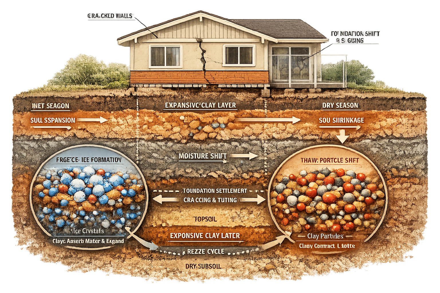
Clay soils expand when wet and shrink when dry, with this volumetric cycle causing cumulative foundation damage over time [1]. This shrink-swell behaviour becomes particularly problematic in bungalow construction where foundation depths typically range between 0.6-1.0 meters—significantly shallower than the 1.5-2.0 meter depths common in modern two-story construction. The reduced foundation mass and lateral stability make bungalows exceptionally vulnerable to differential settlement.
The 2026 Winter Thaw Impact Factor
The winter of 2025-2026 brought unprecedented conditions: extended ground frost penetration to depths of 45cm followed by rapid temperature increases in late February. This created a unique subsidence scenario where clay soils absorbed excessive moisture during thaw, expanding beyond normal seasonal parameters. As temperatures rose through March and April, the subsequent drying phase initiated accelerated shrinkage patterns that traditional survey timing protocols were not designed to capture.
Key vulnerability indicators specific to bungalows include:
- Roof spread caused by inadequate lateral restraint in single-story construction
- Wall plate separation from cavity walls under differential movement
- Shallow foundation heave during clay expansion phases
- Concentrated stress points at window and door openings
- Inadequate tie-beam systems in properties built before 1980
Dry weather and high temperatures are major factors in subsidence emergence in clay soils [2], making the spring-summer transition period of 2026 particularly critical for comprehensive subsidence surveys that capture both the expansion and contraction phases of the clay cycle.
Regional Clay Soil Risk Mapping
UK climate projections show increased shrink-swell vulnerability in south-east England due to climate change [2]. The London Clay formation, which extends across Surrey, Hertfordshire, Essex, and throughout the Greater London area, presents the highest risk profile for bungalow subsidence. Properties in these regions require enhanced scrutiny during Level 3 surveys.
High-risk clay soil regions include:
| Region | Clay Type | Plasticity Index | Subsidence Risk Rating |
|---|---|---|---|
| Surrey | London Clay | 40-60% | ⚠️ Very High |
| Hertfordshire | Boulder Clay | 30-45% | ⚠️ High |
| Essex | London Clay/Glacial Till | 35-55% | ⚠️ Very High |
| West London | London Clay | 45-65% | 🔴 Extreme |
| North-West London | London Clay | 40-60% | ⚠️ Very High |
Properties located in these regions benefit from specialist surveyor expertise available through chartered surveyors in Surrey, chartered surveyors in Hertfordshire, and chartered surveyors in West London who understand local clay behaviour patterns.
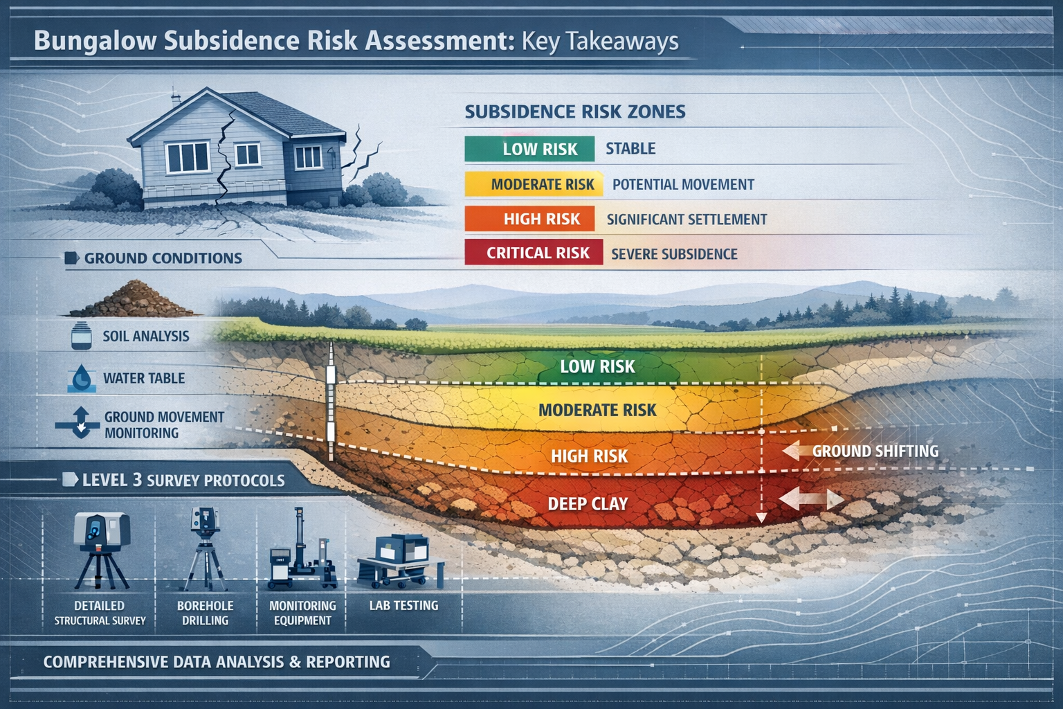
Level 3 Survey Protocol Essentials for Post-Thaw Assessment
Building Survey Protocols for Bungalow Subsidence in Clay Soil Regions: Level 3 Essentials Post-2026 Winter Thaws require a systematic approach that combines traditional structural assessment with advanced diagnostic technology. Unlike standard homebuyer reports that provide surface-level observations, Level 3 surveys deliver comprehensive structural analysis essential for clay soil regions.
Critical Inspection Timing Windows
The post-thaw assessment period (March through June 2026) provides the optimal window for identifying subsidence patterns. Surveys conducted during this period capture:
✅ Immediate post-thaw expansion effects (March-April)
✅ Early drying phase crack propagation (April-May)
✅ Seasonal movement stabilization indicators (May-June)
✅ Vegetation water demand impacts (May onwards)
Scheduling a building survey during these specific windows ensures that structural movement patterns are accurately documented before summer stabilization masks underlying issues.
Roof Spread and Wall Plate Assessment
Roof spread represents one of the most significant structural defects in bungalows on clay soils. As foundations undergo differential settlement, the outward thrust from roof loads increases, causing:
- Horizontal displacement of wall heads by 10-25mm
- Separation between wall plates and cavity walls
- Rafter foot slippage from inadequate restraint fixings
- Ridge beam sagging under increased loading
- Fascia and soffit distortion indicating structural movement
Level 3 inspection protocol requires:
- Internal roof space access with measurement of wall plate position relative to inner leaf
- Rafter-to-wall plate connection assessment using torque testing where accessible
- Ridge beam deflection measurement using laser leveling equipment
- External wall verticality checks with digital inclinometers at 2-meter intervals
- Photographic documentation with measurement scales for insurance and remediation purposes
Heave Detection and Floor Slab Analysis
While subsidence receives primary attention, heave (upward ground movement) poses equally significant risks in clay soils following winter saturation. Bungalows with suspended timber floors or solid ground-bearing slabs exhibit different heave signatures requiring specialized assessment protocols [3].
Heave indicators in bungalows include:
- Upward floor slab displacement creating door binding
- Compression cracking in internal walls (opposite pattern to subsidence)
- Floor level variations exceeding 15mm over 3-meter spans
- Separation between floor slabs and perimeter walls
- Drainage pipe fractures from upward ground pressure
Level 3 surveys employ laser scanning technology to create detailed floor level topography maps, identifying heave patterns that visual inspection cannot detect. This data integrates with building information modeling (BIM) systems to provide three-dimensional structural analysis.
Damp Penetration and Moisture Mapping
The relationship between clay soil movement and moisture penetration creates compounding structural risks. Key signs of clay shrinkage include diagonal wall cracks over 3mm thick, visible near doors and windows [2], which subsequently allow water ingress that accelerates deterioration.
Advanced moisture mapping protocols include:
🔍 Thermal imaging surveys revealing hidden moisture pathways behind finishes
🔍 Electrical resistance moisture meters at 500mm grid intervals on affected walls
🔍 Calcium carbide testing for concrete floor slab moisture content
🔍 Infrared thermography identifying thermal bridging and insulation defects
🔍 Salt contamination analysis where rising damp is suspected
These diagnostic approaches, combined with traditional visual inspection, provide the comprehensive assessment required for building surveyor services in clay soil regions.
Crack Pattern Analysis and Monitoring Protocols
Not all cracks indicate active subsidence. Level 3 surveys differentiate between:
Active subsidence cracks:
- Progressive diagonal patterns at 45-60 degree angles
- Width exceeding 3mm with evidence of recent movement
- Located near building corners and openings
- Visible both internally and externally
- Associated with floor level changes
Inactive or settlement cracks:
- Vertical or near-vertical orientation
- Consistent width under 2mm
- Evidence of previous repair
- No associated structural distortion
- Isolated to specific building elements
Professional surveyors install tell-tale crack monitors or Avongard automated monitoring systems on suspect cracks, with follow-up assessments scheduled at 3-month intervals to establish movement patterns. This longitudinal data proves essential for insurance claims and remediation planning.
Technology-Enhanced Diagnostics and Regional Risk Factors
Building Survey Protocols for Bungalow Subsidence in Clay Soil Regions: Level 3 Essentials Post-2026 Winter Thaws now incorporate advanced diagnostic technologies that transform subsidence assessment from subjective observation to quantified structural analysis. These tools provide the transaction certainty that modern property purchases demand.
Ground-Penetrating Radar (GPR) Applications
GPR technology has revolutionized subsurface investigation without excavation. For bungalows on clay soils, GPR reveals:
- Void formation beneath floor slabs indicating clay shrinkage
- Foundation depth verification against building regulation requirements
- Drainage system integrity and pipe displacement patterns
- Tree root proximity to foundations and their extent
- Soil density variations indicating differential settlement zones
GPR surveys typically cost £800-1,500 for standard bungalow plots but deliver subsurface intelligence impossible to obtain through visual inspection alone. This investment proves particularly valuable in high-risk regions where chartered surveyors in Essex and chartered surveyors in North-West London routinely encounter complex clay soil conditions.
Building Information Modeling (BIM) Integration
Modern Level 3 surveys increasingly incorporate BIM technology to create digital twins of surveyed properties. This approach enables:
✨ 3D visualization of structural defects and movement patterns
✨ Temporal analysis comparing current conditions against historical data
✨ Remediation planning with accurate quantity surveying
✨ Insurance documentation with comprehensive visual evidence
✨ Future monitoring through comparative scanning
BIM integration transforms static survey reports into dynamic structural health records, particularly valuable for properties requiring ongoing monitoring or staged remediation works.
Vegetation and Tree Root Risk Assessment
Trees are the single biggest contributor to clay shrinkage subsidence through moisture extraction [1]. Bungalows face heightened risk due to their shallow foundations and proximity to mature vegetation in established residential areas.
Critical assessment factors include:
| Tree Species | Mature Height | High Risk Distance | Moderate Risk Distance |
|---|---|---|---|
| Oak | 20-30m | 30m | 40m |
| Poplar | 25-35m | 35m | 45m |
| Willow | 15-25m | 25m | 35m |
| Ash | 20-30m | 30m | 40m |
| Elm | 20-30m | 30m | 40m |
Level 3 surveys document all vegetation within 50 meters of the property, with species identification, maturity assessment, and root zone mapping. Where high-risk trees exist, recommendations typically include:
- Specialist arboricultural surveys with root mapping
- Soil moisture monitoring at foundation depth
- Consideration of tree preservation orders before removal
- Root barrier installation specifications
- Alternative foundation underpinning designs
Recommended measures include specialist surveyor advice, careful tree management, and proper foundation design [2], making vegetation assessment a non-negotiable component of comprehensive subsidence surveys.
Regional Risk Factors and Local Authority Planning Considerations
Properties in specific local authority areas face additional scrutiny due to known clay soil conditions and historical subsidence patterns. Level 3 surveys in these regions must address:
Surrey and surrounding areas (chartered surveyors in Kingston, chartered surveyors in Richmond):
- Extensive London Clay deposits with high plasticity
- Mature tree coverage in established residential areas
- Historical bungalow construction (1950s-1970s) with minimal foundations
- Water table variations affecting clay moisture content
West London boroughs (chartered surveyors in Hounslow, chartered surveyors in Ealing):
- Dense urban development affecting drainage patterns
- Modified ground conditions from previous development
- Proximity to major transport infrastructure affecting vibration
- Complex ownership boundaries requiring boundary surveys
Hertfordshire and Essex regions (chartered surveyors in St Albans):
- Mixed clay deposits with variable shrinkage potential
- Agricultural land conversion affecting soil hydrology
- Chalk aquifer interactions with overlying clay
- Rural tree coverage with limited management
Insurance and Remediation Cost Implications
Level 3 surveys provide the detailed documentation required for subsidence insurance claims and remediation contractor tendering. Comprehensive reports should include:
📋 Structural engineer referral recommendations where movement exceeds acceptable limits
📋 Remediation cost estimates based on current market rates
📋 Insurance excess considerations (typically £1,000-2,500 for subsidence claims)
📋 Temporary works requirements for urgent stabilization
📋 Monitoring protocol specifications for ongoing assessment
Properties requiring structural intervention benefit from residential structural engineers who can design appropriate underpinning, soil stabilization, or drainage improvement schemes. Where disputes arise regarding responsibility or extent of damage, expert witness reports provide the technical evidence required for legal proceedings.
Climate Change Adaptation and Future-Proofing
The 2026 winter thaw events highlight the increasing importance of climate resilience in property assessment. Level 3 surveys now incorporate forward-looking analysis considering:
- Projected rainfall pattern changes affecting clay moisture cycles
- Temperature extreme frequencies driving shrink-swell amplitudes
- Vegetation stress patterns altering water demand profiles
- Drainage system capacity under increased precipitation events
- Foundation design adequacy for future climate scenarios
This future-focused approach ensures that survey recommendations address not only current defects but also anticipated climate-driven risks over the property's service life.
Conclusion
Building Survey Protocols for Bungalow Subsidence in Clay Soil Regions: Level 3 Essentials Post-2026 Winter Thaws represent a fundamental evolution in property assessment standards. The unprecedented freeze-thaw cycles of winter 2025-2026 have exposed the inadequacy of traditional survey approaches for bungalows on expansive clay soils, particularly across high-risk regions including Surrey, Hertfordshire, Essex, and Greater London.
The integration of advanced diagnostic technologies—ground-penetrating radar, thermal imaging, BIM modeling, and automated monitoring systems—transforms subsidence assessment from subjective observation to quantified structural analysis. This technology-enhanced approach delivers the transaction certainty that modern property purchases demand, while providing the comprehensive documentation required for insurance claims and remediation planning.
Critical success factors for effective Level 3 surveys include:
✅ Timing assessments within the March-June 2026 post-thaw window
✅ Engaging RICS-qualified surveyors with clay soil expertise
✅ Incorporating roof spread, heave, and damp assessments specific to bungalows
✅ Documenting vegetation risks and tree root proximity
✅ Utilizing technology-enhanced diagnostics for subsurface investigation
✅ Establishing monitoring protocols for ongoing structural health assessment
Actionable Next Steps
For property owners, buyers, and professionals navigating bungalow transactions in clay soil regions:
- Schedule Level 3 surveys between March and June to capture post-thaw movement patterns before summer stabilization
- Verify surveyor qualifications ensuring RICS membership and specific subsidence assessment experience
- Request technology-enhanced diagnostics including thermal imaging and moisture mapping as standard survey components
- Document all vegetation within 50 meters of the property with species identification and maturity assessment
- Establish baseline monitoring using crack gauges or automated systems on any suspect structural movement
- Engage specialist support from structural engineers where movement exceeds 3mm or shows progressive patterns
- Review insurance coverage ensuring adequate subsidence protection with reasonable excess levels
The combination of extreme weather events, aging bungalow stock, and expansive clay soils creates a perfect storm for structural defects that standard surveys routinely miss. Investing in comprehensive Level 3 assessment protocols protects transaction value, prevents costly post-purchase surprises, and ensures structural safety for decades to come.
As climate change drives increasingly volatile weather patterns, the importance of rigorous subsidence assessment will only intensify. Property stakeholders who embrace technology-enhanced diagnostic protocols and engage specialist surveyor expertise position themselves for confident decision-making in an increasingly complex risk landscape.
References
[1] Clay Shrinkage Subsidence A Homeowners Guide Geobear – https://www.geobear.com/en-us/clay-shrinkage-subsidence-a-homeowners-guide-geobear
[2] Six Ways To Prepare Your Home For Climate Change Related Subsidence – https://www.bgs.ac.uk/news/six-ways-to-prepare-your-home-for-climate-change-related-subsidence/
[3] Soil Subsidence What Building Owners Need To Know 20834 – https://www.facilitiesnet.com/designconstruction/article/Soil-Subsidence-What-Building-Owners-Need-To-Know–20834