Modern terrestrial laser scanners now capture more than 2 million data points per second, achieving positional accuracies down to plus or minus 1 to 2 millimetres — a level of precision once reserved for aerospace engineering that is now a standard expectation in property surveying [1]. For professionals who still rely solely on tape measures and total stations, that figure represents both a warning and an opportunity.
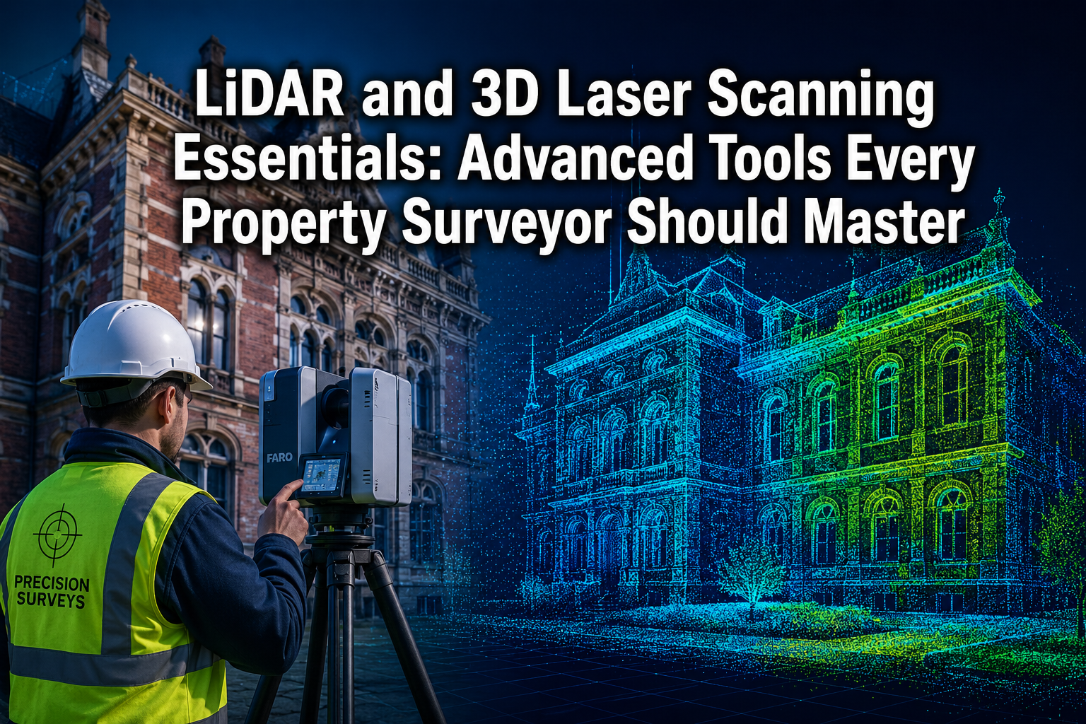
This guide to LiDAR and 3D Laser Scanning Essentials: Advanced Tools Every Property Surveyor Should Master covers the core technology, compares it with traditional methods, maps out 2026 workflow integrations, and provides practical training guidance for surveyors at every career stage.
Key Takeaways
- LiDAR and terrestrial laser scanning deliver millimetre-level accuracy far beyond conventional survey methods, reducing repeat site visits and costly errors.
- Combining terrestrial LiDAR, GNSS RTK positioning, and drone-based scanning creates a flexible, project-specific toolkit that maximises both speed and precision.
- Point cloud data can be converted directly into intelligent BIM models, streamlining collaboration between surveyors, architects, and engineers.
- Digital twins derived from scan data are becoming a standard deliverable, supporting asset management, virtual tours, and renovation planning.
- Structured training in scan-to-BIM workflows and data processing software is now a core professional competency for property surveyors.
What Is LiDAR and Why Does It Matter for Property Surveyors
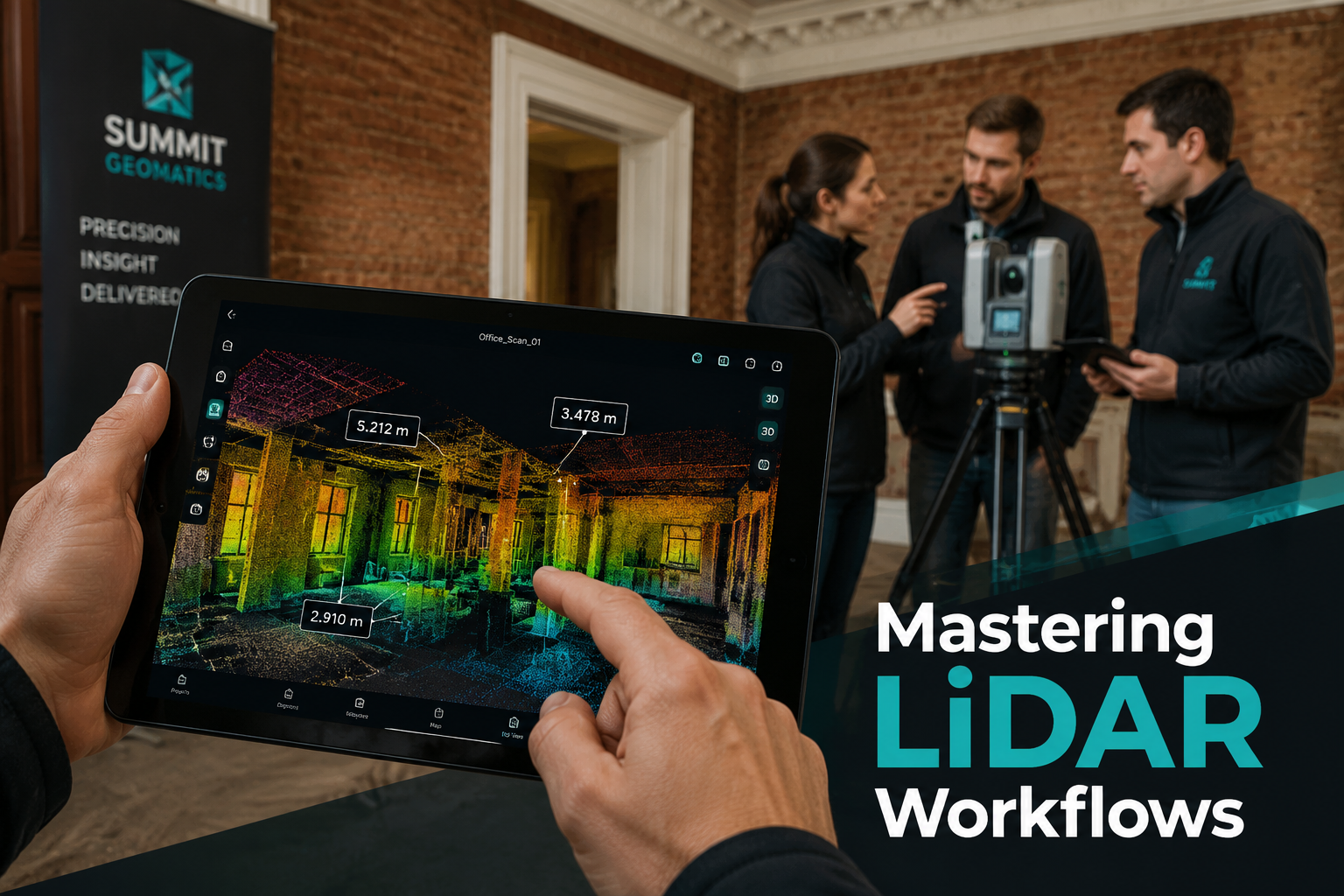
LiDAR stands for Light Detection and Ranging. The technology works by emitting rapid pulses of laser light toward a target surface and measuring the time each pulse takes to return to the sensor. From millions of these measurements, the scanner builds a dense point cloud — a three-dimensional map of every surface the laser touches.
For property surveyors, this matters for a straightforward reason: spatial data that once took days to collect manually can now be gathered in hours, with a level of detail that hand measurements simply cannot replicate.
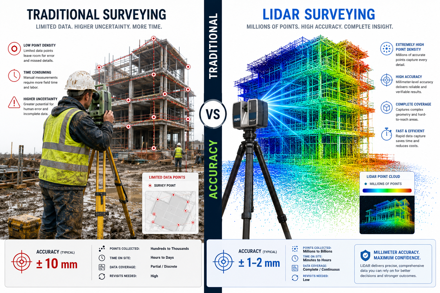
How LiDAR Compares to Traditional Survey Methods
| Method | Typical Accuracy | Data Points Collected | Time on Site |
|---|---|---|---|
| Tape measure and sketch | Plus or minus 10-30 mm | Dozens to hundreds | Hours to days |
| Total station | Plus or minus 2-5 mm | Hundreds to thousands | Hours |
| Photogrammetry | Plus or minus 3-10 mm | Millions (image-derived) | Moderate |
| Terrestrial LiDAR | Plus or minus 1-2 mm | 2 million+ per second | Minutes to hours |
| Drone LiDAR | Plus or minus 2-5 mm | Millions per flight | Minutes |
Traditional methods remain valid for simple, small-scale tasks. However, on complex sites — multi-storey buildings, heritage structures, sites with restricted access — the speed and density advantages of LiDAR are decisive [6].
A key limitation of conventional surveying is occlusion: areas hidden from the surveyor's line of sight simply go unmeasured. LiDAR scanners placed at multiple positions around a site generate overlapping point clouds that together eliminate almost all blind spots, producing a complete spatial record.
For surveyors working across London and the South East, understanding these tools is increasingly relevant to delivering competitive, high-quality service. Whether conducting boundary surveys in London or producing detailed schedule of condition reports, the precision that LiDAR offers can materially strengthen the quality of evidence in any survey document.
Core LiDAR Technologies and Their Applications in Property Surveying
Not all LiDAR systems are the same. Understanding the differences allows surveyors to select the right tool for each project.
Terrestrial Laser Scanning
Terrestrial laser scanners (TLS) are tripod-mounted devices used on the ground. They rotate through 360 degrees, capturing detailed point clouds of building facades, interiors, and surrounding land. TLS is the workhorse of as-built surveys, heritage recording, and structural monitoring.
Key applications include:
- As-built floor plans and elevations for existing buildings
- Pre-purchase condition documentation
- Structural deformation monitoring over time
- Evidence gathering for dilapidation surveys
Mobile LiDAR
Mobile systems mount scanners onto vehicles, backpacks, or handheld units. The operator walks or drives through a space while the scanner continuously captures data. This approach sacrifices a small degree of accuracy in exchange for dramatically faster data collection across large areas [3].
Mobile LiDAR suits:
- Large commercial properties and campuses
- Road and infrastructure corridors
- Rapid condition surveys of multiple units
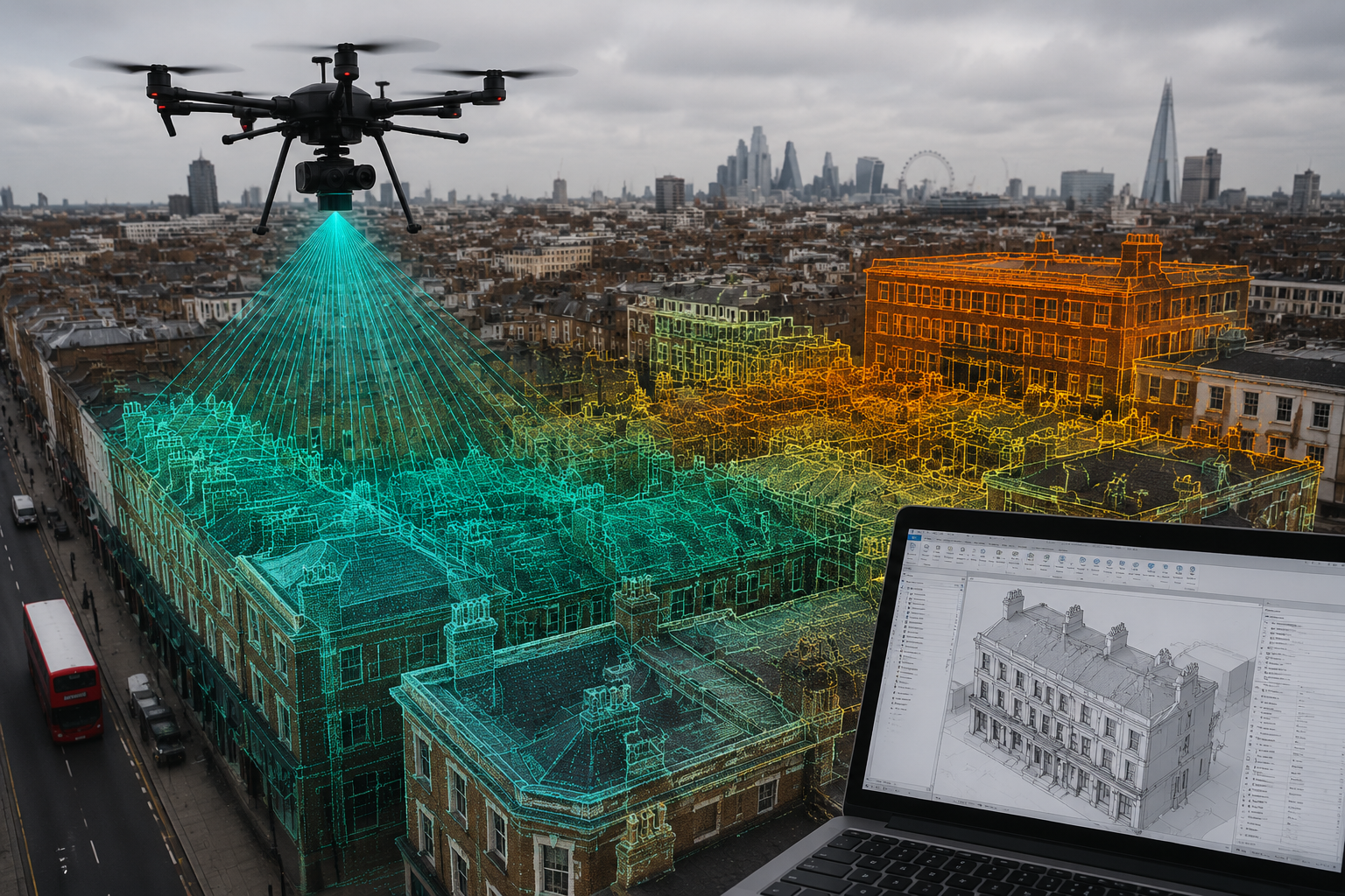
Drone-Based LiDAR and Photogrammetry
Unmanned aerial vehicles (UAVs) fitted with LiDAR sensors or high-resolution cameras can survey rooftops, tall facades, and large land parcels that would be hazardous or impractical to access on foot. Drone photogrammetry, while technically distinct from LiDAR, produces comparable point clouds and is often used alongside it [3].
"Surveying firms are increasingly utilising mobile LiDAR and drone photogrammetry for large-scale terrain and roof inspections, offering sub-millimetre accuracy and nationwide reach." [3]
Drone surveys are particularly valuable for specific defect reports on tall or complex structures where access scaffolding would otherwise be required.
GNSS RTK Integration
Global Navigation Satellite System Real-Time Kinematic (GNSS RTK) positioning anchors point cloud data to real-world coordinates with centimetre-level accuracy. Combining GNSS RTK with terrestrial or mobile LiDAR allows surveyors to produce georeferenced datasets that integrate directly with GIS platforms and Ordnance Survey mapping [1].
The 2026 LiDAR Workflow: From Point Cloud to Deliverable
Capturing a point cloud is only the beginning. The real professional value lies in processing that raw data into usable outputs. In 2026, the standard workflow has three broad stages.
Stage 1 — Data Capture and Registration
Multiple scan positions are taken around and inside the subject property. Specialist software — such as Leica Cyclone, FARO Scene, or Trimble RealWorks — registers these individual scans into a single unified point cloud by identifying common reference targets or using automatic cloud-to-cloud algorithms.
Quality control at this stage involves checking registration accuracy, typically expressed as a root mean square (RMS) error. Professional-grade surveys target RMS values below 3 mm.
Stage 2 — Point Cloud Processing and Modelling
Once registered, the point cloud is cleaned of noise (stray reflections, moving objects, vegetation) and segmented into logical components. From this cleaned dataset, surveyors and their collaborators can extract:
- 2D drawings: floor plans, sections, elevations
- 3D CAD models: surface or solid geometry for design use
- BIM models: intelligent Revit-ready models with parametric data attached to each building element
The scan-to-BIM workflow has been significantly refined in recent years. Architects, engineers, and facility managers can now receive Revit-ready models directly from survey data, reducing requests for information (RFIs), minimising change orders, and eliminating repeated site visits [2].
Stage 3 — Digital Twin Creation
The most advanced deliverable emerging from LiDAR workflows is the digital twin — a continuously updated virtual replica of a physical property. Digital twins support virtual tours, asset management, operational planning, and future renovation design [5].
For property professionals, digital twins represent a step change in how buildings are documented and managed across their lifecycle. A digital twin created at the point of purchase can be updated after each renovation, providing a permanent, accurate record that supports everything from lease negotiations to insurance claims.
This capability is directly relevant to professionals involved in commercial dilapidation surveys or those advising on party wall matters where property damage is in dispute, where precise spatial evidence can be decisive.
Hybrid Mapping Systems
Recent research has introduced 3D mapping robots equipped with omnidirectional cameras and non-repetitive LiDAR sensors. These systems integrate odometry-based continuous mapping with stationary precision scanning, providing a coarse-to-fine hybrid approach that combines speed with accuracy [4]. While still emerging in mainstream property surveying, these systems point toward a future where autonomous data capture is routine on complex sites.
Training and Professional Development: Building LiDAR Competency
Owning a LiDAR scanner does not automatically produce reliable survey data. The technology demands structured training across both hardware operation and data processing software.
Core Competencies to Develop
Hardware operation:
- Scanner setup, levelling, and target placement
- Scan planning for complete coverage with minimal blind spots
- Understanding reflectivity and its effect on data quality
- Safe UAV operation (CAA certification in the UK for commercial drone use)
Software skills:
- Registration software: Leica Cyclone REGISTER 360, FARO Scene
- Point cloud editing: Autodesk ReCap, CloudCompare (open source)
- BIM modelling: Autodesk Revit, ArchiCAD
- GIS integration: ESRI ArcGIS, QGIS
Data management:
- Point cloud file formats (LAS, LAZ, E57, RCP)
- Storage and sharing of large datasets (often 50 GB or more per project)
- Version control and archiving for long-term asset records
Recommended Training Pathways in 2026
| Pathway | Provider Type | Duration | Outcome |
|---|---|---|---|
| RICS-accredited CPD courses | Professional body | 1-3 days | CPD points, certificate |
| Manufacturer training | Leica, FARO, Trimble | 2-5 days | Equipment certification |
| University short courses | HE institutions | Weeks | Academic credit |
| Online self-study | Autodesk, LinkedIn Learning | Flexible | Software proficiency |
| Mentored project work | Employer or consultancy | Ongoing | Practical competency |
The RICS strongly encourages members to develop competency in geospatial data capture as part of their continuing professional development obligations. Surveyors seeking expert surveyor advice on integrating these tools into practice will find that early investment in training pays dividends in both project quality and client confidence.
Project Example: Heritage Building Survey
Consider a Victorian terraced property in West London requiring a full measured building survey prior to a loft conversion. A traditional survey approach would involve a surveyor spending two full days on site with a total station and tape, producing hand-drawn sketches later converted to CAD drawings. Dimensional errors of 10 to 20 mm are common, and inaccessible roof voids often go unmeasured.
A LiDAR-based approach involves placing a terrestrial scanner at six to eight positions inside and outside the property. Total on-site time: three to four hours. The resulting point cloud captures every ceiling profile, chimney breast, and roof slope to within 2 mm. The scan-to-BIM model delivered to the architect is Revit-ready, and the party wall for loft conversions documentation is supported by precise spatial evidence that would withstand scrutiny in any dispute.
Integrating LiDAR Into Everyday Surveying Practice
Adopting LiDAR does not require replacing every existing workflow overnight. A phased integration approach is practical for most firms.
Phase 1 — Selective adoption: Use LiDAR for complex or high-value projects where traditional methods are slow or inaccurate. Build team familiarity with the technology on lower-risk commissions first.
Phase 2 — Workflow standardisation: Develop internal protocols for scan planning, registration, quality control, and deliverable formats. Invest in dedicated data storage and processing hardware.
Phase 3 — Full integration: LiDAR becomes the default data capture method for all measured surveys. Traditional methods are retained as backup or for simple tasks. Digital twin deliverables are offered as a standard service.
The cost of entry has fallen considerably. Entry-level terrestrial scanners now start below £20,000, and drone LiDAR payloads are available for hire where purchase is not justified. For firms offering building surveyor services across a range of property types, the return on investment is typically achieved within the first year of active use through time savings alone [1].
Practical tips for getting started:
- Hire before buying: test a scanner on a live project before committing to purchase
- Partner with a specialist: subcontract point cloud processing while building in-house skills
- Communicate deliverables clearly: clients and design teams need to understand what a point cloud is and how to use it
- Maintain a calibration log: scanners require regular calibration checks to maintain stated accuracy
- Back up raw data: point cloud datasets are irreplaceable records; use redundant storage from day one
Conclusion
LiDAR and 3D laser scanning essentials represent one of the most significant shifts in property surveying practice in a generation. The combination of millimetre-level accuracy, extraordinary data density, and flexible deployment options — from tripod-mounted terrestrial scanners to drone-based systems — gives surveyors tools that traditional methods simply cannot match on complex, high-value, or time-sensitive projects.
The transition demands investment: in equipment, in software, and above all in training. But the professional rewards are clear. Surveyors who master these advanced tools deliver faster, more accurate, and more defensible survey outputs. They reduce costly errors, eliminate unnecessary return visits, and produce digital twin deliverables that serve clients for the entire life of a building.
Actionable next steps for property surveyors in 2026:
- Assess your current project portfolio and identify the three to five commissions per year where LiDAR would have saved the most time or improved accuracy.
- Book a manufacturer demonstration or hire a scanner for a trial project before making a capital investment.
- Enrol in a RICS-accredited CPD course covering geospatial data capture and scan-to-BIM workflows.
- Identify a software pathway (Leica Cyclone plus Autodesk Revit is the most common in UK practice) and commit to structured self-study.
- Review your standard terms of engagement to include digital deliverable formats and data retention policies.
The surveyors who treat LiDAR as an optional extra today will find themselves at a competitive disadvantage within a very short time. Those who invest now will be positioned to lead.
References
[1] Lidar And 3d Laser Scanning In 2026 Property Surveys Achieving Unmatched Accuracy And Efficiency – https://www.canterburysurveyors.com/blog/lidar-and-3d-laser-scanning-in-2026-property-surveys-achieving-unmatched-accuracy-and-efficiency/?utm_source=openai
[2] Land Surveying – https://metageomatics.com/our-services/land-surveying/?utm_source=openai
[3] treasurecoast3d – https://treasurecoast3d.com/?utm_source=openai
[4] arxiv – https://arxiv.org/abs/2301.12934?utm_source=openai
[5] arrival3d – https://arrival3d.com/?utm_source=openai
[6] 3d Laser Scanning Lidar – https://www.manhattansurveying.com/3d-laser-scanning-lidar?utm_source=openai
[7] realityimt – https://realityimt.com/?utm_source=openai