In London, a city that boasts a seamless integration of modern infrastructure with age-old architecture, the significance of accurate property boundaries is immense. Planning your London Boundary Surveys are absolutely crucial in clearly marking out a demarcation of your property’s boundaries, giving you a broader understanding of your property’s limits. Whether you’re a property owner, developer, solicitor or contractor these surveys are going to play a massive role in helping you develop land, buy a property or resolve a dispute.
When you buy a home or property, you’re usually buying not only the property itself, but the land it sits on. That’s what gives you the rights to the garden or landscaping, the driveway, and any other land that falls within your property’s boundaries. But what happens if someone challenges those ownership rights and claims the land that’s within your boundaries is really within theirs or vice versa? You may need to have a boundary survey conducted to determine who rightfully owns what.
Boundary disputes have a tendency to spring up over anything from walls and extensions, parking bays and garages, painted lines and ownership of trees or lawns; and it’s at times like these when boundary surveys come into play – the surveyor comes to site with a legal duty to find out where ownership falls and where the line sits.
Boundary surveys have been designed to settle disputes about boundaries and to find out where the fence either finishes or begins. They go through a set of best practices that will determine all the facts involved with the matter. You start by reviewing original materials like the historical land registry, ordnance survey mapping, etc. Then, you would have a chartered surveyor attend site to draw up a report along with a professional opinion.
The survey at hand does not prove anything, but it makes an educated guess in its conclusion, so it is a decent entry point for people looking for more information on their property and the formal suggestions for what further steps should be taken, going forward, to re-establish boundary information.
Naturally, there are circumstances when it is advisable to obtain a boundary survey which are not associated with a disagreement, such as if you are purchasing or selling a property, or considering major additions and alterations to a property. All these are instances of where it is important to know where the legal boundary of the property is, under the care of a boundary surveyor or chartered land surveyor.
To start your boundary survey, your surveyor will need information on any ongoing boundary disputes, any deeds to the property as well as history you have on boundaries or property lines.
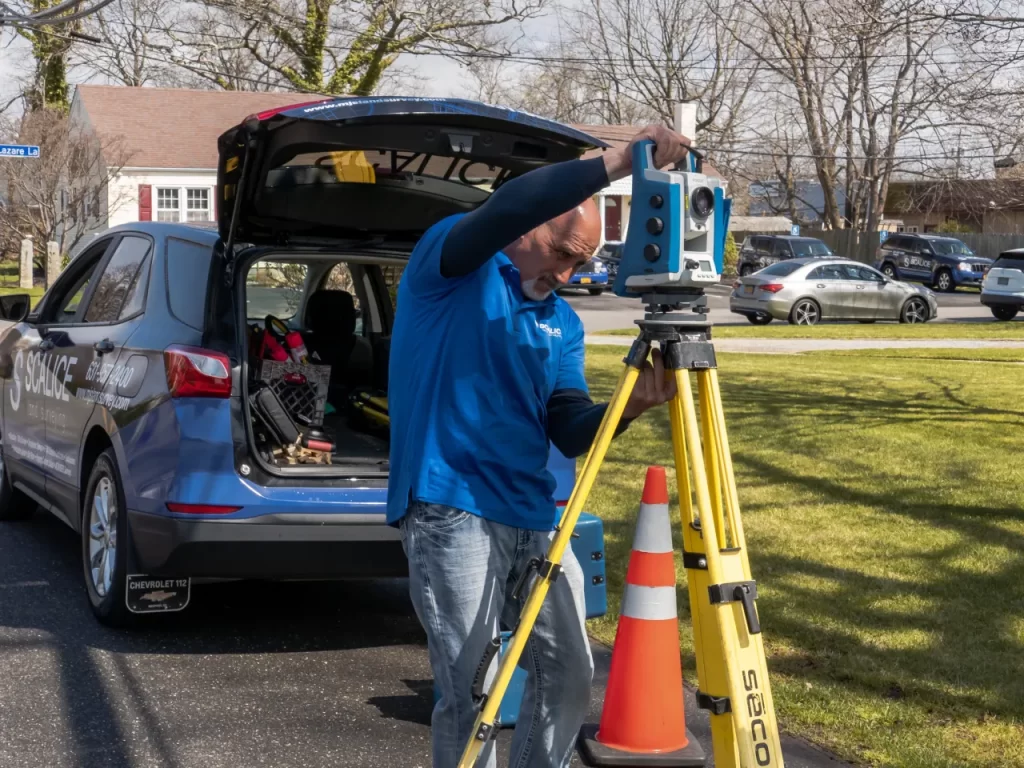
The surveyor will visit your site, use typographical instruments, take photos and use these and other information to make a typographical site plan, with the boundaries and the property lines overlaid on their best view of the space as it is seen now.
Your report will then be made and sent to you for your perusal. It will discuss the findings and given an view on where the boundary line should be.
Your surveyor can only produce what is referred to as an assumed property boundary plan. What this means is that what they determine isn’t immutable truth; it’s an educated opinion created by a professional.
The more information you can give to your surveyor, the more data they can put in and therefore the more accurate their conclusion. Your surveyor can only work with what they have access to.
In the realm of land-owning and the legal boundaries that convey ownership, the cost associated with laying those lines in the sand will usually either sit with you (unless you have agreed to split the cost with your neighbour) or with the seller (if you requested a boundary survey as part of the purchase of a new home).
A land surveyor will be able to tell you where your property line is in law, which could be important in the future if you want to add to or renovate the house or the next buyer wants proof of the physical boundary. We recommend having the Land Registry title plan updated once you have had the survey done to be sure your rights and assets are protected.
The price of the boundary survey will hinge on the intricacy of the issues and when it is you are asking for a survey to be done. Our panel of boundary surveyors need to know what is being disputed or what you want to do. They will access ordnance survey mapping and former registry title plans as part of their research to make the outcome as accurate as possible.
This, added to the land survey cost itself, can add up to, say, £1,000 on average. So, make sure its planned into any renovation plans you are having done.
A boundary survey does not expire, but should regularly be amended as ownership changes, landscapes shift and development is at an all-time high in order to clarify ownership and where the boundaries of a parcel of land end and start.
After you have had a survey done, update the information on the Land Registry title plan so it’s captured for future use.
Typically, your surveyor will spend a few working days completing the survey, as they must visit the site and then write the report, using both what they find on site and desktop research.
Boundary disputes in England and Wales frequently arise when neighbours have a disagreement regarding the exact location of their boundary line that separates their homes. These disagreements can quickly escalate into highly complicated battles oftentimes filled with unpleasantness.
Consequently, these sorts of disputes require a systematic way to be settled. The Boundary Disputes Protocol provides this organized framework, making it the mission of the protocol to contain the problem by efficiently encouraging the early exchange of adequate information and working to come to a resolution short of trial.
Protocol 2 above all sets out the virtues of seeking resolution through alternative dispute resolution methods, all of which – and particularly expert determination, mediation and, perhaps most important of all, negotiation – are cited as being entirely complementary to the way English law has hitherto understood and interpreted property rights.
The benefits of dispute resolution outside the conventional courtroom – we are told this all the time – are manifold. They include not just reducing the emotional and financial toll taken on disputants, but are also said to play an important role in maintaining neighbourhood relations (or at least avoiding spoiling them), in reducing the scope for abuse of rights and in containing costs. The cost of traditional litigation – particularly relative to the sums often in dispute in cases concerning the value of land – can be staggering.
The role of Chartered Surveyors in resolving boundary disputes can not be overstated. Surveyors have the expertise required to provide professional advice on the placement of the boundary, based on physical inspections, review of historical data, and interpretation of legal documents. Surveyors are also able to facilitate a boundary agreement; a document that once drawn and executed by the parties, can be submitted to the Land Registry to legally record the boundary line identified within it. Their expertise ensures that any agreement is based on an expert view, providing a robust foundation for any negotiated settlement.
Entering into property litigation, including boundary disputes, is a major decision that should be undertaken with caution and usually as a last resort. With the intricacies involved and the potential for mounting costs and frayed neighbourly relations, litigation should be pursued only when all other avenues for resolution have been exhausted.
Informal Approach is Unsuccessful: if informal discussion and negotiation, possibly with the help of professionals, fails to bring about resolution, then, particularly if the stake involves a substantial impact on property’s value or use, litigation may be necessary.
Exhausting Alternative Dispute Resolution (ADR): when attempts to resolve the dispute through mediation, negotiation, or expert determination, with the guidance of professional advisers have not resulted in an agreement, then litigation may be necessary. Professional advice from chartered surveyors and solicitors is a good indicator that you have clear legal grounds to take the case to the court if it comes to it.
Claims for Adverse Possession: when a claim for adverse possession has arisen and the matter can not be resolved by another means, litigation may be the appropriate avenue to determine title and boundary disputes.
Protocol Compliance: confirm that all steps of the protocol for boundary disputes are completed including adequate information exchanges and following attempts at ADR resolution. It is only more likely that litigation can be justified when these protocols have preceded the dispute, regardless of whether it has been resolved.
Cost-Benefit Analysis: you must weigh whether the potential benefits (such as preserving your property rights or resolving a bitter boundary dispute that has been going on for years) justify the financial and psychological costs.
Legal Advice: before deciding whether to litigate, it is important to obtain the benefit of comprehensive legal advice. A solicitor who specialises in property disputes can provide you with valuable insights into the prospects of success, the potential costs involved and the overall impact on your property and personal well-being.
To establish the property boundary line is not a simple task; rather, it demands the acquisition of information from historical research, the principle and customary consideration of laws involved to the subject, and the decade long applied professional skills. See general steps as follows:
You may also need: boundary dispute expert witness reports, how close you can build to a boundary and party wall services.