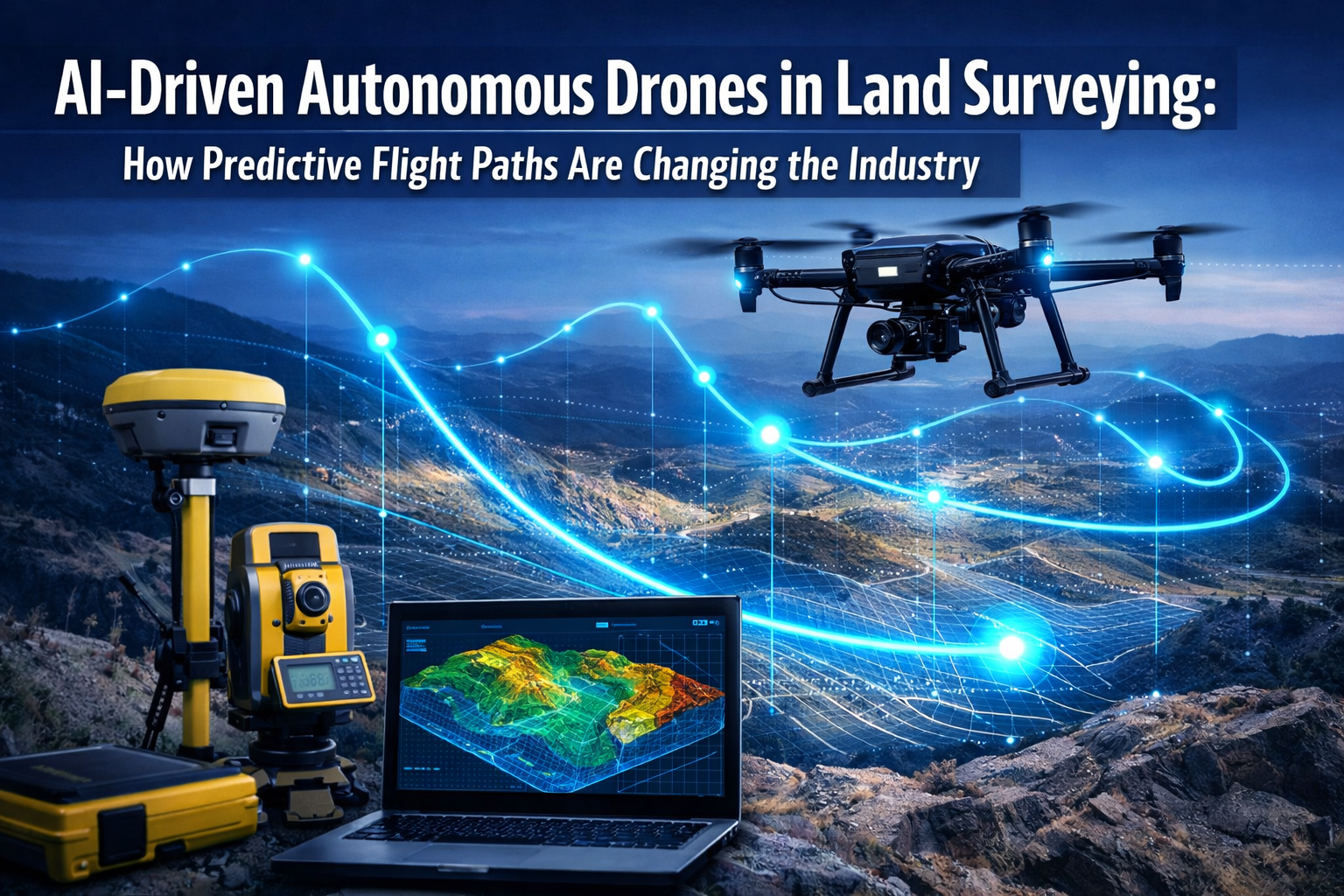
The land surveying industry is experiencing a fundamental transformation in 2026, driven by AI-powered autonomous drones that can predict, plan, and execute complex surveying missions without human intervention. Gone are the days when surveyors needed multiple site visits, extensive ground crews, and weeks of manual data processing. AI-Driven Autonomous Drones in Land Surveying: How Predictive Flight Paths Are Changing the Industry represents more than just technological advancement—it signals a complete reimagining of how professionals capture, analyze, and deliver survey-grade data for large-scale properties.
The introduction of purpose-built platforms like ZenaTech's IQ Quad in January 2026 demonstrates how the industry has moved beyond simple remote-controlled aircraft to sophisticated autonomous systems.[1] These platforms automatically generate optimal flight paths, adjust altitude based on terrain variations, and avoid obstacles in real time—all while maintaining centimeter-level accuracy that meets professional surveying standards.[2] For property owners, developers, and surveying professionals, this means unprecedented efficiency, reduced costs, and faster project timelines.
Key Takeaways
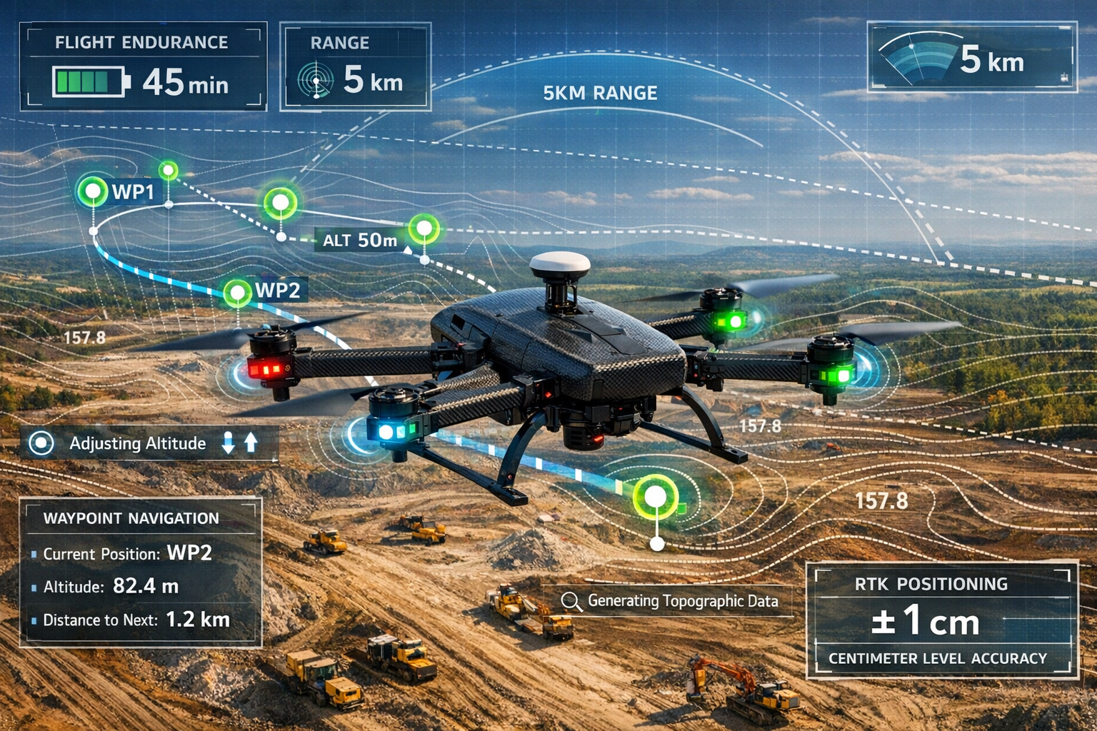
✅ Autonomous drones now deliver 45-minute flight endurance and 5 km operational range, enabling single-flight coverage of hundreds of acres that previously required multiple field crews and extended site access.[1]
✅ Predictive flight path technology automatically adjusts altitude based on terrain and avoids obstacles in real time, eliminating manual intervention and ensuring consistent data quality across entire survey missions.[2]
✅ Centimeter-level accuracy through RTK/PPK GNSS systems meets professional surveying standards, with AI processors validating data during flight to eliminate inconsistencies.[4]
✅ Cloud-based processing automation reduces data analysis from weeks to hours, with captured information automatically uploaded and processed without manual surveyor intervention.[2][4]
✅ Interchangeable sensor systems (4K cameras, LiDAR, thermal, multispectral) enable diverse applications across construction, mining, infrastructure, agriculture, and urban planning sectors.[1]
Understanding AI-Driven Autonomous Drones in Land Surveying: How Predictive Flight Paths Are Changing the Industry
The Evolution from Manual to Autonomous Flight Systems
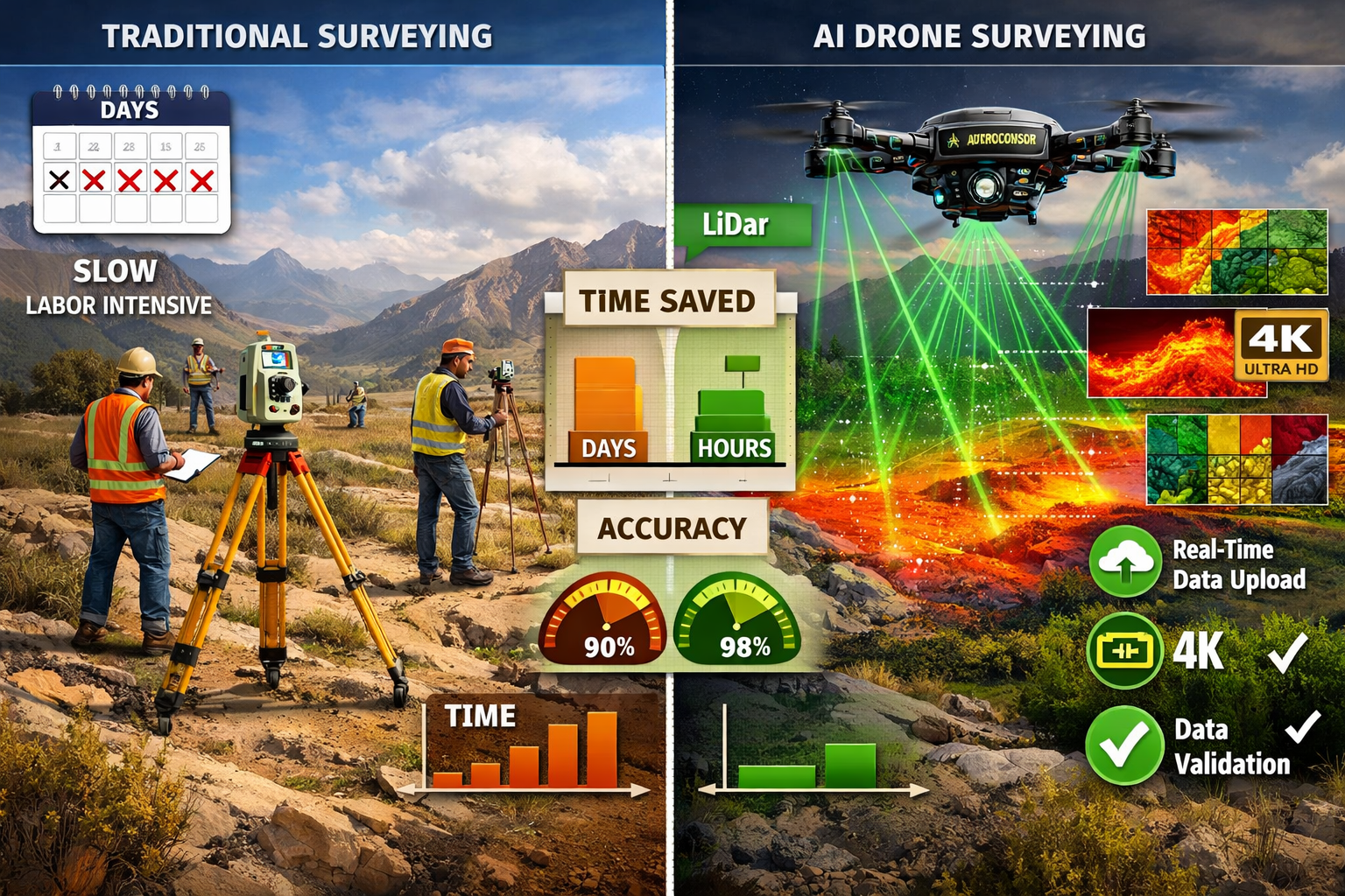
Traditional land surveying required ground-based crews spending days or weeks manually measuring properties using total stations, GPS receivers, and measuring equipment. Even early drone adoption still demanded skilled pilots to manually control flight patterns, maintain consistent altitude, and ensure complete coverage—introducing human error and variability into data collection.
The shift to autonomous systems with predictive capabilities fundamentally changes this paradigm. Modern platforms like the IQ Quad utilize onboard AI processors that analyze terrain data, weather conditions, and mission parameters to automatically generate optimal flight paths before takeoff.[1] During flight, these systems continuously adjust their trajectory, altitude, and speed based on real-time environmental feedback—ensuring consistent data capture without manual pilot intervention.
This autonomous approach delivers several critical advantages:
- Repeatability: Identical flight patterns can be executed across multiple missions, enabling accurate change detection and temporal analysis
- Consistency: Automated altitude adjustments maintain optimal ground sampling distance across varied terrain
- Safety: 360-degree situational awareness and obstacle detection prevent collisions without pilot reaction time delays[1]
- Efficiency: Missions execute faster when systems optimize flight paths for battery life and coverage requirements
Predictive Flight Path Technology: The Core Innovation
The term "predictive" in autonomous drone surveying refers to the system's ability to anticipate and plan for terrain variations, obstacles, and optimal data capture positions before and during flight. Unlike reactive systems that respond to obstacles after detection, predictive algorithms analyze terrain models, satellite imagery, and mission requirements to generate flight plans that proactively avoid known hazards while maximizing data quality.[2]
Key components of predictive flight systems include:
| Component | Function | Benefit |
|---|---|---|
| Terrain Analysis | Pre-flight evaluation of elevation data to plan altitude adjustments | Maintains consistent ground sampling distance across hills and valleys |
| Obstacle Mapping | Integration of known structures, vegetation, and hazards into flight planning | Prevents collisions while minimizing unnecessary altitude increases |
| Coverage Optimization | Algorithm-driven waypoint placement for complete area coverage | Eliminates gaps in data capture while minimizing redundant overlap |
| Battery Management | Predictive calculation of energy requirements based on terrain and weather | Ensures mission completion or automatic return-to-home before power depletion |
| Real-Time Adaptation | Continuous adjustment of planned paths based on actual flight conditions | Compensates for wind, unexpected obstacles, and changing environments |
For professionals conducting drone roof surveys or comprehensive property assessments, these predictive capabilities mean more reliable data collection with fewer failed missions and retakes.
Survey-Grade Positioning: Meeting Professional Standards
The surveying industry maintains strict accuracy requirements that distinguish professional-grade data from recreational mapping. Autonomous drones achieve these standards through advanced GNSS (Global Navigation Satellite System) technology, specifically RTK (Real-Time Kinematic) and PPK (Post-Processed Kinematic) positioning systems that deliver centimeter-level accuracy.[4]
RTK systems receive correction signals from ground-based reference stations during flight, enabling real-time position accuracy of 1-2 centimeters horizontally and 2-3 centimeters vertically. This precision rivals traditional ground-based surveying methods while covering vastly larger areas in significantly less time.
PPK systems record raw GNSS data during flight and apply corrections during post-processing, offering similar accuracy without requiring real-time communication with base stations. This approach proves particularly valuable in remote locations or areas with limited cellular connectivity.
The IQ Quad platform integrates these positioning technologies with onboard AI processors that validate data quality during flight.[1] If the system detects positioning degradation, signal loss, or other accuracy threats, it can automatically adjust flight parameters, pause data collection, or alert operators—preventing the collection of substandard data that would require costly remission flights.
The Technology Behind Autonomous Surveying Platforms
Purpose-Built Hardware for Professional Applications
The January 2026 launch of ZenaTech's IQ Quad represents the industry's shift toward purpose-built autonomous platforms specifically engineered for surveying and mapping applications rather than adapted from recreational or general-purpose drones.[1][7] This design philosophy prioritizes the unique requirements of professional surveying work.
Critical hardware specifications include:
🚁 45-minute flight endurance enabling coverage of large properties in single missions without battery changes[1]
📡 5 km operational range supporting surveys of extensive sites from single takeoff locations[1]
⚖️ 2-3 kg payload capacity accommodating professional survey sensors and equipment[1]
🔧 Carbon fiber airframe with folding arms balancing structural rigidity with field portability[1]
🔋 Autonomous recharging capability through dedicated landing stations for extended multi-flight operations[1]
👁️ 360-degree situational awareness cameras providing complete environmental monitoring during autonomous flight[1]
The platform's VTOL (Vertical Takeoff and Landing) design eliminates the need for runways or launch equipment, enabling deployment directly at survey sites regardless of terrain conditions. This capability proves essential for structural surveys of properties with limited access or challenging topography.
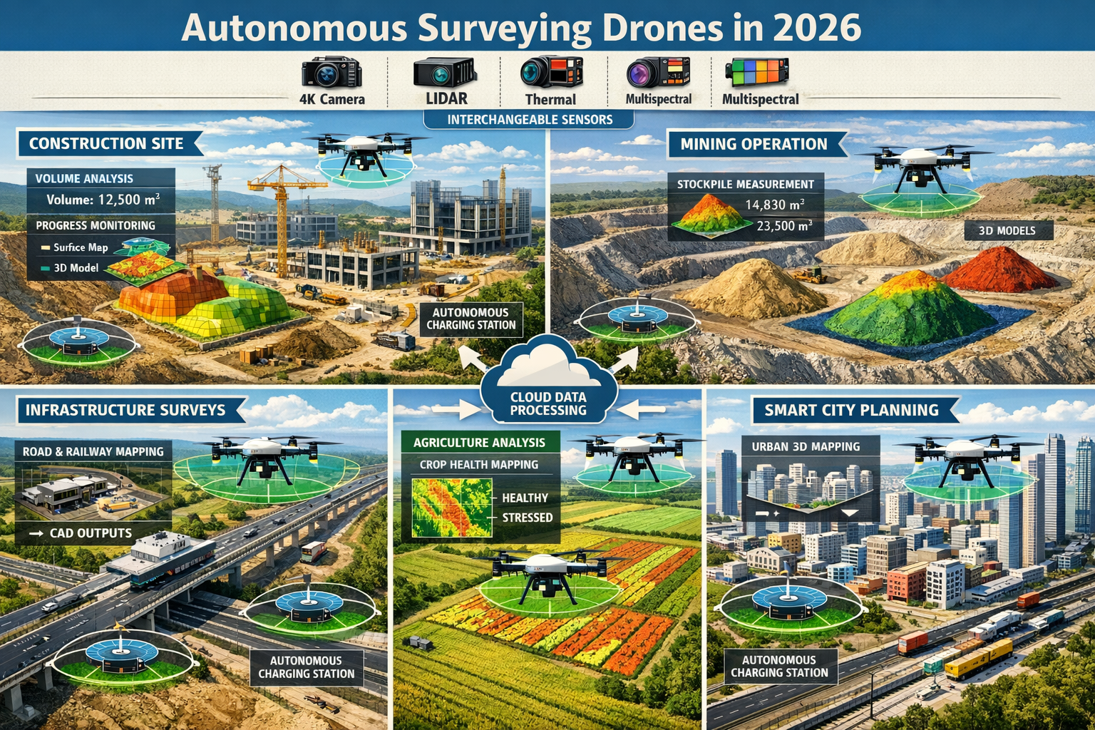
Interchangeable Sensor Systems for Diverse Applications
Professional surveying demands different data types depending on project requirements, environmental conditions, and deliverable specifications. Modern autonomous platforms address this need through modular payload systems that support rapid sensor changes between missions.[1]
Available sensor configurations include:
4K RGB Cameras: High-resolution photogrammetry for orthomosaic generation, 3D modeling, and visual documentation. Ideal for construction progress monitoring, property documentation, and general mapping applications.
LiDAR (Light Detection and Ranging): Laser-based distance measurement penetrating vegetation to capture ground surface beneath tree canopy. Essential for forestry surveys, corridor mapping, and applications requiring bare-earth terrain models.
Thermal Sensors: Infrared imaging detecting temperature variations for applications including roof inspections, solar panel assessment, agricultural crop stress analysis, and infrastructure monitoring.
Multispectral Cameras: Multi-band imaging capturing visible and near-infrared wavelengths for agricultural health assessment, environmental monitoring, and vegetation analysis.[1]
This sensor flexibility enables surveying firms to deploy single platforms across multiple service offerings, reducing equipment investment while expanding capability. A firm conducting boundary surveys might use RGB cameras for property line documentation in the morning, then switch to thermal sensors for roof inspections in the afternoon—maximizing equipment utilization and return on investment.
AI Processing: From Data Capture to Actionable Intelligence
The "intelligence" in AI-driven autonomous drones extends beyond flight control to encompass the entire data processing workflow. Traditional surveying required manual processing of captured imagery through photogrammetry software—a time-consuming process demanding specialized expertise and powerful computing resources.
Modern autonomous systems integrate AI and machine learning algorithms that automate processing workflows previously requiring days or weeks of manual effort.[2][4] Captured data uploads automatically to cloud platforms where algorithms:
- Align and stitch thousands of individual images into seamless orthomosaic maps
- Generate 3D point clouds and surface models from overlapping photography
- Extract measurements, volumes, and contours meeting CAD-ready specifications
- Identify and classify features including buildings, vegetation, water bodies, and infrastructure
- Detect changes between time-series surveys highlighting construction progress or environmental modifications
This automation dramatically reduces the time from data capture to deliverable, enabling faster project timelines and more responsive service delivery. For clients requiring rapid turnaround—such as construction firms needing weekly progress documentation or developers evaluating multiple potential sites—this processing speed provides significant competitive advantage.
Real-World Applications: AI-Driven Autonomous Drones in Land Surveying: How Predictive Flight Paths Are Changing the Industry Across Sectors
Construction: Site Monitoring and Volumetric Analysis
The construction industry has emerged as one of the primary adopters of autonomous drone surveying technology, leveraging predictive flight capabilities for applications ranging from initial site assessment through final as-built documentation.[2]
Pre-construction site analysis benefits from autonomous drones' ability to rapidly survey hundreds of acres, generating accurate topographic models that inform grading plans, drainage design, and earthwork calculations. A single autonomous mission can capture data that previously required multiple survey crews spending days establishing control points and collecting spot elevations.
Progress monitoring throughout construction phases enables project managers to track work completion, verify contractor performance, and identify potential issues before they become costly problems. Autonomous drones executing identical flight paths weekly or monthly provide consistent documentation that clearly highlights changes between survey periods—making progress assessment objective and quantifiable.
Volumetric calculations for earthwork, stockpiles, and material quantities achieve high accuracy through autonomous systems' consistent data capture. The predictive flight algorithms maintain optimal altitude and overlap throughout missions, ensuring complete coverage without gaps that could compromise volume measurements.
For firms providing expert witness reports or construction dispute resolution services, autonomous drone data provides objective, timestamped documentation of site conditions and project progress—valuable evidence in litigation or arbitration proceedings.
Mining and Aggregates: Stockpile Management
Mining operations and aggregate producers require frequent, accurate measurements of stockpile volumes for inventory management, production tracking, and financial reporting. Traditional ground-based surveying of stockpiles proves time-consuming, potentially dangerous, and disruptive to operations.
Autonomous drones address these challenges by surveying stockpiles from above without requiring personnel to climb potentially unstable material piles. The predictive flight systems automatically adjust altitude to maintain safe clearance while optimizing ground sampling distance for accurate volume calculations.
Monthly or weekly autonomous surveys provide operations managers with current inventory data, enabling better production planning and material management. The consistency of autonomous flight paths ensures volume calculations remain comparable across time periods, supporting accurate trend analysis and forecasting.
Infrastructure: Road, Railway, and Utility Corridor Surveys
Linear infrastructure projects—including roads, railways, pipelines, and transmission lines—present unique surveying challenges due to their extensive length and narrow width. Traditional surveying methods require establishing control networks along entire corridors, a time-intensive process complicated by access restrictions, traffic management, and right-of-way limitations.
Autonomous drones with predictive flight capabilities excel at corridor surveys by automatically following linear features while maintaining consistent altitude and overlap. The systems generate flight paths that optimize coverage of narrow corridors while minimizing unnecessary data capture of adjacent areas.
Asset inspection applications combine autonomous flight with specialized sensors to assess infrastructure condition. Thermal cameras detect heat anomalies in electrical transmission equipment, high-resolution RGB cameras document pavement conditions, and LiDAR systems measure vegetation encroachment along railway corridors.
The ability to conduct these inspections without traffic disruption or extensive access arrangements reduces costs while improving safety for inspection personnel. Autonomous systems can survey active roadways, operating railways, and energized transmission lines from safe distances while capturing detailed condition data.
Agriculture: Precision Land and Crop Analysis
Agricultural applications of autonomous drone surveying extend beyond simple field mapping to encompass precision agriculture practices that optimize inputs, maximize yields, and minimize environmental impact.[2]
Land surveys for drainage planning utilize autonomous drones to capture detailed topographic data informing tile drainage design, terracing layouts, and water management infrastructure. The centimeter-level accuracy of RTK-equipped systems supports precise grading specifications that optimize field drainage while minimizing soil erosion.
Crop health monitoring through multispectral sensors identifies stress conditions before they become visible to the naked eye. Autonomous flight systems execute regular monitoring missions throughout growing seasons, with AI algorithms analyzing spectral data to identify areas requiring intervention—enabling targeted application of water, nutrients, or pest control measures.
Yield prediction models incorporate autonomous drone data with historical records and weather information to forecast production volumes, supporting marketing decisions and harvest planning.
Urban Planning: Smart City Mapping and Development
Urban planners and municipal authorities utilize autonomous drone surveying for comprehensive city mapping, development planning, and infrastructure management.[2] The technology's ability to rapidly capture current conditions across extensive urban areas supports data-driven planning decisions.
3D city models generated from autonomous drone surveys provide planners with accurate representations of existing built environments, supporting shadow studies, viewshed analysis, and development impact assessment. The models serve as base data for public engagement, enabling residents to visualize proposed developments in accurate context.
Infrastructure asset management applications track the condition and location of municipal assets including roads, sidewalks, street lighting, and signage. Regular autonomous surveys document asset conditions over time, supporting maintenance planning and budget forecasting.
For professionals conducting dilapidation surveys or condition assessments, autonomous drone data provides comprehensive documentation of property conditions at specific points in time—valuable for lease negotiations, property transfers, or dispute resolution.
Operational Advantages: Reducing Site Visits and Optimizing Workflows
Minimizing Physical Site Access Requirements
One of the most significant operational benefits of AI-driven autonomous drones in land surveying is the dramatic reduction in required site visits and physical access. Traditional surveying methods demanded survey crews spend extended periods on-site, establishing control networks, collecting data points, and verifying coverage—often requiring multiple visits to complete complex projects.
Autonomous systems with predictive flight capabilities enable single-visit data collection for projects that previously required multiple field deployments. The systems' ability to automatically generate comprehensive flight plans, execute missions autonomously, and validate data quality during capture ensures complete coverage without return visits for gap-filling or data verification.
This reduction in site visits delivers multiple benefits:
💰 Lower travel costs and field time reducing overall project expenses
⏱️ Faster project completion enabling quicker turnaround for clients
🔒 Reduced site disruption minimizing impact on ongoing operations
⚡ Improved safety limiting personnel exposure to hazardous environments
For properties with access challenges—including active construction sites, industrial facilities, or environmentally sensitive areas—the ability to conduct comprehensive surveys with minimal ground presence proves particularly valuable.
Extended Coverage in Single Missions
The 45-minute flight endurance of modern autonomous platforms like the IQ Quad enables coverage of hundreds of acres in single missions—a capability that fundamentally changes project economics for large-scale surveys.[1] Traditional ground-based surveying of extensive properties required multiple crews working for days or weeks, with associated costs for personnel, equipment, and site access.
A single autonomous drone mission can now capture data across 200-400 acres depending on required resolution and overlap settings—coverage that would require a ground crew weeks to survey using traditional methods.[4] This dramatic efficiency improvement makes comprehensive surveying economically feasible for applications that previously couldn't justify the cost, including:
- Large agricultural properties requiring regular monitoring
- Extensive development sites needing frequent progress documentation
- Mining operations tracking multiple stockpile locations
- Infrastructure corridors spanning miles of linear distance
The autonomous recharging capability of advanced platforms further extends operational range by enabling multi-battery missions without manual intervention.[1] The drone automatically returns to charging stations between flight segments, enabling coverage of properties exceeding single-battery range without operator involvement.
Data Quality Consistency and Validation
Manual flight operations introduce variability in data quality based on pilot skill, environmental conditions, and human factors including fatigue and distraction. Even experienced pilots may inadvertently vary altitude, speed, or overlap percentages—introducing inconsistencies that complicate data processing and potentially compromise accuracy.
Autonomous systems with AI-driven flight control eliminate this variability by executing flight plans with machine precision. The systems maintain consistent altitude above ground level regardless of terrain variations, achieve exact overlap percentages between image captures, and follow planned flight lines within centimeters—ensuring uniform data quality across entire survey areas.
Perhaps more importantly, onboard AI processors validate data quality during flight rather than discovering problems during post-processing.[4] The systems continuously monitor:
- GNSS positioning accuracy and satellite availability
- Image quality including focus, exposure, and motion blur
- Coverage completeness and overlap adequacy
- Sensor performance and data recording status
If the system detects quality issues during flight, it can automatically adjust parameters, recapture affected areas, or alert operators—preventing the collection of unusable data that would require costly remission flights. This real-time validation ensures that when the drone lands, the captured data meets quality standards for deliverable production.
Implementation Considerations for Surveying Professionals
Integration with Existing Workflows and Standards
Surveying firms considering adoption of AI-driven autonomous drone technology must evaluate how these systems integrate with established workflows, software platforms, and professional standards. Successful implementation requires more than purchasing equipment—it demands thoughtful integration into existing business processes.
Software compatibility represents a critical consideration. Autonomous drone systems should produce outputs compatible with industry-standard platforms including:
- CAD software (AutoCAD Civil 3D, MicroStation) for design integration
- GIS platforms (ArcGIS, QGIS) for spatial analysis and mapping
- BIM (Building Information Modeling) tools for construction coordination
- Surveying software for control network adjustment and quality verification
Most modern platforms support standard data formats including LAS point clouds, GeoTIFF orthomosaics, and DXF/DWG vector files—ensuring compatibility with existing software investments.
Professional standards compliance requires autonomous drone outputs meet accuracy specifications established by surveying regulatory bodies and professional organizations. The centimeter-level positioning accuracy of RTK/PPK-equipped systems generally satisfies requirements for most applications, but firms must verify compliance with specific project standards and local regulations.
For firms offering comprehensive services including structural surveys and building surveys, autonomous drone data complements rather than replaces traditional methods—providing aerial perspectives and large-area coverage that enhance ground-based detailed assessments.
Regulatory Compliance and Certification Requirements
Operating autonomous drones for commercial surveying requires compliance with aviation regulations that vary by jurisdiction but generally include pilot certification, aircraft registration, and operational limitations.
In most regions, commercial drone operations require:
📋 Remote Pilot Certificate demonstrating aeronautical knowledge and regulatory understanding
✈️ Aircraft registration with appropriate aviation authority
📝 Operational authorizations for flights beyond visual line of sight (BVLOS) or in controlled airspace
🔍 Insurance coverage protecting against liability for property damage or personal injury
Autonomous operations may require additional authorizations beyond standard commercial drone permits, particularly for BVLOS flights where the aircraft operates outside the pilot's direct visual observation. Regulatory authorities increasingly recognize the safety benefits of autonomous systems with obstacle detection and situational awareness, but approval processes remain rigorous.
Surveying firms should engage with aviation authorities early in implementation planning to understand specific requirements and approval timelines for intended operations. Some jurisdictions offer streamlined approval processes for professional surveying applications, recognizing the industry's established safety culture and professional standards.
Training and Skill Development
While autonomous systems reduce the piloting skill required for routine operations, successful implementation demands new competencies including:
Mission planning expertise: Understanding how to configure flight parameters, overlap settings, and ground sampling distance for specific project requirements and deliverable specifications.
Data processing proficiency: Operating photogrammetry and point cloud processing software to transform raw captures into usable deliverables including orthomosaics, terrain models, and CAD-ready outputs.
Quality assessment capability: Evaluating data quality, identifying processing artifacts, and verifying accuracy through ground control point comparison and independent verification.
System maintenance knowledge: Performing routine equipment maintenance, troubleshooting technical issues, and managing firmware updates and calibration procedures.
Many surveying professionals find that existing surveying knowledge translates effectively to drone applications—concepts including ground control, coordinate systems, and accuracy assessment apply equally to aerial and ground-based methods. The primary learning curve involves mastering flight operations and photogrammetry processing rather than fundamental surveying principles.
Equipment manufacturers and industry associations offer training programs ranging from basic operation through advanced applications, supporting professional development and certification. Firms should budget for ongoing training investment as technology evolves and new capabilities emerge.
Cost-Benefit Analysis and Return on Investment
The decision to adopt AI-driven autonomous drone technology requires careful financial analysis comparing acquisition and operational costs against efficiency gains and new revenue opportunities.
Initial investment costs include:
- Autonomous drone platform ($15,000-$50,000+ depending on capabilities)
- Professional sensors (LiDAR, multispectral, thermal: $5,000-$100,000+)
- Ground control and RTK base station equipment ($3,000-$15,000)
- Processing software licenses ($1,000-$10,000+ annually)
- Training and certification ($2,000-$5,000 per operator)
- Insurance coverage ($2,000-$10,000+ annually)
Operational cost savings derive from:
- Reduced field time and travel expenses
- Smaller crew requirements for large-area surveys
- Faster project completion enabling higher throughput
- Lower equipment depreciation compared to traditional survey instruments
Revenue enhancement opportunities include:
- New service offerings (progress monitoring, volumetric analysis, thermal inspection)
- Larger project capacity through improved efficiency
- Premium pricing for rapid turnaround and comprehensive documentation
- Expanded market reach to projects previously uneconomical
Most surveying firms implementing autonomous drone technology report payback periods of 6-18 months depending on utilization rates and application mix. Firms with regular large-area surveying requirements typically achieve faster returns than those with primarily small-site or detailed building survey work.
For practices offering diverse services including schedule of condition reports and specific defect assessments, drone technology adds valuable documentation capabilities that enhance service quality while improving efficiency.
Future Developments: What's Next for Autonomous Surveying Technology
Enhanced Autonomy and Multi-Drone Coordination
Current autonomous platforms operate as single independent units executing predefined missions, but emerging developments point toward enhanced autonomy including multi-drone coordination and adaptive mission planning.[8]
Swarm technology will enable multiple drones to coordinate coverage of extensive areas, with individual units automatically dividing survey regions, avoiding conflicts, and optimizing collective efficiency. This capability will dramatically reduce survey time for very large properties while maintaining data consistency across the entire area.
Adaptive mission planning will allow systems to modify flight plans during execution based on discovered conditions—adjusting coverage density in areas of complex terrain, extending missions when interesting features are detected, or prioritizing specific regions based on real-time analysis.
Autonomous feature extraction will progress beyond current automated processing to include intelligent feature identification and measurement—with systems automatically detecting and measuring buildings, vegetation, infrastructure, and other features of interest without manual processing intervention.
Integration with Digital Twin and BIM Workflows
The construction and infrastructure industries' adoption of digital twin technology—virtual replicas of physical assets updated continuously with real-world data—creates expanding opportunities for autonomous drone surveying.[2]
Autonomous drones will serve as primary data sources for digital twin creation and updating, conducting regular surveys that feed current condition data into virtual models. The predictive flight capabilities ensure consistent data capture enabling accurate change detection and temporal analysis.
BIM (Building Information Modeling) integration will enable autonomous survey data to automatically update design models with as-built conditions, supporting construction verification and facility management applications. The combination of autonomous data capture with AI-driven processing will enable near-real-time model updating without manual intervention.
Advanced Sensor Development and Data Fusion
Sensor technology continues advancing with smaller, lighter, and more capable systems expanding autonomous drone applications.[6]
Miniaturized LiDAR systems now approaching the size and weight of traditional cameras will make high-density point cloud capture accessible on smaller platforms, expanding the range of properties and applications suitable for LiDAR surveying.
Hyperspectral sensors capturing dozens or hundreds of spectral bands will enable advanced material identification, environmental monitoring, and agricultural analysis—applications currently limited by sensor size and cost.
Data fusion algorithms will combine multiple sensor types in single missions, automatically integrating RGB imagery, LiDAR point clouds, thermal data, and multispectral information into unified datasets that provide more comprehensive property characterization than any single sensor type.
Regulatory Evolution and Expanded Operational Authority
Aviation regulatory authorities worldwide are developing frameworks for expanded autonomous operations including routine beyond visual line of sight (BVLOS) flights and operations over people—currently restricted in most jurisdictions.[8]
These regulatory advances will enable autonomous drones to survey larger areas from single takeoff points, conduct corridor surveys along extensive linear infrastructure, and operate in urban environments with greater flexibility. The safety record of autonomous systems with advanced obstacle detection and situational awareness supports regulatory confidence in expanded operational authority.
Remote identification requirements being implemented in many jurisdictions will enable authorities and property owners to identify operating drones, supporting accountability while enabling more flexible operations in populated areas.
Conclusion: Embracing the Autonomous Revolution in Land Surveying
AI-Driven Autonomous Drones in Land Surveying: How Predictive Flight Paths Are Changing the Industry represents far more than incremental technological improvement—it constitutes a fundamental transformation in how surveying professionals capture, process, and deliver spatial data. The combination of predictive flight planning, centimeter-level positioning accuracy, automated data validation, and AI-driven processing creates capabilities that were simply impossible with previous technology generations.
The operational advantages are compelling: single-visit data collection for properties requiring multiple field crews using traditional methods, hundreds of acres surveyed in hours rather than weeks, and automated processing reducing deliverable turnaround from weeks to days. These efficiency gains translate directly to improved project economics, faster client service, and expanded market opportunities.
For surveying firms, the question is no longer whether to adopt autonomous drone technology but how quickly to implement and how effectively to integrate these capabilities into service offerings. Early adopters gain competitive advantages through expanded capacity, enhanced service quality, and differentiated capabilities that set them apart in increasingly competitive markets.
Property owners, developers, and project managers benefit from more comprehensive data, faster turnaround, and lower costs compared to traditional surveying approaches. The technology enables applications—including frequent construction progress monitoring, regular stockpile measurement, and comprehensive infrastructure condition assessment—that were previously uneconomical using conventional methods.
Actionable Next Steps
For Surveying Professionals:
- Evaluate current project mix to identify applications where autonomous drone technology delivers maximum value—prioritizing large-area surveys, regular monitoring requirements, and difficult-access properties
- Research available platforms comparing capabilities, sensor compatibility, and integration with existing software workflows
- Engage with regulatory authorities to understand certification requirements and operational limitations in your jurisdiction
- Develop implementation plan including equipment acquisition, training investment, insurance coverage, and workflow integration
- Start with pilot projects to develop operational expertise and demonstrate capabilities before full-scale deployment
For Property Owners and Developers:
- Discuss autonomous drone capabilities with surveying service providers to understand how the technology can benefit your projects
- Consider regular monitoring programs for construction sites, large properties, or infrastructure assets where frequent data updates provide management value
- Evaluate comprehensive documentation for properties where traditional surveying proved cost-prohibitive
- Explore specialized applications including thermal inspections, volumetric analysis, or environmental monitoring enabled by interchangeable sensor systems
For Industry Stakeholders:
- Support regulatory frameworks that enable safe autonomous operations while maintaining public safety and privacy protections
- Invest in training programs developing workforce skills for emerging autonomous drone applications
- Promote professional standards ensuring autonomous drone surveying maintains accuracy and quality expectations
- Encourage technology development advancing capabilities, reducing costs, and expanding accessibility
The autonomous revolution in land surveying is accelerating in 2026, driven by platforms like the IQ Quad and supported by advancing AI, sensor technology, and regulatory frameworks. Organizations that embrace these capabilities position themselves at the forefront of industry transformation, while those that delay risk competitive disadvantage in an increasingly technology-driven market.
Whether you're conducting drone roof surveys, comprehensive boundary surveys, or large-scale development site assessments, AI-driven autonomous drones with predictive flight paths offer unprecedented capabilities for efficient, accurate, and comprehensive spatial data collection. The future of land surveying is autonomous, intelligent, and already arriving.
References
[1] Autonomous Vtol Ai Drone Launched For Surveying Mapping Applications – https://www.unmannedsystemstechnology.com/2026/01/autonomous-vtol-ai-drone-launched-for-surveying-mapping-applications/
[2] Self Flying Uavs For Survey Mapping Are Redefining Aerial Intelligence – https://www.dronitech.com/self-flying-uavs-for-survey-mapping-are-redefining-aerial-intelligence/
[3] Ai Drones For Surveying Enhancing Land Mapping Precision And Efficiency – https://www.arcsurveyors.com/ai-drones-for-surveying-enhancing-land-mapping-precision-and-efficiency/
[4] How Drones Are Transforming Surveying Mapping And Inspection In 2026 – https://www.uavsphere.com/post/how-drones-are-transforming-surveying-mapping-and-inspection-in-2026
[5] Autonomous Drones In Land Surveying Capturing Large Properties With Single Flights In 2026 – https://nottinghillsurveyors.com/blog/autonomous-drones-in-land-surveying-capturing-large-properties-with-single-flights-in-2026
[6] roboticstomorrow – https://www.roboticstomorrow.com/article/2026/01/automated-multispectral-terrain-mapping-using-drones-and-robotics/26021
[7] Another New Drone From Zenatech – https://dronelife.com/2026/01/22/another-new-drone-from-zenatech/
[8] 2026 Drone Revolution Ai Autonomy Transforms Industries Worldwide – https://droneworld.co.in/2026-drone-revolution-ai-autonomy-transforms-industries-worldwide/