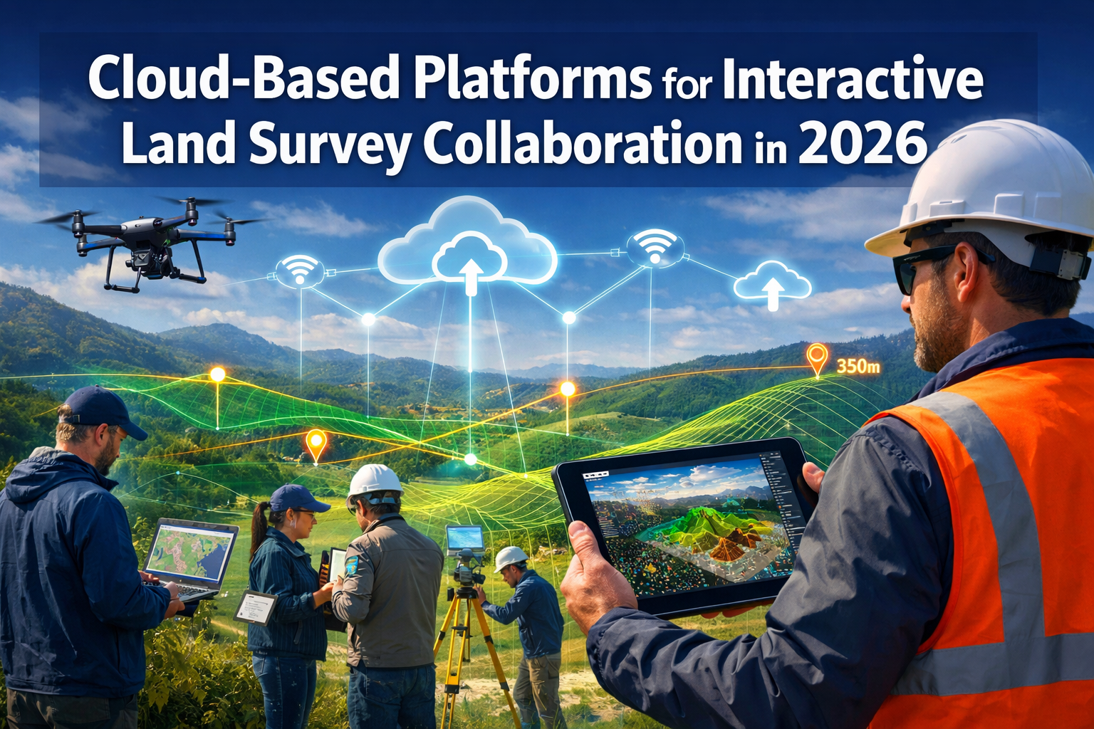
The land surveying profession stands at a pivotal transformation point. Gone are the days when surveyors delivered static PDF documents that clients struggled to interpret and stakeholders found difficult to collaborate on. In 2026, Cloud-Based Platforms for Interactive Land Survey Collaboration have fundamentally changed how surveying data is captured, processed, shared, and utilized across multi-stakeholder projects. Engineers, architects, developers, and clients now access real-time 3D visualizations directly in their browsers, make annotations simultaneously, and track revisions instantly—all without downloading specialized software or waiting for updated file versions to arrive via email.
This shift represents more than just technological advancement; it marks a complete reimagining of how surveying professionals deliver value. Interactive cloud platforms enable unprecedented collaboration, dramatically reduce project timelines, and provide decision-makers with intuitive tools that transform complex spatial data into actionable insights.
Key Takeaways
- 🌐 Real-time browser-based 3D visualization has replaced static PDF deliverables, allowing all project stakeholders to access interactive survey models instantly without specialized software
- ⚡ Processing speed improvements now enable complex surveying jobs that previously required multiple software products and over a day of processing to be completed in minutes using integrated cloud platforms
- 🔄 Automated revision syncing ensures all team members—engineers, architects, and clients—always work with the most current survey data, eliminating version control confusion
- 🏗️ Digital twin deliverables provide commercial development clients with advanced decision-making tools including slope erosion projections, water flow simulations, and infrastructure stress testing within single interactive models
- 📊 Consumption-based pricing models similar to AWS and Google Cloud make enterprise-grade surveying platforms accessible to firms of all sizes with flexible scaling options
Understanding Cloud-Based Platforms for Interactive Land Survey Collaboration in 2026
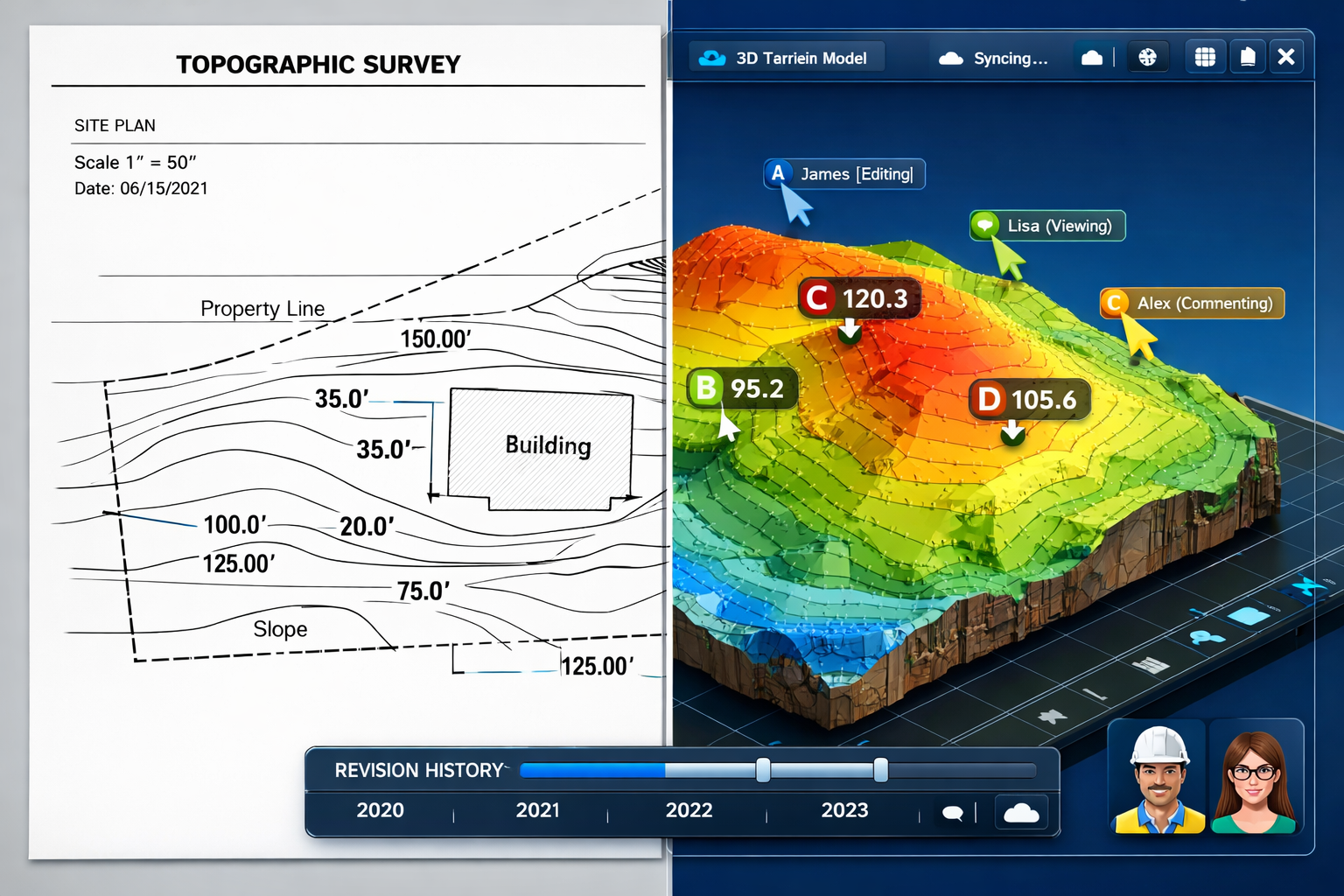
The Evolution from Static to Interactive Deliverables
Traditional land surveying workflows relied heavily on static deliverables—printed plats, PDF documents, and CAD files that required specialized software to view. These formats created significant barriers to collaboration. When an engineer needed to review boundary measurements, an architect wanted to understand existing topography, or a client sought to visualize proposed development impacts, they faced technical hurdles and communication delays.
Cloud-Based Platforms for Interactive Land Survey Collaboration in 2026 have eliminated these barriers entirely. Modern platforms now provide interactive 3D visualization in browsers as the standard deliverable format, replacing static documents with real-time, interactive models that clients can access instantly[1]. This transformation enables stakeholders to:
- Rotate and zoom through 3D terrain models using only a web browser
- Click on specific points to retrieve exact measurements and elevation data
- Toggle between different data layers (topography, utilities, boundaries, vegetation)
- Add annotations and comments that all team members see immediately
- Compare multiple survey iterations side-by-side in real time
The impact on project efficiency is substantial. Chartered surveyors working on complex developments report that interactive platforms reduce the number of clarification meetings by 40-60% because stakeholders can explore survey data independently and arrive at meetings with informed questions rather than basic orientation needs.
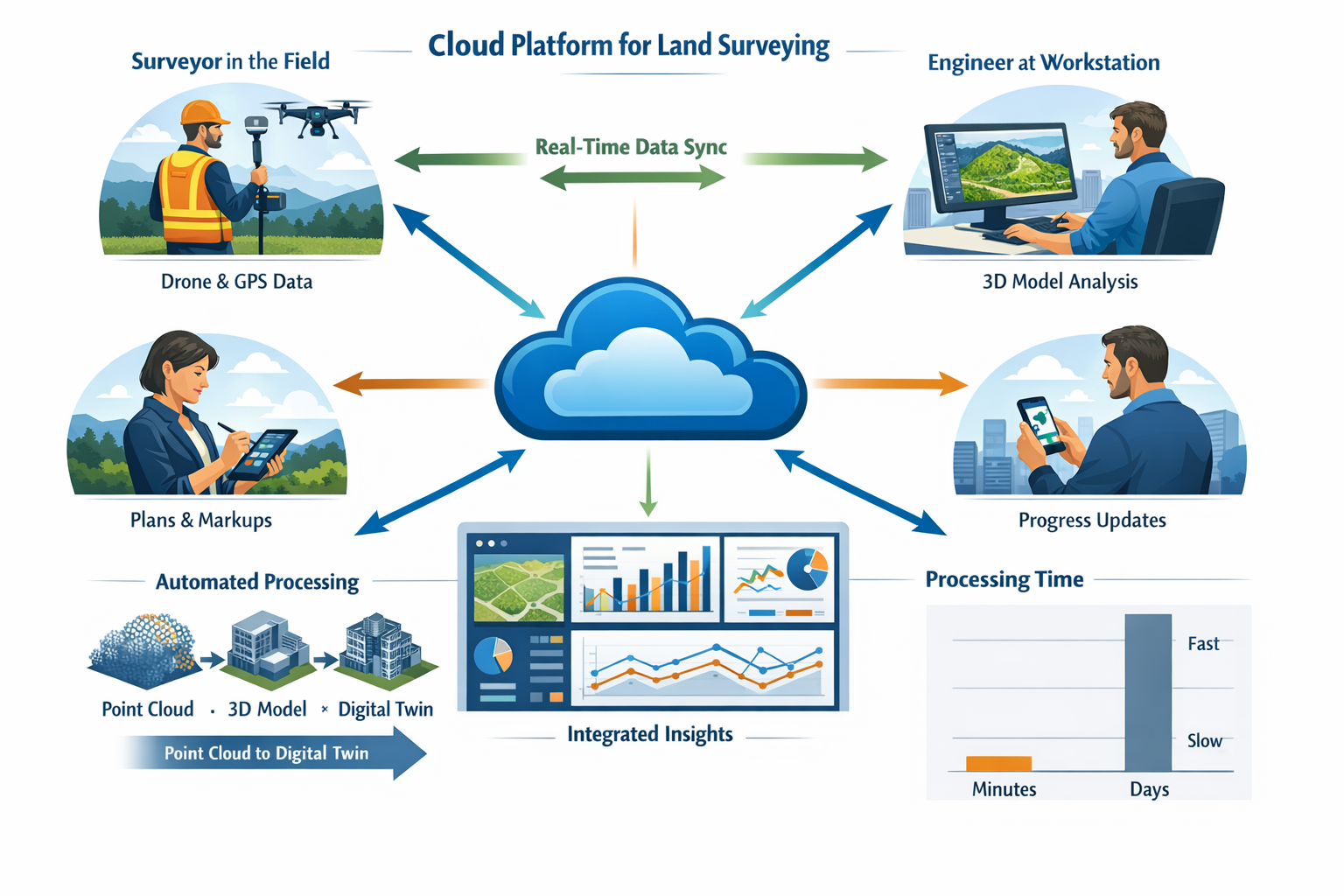
Core Components of Modern Cloud Survey Platforms
Today's leading cloud-based surveying platforms integrate multiple capabilities within unified environments. Pointerra3D's Digital Surveyor Bundle exemplifies this comprehensive approach, providing a single platform for storing, visualizing, managing, sharing, and processing all spatial data types—including point clouds, imagery, orthophotos, 3D models, and vector base maps[2].
Essential platform components include:
| Component | Function | Stakeholder Benefit |
|---|---|---|
| Cloud Storage | Centralized repository for all survey data types | Single source of truth accessible 24/7 |
| 3D Visualization Engine | Browser-based rendering of point clouds and models | No specialized software required |
| Collaboration Tools | Real-time commenting, markup, and revision tracking | Simultaneous multi-user workflows |
| Automated Processing | AI-driven classification, feature extraction, analytics | Reduced manual labor, faster turnaround |
| Integration APIs | Connections to CAD, BIM, GIS, and project management tools | Seamless data flow across project ecosystem |
| Access Controls | Role-based permissions and security protocols | Appropriate data access for each stakeholder |
These integrated environments eliminate the traditional workflow friction of exporting data from one specialized tool, converting formats, transferring files, and importing into another application. For boundary surveys and complex property assessments, this integration means surveyors can move from field data capture to client-ready interactive deliverable in a fraction of the time previously required.
Processing Speed and Efficiency Gains
The performance improvements delivered by cloud-based platforms are transformative. Processing speed improvements are dramatic: traditionally complex jobs requiring multiple software products, multiple file transfers, and over a day of combined processing can now be completed in minutes using modern cloud platforms[2].
This acceleration stems from several technological advances:
🚀 Distributed Cloud Computing: Rather than relying on a single workstation's processing power, cloud platforms distribute computational tasks across multiple servers simultaneously, enabling parallel processing of massive point cloud datasets.
🤖 Automated Workflows: Machine learning algorithms now handle tasks that previously required manual intervention—classifying ground points, identifying vegetation, extracting building features, and detecting utilities—with minimal human oversight[2].
📡 Edge Processing: Some platforms process initial data filtering and compression at the edge (on survey equipment or local devices) before uploading to the cloud, reducing bandwidth requirements and accelerating overall workflows.
For surveying firms conducting drone roof surveys or large-scale topographic mapping, these efficiency gains translate directly to competitive advantages. Firms can accept more projects, deliver faster turnarounds, and allocate skilled surveyors to high-value analytical work rather than routine data processing tasks.
Real-Time Collaboration Features Transforming Multi-Stakeholder Projects
Simultaneous Access and Revision Syncing
One of the most significant advantages of Cloud-Based Platforms for Interactive Land Survey Collaboration in 2026 is the elimination of version control nightmares. Traditional workflows created confusion when multiple stakeholders worked with different versions of survey documents, leading to costly errors and miscommunication.
Cloud platforms enable simultaneous 3D visualization, real-time revision syncing, and integrated communication with engineers and architects[1]. When a surveyor updates boundary measurements based on additional field verification, those changes propagate instantly to all authorized users. The platform maintains a complete revision history, allowing stakeholders to:
- See exactly when changes were made and by whom
- Compare any two versions side-by-side with visual difference highlighting
- Revert to previous versions if needed
- Receive automatic notifications when relevant data updates occur
This real-time synchronization proves especially valuable for projects involving commercial property surveyors working with development teams. When site conditions change or design modifications require updated survey data, the entire team accesses current information immediately rather than waiting for email distributions and manual file updates.
Integrated Communication and Annotation Tools
Beyond simply viewing survey data, modern cloud platforms facilitate rich communication directly within the spatial context. Stakeholders can:
💬 Add Georeferenced Comments: Click any location on the 3D model to attach questions, observations, or instructions that appear exactly where relevant
✏️ Create Visual Markups: Draw lines, shapes, and annotations directly on survey visualizations to highlight areas of concern or proposed modifications
📸 Attach Supporting Documentation: Link photographs, specification documents, or reference materials to specific survey locations
🔔 Tag Team Members: Mention specific individuals in comments to ensure they receive notifications about issues requiring their attention
📊 Track Resolution Status: Mark issues as open, in progress, or resolved, creating an auditable trail of project communication
These integrated communication tools prove particularly valuable for projects requiring coordination between multiple specialist surveyors. For instance, when boundary dispute resolution requires input from both land surveyors and legal experts, the ability to annotate specific boundary lines with relevant case law references or historical documentation creates clarity that email threads and separate document repositories cannot match.
Multi-Device Accessibility and Field Integration
Seamless cloud accessibility from multiple device types and locations is now standard, allowing in-field access to data whenever needed and eliminating the need for hard drive shipping through instant web links[2]. This accessibility transforms how surveying teams operate:
📱 Mobile Field Access: Surveyors in the field use tablets or smartphones to access the complete project database, verify previous measurements, or upload new observations immediately
💻 Desktop Analysis: Engineers and architects use full-featured desktop interfaces for detailed analysis, complex measurements, and integration with CAD/BIM workflows
🖥️ Client Presentations: Project stakeholders view simplified, presentation-focused interfaces on any device, with complex technical details hidden but accessible when needed
⌚ Real-Time Monitoring: Project managers receive dashboard views on any device, tracking survey progress, data quality metrics, and team productivity
This multi-device flexibility enables new workflows that were impractical with traditional surveying approaches. When conducting structural surveys, surveyors can compare current conditions against baseline data while still on-site, identifying discrepancies immediately rather than discovering them days later during office processing.
Advanced Capabilities: Digital Twins and Automated Analytics
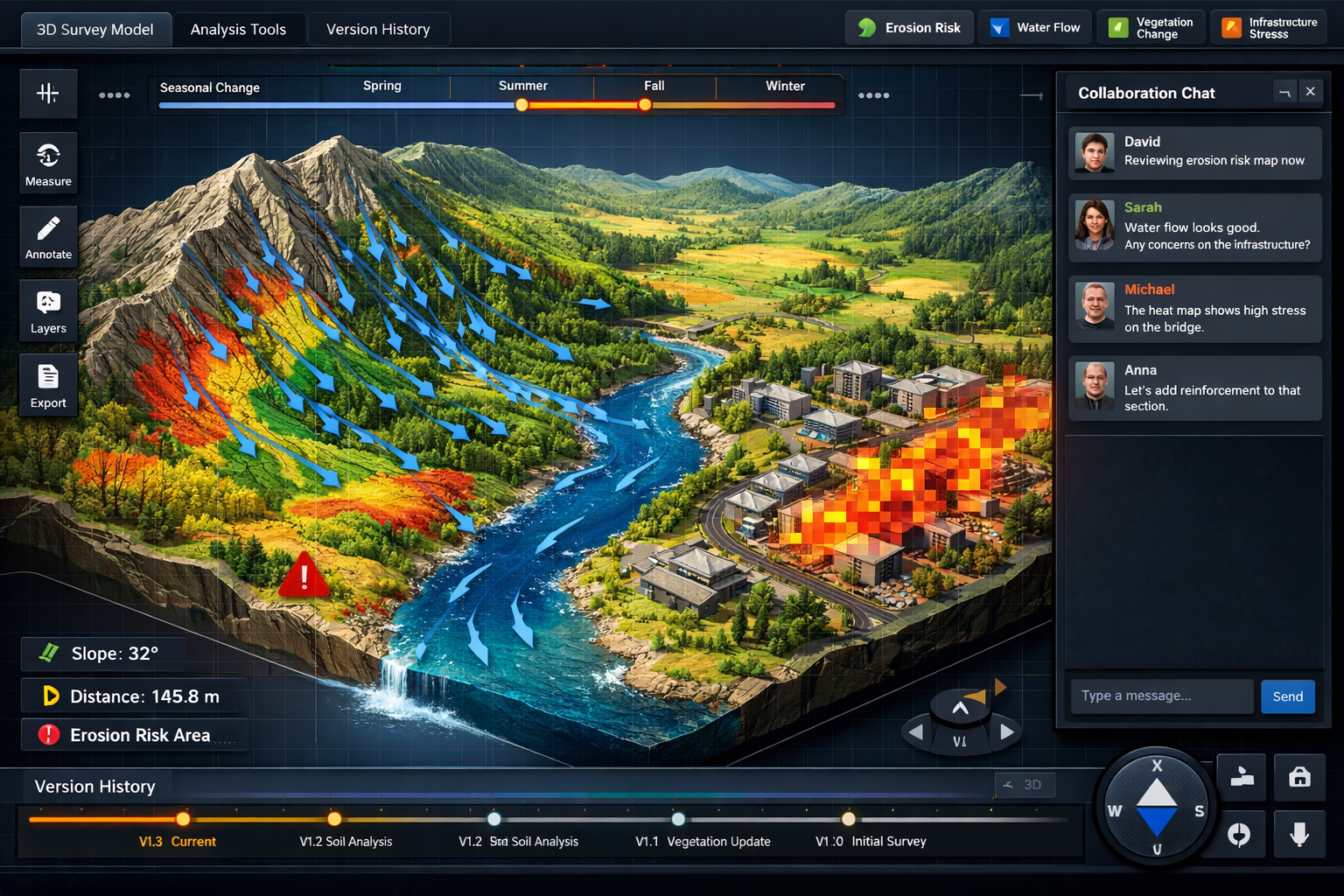
From Traditional Plats to Interactive Digital Twins
The most transformative application of Cloud-Based Platforms for Interactive Land Survey Collaboration in 2026 is the delivery of comprehensive digital twins rather than simple survey plats. Digital-twin deliverables are increasingly provided by surveying firms for commercial development clients, allowing deeper decision-making tools than traditional plats alone[1].
These digital twins incorporate multiple data layers and analytical capabilities:
🌊 Water Flow Simulations: Model how precipitation moves across terrain under various storm scenarios, identifying potential flooding risks and optimal drainage solutions
⛰️ Slope Erosion Projections: Analyze slope stability over time, predicting erosion patterns and identifying areas requiring stabilization before development
🌳 Vegetation Pattern Changes: Track vegetation coverage changes over multiple survey periods, supporting environmental impact assessments and landscape planning
🏗️ Infrastructure Stress Testing: Model how proposed structures interact with existing terrain, utilities, and environmental conditions, identifying potential conflicts before construction begins
All these capabilities exist within single interactive models[1], eliminating the need to switch between separate analysis tools or reconcile data from different sources. For expert surveyors advising on complex developments, this integration enables comprehensive site analysis that would have been prohibitively time-consuming using traditional methods.
Automated Classification and Feature Extraction
Automated analytics capabilities now include digital twin creation, automated classification, feature extraction, LiDAR calibration, risk analysis, predictive insights, and photogrammetric processing—all within the same common data environment, eliminating the need for multiple standalone tools[2].
Machine learning algorithms trained on millions of survey datasets can now automatically:
- Classify point clouds into ground, vegetation, buildings, vehicles, utilities, and other categories with 95%+ accuracy
- Extract building footprints and roof geometries from aerial survey data without manual tracing
- Identify utility locations from ground-penetrating radar and electromagnetic survey data
- Detect changes between survey iterations, highlighting new construction, demolition, or landscape modifications
- Generate contour lines and elevation models with appropriate intervals for project scale
- Calculate volumes for cut-and-fill operations, stockpile measurements, and earthwork planning
These automated capabilities don't eliminate the need for professional surveyor oversight—they amplify surveyor productivity by handling routine tasks and flagging anomalies that require expert judgment. When conducting subsidence surveys, automated change detection can identify millimeter-level elevation changes across thousands of measurement points, directing the surveyor's attention to areas requiring detailed investigation.
Predictive Analytics and Risk Assessment
Beyond describing current conditions, advanced cloud platforms now provide predictive analytics that help stakeholders understand future scenarios. These capabilities leverage historical survey data, environmental models, and machine learning to:
📈 Trend Analysis: Identify patterns in repeated surveys (settlement rates, erosion progression, vegetation encroachment) and project future conditions
⚠️ Risk Scoring: Automatically flag areas with elevated risk based on slope angles, soil conditions, proximity to water features, or other factors
🎯 Optimal Placement Recommendations: Suggest ideal locations for structures, utilities, or landscape features based on comprehensive site analysis
💰 Cost Impact Modeling: Estimate how different site preparation approaches affect project budgets based on terrain characteristics
🌍 Environmental Impact Prediction: Model how development scenarios affect drainage patterns, vegetation, and other environmental factors
These predictive capabilities transform surveys from historical records into forward-looking planning tools. Development teams make more informed decisions, reduce costly surprises during construction, and optimize designs for site-specific conditions.
Pricing Models and Accessibility for Firms of All Sizes
Consumption-Based Pricing Structures
One barrier to cloud platform adoption has been eliminated through flexible pricing models. The Processing Units (PUs) consumption-based model offers flexible pricing with tiers designed for different user profiles[2]:
🔬 Explorer Tier (50 PUs): Designed for small projects, occasional users, or firms testing cloud workflows before full commitment. Suitable for individual property surveys, small-scale topographic mapping, or periodic monitoring projects.
🔄 Adopter Tier (100 PUs): Targeted at regular users and monitoring programs requiring consistent but moderate processing capacity. Appropriate for firms conducting multiple surveys monthly or managing ongoing monitoring contracts.
🏢 Pro Tier (500 PUs): Built for enterprise operations with high-volume processing needs, large project portfolios, or firms serving as data hubs for multi-stakeholder developments.
This model mirrors AWS and Google Cloud's familiar, scalable approach[2], making it intuitive for firms already using cloud services in other aspects of their operations. Importantly, the consumption-based structure means firms pay only for actual usage rather than maintaining expensive software licenses and hardware that sit idle between projects.
Cost-Benefit Analysis for Surveying Firms
When evaluating cloud platform adoption, surveying firms should consider both direct cost savings and revenue enhancement opportunities:
Direct Cost Reductions:
- Eliminate expensive workstation hardware purchases and upgrades
- Reduce IT infrastructure maintenance and support costs
- Minimize software licensing fees for multiple standalone applications
- Decrease data storage and backup infrastructure expenses
- Lower labor costs through automated processing workflows
Revenue Enhancement Opportunities:
- Accept more projects with faster turnaround capabilities
- Offer premium digital twin deliverables at higher price points
- Expand service offerings to include monitoring and analytics
- Improve client retention through superior collaboration experiences
- Reduce rework and liability exposure through better quality control
For established chartered surveyors in London and surrounding areas, the transition to cloud platforms typically achieves positive ROI within 6-12 months when factoring in both cost savings and revenue growth.
Scalability for Growing Practices
Cloud platforms provide unprecedented scalability advantages for surveying practices experiencing growth. Traditional workflows required significant capital investment in hardware and software before taking on larger projects. Cloud platforms eliminate this barrier:
📊 Elastic Capacity: Scale processing capacity up for large projects and down during slower periods, paying only for what you use
👥 Team Expansion: Add new team members and provide instant access to all project data without hardware procurement or software installation delays
🌍 Geographic Expansion: Serve clients in new regions without establishing physical offices or duplicating data infrastructure
🤝 Subcontractor Collaboration: Grant temporary access to specialist subcontractors for specific project components without permanent licensing costs
📚 Archive Access: Maintain searchable access to historical projects without expensive local storage infrastructure
This scalability proves especially valuable for firms serving diverse markets—from residential property surveys to large commercial developments—where project sizes and complexity vary significantly.
Integration with Existing AEC Workflows and Technologies
Drone Surveying and Automated Data Capture
Fully-integrated drone surveying workflows combine high-accuracy drones and cloud-based software, enabling interactive 3D surveys that replace traditional 2D drawings[3]. Modern platforms seamlessly incorporate data from:
🚁 Photogrammetry Drones: Consumer and professional UAVs capturing overlapping imagery for 3D reconstruction
📡 LiDAR-Equipped Drones: Advanced systems providing direct 3D point cloud capture with vegetation penetration
📍 Ground Control Points: Automated processing of GCPs and AeroPoints for survey-grade accuracy
🎥 Oblique Imagery: Multi-angle photography for building facade documentation and visual context
Automated data processing reduces manual labor and increases efficiency through cloud-based software that handles data capture and processing with minimal human intervention[3]. Surveyors upload raw drone data directly from the field, and the platform automatically:
- Aligns and registers images
- Generates point clouds and 3D models
- Applies ground control corrections
- Classifies terrain features
- Produces orthophotos and elevation models
- Creates interactive deliverables ready for client access
This automation transforms drone surveying from a specialist service requiring extensive post-processing expertise into a routine tool accessible to all surveying professionals.
BIM and CAD Integration
Cloud surveying platforms don't exist in isolation—they integrate seamlessly with the broader Architecture, Engineering, and Construction (AEC) technology ecosystem. Enhanced interoperability standards are being accelerated by construction technology vendors including Trimble, with expected expansion of workflows and integrations between construction technology ecosystems to allow seamless project data sharing regardless of software deployed[5].
Key integration capabilities include:
📐 Direct CAD Export: Export survey data in native CAD formats (DWG, DXF) with appropriate layering and annotation
🏗️ BIM Coordination: Import survey point clouds directly into Revit, ArchiCAD, and other BIM platforms for existing conditions modeling
🗺️ GIS Connectivity: Push survey data to ArcGIS, QGIS, and other GIS platforms for broader spatial analysis
📋 Project Management Links: Connect survey milestones and deliverables to Procore, PlanGrid, and other construction management systems
🔄 Two-Way Synchronization: Update survey data based on design changes and vice versa, maintaining coordination throughout project lifecycle
This interoperability ensures that survey data flows efficiently to all stakeholders who need it, in formats they can immediately use within their existing workflows.
Real-Time Construction Monitoring and Documentation
Beyond initial site surveys, cloud platforms enable ongoing construction monitoring that provides value throughout the project lifecycle. Real-time documentation and collaboration now enables surveyors to document conditions, visually track progress, and collaborate on solutions in real time, enhanced by AI and machine learning[5].
Construction monitoring applications include:
📏 As-Built Verification: Compare actual construction against design intent, identifying deviations early when corrections are less costly
📊 Progress Tracking: Document construction progress visually and quantitatively, supporting payment applications and schedule management
⚠️ Quality Control: Identify construction defects, dimensional errors, or material placement issues before they're concealed by subsequent work
🔍 Safety Monitoring: Track excavation depths, slope stability, and other safety-critical conditions throughout construction
📸 Visual Documentation: Maintain timestamped photographic records of all construction phases for liability protection and dispute resolution
For projects involving schedule of dilapidations or other condition documentation requirements, cloud platforms provide indisputable records accessible to all authorized parties.
Security, Data Ownership, and Compliance Considerations
Data Security and Access Controls
When adopting Cloud-Based Platforms for Interactive Land Survey Collaboration in 2026, surveying firms and their clients rightfully prioritize data security. Leading platforms implement enterprise-grade security measures:
🔐 Encryption Standards:
- Data encrypted in transit using TLS 1.3 or higher
- Data encrypted at rest using AES-256 or equivalent
- End-to-end encryption options for highly sensitive projects
👤 Authentication and Access:
- Multi-factor authentication (MFA) required for all users
- Role-based access controls limiting data visibility by stakeholder type
- Single sign-on (SSO) integration with corporate identity systems
- Detailed audit logs tracking all data access and modifications
🏢 Infrastructure Security:
- SOC 2 Type II compliance for platform operations
- Regular third-party security audits and penetration testing
- Redundant data centers with geographic distribution
- Automated backup and disaster recovery protocols
📜 Regulatory Compliance:
- GDPR compliance for projects involving EU stakeholders
- Industry-specific standards (ISO 19650 for BIM, etc.)
- Data residency options to meet jurisdictional requirements
These security measures often exceed what individual surveying firms can implement with on-premises infrastructure, making cloud platforms more secure than traditional approaches.
Data Ownership and Portability
A critical consideration when selecting cloud platforms is ensuring clear data ownership and avoiding vendor lock-in:
📄 Ownership Clarity: Contracts should explicitly state that the surveying firm and/or client retains complete ownership of all survey data, with the platform provider acting only as a service provider.
💾 Export Capabilities: Platforms should support export in standard, non-proprietary formats (LAS/LAZ for point clouds, GeoTIFF for imagery, DXF/DWG for vectors) enabling migration to alternative platforms if needed.
🔓 No Hostage Data: Avoid platforms that store data in proprietary formats accessible only through their software, creating dependency that limits future flexibility.
⏱️ Post-Subscription Access: Understand what happens to data when subscriptions end—reputable providers allow reasonable time for data export and don't immediately delete project archives.
📋 Metadata Preservation: Ensure exported data includes complete metadata (coordinate systems, accuracy specifications, processing parameters) needed for future use.
Surveying firms should carefully review service agreements and select providers with transparent, client-friendly data ownership policies.
Professional Liability and Quality Assurance
Cloud platforms introduce new considerations for professional liability and quality assurance:
✅ Validation Responsibilities: While platforms automate many processing tasks, professional surveyors remain responsible for validating outputs and ensuring deliverables meet project requirements and professional standards.
📊 Quality Control Workflows: Implement systematic QC procedures reviewing automated outputs before client delivery, documenting validation steps for liability protection.
🎓 Training Requirements: Ensure all team members receive adequate training on platform capabilities and limitations, understanding when manual intervention or expert judgment is required.
📝 Documentation Standards: Maintain clear records of processing parameters, algorithms used, and any manual adjustments made, supporting defensibility if deliverables are questioned.
⚖️ Insurance Considerations: Consult with professional liability insurance carriers about cloud platform use, ensuring coverage extends to technology-assisted workflows.
Professional surveying organizations continue developing best practice guidelines for cloud platform use, helping practitioners navigate these evolving considerations responsibly.
Future Trends and Emerging Capabilities
Artificial Intelligence and Machine Learning Advancements
The integration of AI and machine learning into cloud surveying platforms is accelerating rapidly. Real-time point cloud generation is becoming more accessible and affordable, with LiDAR systems becoming less expensive and more attainable for most surveyor types[4]. Beyond current automated classification capabilities, emerging AI applications include:
🧠 Intelligent Anomaly Detection: AI systems that identify unusual patterns requiring surveyor attention—unexpected elevation changes, potential utility conflicts, or data quality issues
🔮 Predictive Maintenance: For monitoring applications, AI that predicts infrastructure failures before they occur based on subtle changes in survey data over time
🗣️ Natural Language Interfaces: Query survey data using conversational language ("Show me all slopes steeper than 15 degrees within 100 meters of the proposed building") rather than complex technical commands
📊 Automated Report Generation: AI that produces narrative survey reports describing site conditions, highlighting key findings, and flagging items requiring attention
🎯 Design Optimization: AI that suggests optimal site layouts based on topography, utilities, environmental constraints, and project requirements
These AI capabilities will further amplify surveyor productivity, enabling professionals to focus on high-value judgment and client advisory roles while AI handles routine analytical tasks.
Extended Reality (XR) Visualization
While browser-based 3D visualization represents a massive improvement over static PDFs, emerging extended reality technologies will provide even more immersive collaboration experiences:
🥽 Virtual Reality (VR) Site Visits: Stakeholders don VR headsets to "walk" survey sites remotely, experiencing terrain and spatial relationships at full scale
📱 Augmented Reality (AR) Field Overlay: Surveyors and construction teams use AR-enabled tablets or glasses to see design intent overlaid on actual site conditions in real-time
🏢 Mixed Reality (MR) Design Reviews: Teams collaborate in shared virtual spaces where survey data, design models, and stakeholders from multiple locations interact simultaneously
🎮 Gamified Exploration: Client-friendly interfaces that make survey data exploration intuitive and engaging, increasing stakeholder understanding and participation
These XR technologies are transitioning from experimental to practical, with several cloud platforms already offering VR/AR viewing options alongside traditional browser interfaces.
Sustainability and Environmental Monitoring
Cloud platforms increasingly support sustainability objectives and environmental monitoring requirements:
🌱 Carbon Footprint Tracking: Calculate and report the carbon impact of surveying activities (travel, equipment operation) and site development scenarios
🦎 Biodiversity Monitoring: Track vegetation coverage, habitat changes, and wildlife corridor preservation using repeated survey data
💧 Water Resource Management: Model groundwater impacts, stormwater management effectiveness, and watershed protection measures
♻️ Circular Economy Support: Document existing structures and materials for deconstruction planning, enabling material reuse rather than demolition waste
📈 Sustainability Reporting: Generate data supporting LEED certification, BREEAM assessment, and other green building standards
As environmental regulations strengthen and stakeholders prioritize sustainability, these capabilities will transition from differentiators to requirements.
Conclusion: Embracing the Cloud Collaboration Revolution
The transformation from static PDF deliverables to Cloud-Based Platforms for Interactive Land Survey Collaboration in 2026 represents one of the most significant advances in surveying practice in decades. The benefits are clear and compelling:
For Surveyors:
- Dramatically reduced processing time through automation
- Elimination of repetitive manual tasks
- Ability to serve more clients with existing resources
- Premium service offerings commanding higher fees
- Reduced liability through better quality control and documentation
For Engineers and Architects:
- Instant access to current survey data without file transfers
- Ability to explore site conditions interactively rather than interpreting static drawings
- Seamless integration with CAD and BIM workflows
- Real-time collaboration reducing coordination meetings
- Confidence that all team members work from identical data
For Clients and Developers:
- Intuitive visualization requiring no specialized training
- Deeper understanding of site opportunities and constraints
- Faster project timelines from survey to design to construction
- Better-informed decisions through digital twin analytics
- Reduced risk of costly surprises during construction
Actionable Next Steps
For surveying firms ready to embrace cloud collaboration platforms:
-
Evaluate Current Workflows: Document time spent on data processing, file management, client communication, and revision coordination—these represent areas where cloud platforms deliver immediate efficiency gains.
-
Start with Pilot Projects: Select 2-3 upcoming projects representing different scales and complexity levels to test cloud platform workflows before full practice-wide adoption.
-
Prioritize Client Communication: Educate clients about interactive deliverable benefits early in project discussions, positioning cloud collaboration as a value-added service rather than an internal technology change.
-
Invest in Team Training: Ensure all team members receive comprehensive platform training, understanding both technical capabilities and best practices for client collaboration.
-
Review Insurance and Contracts: Update professional liability insurance, service agreements, and data ownership provisions to address cloud platform use appropriately.
-
Establish Quality Control Protocols: Develop systematic QC procedures for validating automated processing outputs before client delivery, maintaining professional standards.
-
Monitor ROI Metrics: Track processing time savings, project turnaround improvements, client satisfaction scores, and revenue per surveyor to quantify cloud platform value.
The surveying profession's future is collaborative, interactive, and cloud-based. Firms that embrace these platforms position themselves as technology leaders, deliver superior client experiences, and build sustainable competitive advantages. Those that delay adoption risk being perceived as outdated providers of commodity services rather than valued advisors leveraging cutting-edge tools to deliver exceptional insights.
The question is no longer whether to adopt Cloud-Based Platforms for Interactive Land Survey Collaboration—it's how quickly your firm can implement these transformative tools to serve clients better, empower your team, and thrive in the evolving surveying landscape of 2026 and beyond.
References
[1] Future Land Surveying 2026 – https://haller-blanchard.com/future-land-surveying-2026/
[2] Transforming The Future Of Survey Mapping – https://www.geoweeknews.com/news/transforming-the-future-of-survey-mapping
[3] Land Surveying Propelled Into The Future With Ai And Drones – https://resource-erectors.com/land-surveying-propelled-into-the-future-with-ai-and-drones/
[4] The Future Of Land Surveying Technology And Upcoming Trends In 2026 – https://metricop.com/blogs/land-surveying/the-future-of-land-surveying-technology-and-upcoming-trends-in-2026
[5] Doubling Down On Digital – https://amerisurv.com/2026/02/01/doubling-down-on-digital/
[6] How Ai Is Changing The Role Of The Surveyor In Aec – https://www.gim-international.com/content/article/how-ai-is-changing-the-role-of-the-surveyor-in-aec