The property surveying industry stands at a critical crossroads in 2026. Traditional workflows—characterized by fragmented communication, isolated data silos, and endless email chains—are giving way to a revolutionary approach that promises to transform how surveyors, developers, and regulators collaborate. Common Data Environments in Property Surveying: Unifying Stakeholders for Faster Approvals represents more than just a technological upgrade; it's a fundamental reimagining of how spatial information flows through construction and development projects.
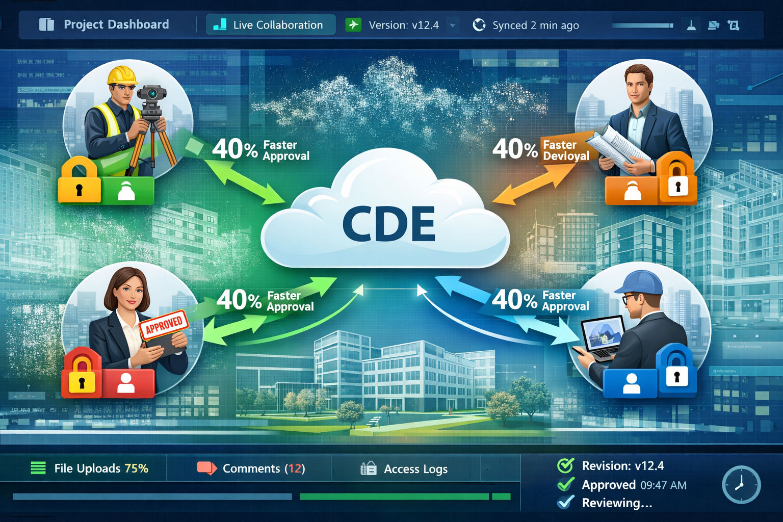
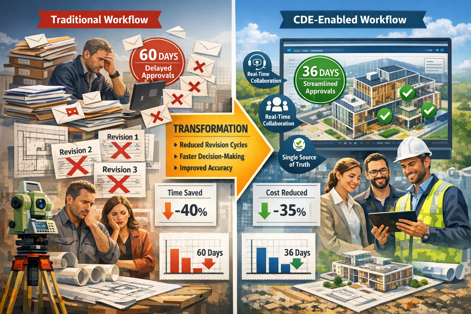
Imagine cutting revision cycles by 40% while simultaneously improving accuracy and stakeholder satisfaction. This isn't a distant aspiration—it's the measurable reality that cloud-based common data environments (CDEs) are delivering to forward-thinking surveying firms today. By enabling real-time data sharing among all project participants, these platforms are eliminating the bottlenecks that have plagued property development for decades.
Key Takeaways
✅ Common Data Environments reduce revision cycles by up to 40% by providing real-time access to survey data, eliminating version control issues and communication delays that traditionally slow project approvals.
✅ CDEs transform surveyors from data providers to strategic partners by enabling continuous collaboration throughout project lifecycles rather than delivering isolated static reports.
✅ Cloud platforms create a unified source of truth that connects surveyors, developers, architects, engineers, and regulatory authorities around consistent, up-to-date project information.
✅ Proper setup and security protocols are essential for maximizing CDE benefits while protecting sensitive property data and maintaining compliance with industry regulations.
✅ Visualization-driven workflows within CDEs enable faster decision-making by allowing stakeholders to interact with 3D models and spatial data rather than interpreting traditional 2D plans.
Understanding Common Data Environments in Property Surveying
What Are Common Data Environments?
A Common Data Environment (CDE) is a centralized digital platform where all project information—from initial survey data to final as-built documentation—is created, shared, reviewed, and approved. In the context of property surveying, CDEs serve a dual purpose: they function both as delivery platforms for survey outputs and as collaboration tools that integrate spatial information with broader project data.[1]
The construction industry's evolution into a data-driven sector has accelerated CDE adoption at an unprecedented rate.[1] What was once considered cutting-edge technology has rapidly become standard practice, fundamentally changing how professionals approach project delivery.
The Shift from Static to Dynamic Survey Contributions
Traditional surveying workflows produced isolated static deliverables—printed plans, PDF reports, or standalone point cloud files that existed separately from other project information. This approach created several critical problems:
- 📊 Version confusion when multiple stakeholders worked with different iterations of survey data
- ⏰ Communication delays as questions and clarifications traveled through email chains
- 🔄 Redundant work when surveyors needed to recreate outputs in different formats for various stakeholders
- 🚫 Limited context as survey data existed independently from design models and construction plans
Common Data Environments fundamentally address these challenges by enabling surveyors to contribute to dynamic, shared environments where their work directly informs real-time decision-making across project teams.[1] Instead of delivering a final product and stepping away, surveyors remain engaged as collaborative partners throughout the project lifecycle.
When conducting structural surveys or boundary surveys, modern chartered surveyors can upload findings directly to CDEs where architects, engineers, and developers can immediately access and integrate this information into their workflows.
Key Components of Surveying-Focused CDEs
Effective Common Data Environments for property surveying typically include these essential components:
| Component | Function | Benefit |
|---|---|---|
| Cloud Storage | Centralized repository for all survey data, models, and documentation | Eliminates version control issues and ensures consistent access |
| Collaboration Tools | Real-time commenting, markup, and review capabilities | Reduces communication delays and clarification cycles |
| Visualization Platform | 3D model viewing and comparison tools | Enables non-technical stakeholders to understand spatial data |
| Integration Capabilities | Connections to BIM software, CAD tools, and survey equipment | Creates seamless data flow from field to final deliverable |
| Access Controls | Role-based permissions and security protocols | Protects sensitive data while enabling appropriate sharing |
| Audit Trails | Complete history of changes, approvals, and communications | Provides accountability and regulatory compliance documentation |
How Common Data Environments Accelerate Approvals in Property Surveying
Creating a Unified Source of Truth
One of the most powerful aspects of CDEs is their ability to unify teams around a single source of truth. Platforms like Trimble Connect demonstrate how real-time collaboration and simultaneous integration of data from multiple sources eliminate the confusion that traditionally slowed approval processes.[4]
When all stakeholders—from surveyors conducting homebuyer reports to regulatory authorities reviewing compliance—access the same current information, several transformative benefits emerge:
🎯 Reduced Misunderstandings: Everyone interprets the same data rather than working from different versions or outdated information.
⚡ Faster Clarifications: Questions can be addressed directly within the platform with visual markup tools rather than through lengthy email exchanges.
✅ Streamlined Approvals: Regulators can review survey data in context with design models, understanding how proposed work relates to existing conditions.
💰 Cost Savings: Fewer revision cycles and reduced rework translate directly to lower project costs and improved profitability.
Real-World Impact: Measurable Improvements
Construction projects implementing CDEs have demonstrated measurable improvements in efficiency and decision-making speed. In one notable tunneling project, survey teams used a common data environment to compare as-built cross-sections with design models in real-time. This approach shortened decision-making timelines and increased confidence that work met specifications.[4]
"CDEs support faster, more informed decision-making by providing comprehensive project visibility across all integrated data sources." – Trimble Construction Industry Insights[4]
For property surveying specifically, this translates to:
- 40% reduction in revision cycles as stakeholders identify and address issues earlier in the process
- Faster regulatory approvals when authorities can access complete, contextualized information
- Improved accuracy as surveyors can immediately verify their data against design intent
- Enhanced client satisfaction through transparency and real-time project visibility
Visualization-Driven Workflows Transform Stakeholder Communication
Perhaps the most significant shift enabled by Common Data Environments is the move toward visualization-driven workflows. Design conversations increasingly occur within 3D models rather than traditional 2D plans, enabling quicker iterations, faster workflows, and stronger alignment across design and construction phases.[1]
This transformation particularly benefits property surveying because:
- Non-technical stakeholders can understand spatial relationships and survey findings without specialized training
- Regulatory reviewers can visualize proposed changes in context with existing structures
- Developers and investors can make informed decisions based on visual representations rather than interpreting technical drawings
- Architects and engineers can immediately see how survey data impacts their design assumptions
When conducting roof surveys or subsidence investigations, surveyors can present findings within interactive 3D environments that clearly communicate issues and recommended solutions to all project participants.
Setting Up Common Data Environments for Property Surveying Success
Step 1: Platform Selection and Requirements Assessment
Implementing a CDE begins with selecting the right platform for your surveying practice and typical project types. Consider these critical factors:
Technical Requirements:
- ✔️ Compatibility with your existing survey equipment and software
- ✔️ Support for relevant file formats (point clouds, CAD drawings, BIM models)
- ✔️ Integration capabilities with industry-standard tools (AutoCAD, Revit, survey processing software)
- ✔️ Mobile access for field teams to upload data directly from site
Collaboration Features:
- ✔️ Real-time commenting and markup tools
- ✔️ Automated notification systems for updates and approvals
- ✔️ Version control with complete audit trails
- ✔️ Multi-party video conferencing integrated with project data
Scalability Considerations:
- ✔️ Storage capacity for large point cloud files and high-resolution imagery
- ✔️ Performance with complex 3D models and multiple simultaneous users
- ✔️ Pricing structure that aligns with your project volume and team size
- ✔️ Ability to customize workflows for different survey types
For practices offering diverse services—from schedules of condition to dilapidations surveys—ensure your chosen platform can accommodate varying data types and stakeholder requirements.
Step 2: Establishing Information Architecture
A well-organized information architecture is essential for CDE effectiveness. Create a consistent folder structure that all team members and external stakeholders can navigate intuitively:
Project Root/
├── 01_Survey_Data/
│   ├── Field_Notes/
│   ├── Point_Clouds/
│   ├── Photographs/
│   └── Raw_Measurements/
├── 02_Processed_Deliverables/
│   ├── CAD_Drawings/
│   ├── 3D_Models/
│   ├── Reports/
│   └── Visualizations/
├── 03_Design_Integration/
│   ├── Architectural_Models/
│   ├── Structural_Models/
│   └── Clash_Detection/
├── 04_Approvals_Documentation/
│   ├── Regulatory_Submissions/
│   ├── Review_Comments/
│   └── Approved_Versions/
└── 05_Project_Management/
    ├── Correspondence/
    ├── Meeting_Notes/
    └── Change_Orders/
Implement naming conventions that clearly identify:
- Document type
- Date created
- Version number
- Responsible party
- Status (draft, review, approved)
Example: 2026-03-15_BoundarySurvey_v3_KingstonSurveyors_APPROVED.dwg
Step 3: Configuring Access Controls and Permissions
Security and appropriate information sharing require carefully configured role-based access controls:
| Role | Access Level | Typical Permissions |
|---|---|---|
| Survey Team Lead | Full administrative | Create, edit, delete, approve all survey data |
| Field Surveyors | Contributor | Upload field data, add comments, view all survey information |
| Client/Developer | Reviewer | View all data, add comments, cannot edit original files |
| Architects/Engineers | Collaborator | View survey data, upload design models, comment on integration |
| Regulatory Authorities | Limited reviewer | View specific approved submissions, download approved documents |
| External Consultants | Project-specific | Access limited to relevant project sections only |
Configure notification settings to ensure stakeholders receive timely updates without overwhelming them with irrelevant alerts. For example:
- Survey team receives notifications when new design models are uploaded
- Clients receive alerts when survey deliverables are ready for review
- Regulatory authorities are notified only when formal submissions are made
- All parties are alerted to critical issues flagged during clash detection
Step 4: Integration with Survey Equipment and Software
Modern survey equipment increasingly offers direct integration with cloud platforms, eliminating manual data transfer steps that introduce errors and delays:
Total Stations and GNSS Receivers:
- Configure equipment to automatically upload measurements to CDE upon returning to office
- Enable field teams to verify data completeness before leaving site
- Create automated workflows that trigger processing routines when new data arrives
Laser Scanners and Photogrammetry:
- Set up direct cloud processing for point cloud registration and cleaning
- Configure automatic generation of deliverable formats (E57, RCP, LAS)
- Enable progressive upload of large datasets to minimize downtime
Survey Processing Software:
- Establish two-way synchronization between desktop applications and CDE
- Configure automated export of finalized CAD drawings and models
- Enable version tracking that links processed deliverables to source data
For practices conducting RICS valuations or building surveys, integration ensures all supporting documentation and measurements flow seamlessly into final reports.
Step 5: Establishing Workflows and Protocols
Document clear standard operating procedures for how your team will use the CDE:
Data Upload Protocols:
- Field teams upload raw data within 24 hours of site visit
- Data undergoes quality check before being marked "ready for processing"
- Processed deliverables are placed in review folder with notification to stakeholders
- Feedback is collected through platform commenting (not email)
- Final approved versions are moved to approved folder with locked editing
Communication Guidelines:
- All project-related discussions occur within the CDE (not email)
- Comments include @mentions to direct questions to specific individuals
- Critical issues are flagged with priority levels
- Responses to queries are required within specified timeframes (e.g., 48 hours for standard, 4 hours for critical)
Review and Approval Processes:
- Define who has authority to approve different document types
- Establish required review periods for various stakeholders
- Configure automated reminders for pending approvals
- Document approval decisions with reasons for any rejections
Security Best Practices for Common Data Environments in Property Surveying
Understanding Security Risks in Surveying Data
Property survey data contains sensitive information that requires robust protection:
- 🏠 Property ownership details and boundary information
- 💰 Valuation data that could impact market transactions
- 🔐 Security vulnerabilities revealed through detailed building surveys
- 📋 Regulatory compliance information subject to privacy requirements
- 🏗️ Proprietary design information from architects and developers
A security breach could expose your practice to significant liability, damage client relationships, and violate data protection regulations like GDPR.
Essential Security Measures
1. Encryption Standards
Ensure your CDE platform implements:
- Encryption in transit (TLS 1.3 or higher) for all data transfers
- Encryption at rest (AES-256) for stored files
- End-to-end encryption for sensitive communications
- Encrypted backups with geographically distributed storage
2. Authentication and Access Control
Implement multi-factor authentication (MFA) for all users accessing the CDE. This typically combines:
- Something you know (password)
- Something you have (mobile device for authentication code)
- Something you are (biometric verification for highly sensitive projects)
Configure session management to:
- Automatically log out inactive users after 30 minutes
- Require re-authentication for sensitive operations
- Limit simultaneous sessions per user account
- Track and alert on unusual access patterns
3. Data Loss Prevention
Protect against accidental or malicious data loss:
- ✅ Automated backups with multiple retention periods (daily for 30 days, weekly for 1 year)
- ✅ Version history that allows recovery of previous file versions
- ✅ Soft deletion with recovery period before permanent removal
- ✅ Download restrictions for external stakeholders when appropriate
- ✅ Watermarking of sensitive documents to track distribution
4. Audit and Compliance
Maintain comprehensive audit trails that record:
- Who accessed which files and when
- What changes were made to documents
- When files were downloaded or shared externally
- All permission changes and user account modifications
- Failed login attempts and security alerts
Configure compliance monitoring for:
- GDPR requirements for personal data handling
- Industry-specific regulations (building regulations, planning requirements)
- Client-specific security requirements
- Professional indemnity insurance conditions
5. User Training and Awareness
Technology alone cannot ensure security. Implement regular training covering:
- Recognizing phishing attempts targeting survey data
- Proper password management and MFA usage
- Appropriate sharing of access credentials (never!)
- Identifying and reporting security incidents
- Understanding data classification and handling requirements
Incident Response Planning
Develop a security incident response plan that defines:
- Detection: How security incidents are identified and reported
- Containment: Immediate steps to limit damage (disable accounts, revoke access)
- Investigation: Process for determining scope and impact of breach
- Notification: Requirements for informing affected parties and authorities
- Recovery: Steps to restore normal operations and prevent recurrence
- Review: Post-incident analysis to improve security measures
Expanding Service Offerings Through CDE Capabilities
From Data Provider to Strategic Partner
Common data environments and visualization tools elevate surveyors from data providers to collaborative partners embedded in project teams from conception through long-term asset management.[1] This strategic repositioning opens significant opportunities for expanding service offerings and increasing project value.
Traditional Survey Services:
- Boundary survey → Deliver CAD drawing
- Building survey → Provide written report with photographs
- Topographic survey → Supply point cloud and contour drawing
CDE-Enhanced Service Offerings:
- Boundary survey → Interactive 3D visualization with stakeholder collaboration throughout dispute resolution
- Building survey → Dynamic digital twin updated throughout renovation project with real-time defect tracking
- Topographic survey → Integrated site model supporting design iterations and automated earthwork calculations
Visualization-Ready Data Deliverables
Surveying firms that deliver survey data optimized for 3D visualization and BIM integration position themselves as essential strategic partners in collaborative workflows rather than simply vendors of measurement services.[1]
Expanded Deliverable Portfolio:
📊 Interactive 3D Models
- Navigate through point cloud data with measurement tools
- Compare as-built conditions with design intent
- Identify clashes and coordination issues automatically
🎨 Visualization-Ready Meshes
- Textured 3D models suitable for client presentations
- Virtual reality walkthroughs of existing conditions
- Photorealistic renderings for planning applications
🏗️ BIM-Integrated Survey Data
- Point clouds registered to BIM coordinate systems
- Automated extraction of building elements from scan data
- As-built BIM models created from survey information
💡 Digital Twin Foundations
- Baseline spatial data for ongoing asset management
- Integration points for IoT sensors and monitoring systems
- Framework for lifecycle facility management
Supporting Digital Handoffs and Asset Management
CDEs provide all stakeholders with consistent access to documentation, context, and visualization tools throughout construction and operations, creating seamless digital handoffs to project owners at completion.[1]
For surveyors, this creates opportunities to:
- Establish ongoing relationships with property owners beyond initial project completion
- Provide periodic verification surveys comparing current conditions with as-built documentation
- Support facility management with spatial data integration into CAFM systems
- Conduct condition monitoring using comparative analysis of survey data over time
When working on party wall matters or schedules of dilapidations, CDEs enable surveyors to maintain comprehensive historical records that support future assessments and dispute resolution.
Digital Twin Integration: Bridging Physical and Digital Assets
Understanding Digital Twins in Property Surveying
CDEs bridge physical and digital construction data by creating digital twin models—virtual representations of physical assets that are updated in real-time with data from sensors, models, and operational systems.[4]
For property surveyors, digital twins represent the evolution of traditional survey deliverables into living, dynamic assets that continue providing value long after initial project completion.
Digital Twin Components:
🏢 Geometric Foundation
- Accurate 3D spatial representation from survey data
- As-built documentation of all building elements
- Precise location information in global coordinate systems
📡 Sensor Integration
- Structural monitoring systems tracking movement and settlement
- Environmental sensors measuring temperature, humidity, air quality
- Energy management systems monitoring building performance
🔄 Continuous Updates
- Periodic survey verification maintaining accuracy
- Automated updates from building management systems
- Change documentation from renovations and modifications
📊 Analytics and Insights
- Predictive maintenance based on condition trends
- Energy optimization using spatial and operational data
- Space utilization analysis supporting facility management
Surveyor's Role in Digital Twin Lifecycle
Initial Creation:
Surveyors provide the foundational spatial data that establishes the digital twin's geometric accuracy. This includes:
- High-precision laser scanning of existing conditions
- Photogrammetry for visual documentation
- Geodetic control establishing coordinate frameworks
- As-built verification of construction accuracy
Ongoing Verification:
Periodic surveys ensure the digital twin remains synchronized with physical reality:
- Annual or biennial verification scans
- Post-renovation updates documenting changes
- Deformation monitoring for critical structures
- Comparative analysis identifying discrepancies
Expansion and Enhancement:
As digital twins evolve, surveyors contribute:
- Additional detail in specific areas as operational needs emerge
- Integration of new spatial data types (thermal imaging, moisture detection)
- Coordination with external site surveys as development continues
- Support for regulatory compliance documentation
Overcoming Implementation Challenges
Common Obstacles and Solutions
Challenge 1: Resistance to Change
Traditional workflows are deeply ingrained in surveying practices. Team members may resist adopting new technologies.
Solutions:
- 👥 Start with a pilot project demonstrating clear benefits
- 🎓 Provide comprehensive training and ongoing support
- 🏆 Celebrate early wins and share success stories
- 💬 Involve team members in platform selection and workflow design
- 📈 Track and communicate measurable improvements (time savings, reduced errors)
Challenge 2: Initial Investment Costs
CDE platforms require subscription fees, training time, and potential equipment upgrades.
Solutions:
- 💰 Calculate total cost of ownership including time savings from reduced revisions
- 📊 Present ROI analysis showing break-even timeline
- 🎯 Start with basic features and expand as benefits are realized
- 🤝 Negotiate volume discounts or industry association partnerships
- 💡 Position as competitive differentiation enabling premium pricing
Challenge 3: Client and Stakeholder Adoption
External parties may be unfamiliar with CDE workflows or resistant to changing established processes.
Solutions:
- 📚 Provide client onboarding materials and training sessions
- 🎬 Create video tutorials demonstrating platform benefits
- 🆓 Offer viewer-only access requiring no software installation
- 📱 Ensure mobile-friendly interfaces for easy access
- 🌟 Highlight transparency and visibility benefits for project owners
Challenge 4: Data Management Complexity
Large survey files and complex project structures can become overwhelming.
Solutions:
- 📋 Establish clear naming conventions and folder structures from project inception
- 🤖 Implement automated workflows for routine data processing
- 🗄️ Configure archival processes for completed projects
- 📏 Define data retention policies balancing accessibility and storage costs
- 🔍 Use metadata and tagging to improve searchability
Future Trends: The Evolution of Common Data Environments in Property Surveying
Artificial Intelligence and Automated Analysis
AI-powered tools within CDEs will increasingly automate routine surveying tasks:
- 🤖 Automated feature extraction from point clouds identifying building elements
- 🔍 Intelligent clash detection highlighting conflicts between survey data and design models
- 📊 Predictive analytics forecasting maintenance needs based on condition trends
- ✅ Automated compliance checking verifying survey deliverables meet regulatory requirements
Enhanced Reality Integration
Augmented and virtual reality will transform how stakeholders interact with survey data:
- 🥽 On-site AR visualization overlaying design models on physical conditions during construction
- 🌐 VR collaboration spaces enabling remote stakeholders to "walk through" surveyed properties together
- 📱 Mobile AR measurement allowing clients to verify dimensions using smartphone cameras
- 🎮 Gamified training using VR environments to teach survey data interpretation
Blockchain and Data Provenance
Blockchain technology may provide enhanced security and verification:
- 🔐 Immutable audit trails proving survey data authenticity and timestamp
- ✍️ Digital signatures providing cryptographic proof of surveyor certification
- 🏛️ Smart contracts automating approval workflows based on predefined criteria
- 🌍 Decentralized storage increasing resilience against data loss
Internet of Things (IoT) Integration
Connected sensors will expand surveyors' ongoing role in asset monitoring:
- 📡 Structural health monitoring tracking building movement and stress
- 🌡️ Environmental monitoring measuring conditions affecting building performance
- 💧 Moisture detection identifying water ingress before visible damage occurs
- ⚡ Energy monitoring supporting sustainability assessments and optimization
Conclusion: Embracing the CDE Revolution in Property Surveying
Common Data Environments in Property Surveying: Unifying Stakeholders for Faster Approvals represents far more than a technological trend—it's a fundamental transformation of how surveying professionals create value for clients and contribute to successful property development.
The evidence is compelling: 40% reduction in revision cycles, faster regulatory approvals, enhanced stakeholder satisfaction, and positioning as strategic partners rather than transactional service providers. As the construction industry continues its evolution into a data-driven sector, surveyors who embrace CDE capabilities will thrive while those clinging to traditional siloed workflows will increasingly struggle to compete.
Actionable Next Steps
For Surveying Practices Ready to Implement CDEs:
- ✅ Conduct a technology audit assessing your current tools and identifying integration opportunities
- ✅ Research CDE platforms suitable for your practice size and typical project types
- ✅ Select a pilot project with a collaborative client willing to explore new workflows
- ✅ Develop security protocols addressing data protection and compliance requirements
- ✅ Create training programs ensuring all team members can effectively use the platform
- ✅ Document workflows establishing standard operating procedures for CDE usage
- ✅ Measure and communicate results tracking efficiency gains and client satisfaction improvements
For Property Developers and Project Managers:
- 🎯 Require CDE capabilities when selecting surveying firms for projects
- 🎯 Establish CDE platforms as standard infrastructure for all development projects
- 🎯 Train internal teams on effective collaboration within shared data environments
- 🎯 Define data requirements specifying deliverable formats optimized for CDE integration
- 🎯 Measure approval timelines comparing CDE-enabled projects with traditional workflows
For Regulatory Authorities:
- 🏛️ Develop digital submission portals accepting CDE-sourced documentation
- 🏛️ Provide reviewer training on accessing and evaluating data within common platforms
- 🏛️ Establish data standards specifying required formats and metadata
- 🏛️ Create feedback mechanisms enabling direct communication within CDE environments
The future of property surveying is collaborative, digital, and built on foundations of shared data and unified stakeholder engagement. Whether you're conducting chartered surveying work across London or managing complex development projects, Common Data Environments provide the infrastructure for faster, more accurate, and more profitable project delivery.
The question is no longer whether to adopt CDE capabilities, but how quickly you can implement them to gain competitive advantage in an increasingly digital industry. The tools, platforms, and proven workflows exist today—success belongs to those who act decisively to embrace this transformation.
References
[1] Doubling Down On Digital – https://amerisurv.com/2026/02/01/doubling-down-on-digital/
[2] Data Driven Decision Making Property Managers – https://bfpminc.com/data-driven-decision-making-property-managers/
[3] Bim Integration For Land Surveyors Seamless Collaboration In Construction Projects – https://nottinghillsurveyors.com/blog/bim-integration-for-land-surveyors-seamless-collaboration-in-construction-projects
[4] How Common Data Environments Fuel Real Time Connectivity Collaboration – https://www.trimble.com/blog/trimble/en-US/article/how-common-data-environments-fuel-real-time-connectivity-collaboration
[5] Doubling Down On Digital Top 6 Surveying Trends Shaping 2026 From Trimble Experts – https://nottinghillsurveyors.com/blog/doubling-down-on-digital-top-6-surveying-trends-shaping-2026-from-trimble-experts