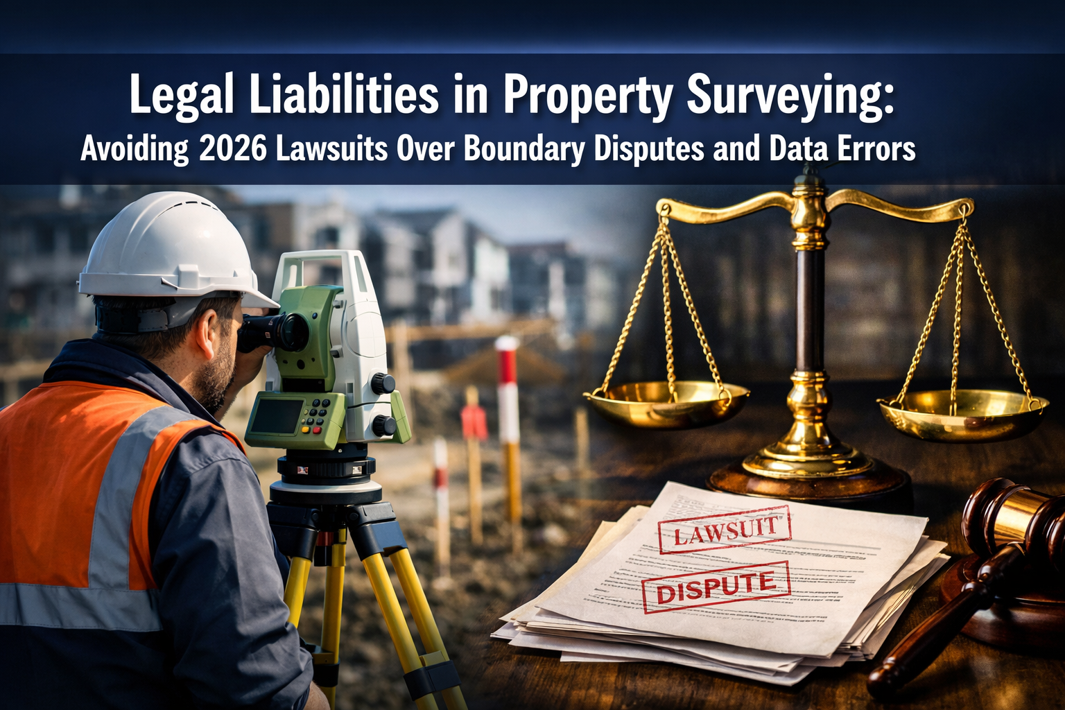
The stakes have never been higher for property surveyors. As residential and commercial developments grow more complex in 2026, a single overlooked boundary marker or misreported encroachment can trigger costly litigation that threatens both professional reputation and financial stability. Legal Liabilities in Property Surveying: Avoiding 2026 Lawsuits Over Boundary Disputes and Data Errors has become a critical concern for surveying professionals navigating an increasingly litigious landscape where clients, title insurers, and neighboring property owners scrutinize every measurement and notation.
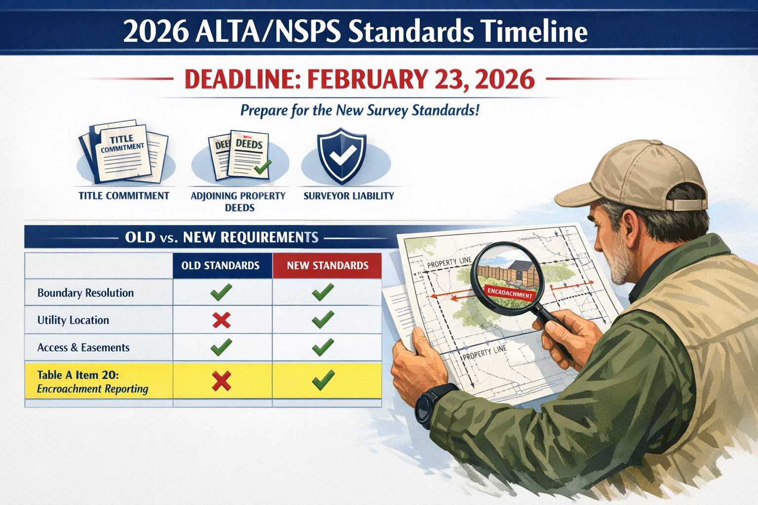
Recent changes to industry standards, particularly the 2026 ALTA/NSPS Land Title Survey Standards effective February 23, 2026, have fundamentally reshaped surveyor responsibilities and liability exposure. These updates introduce new documentation requirements, shift traditional responsibilities between parties, and create both opportunities and risks for surveying professionals. Understanding these changes—and implementing robust risk mitigation strategies—is no longer optional for surveyors who want to protect their practices from devastating lawsuits.
This comprehensive guide examines the evolving legal landscape facing property surveyors in 2026, explores common liability pitfalls through real-world case studies, and provides actionable strategies for minimizing legal exposure while maintaining professional excellence.
Key Takeaways
- ⚖️ New 2026 standards effective February 23 require standardized encroachment reporting (Table A Item 20), eliminating past ambiguities that frequently led to disputes over what was disclosed
- 📋 Surveyors now bear responsibility for obtaining adjoining property deeds, shifting liability exposure previously shared with title insurers
- 🔍 Undefined distance requirements for occupation lines create potential liability—courts have held surveyors liable for missing evidence 230 feet from property perimeters
- 🛡️ Professional standard of care remains the primary defense in litigation, requiring surveyors to demonstrate competence consistent with peers operating under similar circumstances
- 💼 Enhanced documentation and insurance serve as essential safeguards against the rising tide of boundary dispute and data error lawsuits
Understanding the 2026 Legal Landscape for Property Surveyors
The Evolution of ALTA/NSPS Standards and Surveyor Liability
The American Land Title Association (ALTA) and National Society of Professional Surveyors (NSPS) have jointly maintained land title survey standards for decades, but the 2026 revisions represent some of the most significant changes to surveyor responsibilities in recent memory. These standards don't merely suggest best practices—they establish the baseline against which professional competence and liability are measured in courtrooms across the country.
The February 23, 2026 effective date marks a clear dividing line in the surveying profession.[1] All surveys begun on or after this date must comply with the new requirements, creating potential transition challenges for projects straddling the deadline. Surveyors who fail to properly specify which standards govern their work may find themselves defending against claims that they should have applied whichever standard is more favorable to the plaintiff—a no-win situation.
The most visible change involves Table A Item 20, which creates a standardized format for documenting potential encroachments, overlaps, and protrusions.[1] Previously, surveyors used varying language or sometimes declined to opine on potential boundary conflicts, creating ambiguity that frequently spawned disputes. The new standardized reporting requirement aims to reduce these conflicts by establishing clear expectations for what surveyors must disclose.
Shifted Responsibilities: Who Bears the Burden?
One of the most controversial changes in the 2026 standards involves the elimination of the requirement that title insurers provide surveyors with copies of adjoining property deeds.[2][3] This responsibility now falls squarely on the surveyor's shoulders, fundamentally altering the risk landscape.
Critics argue this shift increases liability exposure for surveyors who may lack the resources or expertise to efficiently obtain and interpret adjoining property documentation. However, proponents note that many state survey standards already charge surveyors with determining adjoining property relationships, making this change merely a standardization of existing best practices.[3]
| Responsibility | Pre-2026 Standard | 2026 Standard | Liability Impact |
|---|---|---|---|
| Adjoining property deeds | Title insurer provides | Surveyor obtains | ⬆️ Increased surveyor liability |
| Encroachment reporting | Varied language/optional | Standardized Table A Item 20 | ⬇️ Reduced ambiguity disputes |
| Utility evidence scope | On property | On property + 5 feet (poles: 10 feet) | ⬆️ Expanded observation area |
| Title commitment access | Recommended | Mandatory prerequisite | ⬆️ Clear responsibility chain |
This table illustrates how the 2026 standards redistribute responsibilities in ways that both clarify expectations and expand surveyor obligations. For professionals working on boundary disputes in London and surrounding areas, understanding these shifts is essential for proper risk management.
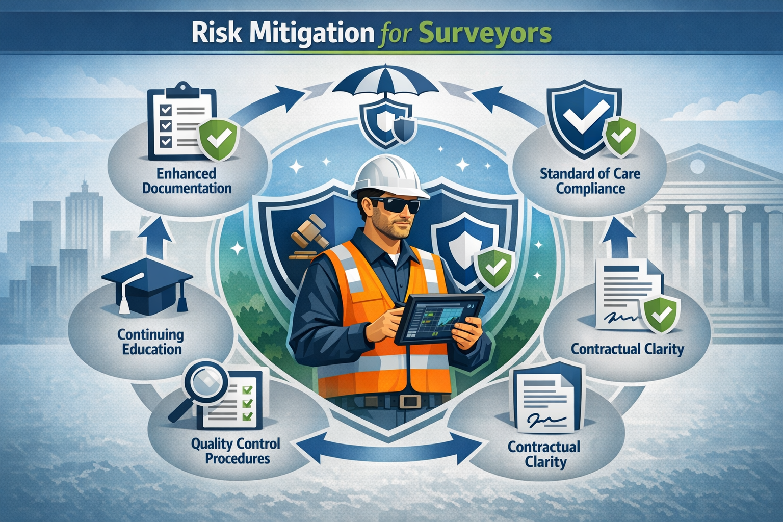
Contractual Clarity: Your First Line of Defense
The transition period surrounding the February 23, 2026 effective date creates particular vulnerability for surveyors. Contracts executed before this date but completed after may create ambiguities about which standard applies.[3] Smart surveyors are proactively addressing this issue by including explicit contractual clauses specifying which standard governs their work.
Consider this scenario: A surveyor signs a contract on February 15, 2026, under the assumption that pre-2026 standards apply, but doesn't complete fieldwork until March 1, 2026. If a dispute arises, the client might argue the new standards should apply since the work was performed after the effective date. Without clear contractual language, the surveyor faces uncertainty about their obligations and potential liability exposure.
Best practice recommendations include:
- ✅ Explicitly stating which ALTA/NSPS standard version applies in all survey agreements
- ✅ Defining the "commencement date" that triggers standard applicability
- ✅ Including provisions for standard changes during extended project timelines
- ✅ Obtaining client acknowledgment of the applicable standard in writing
- ✅ Maintaining documentation of when fieldwork actually began
These contractual safeguards provide critical protection when disputes arise, establishing clear expectations that can prevent or resolve conflicts before they escalate to litigation.
Common Liability Pitfalls in Legal Liabilities in Property Surveying: Avoiding 2026 Lawsuits Over Boundary Disputes and Data Errors
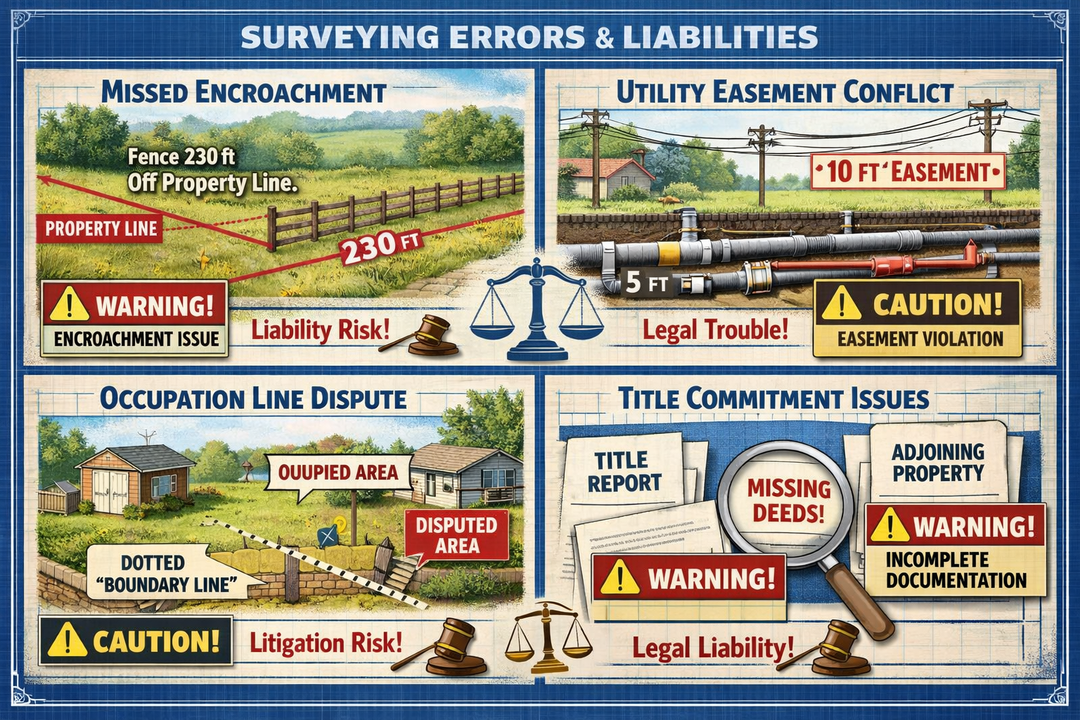
The 230-Foot Problem: Undefined Distance Requirements
Perhaps no aspect of the 2026 standards creates more uncertainty than the undefined distance requirement for documenting occupation and possession lines. While the standards require surveyors to identify evidence of occupation or possession, they don't specify how far from the property boundary surveyors must search for such evidence.
This ambiguity became painfully clear in a referenced court case where a surveyor was held liable for failing to document a line of occupation located 230 feet from the property perimeter.[3] This case sends a chilling message to surveyors: the absence of defined distance requirements doesn't limit liability—it expands it to whatever distance a court deems reasonable after the fact.
"The professional standard of care defense implies that liability determinations will rest on whether a competent surveyor, operating under similar circumstances in the same area, would have observed the disputed feature."[3]
This standard of care analysis creates geographic and contextual variability. What's reasonable in a dense urban environment may differ dramatically from expectations in rural areas. A surveyor working on projects in central London faces different occupation line challenges than one surveying expansive rural properties.
Practical implications for surveyors:
- 🔍 Visual inspection areas must extend well beyond immediate property boundaries
- 📸 Photographic documentation of extended survey areas provides critical evidence
- 📝 Field notes should explicitly document observation distances and methods
- 🗺️ Aerial imagery and drone surveys can help identify distant occupation evidence
- 👥 Consulting with local peers establishes regional standard of care benchmarks
For surveyors utilizing modern technology, drone roof surveys and aerial documentation can provide comprehensive visual records that demonstrate due diligence in searching for occupation evidence at considerable distances.
Utility Evidence: The Five-Foot (and Ten-Foot) Rule
The 2026 standards introduce refined requirements for documenting utility evidence, mandating that surveyors show utilities "on and within five feet of the surveyed property" with an extended ten-foot requirement for utility poles.[2] This seemingly minor change carries significant liability implications.
Why this matters:
Utilities located just outside property boundaries frequently create easement conflicts, encroachment issues, and access disputes. A utility line five feet beyond the property line might seem irrelevant until a client discovers it prevents desired construction or creates maintenance access obligations. When that client sues, the surveyor who failed to document the utility faces liability for the resulting damages.
Common utility-related liability scenarios include:
- Undocumented overhead power lines within ten feet that restrict building height or placement
- Underground utilities within five feet that conflict with planned excavation or foundation work
- Utility easements not properly identified or measured, leading to title insurance claims
- Access requirements for utility maintenance that restrict property use
- Shared utility infrastructure creating ongoing maintenance cost disputes
The expanded observation area means surveyors must now conduct more thorough utility investigations, potentially including:
- 📞 Contacting utility companies for as-built documentation
- 🔦 Using utility locating services for underground infrastructure
- 📋 Reviewing utility easement documents from title commitments
- 🎯 Physically marking and measuring utility features during fieldwork
- 📊 Creating detailed utility exhibits showing precise locations and relationships
Easement Identification: Appurtenant vs. In Gross
The 2026 standards bring clearer requirements for easement identification, particularly distinguishing between appurtenant easements (benefiting the surveyed property) and easements in gross (benefiting specific parties).[3] Section 6.C.viii specifically addresses how to handle easements not listed in the title commitment, recognizing that easements can be terminated through multiple methods beyond simple release.
This clarity helps surveyors avoid a common liability pitfall: failing to identify beneficial easements that the property owner needs for access, utilities, or other purposes. When a surveyor misses an appurtenant easement, the consequences can be severe:
- 🚫 Blocked access to the property
- 💰 Reduced property value due to landlocked status
- ⚖️ Title insurance claims and coverage disputes
- 🏗️ Inability to complete planned development
- 📉 Failed real estate transactions
Conversely, failing to identify easements burdening the property creates different but equally serious problems. A buyer who discovers after closing that their new property is subject to a neighbor's access easement across the backyard will likely seek damages from the surveyor who missed this critical encumbrance.
For professionals handling complex party wall matters and boundary disputes, understanding easement relationships is particularly critical, as these issues frequently intersect with shared property features and access rights.
Title Commitment Access: A Mandatory Prerequisite
The 2026 standards make explicit what was previously implied: surveyors must be provided with the most recent title commitment or title evidence satisfactory to the title insurer.[2][3] This isn't merely a helpful resource—it's a mandatory prerequisite for proper survey completion.
This requirement protects surveyors by establishing that they cannot be expected to complete a compliant survey without adequate title information. However, it also creates new liability exposure when surveyors proceed without proper title documentation or fail to adequately review the title commitment they receive.
Critical title commitment review elements:
| Title Element | Survey Implication | Liability Risk if Missed |
|---|---|---|
| Recorded easements | Must be located and shown | High – affects property use and value |
| Boundary descriptions | Must match survey findings | Critical – fundamental survey accuracy |
| Exceptions and exclusions | May require additional investigation | Medium – scope definition issues |
| Prior surveys | Comparison for consistency | Medium – unexplained discrepancies |
| Adjoining owner information | Required for deed research | High – boundary determination accuracy |
Surveyors who receive inadequate title information face a critical decision: proceed with the survey and accept increased liability risk, or refuse to proceed until proper documentation is provided. The 2026 standards support the latter approach, making it clear that adequate title evidence is a prerequisite, not an optional enhancement.
Risk Mitigation Strategies for Legal Liabilities in Property Surveying: Avoiding 2026 Lawsuits Over Boundary Disputes and Data Errors
Enhanced Documentation: Your Liability Shield
In surveying litigation, documentation is destiny. The surveyor who can produce comprehensive field notes, photographs, calculations, and research documentation stands a far better chance of successfully defending against claims than one who relies on memory or minimal records.
The 2026 standards' emphasis on standardized reporting creates an opportunity for surveyors to establish documentation protocols that not only ensure compliance but also create powerful liability defenses. Consider implementing these enhanced documentation practices:
Field Documentation Protocol:
- 📸 Photographic evidence: Take comprehensive photos of all property boundaries, occupation evidence, utilities, and potential encroachments, with GPS coordinates and timestamps
- 📝 Detailed field notes: Document observation methods, measurement techniques, weather conditions, and any factors affecting survey accuracy
- 🎥 Video documentation: For complex properties, video walkthroughs provide context that static photos cannot capture
- 🗺️ Sketch maps: Preliminary field sketches showing relationships between features help explain final survey decisions
- ⏱️ Time logs: Detailed records of time spent on various survey components demonstrate thoroughness
Research Documentation Protocol:
- 📄 Deed research records: Maintain copies of all deeds reviewed, with notes explaining interpretation and boundary determination
- 📋 Title commitment review: Document all title commitment items reviewed and how they were addressed in the survey
- 📞 Communication logs: Record all conversations with clients, title companies, adjoining owners, and other stakeholders
- 🔍 Record search documentation: Keep records of all courthouse, municipal, and utility company research conducted
- 📚 Reference materials: Document which standards, regulations, and reference materials guided survey decisions
For surveyors working across multiple jurisdictions, such as those serving chartered surveyors in Kingston and chartered surveyors in Richmond, maintaining consistent documentation protocols across all projects creates defensible patterns of professional practice.
Professional Liability Insurance: Non-Negotiable Protection
Professional liability insurance (errors and omissions insurance) is not optional for surveyors practicing in 2026's litigious environment. However, not all policies provide equal protection, and understanding coverage details can mean the difference between financial survival and bankruptcy when claims arise.
Key insurance considerations:
🛡️ Coverage limits: Ensure limits reflect the value of properties you survey and potential damages from errors. A $1 million policy may seem adequate until you're sued over a boundary error affecting a $5 million commercial development.
🛡️ Claims-made vs. occurrence policies: Understand whether your policy covers claims made during the policy period (claims-made) or incidents occurring during the policy period (occurrence). Claims-made policies require continuous coverage or "tail" coverage when you retire or change insurers.
🛡️ Prior acts coverage: Ensure coverage for surveys completed before your current policy period, as claims often arise years after survey completion.
🛡️ Defense cost coverage: Verify whether defense costs are included within policy limits or provided in addition to limits. Legal defense can easily exceed claim settlements.
🛡️ Exclusions and limitations: Carefully review exclusions for specific survey types, technologies, or circumstances that might leave you unprotected.
Policy enhancement strategies:
- 💼 Work with insurance brokers specializing in surveyor professional liability
- 📊 Provide detailed information about your practice areas, technologies, and quality control procedures to obtain appropriate coverage
- 🔄 Review and update coverage annually as your practice evolves
- 📋 Understand claim reporting requirements and report potential claims promptly
- 🎓 Participate in insurer-sponsored risk management training programs
Many insurers offer premium discounts for surveyors who implement robust quality control procedures, maintain professional certifications, and participate in continuing education—creating financial incentives for practices that also reduce liability risk.
Quality Control Procedures: Catching Errors Before Clients Do
Systematic quality control (QC) procedures represent one of the most effective liability reduction strategies available to surveying firms. By catching errors internally before delivering final products, surveyors avoid the far more costly process of defending against claims or correcting errors after clients have relied on flawed surveys.
Multi-level QC framework:
Level 1 – Self-Review:
- ✅ Field crew reviews measurements and observations before leaving the site
- ✅ Data processing technician verifies calculations and data integrity
- ✅ Surveyor reviews draft survey against field notes and source documents
- ✅ Automated checking software identifies mathematical inconsistencies
Level 2 – Peer Review:
- ✅ Another surveyor reviews the complete survey package
- ✅ Focus on compliance with applicable standards and client requirements
- ✅ Verification of boundary determinations and encroachment identifications
- ✅ Review of all Table A items and optional items requested
Level 3 – Senior Review:
- ✅ Principal or senior surveyor provides final review before delivery
- ✅ Emphasis on liability risk identification and mitigation
- ✅ Verification of professional judgment calls and opinions
- ✅ Final approval authority before client delivery
Common errors caught through QC:
| Error Type | Frequency | Potential Liability | QC Detection Method |
|---|---|---|---|
| Calculation errors | High | Medium | Automated checking software |
| Missed encroachments | Medium | High | Peer review, photo analysis |
| Incorrect easement identification | Medium | High | Title commitment cross-check |
| Utility documentation gaps | High | Medium | Checklist verification |
| Boundary determination errors | Low | Critical | Senior surveyor review |
Implementing comprehensive QC procedures requires time and resources, but the cost is minimal compared to defending against even a single lawsuit. Moreover, clients increasingly expect—and contractually require—documented QC processes, making these procedures both a liability shield and a competitive advantage.
Continuing Education and Professional Development
The surveying profession evolves continuously, with new technologies, standards, regulations, and court decisions reshaping best practices. Surveyors who fail to keep pace with these changes face increased liability risk as their knowledge and practices become outdated.
The 2026 ALTA/NSPS standards themselves illustrate this reality. Surveyors who haven't educated themselves about the new requirements face potential liability for non-compliance, while those who have invested in understanding the changes can confidently adapt their practices.
Essential continuing education areas for 2026:
📚 Updated standards and regulations: Stay current on ALTA/NSPS standards, state-specific requirements, and local ordinances affecting surveying practice.
📚 Technology competency: Master new surveying technologies, from GPS and robotic total stations to drone photogrammetry and 3D laser scanning. Technology incompetence is increasingly difficult to defend in court.
📚 Legal developments: Monitor court decisions affecting surveyor liability, particularly cases involving boundary disputes, encroachment claims, and professional standard of care determinations.
📚 Risk management: Participate in training focused specifically on liability reduction, contract negotiation, and claims prevention.
📚 Specialized practice areas: Develop expertise in niche areas like party wall surveys or complex commercial developments that command premium fees and require specialized knowledge.
Professional organizations, including state surveying societies and NSPS, offer continuing education programs specifically designed to help surveyors maintain competency and reduce liability exposure. Many states require continuing education for license renewal, but smart surveyors exceed minimum requirements, recognizing that education is both a professional obligation and a liability shield.
Standard of Care Compliance: Your Ultimate Defense
When surveying disputes reach litigation, the central question typically becomes: Did the surveyor meet the professional standard of care? This standard asks whether a competent surveyor, operating under similar circumstances in the same geographic area, would have performed the work in substantially the same manner.[3]
Understanding and consistently meeting this standard provides the strongest possible defense against liability claims. However, the standard's contextual nature creates both challenges and opportunities for surveyors.
Factors affecting standard of care determinations:
🎯 Geographic location: Standards in urban areas may differ from rural expectations. A surveyor working in chartered surveyors in Hertfordshire might face different expectations than one in central London.
🎯 Property complexity: More complex properties justify more extensive investigation and analysis.
🎯 Available information: The standard considers what information was reasonably available to the surveyor at the time of the survey.
🎯 Industry standards: Compliance with ALTA/NSPS standards and other recognized professional standards strongly supports standard of care defenses.
🎯 Technology availability: Courts increasingly expect surveyors to use modern technology appropriate to the survey type and complexity.
🎯 Client instructions: The scope of work agreed with the client affects what's reasonable, though surveyors cannot contract away fundamental professional obligations.
Building a standard of care defense:
- 📋 Document your methodology: Explain why you chose specific approaches and techniques
- 👥 Consult with peers: For unusual situations, consulting with other professionals demonstrates diligence
- 📚 Follow published standards: Strict compliance with ALTA/NSPS and state standards creates strong presumption of competence
- 🎓 Maintain credentials: Professional licenses, certifications, and continuing education demonstrate commitment to competency
- 📝 Retain expert witnesses: Identify experts who can testify about standard of care in your practice area if litigation arises
The standard of care defense recognizes that surveying involves professional judgment, not absolute certainty. Surveyors who can demonstrate that their judgments were reasonable, well-informed, and consistent with professional norms will typically prevail even when their conclusions are later questioned.
Case Studies: Learning from Real-World Surveying Disputes
Case Study 1: The Missed Occupation Line
Situation: A surveyor completed an ALTA/NSPS survey for a commercial property acquisition. The survey showed no encroachments or occupation issues. Six months after closing, the buyer discovered that a neighboring property owner had been using a 20-foot-wide strip along the rear property boundary for vehicle access for over 15 years, potentially creating an adverse possession or prescriptive easement claim.
The Claim: The buyer sued the surveyor for $500,000, claiming the missed occupation line reduced the property's value and created title complications that prevented planned development.
Surveyor's Defense: The surveyor argued that the occupation evidence was not visible during the survey because the neighboring owner had temporarily removed vehicles and equipment during the survey period. The surveyor produced photographs showing no visible occupation evidence at the time of the survey.
Outcome: The case settled for $150,000 after expert testimony suggested that a competent surveyor should have investigated beyond visual observation, potentially including interviews with neighboring property owners or review of historical aerial imagery showing the long-term vehicle access pattern.
Lessons Learned:
- ⚠️ Visual observation alone may be insufficient for occupation line determination
- ⚠️ Historical research, including aerial imagery review, can reveal occupation patterns not visible during site visits
- ⚠️ Interviewing neighboring property owners, while not always practical, can uncover critical information
- ⚠️ Documenting the specific date and conditions of site visits provides important context if occupation evidence varies over time
Case Study 2: The Utility Easement Conflict
Situation: A surveyor completed a residential boundary survey showing the property free of encumbrances except for recorded easements listed in the title commitment. The survey showed utilities on the property but did not identify or measure utility lines located seven feet beyond the property boundary. After purchasing the property, the buyer discovered these nearby utilities prevented planned garage construction due to setback requirements from utility easements.
The Claim: The buyer sued for $75,000, representing the cost difference between the planned attached garage and a more expensive detached garage design required by the utility easement restrictions.
Surveyor's Defense: The surveyor argued that the pre-2026 standards in effect when the survey was completed did not require showing utilities beyond the property boundary. The surveyor also noted that the title commitment listed the utility easement, making the buyer aware of its existence.
Outcome: The surveyor prevailed at trial. The court found that the surveyor met the applicable standard of care under the pre-2026 standards and that the buyer had constructive notice of the easement through the title commitment, even though the survey did not show the precise utility locations.
Lessons Learned:
- ✅ Compliance with applicable standards at the time of survey provides strong defense
- ✅ Clear contractual specification of which standards apply protects against retroactive application of new requirements
- ✅ The 2026 standards' expanded utility documentation requirements would likely change this outcome for future surveys
- ✅ Surveyors should consider exceeding minimum standards when additional documentation provides significant value to clients
Case Study 3: The Encroachment Reporting Ambiguity
Situation: A surveyor completed a pre-2026 survey using language stating "possible encroachment of fence approximately 0.3 feet onto subject property." The buyer proceeded with the purchase, assuming the encroachment was minor and easily resolved. Post-closing investigation revealed the fence encroachment was actually 3.0 feet (not 0.3 feet) and included a concrete patio and landscaping, requiring expensive removal or a boundary line adjustment.
The Claim: The buyer sued for $100,000, claiming the surveyor's error in measuring and reporting the encroachment extent caused significant financial harm and created neighborhood conflict.
Surveyor's Defense: The surveyor claimed the "0.3 feet" notation was a typographical error and that the survey drawing clearly showed the fence location. The surveyor also argued that the survey included a disclaimer that measurements were approximate and subject to verification.
Outcome: The case settled for $65,000 after the surveyor's professional liability insurer determined that defending the typographical error claim would be difficult, particularly given the significant difference between 0.3 and 3.0 feet.
Lessons Learned:
- 🔴 Typographical errors in critical measurements can create substantial liability
- 🔴 The 2026 standardized encroachment reporting (Table A Item 20) is designed to prevent exactly this type of ambiguity
- 🔴 Quality control procedures must specifically verify that text descriptions match drawing depictions
- 🔴 Survey disclaimers provide limited protection when fundamental measurement errors occur
These case studies illustrate common liability scenarios and the critical importance of thorough investigation, accurate reporting, and compliance with applicable standards. For surveyors handling structural surveys and other complex property assessments, these lessons apply across all practice areas.
Navigating Contractual Protections and Limitations
Scope of Work Definitions
Clear scope of work definitions serve as the foundation for managing client expectations and limiting liability exposure. Ambiguous scope definitions create disputes about what the surveyor was obligated to provide, often resulting in claims that the surveyor failed to deliver expected services.
Essential scope of work elements:
📄 Survey type and applicable standards: Explicitly state whether the survey will comply with ALTA/NSPS standards, state-specific standards, or other requirements.
📄 Property description: Clearly identify the property to be surveyed, including legal description and any limitations on survey extent.
📄 Deliverables: Specify exactly what the client will receive (survey drawing, legal description, digital files, etc.) and in what format.
📄 Optional items: For ALTA/NSPS surveys, clearly identify which Table A optional items are included or excluded.
📄 Limitations and exclusions: Explicitly state what the survey will not include (subsurface features, interior improvements, etc.).
📄 Reliance parties: Identify who may rely on the survey (client, lender, title company, etc.) and any limitations on third-party reliance.
Dangerous scope ambiguities to avoid:
- ❌ "Complete boundary survey" (without specifying standards or deliverables)
- ❌ "Locate all utilities" (without defining observation methods or extent)
- ❌ "Identify all encroachments" (without specifying observation limitations)
- ❌ "Show all easements" (without clarifying whether this includes unrecorded easements)
For professionals providing valuation reports alongside surveying services, clearly distinguishing between survey and valuation scope prevents confusion about which professional standards apply to each service component.
Limitation of Liability Clauses
Limitation of liability clauses attempt to cap the surveyor's financial exposure in the event of errors or omissions. However, these clauses face significant enforceability challenges and should never be viewed as a substitute for competent professional practice.
Common limitation approaches:
💼 Fee-based limitations: Limiting liability to a multiple of the survey fee (e.g., "Surveyor's liability shall not exceed three times the fee paid for this survey").
💼 Fixed dollar caps: Setting a specific maximum liability amount regardless of actual damages.
💼 Consequential damages exclusions: Attempting to exclude liability for indirect or consequential damages while accepting responsibility for direct damages.
💼 Time limitations: Requiring claims to be brought within a specified period after survey completion.
Enforceability challenges:
Courts often scrutinize limitation of liability clauses, particularly when:
- ⚖️ The limitation is grossly disproportionate to potential damages
- ⚖️ The clause attempts to limit liability for gross negligence or intentional misconduct
- ⚖️ The client lacked meaningful opportunity to negotiate the limitation
- ⚖️ The limitation violates public policy or professional regulations
- ⚖️ The clause is buried in fine print or not clearly disclosed
Best practices for limitation clauses:
- ✅ Make limitations conspicuous and clearly disclosed in contracts
- ✅ Ensure limitations are reasonable relative to the survey complexity and property value
- ✅ Consider offering clients the option to pay higher fees for surveys without limitations
- ✅ Consult with legal counsel to ensure limitations comply with state law
- ✅ Never rely on limitations as a substitute for quality work and adequate insurance
Even when enforceable, limitation of liability clauses may not prevent lawsuits—they simply limit potential damages. The reputational harm, defense costs, and professional stress of litigation remain significant even when liability is ultimately limited.
Third-Party Reliance Provisions
Third-party reliance provisions address who may legally rely on the survey beyond the original client. This issue frequently arises when properties are resold, refinanced, or when lenders and title companies use surveys for their underwriting decisions.
Typical reliance scenarios:
🏢 Lender reliance: Commercial lenders typically require the right to rely on surveys as a condition of financing.
🏢 Title company reliance: Title insurers rely on surveys to identify exceptions and exclusions from coverage.
🏢 Subsequent purchaser reliance: New buyers may want to rely on existing surveys rather than commissioning new ones.
🏢 Tenant reliance: Commercial tenants may rely on surveys when evaluating lease premises.
Liability implications:
Each party granted reliance rights becomes a potential plaintiff in the event of survey errors. Expanding reliance beyond the original client increases liability exposure, justifying higher fees or additional insurance coverage.
Managing third-party reliance:
- 📋 Explicitly list all parties authorized to rely on the survey
- 📋 Require additional fees for expanded reliance rights
- 📋 Obtain updated title commitments when surveys are updated for new reliance parties
- 📋 Include time limitations on third-party reliance (e.g., "reliance expires 12 months after survey date")
- 📋 Prohibit assignment of reliance rights without surveyor consent
Some surveyors include "no third-party reliance" clauses in their standard agreements, then negotiate reliance rights and additional fees when clients request them. This approach ensures surveyors are compensated for the additional liability exposure created by expanded reliance.
Technology and Innovation in Reducing Survey Liability
GPS and Robotic Total Stations: Precision and Documentation
Modern surveying technology provides both enhanced accuracy and superior documentation capabilities that reduce liability risk. GPS systems and robotic total stations enable precision measurements while automatically recording data that can later prove the surveyor's diligence and methodology.
Liability reduction benefits:
- 📡 Accuracy: Modern GPS achieves centimeter-level accuracy, reducing measurement errors
- 💾 Automatic data recording: Electronic data files document exactly what was measured and when
- 🔄 Repeatability: Measurements can be independently verified using recorded coordinates
- 📊 Quality indicators: Real-time quality metrics help surveyors identify and correct errors during fieldwork
- 🗄️ Long-term data retention: Electronic records can be preserved indefinitely for future reference
However, technology also creates new liability risks. Surveyors must understand equipment limitations, calibration requirements, and appropriate applications. Using GPS in heavily wooded areas where satellite reception is poor, for example, may produce inaccurate results that create liability exposure.
Drone Photogrammetry and Aerial Imaging
Drone technology has revolutionized property surveying by enabling comprehensive aerial documentation at reasonable costs. For surveyors concerned about the "230-foot problem" of undefined occupation line distances, drones provide a practical solution for documenting extensive areas around surveyed properties.
Applications for liability reduction:
- 🚁 Comprehensive visual documentation: Aerial photos show property context and potential occupation evidence
- 🗺️ Topographic mapping: Photogrammetry creates detailed terrain models without extensive ground surveys
- 📸 Roof and building documentation: Drones safely document features that are difficult or dangerous to access
- 🔍 Historical comparison: Periodic drone surveys create visual records showing property changes over time
- 🎥 Video documentation: Aerial video provides context that static photos cannot capture
Professional surveyors offering drone roof surveys in London have found that clients value the comprehensive documentation these services provide, while surveyors benefit from the liability protection of thorough visual records.
Regulatory compliance considerations:
Drone operations require compliance with aviation regulations, including pilot licensing, airspace restrictions, and privacy considerations. Surveyors must ensure their drone operations comply with all applicable regulations to avoid additional liability exposure.
3D Laser Scanning and Building Information Modeling
3D laser scanning technology creates detailed point cloud models of properties, capturing millions of measurements in minutes. This technology is particularly valuable for complex commercial properties, historic structures, and properties where comprehensive as-built documentation is critical.
Liability advantages:
- 🎯 Comprehensive measurement: Captures far more detail than traditional surveying methods
- 🏗️ Building information modeling (BIM) integration: Creates digital models that clients can use for planning and design
- 📐 Dimensional verification: Provides definitive records of existing conditions
- 🔄 Future reference: Point cloud data can be revisited years later to answer questions about property conditions
- ✅ Quality assurance: Comprehensive data capture reduces the risk of missing critical features
The upfront cost of 3D laser scanning equipment is substantial, but the technology's ability to capture comprehensive data in single site visits often justifies the investment for firms handling complex commercial projects.
Survey Management Software and Quality Control Systems
Specialized survey management software helps firms implement systematic quality control procedures, manage project workflows, and maintain comprehensive documentation—all critical for liability reduction.
Key software capabilities:
- ✅ Automated checking: Software identifies mathematical inconsistencies and potential errors
- 📋 Checklist management: Ensures all required survey elements are completed before delivery
- 🗂️ Document management: Organizes field notes, photos, research documents, and final deliverables
- 👥 Workflow tracking: Manages multi-step review processes and approval requirements
- 📊 Reporting: Generates standardized reports that ensure consistency across projects
Implementing survey management software requires training and process changes, but the liability reduction benefits—particularly the ability to demonstrate systematic quality control—justify the investment for firms serious about risk management.
Conclusion: Building a Liability-Resistant Surveying Practice in 2026
Legal Liabilities in Property Surveying: Avoiding 2026 Lawsuits Over Boundary Disputes and Data Errors requires a comprehensive, proactive approach that addresses every aspect of professional practice. The 2026 ALTA/NSPS standards have fundamentally reshaped surveyor responsibilities, creating both new requirements and new liability exposures that demand immediate attention.
The surveyors who will thrive in this evolving landscape are those who recognize that liability reduction is not about avoiding responsibility—it's about embracing professional excellence. By implementing enhanced documentation protocols, maintaining robust quality control procedures, investing in appropriate technology, and ensuring adequate professional liability insurance, surveyors can protect their practices while delivering superior service to clients.
Actionable Next Steps
Immediate actions (complete within 30 days):
- ✅ Review all survey contracts to ensure they specify which ALTA/NSPS standards apply and include clear scope of work definitions
- ✅ Verify professional liability insurance coverage limits, exclusions, and claims reporting requirements
- ✅ Educate all staff about the 2026 ALTA/NSPS changes and their implications for daily practice
- ✅ Update survey templates to include Table A Item 20 standardized encroachment reporting
- ✅ Establish title commitment review protocols ensuring all surveys have proper title documentation before fieldwork begins
Short-term actions (complete within 90 days):
- 📋 Implement formal quality control procedures with documented review checklists and approval requirements
- 📚 Complete continuing education focused on the 2026 standards, liability reduction, and emerging technologies
- 🔍 Audit recent surveys for compliance with new standards and identify any potential liability exposures requiring client notification
- 💼 Consult with insurance broker about coverage adequacy and potential enhancements
- 🤝 Establish peer review relationships with other surveyors for consultation on complex or unusual situations
Long-term strategic actions (complete within one year):
- 🚁 Evaluate technology investments in drones, 3D laser scanning, or other tools that enhance accuracy and documentation
- 📊 Implement survey management software to systematize quality control and documentation
- 🎓 Develop specialized expertise in high-value practice areas that justify premium fees
- 📈 Create formal risk management program with regular training, policy updates, and performance monitoring
- 👥 Build relationships with legal counsel who can provide guidance on contracts, claims, and liability issues
The surveying profession in 2026 demands more than technical competence—it requires business acumen, risk awareness, and a commitment to continuous improvement. Surveyors who embrace these challenges will find that the same practices that reduce liability also enhance professional reputation, client satisfaction, and long-term business success.
For surveyors seeking professional guidance on complex boundary disputes, party wall matters, or specialized surveying services, partnering with experienced professionals who understand both the technical and legal dimensions of property surveying is essential. Whether you're working on projects requiring expert surveyor advice or navigating the complexities of party wall disputes, the investment in professional expertise pays dividends in both liability protection and client outcomes.
The legal landscape for property surveying will continue to evolve, but the fundamental principles remain constant: thorough investigation, accurate reporting, clear communication, and unwavering professional integrity. Surveyors who consistently apply these principles, supported by appropriate technology, insurance, and quality control systems, will successfully navigate the challenges of 2026 and beyond while building practices that serve clients, protect the public, and honor the surveying profession's highest standards.
References
[1] Key Takeaways From The 2026 Alta Nsps 1518118 – https://www.jdsupra.com/legalnews/key-takeaways-from-the-2026-alta-nsps-1518118/
[2] Five Key Updates 2026 Altansps Land Title Survey Standards – https://westwoodps.com/recent-blog-posts/five-key-updates-2026-altansps-land-title-survey-standards
[3] The 2026 Minimum Standard Detail Requirements For Alta Nsps Land Title Surveys – https://amerisurv.com/2026/02/01/the-2026-minimum-standard-detail-requirements-for-alta-nsps-land-title-surveys/