The surveying profession stands at a technological crossroads in 2026. While traditional methods have served the industry well for centuries, machine learning algorithms are now revolutionizing how surveyors collect, process, and interpret data. Imagine processing massive datasets in minutes rather than days, automatically identifying structural risks before they become catastrophic, and predicting natural hazards like flooding and landslides with unprecedented accuracy. This is not science fiction—it's the reality of Machine Learning Algorithms in Surveying: Automating Data Analysis and Predictive Risk Detection.
These intelligent systems can analyze thousands of data points simultaneously, detecting subtle patterns that human eyes might miss. By automating routine analysis tasks, machine learning frees surveyors to focus on complex problem-solving and client consultation, fundamentally transforming the profession's value proposition. As organizations transition toward enterprise-level AI implementation, understanding these technologies becomes essential for remaining competitive in an increasingly data-driven industry.
Key Takeaways
- 🤖 Machine learning algorithms process massive surveying datasets rapidly, identifying patterns and detecting structural changes that would take humans days or weeks to analyze manually
- 🌊 Predictive risk detection uses historical data to forecast natural hazards including flooding, landslides, and structural failures, though these applications remain in promising early development stages
- ⚡ Real-time data processing integration enables surveyors to receive instant, highly accurate analysis rather than waiting for post-processing, dramatically improving decision-making speed
- 📊 Automated analysis significantly increases efficiency, reducing data processing time by up to 70% while improving accuracy and consistency across projects
- 🚁 Technology integration combines ML with LiDAR, drones, and 3D scanning, creating comprehensive digital workflows that transform traditional surveying practices
Understanding Machine Learning Fundamentals in Surveying Applications
Machine learning represents a subset of artificial intelligence that enables computer systems to learn from data without explicit programming. In surveying contexts, these algorithms analyze patterns within spatial data, measurements, and environmental conditions to make predictions and automate decision-making processes.
What Makes Machine Learning Different from Traditional Analysis?
Traditional surveying data analysis requires human experts to manually review measurements, compare them against standards, and identify anomalies. This process is time-consuming and subject to human error, particularly when dealing with large datasets. Machine learning algorithms, by contrast, can:
- Process thousands of data points simultaneously without fatigue or attention lapses
- Identify subtle correlations between variables that humans might overlook
- Improve accuracy over time as they encounter more examples and scenarios
- Maintain consistency across projects and teams
- Scale effortlessly from small residential surveys to massive infrastructure projects
Core Machine Learning Techniques Used in Surveying
Several specific ML approaches have proven particularly valuable for surveying applications:
Supervised Learning algorithms learn from labeled training data to make predictions on new, unseen data. For example, a supervised learning model might be trained on thousands of structural surveys to automatically identify common defects like subsidence, dampness, or structural cracks in new property assessments.
Unsupervised Learning discovers hidden patterns in data without pre-labeled examples. These algorithms excel at clustering similar properties, identifying unusual measurement patterns, or detecting anomalies in terrain data that might indicate geological instability.
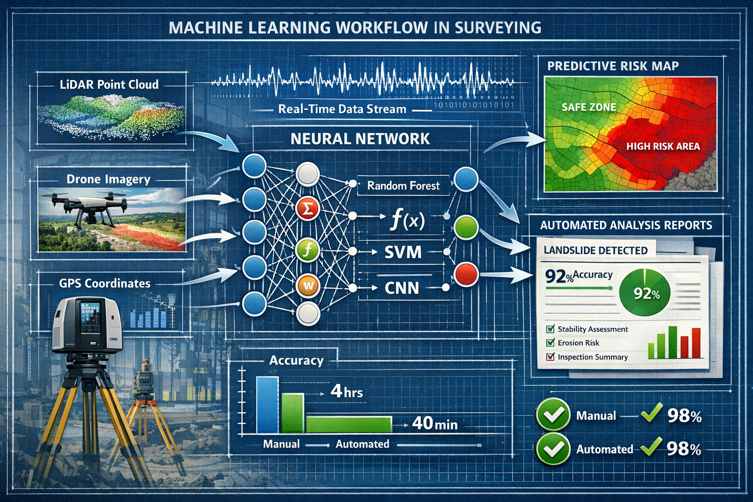
Deep Learning Neural Networks process complex, multi-dimensional data like LiDAR point clouds or aerial imagery. These sophisticated models can automatically extract features from raw sensor data, eliminating manual preprocessing steps.
Ensemble Methods combine multiple algorithms to improve prediction accuracy and reliability—critical when survey results inform high-stakes construction or property purchase decisions.
Machine Learning Algorithms in Surveying: Automating Data Analysis Workflows
The automation capabilities of machine learning algorithms fundamentally transform how surveying firms operate. According to industry analysis, AI significantly increases efficiency by reducing the time required to analyze gathered survey data[1]. This efficiency gain extends far beyond simple time savings—it enables entirely new service offerings and business models.
Automated Point Cloud Processing
LiDAR scanning and photogrammetry generate millions of three-dimensional data points representing physical spaces. Traditionally, surveyors spent hours manually cleaning these point clouds, removing noise, and extracting meaningful measurements. Machine learning algorithms now automate these tasks:
| Traditional Method | ML-Automated Method | Time Savings |
|---|---|---|
| Manual point classification | Automated semantic segmentation | 60-80% reduction |
| Visual defect identification | AI-powered anomaly detection | 70-85% reduction |
| Measurement extraction | Automated feature recognition | 50-70% reduction |
| Report generation | Template-based auto-reporting | 40-60% reduction |
Advanced surveying technology now incorporates real-time data processing powered by AI, enabling surveyors to receive instant, highly accurate survey data rather than post-processing analysis[1]. This capability proves particularly valuable during drone roof surveys, where immediate feedback allows operators to identify coverage gaps or data quality issues while still on-site.
Change Detection and Monitoring Applications
Machine learning excels at monitoring terrain and structural changes over time for environmental studies and construction monitoring applications[1]. These algorithms compare sequential datasets to automatically identify:
- Structural movement indicating potential foundation issues or settlement
- Vegetation growth patterns affecting property boundaries or sightlines
- Erosion or land degradation that might increase flood or landslide risk
- Construction progress verification against approved plans and timelines
- Unauthorized alterations to protected or regulated structures
For organizations conducting regular roof surveys, automated change detection identifies deterioration patterns early, enabling proactive maintenance recommendations that prevent costly emergency repairs.
Automated Quality Assurance and Error Detection
Human error represents a persistent challenge in surveying work. Machine learning algorithms provide continuous quality assurance by:
- Validating measurement consistency across different instruments and operators
- Identifying outlier readings that might indicate equipment malfunction or environmental interference
- Checking dimensional relationships to ensure physical impossibilities aren't recorded
- Comparing against historical norms for similar property types or locations
- Flagging incomplete data collection before leaving the survey site
This automated quality control reduces the risk of expensive resurveys and protects professional liability by catching errors before they reach clients or regulatory authorities.
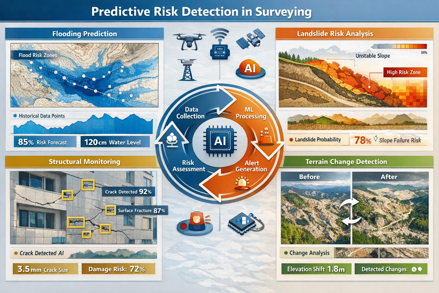
Predictive Risk Detection Through Machine Learning in Property Surveys
Perhaps the most transformative application of Machine Learning Algorithms in Surveying: Automating Data Analysis and Predictive Risk Detection involves forecasting future problems before they manifest. AI and machine learning are being deployed in property surveys to predict natural hazards including flooding and landslides using historical data[4]. While these predictive tools remain in early development stages, they are considered "very promising" by industry professionals[1].
Flood Risk Prediction Models
Flooding represents one of the most significant risks to property values and safety. Traditional flood risk assessment relies on historical flood maps and elevation data. Machine learning enhances these approaches by:
- Integrating multiple data sources including rainfall patterns, soil permeability, drainage infrastructure capacity, and climate change projections
- Identifying micro-topographic features that create localized flood risks not visible on standard flood maps
- Predicting future risk evolution based on development patterns and environmental changes
- Generating property-specific risk scores rather than broad zone classifications
These granular predictions enable surveyors to provide clients with actionable intelligence about flood protection investments, insurance considerations, and long-term property value implications.
Landslide and Slope Stability Analysis
Machine learning algorithms analyze geological data, slope angles, soil composition, vegetation cover, and historical movement patterns to assess landslide risk. Key capabilities include:
Early Warning Detection: Algorithms process sensor data from ground-based monitoring systems to identify subtle movement patterns indicating impending slope failure, often weeks or months before visible signs appear.
Risk Mapping: ML models create detailed risk maps showing probability gradients across large areas, helping surveyors prioritize investigation resources and advise clients on site selection.
Triggering Factor Analysis: By correlating historical landslide events with weather patterns, seismic activity, and human interventions, algorithms identify specific conditions that elevate risk levels.
Structural Failure Prediction
For structural surveys, machine learning algorithms analyze building characteristics, material properties, construction methods, maintenance history, and environmental exposure to predict:
- Remaining useful life of critical structural elements
- Probability of specific failure modes (foundation settlement, roof collapse, wall cracking)
- Maintenance intervention timing to maximize cost-effectiveness
- Renovation impact assessment on structural integrity
"The surveying industry is moving toward fully integrated digital workflows using AI, cloud platforms, autonomous drones, and real-time 3D modeling, with increasing automation reducing manual work." [1]
This predictive capability transforms surveyors from reactive problem identifiers into proactive risk managers, adding substantial value to client relationships.
Subsidence and Settlement Monitoring
Subsidence—the gradual sinking or settling of ground—damages thousands of properties annually. Machine learning enhances detection and prediction through:
- Satellite radar interferometry analysis processing years of satellite data to detect millimeter-scale ground movement
- Correlation with causative factors including groundwater extraction, mining activities, clay soil shrinkage, and tree root impacts
- Progression rate prediction helping property owners and insurers understand timeline and severity
- Intervention effectiveness modeling evaluating potential remediation strategies
These capabilities prove particularly valuable for chartered surveyors advising on property purchases in areas with known subsidence history.
Technology Stack: Integrating ML with Modern Surveying Equipment
The power of Machine Learning Algorithms in Surveying: Automating Data Analysis and Predictive Risk Detection emerges from integration with complementary technologies. Current ML implementations utilize LiDAR mapping, 3D laser scanning, GNSS RTK systems (real-time kinematics), UAV photogrammetry, and mobile mapping systems alongside AI-powered data processing[1].
LiDAR and 3D Laser Scanning Integration
Light Detection and Ranging (LiDAR) technology uses laser pulses to create precise three-dimensional representations of physical spaces. When combined with machine learning:
- Automated object classification distinguishes between buildings, vegetation, vehicles, and infrastructure without manual tagging
- Feature extraction algorithms automatically identify architectural elements, utilities, and site features
- Defect detection systems highlight cracks, deformation, or damage in structures
- Volumetric calculations for earthwork, material quantities, or storage capacity happen instantly
The combination of high-resolution spatial data with intelligent analysis algorithms enables surveyors to deliver insights that would be impossible through traditional methods.
GNSS RTK and Positioning Accuracy
Global Navigation Satellite System Real-Time Kinematic (GNSS RTK) positioning achieves centimeter-level accuracy by correcting satellite positioning errors. Machine learning enhances these systems by:
- Predicting signal interference patterns in urban canyons or forested areas
- Optimizing measurement timing based on satellite constellation geometry
- Detecting multipath errors where signals reflect off buildings or terrain
- Fusing multiple positioning sources (GPS, GLONASS, Galileo, BeiDou) for maximum reliability
This positioning precision forms the foundation for accurate spatial analysis and risk modeling.
Drone Technology and Aerial Data Collection
Drone usage has expanded significantly due to decreased costs and improved accessibility, particularly when combined with real-time kinematics (RTK) and post-processing kinematic (PPK) positioning that enhance accuracy through satellite-based systems[1]. Machine learning transforms drone surveying through:
Autonomous Flight Planning: Algorithms optimize flight paths for complete coverage while minimizing battery consumption and flight time, automatically adjusting for wind conditions and obstacle avoidance.
Real-Time Image Analysis: On-board processing identifies data quality issues, coverage gaps, or areas requiring additional detail while the drone is still airborne, eliminating costly return visits.
Automated Feature Detection: ML models trained on thousands of aerial images automatically identify roof damage, vegetation encroachment, drainage issues, or unauthorized structures.
3D Model Generation: Photogrammetry algorithms process hundreds of overlapping images to create accurate three-dimensional models without manual intervention.
Mobile Mapping Systems
Mobile mapping combines vehicle-mounted cameras, LiDAR scanners, and positioning systems to rapidly survey roads, utilities, and infrastructure. Machine learning enables:
- Automated asset inventory cataloging signs, poles, manholes, and infrastructure elements
- Pavement condition assessment identifying cracks, potholes, and surface deterioration
- Clearance analysis for utility lines and transportation routes
- Change detection comparing sequential surveys to identify unauthorized modifications or deterioration
These systems dramatically reduce the time and cost of large-scale infrastructure surveys while improving data completeness and consistency.
Enterprise Implementation: Building AI Capabilities in Surveying Organizations
While specific adoption statistics are limited in recent sources, industry analysis indicates 2026 represents a transition year toward enterprise-level implementation of AI technologies rather than individual-based deployments[3]. Organizations implementing ML-driven surveying are developing "AI factories"—combinations of technology platforms, methods, data, and algorithms that accelerate surveying system development[3].
Infrastructure Requirements for ML-Powered Surveying
Successful implementation requires careful attention to foundational infrastructure:
Data Management Systems: Machine learning algorithms require large volumes of high-quality training data. Organizations must establish:
- Centralized data repositories storing historical survey data in standardized formats
- Data annotation workflows for labeling training examples
- Version control systems tracking algorithm improvements and model updates
- Quality assurance processes ensuring data accuracy and completeness
Computing Resources: Processing large spatial datasets demands significant computational power:
- Cloud computing platforms providing scalable processing capacity
- GPU acceleration for deep learning model training
- Edge computing devices enabling real-time analysis in field conditions
- Hybrid architectures balancing cost, performance, and data security
Software Ecosystem: Organizations require integrated software platforms supporting:
- Data ingestion from diverse surveying instruments and formats
- Algorithm development and training environments
- Model deployment and monitoring infrastructure
- Visualization and reporting tools for client deliverables
Workforce Development and Training
Technology alone cannot deliver value—organizations must develop human capabilities alongside technical infrastructure:
Upskilling Existing Surveyors: Traditional surveyors need training in:
- Data science fundamentals to understand algorithm capabilities and limitations
- Quality assessment for ML-generated outputs
- Client communication explaining AI-enhanced insights
- Technology operation for new surveying equipment
Recruiting Hybrid Talent: The industry increasingly seeks professionals with combined expertise in surveying principles and data science, creating new career pathways.
Collaborative Workflows: Successful organizations establish teams combining domain expertise (surveying knowledge) with technical expertise (machine learning development), fostering collaboration rather than siloed specialization.
Ethical Considerations and Professional Standards
As automation increases, professional bodies and practitioners must address important ethical questions:
Professional Responsibility: When algorithms make recommendations, who bears responsibility for errors—the surveyor, the software developer, or the organization? Clear frameworks for human oversight and professional judgment remain essential.
Bias and Fairness: ML algorithms trained on historical data may perpetuate past biases. For example, if training data overrepresents certain property types or geographic areas, predictions for underrepresented categories may be less accurate.
Transparency and Explainability: Clients and regulators increasingly demand understanding of how AI systems reach conclusions. "Black box" algorithms that cannot explain their reasoning face growing skepticism, particularly for high-stakes decisions.
Data Privacy and Security: Surveying data often includes sensitive information about property ownership, security vulnerabilities, and financial valuations. Organizations must implement robust data protection measures.
Professional organizations are developing updated standards and guidance addressing these considerations, ensuring that technological advancement aligns with professional ethics and public protection.
Real-World Applications and Case Studies
The theoretical benefits of Machine Learning Algorithms in Surveying: Automating Data Analysis and Predictive Risk Detection translate into tangible improvements across diverse applications:
Infrastructure Monitoring and Maintenance
Transportation agencies deploy ML-powered surveying systems to monitor bridges, roads, and railways. Algorithms analyze regular inspections to:
- Predict maintenance needs before failures occur, optimizing budget allocation
- Prioritize intervention locations based on deterioration rates and usage patterns
- Assess structural load capacity considering aging and environmental factors
- Optimize inspection schedules focusing resources on highest-risk assets
These applications reduce emergency repairs, extend infrastructure lifespan, and improve public safety.
Environmental and Natural Resource Management
Environmental agencies and conservation organizations use ML-enhanced surveying for:
Habitat Mapping: Automated classification of vegetation types, wetlands, and wildlife corridors from aerial imagery and LiDAR data, supporting conservation planning and regulatory compliance.
Erosion Monitoring: Change detection algorithms identify shoreline retreat, riverbank erosion, or hillslope degradation, enabling proactive intervention before significant damage occurs.
Forest Inventory: Automated tree counting, species identification, and health assessment from drone imagery and LiDAR, replacing labor-intensive manual surveys.
Mining Rehabilitation: Monitoring of reclamation progress at former mining sites, verifying compliance with environmental restoration requirements.
Urban Planning and Development
Municipal governments leverage ML-powered surveying for:
- 3D city modeling automatically generating detailed digital twins from aerial surveys
- Building compliance verification comparing as-built structures against approved plans
- Infrastructure capacity planning analyzing development patterns to predict utility demand
- Flood modeling incorporating detailed topography and drainage infrastructure
These applications support evidence-based planning decisions and regulatory enforcement.
Property Assessment and Valuation
For property professionals including chartered surveyors, machine learning enhances:
Automated Measurement Extraction: Algorithms calculate floor areas, room dimensions, and site boundaries from plans or 3D scans, reducing measurement disputes and improving consistency.
Comparative Market Analysis: ML models analyze thousands of comparable sales, adjusting for property characteristics, location factors, and market trends to generate accurate valuations.
Condition Assessment: Image recognition algorithms identify maintenance issues, building defects, and renovation opportunities from inspection photographs.
Investment Risk Modeling: Predictive algorithms assess rental income stability, capital appreciation potential, and ownership cost risks.
Challenges and Limitations of Current ML Surveying Applications

Despite impressive capabilities, Machine Learning Algorithms in Surveying: Automating Data Analysis and Predictive Risk Detection face important limitations that practitioners must understand:
Data Quality and Availability Constraints
Machine learning algorithms are only as good as their training data. Challenges include:
Historical Data Gaps: Many organizations lack comprehensive historical survey records in digital formats, limiting algorithm training. Legacy data exists only in paper archives or obsolete file formats.
Data Standardization Issues: Inconsistent measurement methods, varying equipment specifications, and changing professional standards create heterogeneous datasets that algorithms struggle to process uniformly.
Geographic Bias: Training data often concentrates in urban areas or developed regions, reducing algorithm accuracy for rural or underrepresented locations.
Rare Event Scarcity: Predicting infrequent events like catastrophic structural failures or major landslides requires examples that may not exist in sufficient numbers for robust model training.
Algorithm Limitations and Edge Cases
Current ML approaches have inherent constraints:
Context Understanding: Algorithms excel at pattern recognition but lack human understanding of context, building codes, local regulations, or client-specific requirements. They may flag normal variations as anomalies or miss unusual but legitimate conditions.
Novel Situations: ML models perform poorly on scenarios significantly different from training data. Unique architectural features, innovative construction methods, or unprecedented environmental conditions may produce unreliable predictions.
Causation vs. Correlation: Algorithms identify correlations in data but cannot necessarily distinguish causal relationships, potentially leading to spurious conclusions.
Adversarial Vulnerabilities: Small, deliberate changes to input data can sometimes fool ML systems, raising concerns about manipulation or gaming of automated assessments.
Integration with Traditional Practice
Transitioning from traditional methods to ML-enhanced workflows presents organizational challenges:
Cultural Resistance: Experienced surveyors may distrust automated systems or perceive them as threats to professional expertise and employment.
Workflow Disruption: Implementing new technologies requires process redesign, potentially reducing productivity during transition periods.
Investment Requirements: Hardware, software, training, and infrastructure development demand significant capital and ongoing operational expenditure.
Regulatory Uncertainty: Professional standards and regulatory frameworks often lag technological capabilities, creating ambiguity about acceptable use of ML-generated outputs.
Accuracy and Reliability Considerations
While ML algorithms often achieve impressive accuracy metrics, real-world performance varies:
Validation Challenges: Assessing algorithm accuracy requires ground truth data that may be difficult or expensive to obtain, particularly for predictive applications.
Confidence Intervals: Many ML systems provide point predictions without uncertainty quantification, making risk assessment difficult for users.
Failure Modes: Unlike human experts who typically fail gradually with declining accuracy, ML systems may fail catastrophically when encountering out-of-distribution inputs.
Maintenance Requirements: Algorithm performance degrades over time as conditions change, requiring periodic retraining and validation.
Future Directions: The Evolution of Intelligent Surveying
Looking beyond 2026, several trends will shape the continued evolution of Machine Learning Algorithms in Surveying: Automating Data Analysis and Predictive Risk Detection:
Fully Autonomous Surveying Systems
The surveying industry is moving toward fully integrated digital workflows using AI, cloud platforms, autonomous drones, and real-time 3D modeling, with increasing automation reducing manual work[1]. Future systems will:
- Plan and execute surveys with minimal human intervention, automatically adapting to site conditions
- Conduct continuous monitoring of critical infrastructure or high-risk areas
- Generate complete deliverables including reports, visualizations, and recommendations
- Integrate with broader digital ecosystems including building information modeling (BIM), geographic information systems (GIS), and asset management platforms
Enhanced Predictive Capabilities
As algorithms access larger datasets and more sophisticated modeling techniques emerge:
Multi-Hazard Risk Assessment: Integrated models will simultaneously evaluate flooding, landslides, subsidence, seismic risks, and climate change impacts, identifying compound vulnerabilities.
Long-Term Forecasting: Improved climate models and environmental data will enable decades-ahead predictions of property risks and infrastructure performance.
Intervention Optimization: Algorithms will not only identify risks but recommend specific, cost-optimized mitigation strategies tailored to individual properties or sites.
Real-Time Risk Updates: Continuous data streams from sensors, satellites, and weather systems will enable dynamic risk assessments that update as conditions change.
Human-AI Collaboration Models
Rather than replacing human expertise, future systems will emphasize complementary collaboration:
Augmented Intelligence: AI handles data processing and pattern recognition while humans provide contextual judgment, ethical oversight, and client relationship management.
Explainable AI: Next-generation algorithms will provide clear explanations of their reasoning, enabling surveyors to validate conclusions and communicate confidently with clients.
Interactive Analysis: Surveyors will guide algorithm focus through conversational interfaces, iteratively refining analysis based on professional judgment and client needs.
Continuous Learning: Systems will learn from surveyor corrections and feedback, improving performance through ongoing human-AI interaction.
Democratization and Accessibility
Technology advancement will make sophisticated capabilities accessible to smaller organizations:
Cloud-Based Platforms: Subscription services will provide enterprise-level ML capabilities without major capital investment or technical expertise.
Pre-Trained Models: Industry-specific algorithms trained on large, diverse datasets will be available for customization to local conditions.
Automated Workflows: User-friendly interfaces will enable surveyors to deploy complex ML pipelines without programming skills.
Open Standards: Industry collaboration on data formats and interoperability will reduce vendor lock-in and accelerate innovation.
Conclusion: Embracing the Machine Learning Revolution in Surveying
Machine Learning Algorithms in Surveying: Automating Data Analysis and Predictive Risk Detection represent far more than incremental technological improvement—they fundamentally transform what surveying professionals can accomplish. By processing massive datasets to identify patterns invisible to human analysis, predicting natural hazards before they manifest, and automating routine tasks, these technologies free surveyors to focus on complex problem-solving, strategic advising, and client relationship building.
The evidence is clear: organizations that successfully integrate ML capabilities gain significant competitive advantages through improved efficiency, enhanced accuracy, and expanded service offerings. However, technology alone does not guarantee success. Effective implementation requires thoughtful attention to data infrastructure, workforce development, ethical considerations, and integration with established professional practices.
Actionable Next Steps for Surveying Professionals
Whether you're an individual practitioner or organizational leader, consider these concrete steps to begin leveraging machine learning capabilities:
-
Assess Your Current Data Assets: Catalog existing survey data, evaluate its quality and accessibility, and identify gaps that limit ML implementation. Establish data management practices that support future algorithm development.
-
Start with Focused Pilot Projects: Rather than attempting comprehensive transformation, identify specific pain points where ML could deliver clear value—perhaps automating point cloud processing or enhancing change detection workflows.
-
Invest in Education and Training: Develop basic data literacy across your organization. Consider partnerships with technology providers or educational institutions to access expertise without building everything in-house.
-
Engage with Technology Partners: Explore relationships with software vendors, equipment manufacturers, and technology consultants who can provide ML-enhanced tools tailored to surveying applications.
-
Participate in Professional Development: Engage with industry associations developing standards and best practices for AI in surveying. Contribute your practical experience to shape ethical frameworks and technical guidance.
-
Communicate Value to Clients: Educate clients about how ML-enhanced surveys provide superior insights, risk detection, and decision support compared to traditional approaches. Differentiate your services through technological capabilities.
-
Monitor Emerging Developments: Stay informed about advancing capabilities, new applications, and evolving regulatory frameworks. The field progresses rapidly—continuous learning is essential.
The surveying profession has always adapted to technological change, from the theodolite to total stations to GPS. Machine learning represents the latest evolution in this continuous improvement journey. Those who embrace these capabilities thoughtfully—maintaining professional judgment while leveraging algorithmic power—will lead the industry into its next chapter.
For surveyors seeking to enhance their practice with cutting-edge technology while maintaining the highest professional standards, the future is not about choosing between human expertise and machine intelligence. It's about combining both to deliver unprecedented value, accuracy, and insight to the clients and communities we serve.
References
[1] The Future Of Land Surveying Technology And Upcoming Trends In 2026 – https://metricop.com/blogs/land-surveying/the-future-of-land-surveying-technology-and-upcoming-trends-in-2026
[2] eurekalert – https://www.eurekalert.org/news-releases/1112598
[3] Five Trends In Ai And Data Science For 2026 – https://sloanreview.mit.edu/article/five-trends-in-ai-and-data-science-for-2026/
[4] Revolutionizing Property Surveys How Ai And Machine Learning Are Predicting Risks In 2026 – https://nottinghillsurveyors.com/blog/revolutionizing-property-surveys-how-ai-and-machine-learning-are-predicting-risks-in-2026
[5] International Ai Safety Report 2026 Examines Ai Capabilities Risks And Safeguards – https://www.insideglobaltech.com/2026/02/10/international-ai-safety-report-2026-examines-ai-capabilities-risks-and-safeguards/
[6] Construction Technology Trends – https://www.rib-software.com/en/blogs/construction-technology-trends
[7] Hb How Executives Are Thinking About Ai Heading Into 2026 – https://hbr.org/2026/01/hb-how-executives-are-thinking-about-ai-heading-into-2026