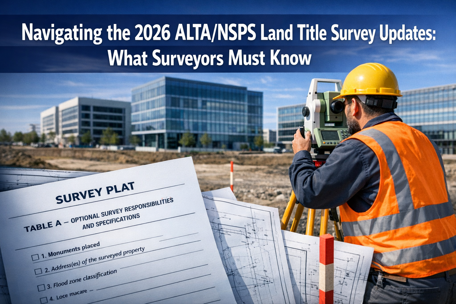
The clock is ticking. On February 23, 2026, the commercial real estate industry will experience a significant shift in land title survey standards that will affect every surveyor, title company, and CRE professional across the nation. Navigating the 2026 ALTA/NSPS Land Title Survey Updates: What Surveyors Must Know has become a critical priority for professionals who want to maintain compliance, avoid costly delays, and deliver accurate survey products to their clients.
The American Land Title Association (ALTA) and the National Society of Professional Surveyors (NSPS) have released comprehensive updates to their land title survey standards, marking the first major revision since 2021. These changes introduce substantial modifications to Table A requirements, documentation practices, and certification procedures that will fundamentally alter how surveyors approach their work.[1][2]
For surveyors and commercial real estate professionals, understanding these updates isn't optional—it's essential. The February 23, 2026 deadline means that any survey begun on or after this date must comply with the new standards, making immediate preparation critical.[1] This article breaks down every key change, provides actionable compliance checklists, and ensures you're fully prepared for the transition.
Key Takeaways
📋 Critical deadline: All surveys started on or after February 23, 2026 must reference and comply with the 2026 standards, completely replacing the 2021 version.
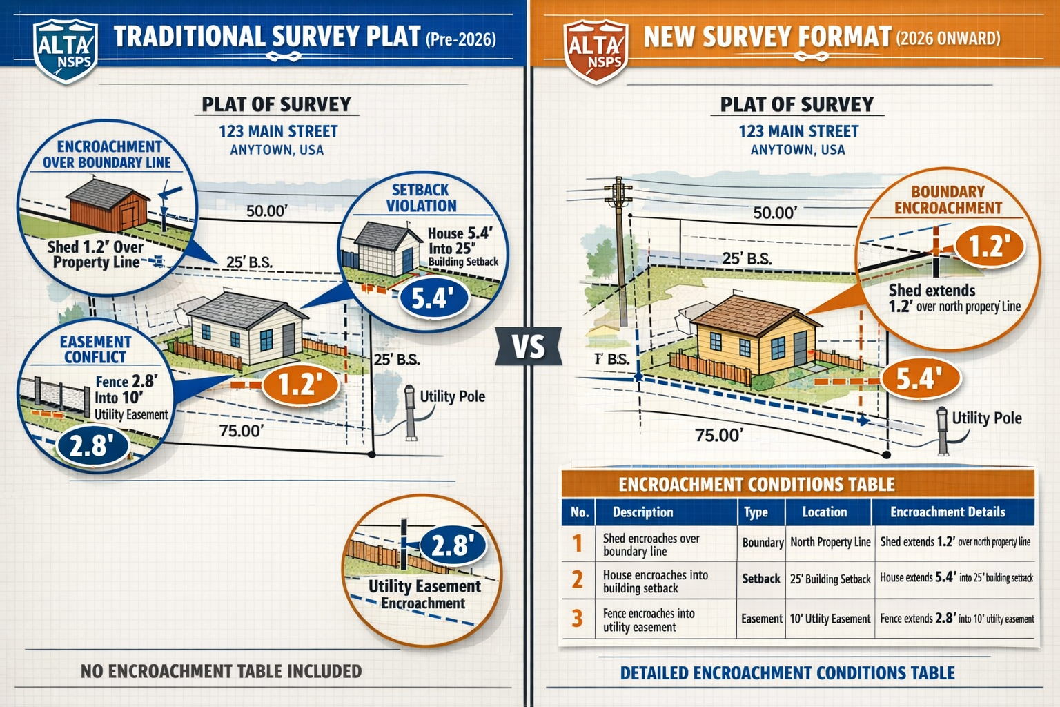
📊 New Table A Item 20: The most significant change introduces an optional requirement for surveyors to provide a comprehensive table of conditions and potential encroachments directly on the survey plat, eliminating back-and-forth revision requests.
🔄 Renumbered items: Former Table A Item 20 (negotiated items) becomes Item 21, requiring immediate updates to standard survey order request lists to prevent miscommunication.
📍 Enhanced documentation: New specific requirements for utility feature documentation, parol statement notation, and evidence of possession along property perimeters.
✅ Greater flexibility: Expanded language on acceptable fieldwork practices and imagery usage provides surveyors with more methodological options while maintaining quality standards.
Understanding the February 23, 2026 Deadline and Implementation Timeline

The February 23, 2026 effective date represents a hard cutoff for the surveying industry. Unlike some regulatory transitions that offer grace periods or phased implementation, this deadline is absolute. Any survey project that begins on or after this date must reference and comply with the 2026 ALTA/NSPS Land Title Survey Standards, completely replacing the 2021 version that has governed the industry for the past five years.[1][2]
What the Deadline Means for Your Practice
The implementation timeline creates several immediate action items for surveying professionals. First and foremost, surveyors must update their standard survey order request lists before the February deadline to reflect the new Table A item numbering and requirements.[2] This seemingly simple administrative task is crucial—failure to update these lists can lead to significant miscommunication between surveyors, clients, and title companies.
For projects currently in progress, the determining factor is the survey's start date. If fieldwork began before February 23, 2026, the 2021 standards continue to apply. However, any new engagement initiated on or after the deadline date must follow the 2026 standards, regardless of when the property transaction closes or when preliminary discussions occurred.[1]
Preparing Your Team for Transition
Professional surveying firms should implement a comprehensive transition strategy that includes:
- Staff training sessions covering all major changes in the 2026 standards
- Template updates for survey plats, certifications, and client communications
- Software configuration to accommodate new Table A Item 20 requirements
- Client notification about upcoming changes and potential impacts on timelines
- Quality control protocols ensuring compliance with refined definitions and documentation requirements
Many chartered surveyors across London and throughout the UK are already preparing their teams for similar standard updates, recognizing that professional development is essential for maintaining industry compliance.
Timeline Checklist for CRE Professionals
✅ By February 1, 2026: Review and understand all changes to the 2026 standards
✅ By February 15, 2026: Update all standard survey order request forms and templates
✅ By February 20, 2026: Complete staff training on new requirements
✅ February 23, 2026: Begin applying 2026 standards to all new survey projects
✅ March 2026 and beyond: Monitor compliance and refine processes based on initial implementation experience
The Game-Changing Table A Item 20: Encroachment Tables and Conditions
The introduction of new Table A Item 20 represents the most substantial change in Navigating the 2026 ALTA/NSPS Land Title Survey Updates: What Surveyors Must Know. This optional item fundamentally transforms how surveyors document and communicate potential encroachments, boundary conflicts, and property conditions to title insurers and clients.[1][2]
What Table A Item 20 Requires
When Table A Item 20 is selected by the client, surveyors must now provide a comprehensive table of conditions and potential encroachments directly on the face of the survey plat or map. This table must address specific observations including:
- Encroachments over boundary lines: Any improvements, structures, or features that cross property boundaries
- Encroachments into rights-of-way or easements: Improvements that extend into recorded easement areas or public rights-of-way
- Encroachments into setbacks: Structures or improvements that violate recorded or zoning-required setback lines
- Other conditions affecting the property: Additional observations that may impact title or property use
Critically, this new item requires surveyors to opine on their observations—not merely document them. This represents a shift from passive observation to active professional judgment about the significance and nature of potential encroachments.[2]
Why This Change Matters
Before the 2026 standards, title insurers frequently requested survey revisions to obtain encroachment statements and clarifications. This back-and-forth process created delays, increased costs, and frustrated all parties involved in commercial real estate transactions. The new Table A Item 20 eliminates this inefficiency by requiring comprehensive encroachment documentation upfront when requested.[1]
For surveyors, this change means:
- Enhanced professional responsibility: Providing opinions on encroachments requires careful analysis and clear communication
- Reduced revision requests: Comprehensive upfront documentation minimizes the need for supplemental information
- Standardized formatting: The table format ensures consistent presentation across different surveyors and projects
- Potential liability considerations: Professional opinions on encroachments may increase exposure to claims if inaccurate
Implementing Table A Item 20 in Your Practice
Successful implementation of the new encroachment table requirement demands careful planning. Surveyors should develop standardized templates that clearly present encroachment information in a tabular format on the survey plat. The table should include:
| Item | Location | Description | Encroachment Type | Measurement |
|---|---|---|---|---|
| Building corner | Northeast boundary | Brick wall foundation | Over boundary line | 0.3 feet |
| Driveway | Western easement | Asphalt paving | Into utility easement | 2.1 feet |
| Fence | Front setback | Chain link fence | Into required setback | 1.5 feet |
Professional surveyors should also establish clear internal protocols for reviewing and approving encroachment opinions before finalizing survey documents. This quality control step is essential given the professional judgment now required. Understanding what survey you need for different property types can help determine when Table A Item 20 should be recommended to clients.
Critical Table A Renumbering: Former Item 20 Becomes Item 21
A seemingly simple change carries significant practical implications: the former Table A Item 20 has been renumbered to Table A Item 21.[1][2] This renumbering accommodates the new encroachment table requirement but creates potential confusion if not properly communicated and implemented.
Understanding the Renumbering Impact
Table A Item 20 in the 2021 standards allowed for "Items to be shown per attached exhibit" or items negotiated between the surveyor and client. This catch-all provision enabled custom requirements specific to particular transactions or property types. In the 2026 standards, this same function now appears as Table A Item 21.[1]
The danger lies in outdated order forms and communications. If a client's standard survey order form still references "Table A Item 20" for negotiated items, but the surveyor interprets this under 2026 standards as the new encroachment table requirement, the resulting survey may not meet the client's actual needs—or may include unwanted additional work and expense.
Updating Standard Order Forms
Commercial real estate professionals and title companies must update their standard survey order request lists before the February 23, 2026 deadline. This update should include:
- Clear version identification: Specify "2026 ALTA/NSPS Standards" on all order forms
- Correct item numbering: Reference Item 21 (not Item 20) for negotiated or custom requirements
- Item 20 election: Explicitly state whether the new encroachment table (Item 20) is requested
- Transition period notation: During early 2026, consider including both item numbers with clarification to prevent confusion
Communication Protocols
Surveyors should implement verification procedures when receiving survey orders during the transition period. A simple confirmation email or phone call can prevent costly misunderstandings:
"We received your survey order dated [date]. To confirm: you are requesting the new 2026 Table A Item 20 encroachment table [YES/NO], and the following negotiated items under Table A Item 21: [list items]. Please confirm this understanding before we proceed."
This verification step takes minimal time but can prevent significant problems later in the transaction process. Professional practices offering commercial property surveying services should establish these protocols immediately.
Enhanced Utility Feature Documentation Requirements
The 2026 standards introduce specific distance requirements for documenting utility features, providing clear guidance that eliminates previous ambiguity about what must be shown on survey plats.[1]
New Distance-Based Requirements
Under the updated standards, surveyors must identify and document:
- Utility poles: Those located on the property or within 10 feet of the property boundary
- Other utility features: Those located on the property or within 5 feet of the property boundary
These specific distance thresholds replace previous language that left more room for interpretation. The standardization ensures consistency across different surveyors and projects while providing clear guidance for fieldwork planning.[1]
What Constitutes "Other Utility Features"
The term "other utility features" encompasses a wide range of infrastructure elements, including:
- Transformers and electrical equipment
- Utility pedestals and junction boxes
- Manholes and access covers
- Above-ground utility meters
- Communication equipment cabinets
- Water and gas valve boxes
- Fiber optic connection points
Surveyors must exercise professional judgment in determining which features meet the documentation threshold, considering both proximity and potential impact on property use and development.
Fieldwork Implications
These enhanced requirements affect fieldwork planning and execution. Survey crews must now:
- Extend search perimeters: Look beyond property boundaries to capture utility features within specified distances
- Document feature types: Clearly identify the nature and ownership of each utility feature
- Measure distances accurately: Verify that features fall within or outside the documentation thresholds
- Photograph evidence: Maintain photographic records of utility features for quality control and potential disputes
The refined requirements align with modern surveying practices while ensuring that title insurers and property buyers receive comprehensive information about utility infrastructure that could affect property use, development potential, or access rights.
Parol Statement Notation: Documenting Verbal Communications
One of the more nuanced additions to the 2026 standards is the requirement for surveyors to document parol statements—verbal communications from relevant landowners or occupants regarding title or boundary issues.[1][2]
What Parol Statements Include
Parol statements encompass verbal information provided by:
- Current property owners
- Adjacent property owners
- Tenants or occupants
- Property managers
- Other parties with knowledge of boundary or title issues
These statements might address:
- Historical boundary agreements or understandings
- Disputed property lines or corners
- Easement usage or restrictions
- Access rights or limitations
- Encroachment acknowledgments or disputes
Documentation Requirements
When surveyors receive verbal statements regarding title or boundary matters, the 2026 standards now require notation on the survey plat or in accompanying documentation. Best practices for documenting parol statements include:
Clear attribution: "Per statement by [name], [role] on [date]…"
Specific content: Document the substance of the statement without legal interpretation
Context: Note the circumstances under which the statement was made
Limitations: Include appropriate disclaimers that parol statements have not been independently verified
Professional Considerations
The parol statement requirement introduces important professional considerations. Surveyors should:
- Document contemporaneously: Record statements immediately when received, not from memory later
- Avoid legal interpretation: Report statements without opining on their legal validity
- Maintain neutrality: Present statements objectively without advocating for any party's position
- Consider verification: When practical, seek documentation or corroboration of significant statements
This requirement recognizes that verbal communications often contain valuable information about property boundaries and title issues, but it also requires surveyors to exercise professional judgment about what rises to the level of notation on official survey documents. Similar documentation practices apply to boundary dispute resolution work.
Evidence of Possession or Occupation Requirements
The 2026 standards clarify and expand requirements for documenting evidence of possession or occupation along property perimeters, removing previous distance limitations.[1]
What Changed
Under earlier standards, some surveyors interpreted possession evidence requirements as applying only to features within a certain proximity to boundary lines. The 2026 standards eliminate this ambiguity by requiring surveyors to note evidence of possession or occupation along the perimeter of the surveyed property regardless of proximity to boundary lines.[1]
Types of Possession Evidence
Evidence of possession or occupation that must be documented includes:
- Fencing: Any type of fence along or near property boundaries
- Landscaping: Maintained gardens, hedges, or other improvements suggesting occupancy
- Paving: Driveways, parking areas, or walkways indicating use patterns
- Signage: Posted signs indicating ownership, restrictions, or claims
- Structures: Sheds, garages, or other improvements near boundaries
- Use patterns: Mowed areas, stored materials, or other evidence of ongoing use
- Barriers: Walls, bollards, or other physical demarcations
Practical Implementation
This expanded requirement means surveyors must conduct thorough perimeter inspections regardless of where boundary lines are located. For large properties, this can significantly increase fieldwork time and complexity.
Surveyors should:
- Plan comprehensive perimeter walks: Budget adequate time for thorough boundary inspection
- Document systematically: Use consistent notation methods for possession evidence
- Photograph extensively: Maintain visual records of possession indicators
- Consider seasonal factors: Recognize that some possession evidence may be more visible during certain seasons
The requirement reflects the reality that possession evidence provides critical information about potential boundary disputes, adverse possession claims, or discrepancies between legal descriptions and actual occupation patterns.
Refined Relative Positional Precision (RPP) Definition
The 2026 standards include a refined definition of Relative Positional Precision (RPP) that provides additional clarity for professionals unfamiliar with advanced measurement techniques while continuing to align with accepted surveying practices.[1]
Understanding RPP
Relative Positional Precision refers to the value expressing the uncertainty in the position of a point on a survey relative to other points on the same survey. RPP is crucial for:
- Quality assurance: Demonstrating that survey measurements meet professional standards
- Legal defensibility: Providing objective evidence of measurement accuracy
- Client confidence: Assuring stakeholders that boundary determinations are reliable
- Professional standards: Meeting ALTA/NSPS requirements for measurement quality
What the Refinement Provides
The refined definition doesn't change the fundamental concept or calculation of RPP, but it does:
- Clarify terminology: Use more accessible language for non-specialists
- Provide context: Explain how RPP relates to survey quality and reliability
- Align with practice: Ensure the definition reflects current measurement technologies and methods
- Enhance understanding: Help title professionals and clients better grasp measurement precision concepts
Practical Application
Surveyors should ensure their measurement practices, equipment, and quality control procedures support appropriate RPP values for ALTA/NSPS surveys. This includes:
- Equipment calibration: Regular verification of total stations, GPS receivers, and other measurement instruments
- Methodology documentation: Clear records of measurement techniques and adjustment procedures
- Quality control checks: Independent verification of critical measurements
- Reporting standards: Consistent presentation of RPP values on survey plats
The refined definition supports the surveying profession's ongoing commitment to measurement quality while making these technical concepts more accessible to the broader commercial real estate community.
Expanded Fieldwork Practices and Methodology Flexibility
The 2026 standards introduce expanded language regarding acceptable fieldwork practices, providing surveyors with greater flexibility in methodologies while maintaining quality standards.[1]
New Flexibility Provisions
The updated standards specify that fieldwork may be completed using "practices generally recognized as acceptable" for ALTA/NSPS Land Title Surveys. This language acknowledges:
- Technological evolution: New measurement technologies and techniques continue to emerge
- Regional variations: Different geographic areas may have different optimal approaches
- Project-specific needs: Particular properties or transactions may benefit from specialized methods
- Professional judgment: Qualified surveyors should have discretion in selecting appropriate methods
What This Means for Surveyors
The expanded flexibility doesn't reduce quality expectations—it recognizes that multiple methodologies can achieve the same high-quality results. Acceptable practices might include:
- Traditional total station surveys: Conventional angle and distance measurements
- GPS/GNSS positioning: Satellite-based coordinate determination
- Hybrid approaches: Combining multiple technologies for optimal results
- Scanning technologies: Laser scanning or other advanced capture methods
- Photogrammetric methods: When appropriate and properly controlled
Documentation Requirements
With increased flexibility comes increased responsibility for documentation. Surveyors should clearly document:
- Methods employed: Specific techniques and technologies used
- Quality control procedures: How accuracy and reliability were verified
- Limitations or constraints: Any factors affecting methodology selection
- Professional justification: Why chosen methods are appropriate for the specific project
This flexibility provision recognizes that the surveying profession continues to evolve, and standards should accommodate innovation while maintaining the high-quality results that ALTA/NSPS surveys demand.
Enhanced Imagery Guidance and Requirements
The 2026 standards provide expanded acceptance of aerial or satellite imagery while establishing clear requirements for how such imagery may be used in ALTA/NSPS surveys.[2]
Imagery Usage Provisions
The updated standards recognize that high-quality aerial and satellite imagery can provide valuable information for survey projects, but they establish important safeguards:
- Written clarification required: Specific details of imagery use must be clarified in writing before deployment
- Quality standards: Imagery must meet appropriate resolution and accuracy requirements
- Date and source: The date of imagery capture and source must be documented
- Limitations acknowledged: Any limitations in imagery accuracy or currency must be noted
- Ground verification: Critical features must be verified through traditional fieldwork
When Imagery Is Appropriate
Aerial and satellite imagery can be particularly valuable for:
- Large properties: Where comprehensive ground coverage would be prohibitively expensive
- Preliminary research: Understanding property context before fieldwork
- Feature identification: Locating improvements, vegetation, or other features
- Change detection: Comparing current conditions to historical imagery
- Client visualization: Providing context for survey findings
Implementation Guidelines
Surveyors incorporating imagery into ALTA/NSPS surveys should:
- Obtain client approval: Secure written authorization before using imagery
- Document specifications: Record imagery date, source, resolution, and accuracy
- Verify critical features: Confirm important observations through ground measurements
- Note limitations: Clearly indicate what was determined from imagery versus fieldwork
- Maintain quality: Ensure imagery meets professional standards for the intended use
The enhanced imagery guidance reflects modern surveying practice while ensuring that imagery supplements rather than replaces the fundamental fieldwork that defines ALTA/NSPS surveys. Similar technological considerations apply to various property survey types.
Certification Flexibility for Lenders and Successors
The 2026 standards introduce important certification flexibility that accommodates modern financing structures and loan servicing practices.[1][2]
New Certification Options
The certification of survey plats or maps may now be extended to successors and assigns of the lender if requested by the client. This seemingly technical change addresses practical realities in commercial real estate financing:
- Loan sales: Commercial loans are frequently sold to other institutions
- Servicing transfers: Loan servicing often transfers to different companies
- Securitization: Many commercial loans are packaged into securities
- Portfolio transactions: Entire loan portfolios may change hands
Why This Matters
Previously, survey certifications were typically limited to specifically named parties. When loans transferred or were sold, questions arose about whether the certification extended to the new lender. This uncertainty created:
- Title insurance complications: Questions about coverage continuation
- Additional survey costs: Sometimes requiring new certifications or updated surveys
- Transaction delays: While parties resolved certification questions
- Legal ambiguity: Uncertainty about rights and responsibilities
Implementation Considerations
Surveyors should:
- Clarify at engagement: Determine whether successor certification is requested
- Update certification language: Modify standard certification text to include successors and assigns when appropriate
- Document the request: Maintain clear records of who requested successor certification
- Understand implications: Recognize that broader certification may have professional liability implications
This flexibility provision streamlines commercial real estate transactions while providing clarity about survey certification scope. It represents a practical adaptation to how commercial lending and loan servicing actually function in 2026.
Deletion of Adjoining Deeds Requirement
The 2026 standards delete the former requirement to provide copies of adjoining property deeds, acknowledging practical realities in many markets.[2]
What Was Removed
Previous standards included provisions requiring surveyors to obtain and review deeds for adjoining properties. This requirement aimed to help surveyors understand boundary relationships and identify potential conflicts. However, implementation proved problematic:
- Availability issues: In many jurisdictions, obtaining adjoining deeds is difficult or impossible
- Cost concerns: Acquiring multiple deeds can be expensive and time-consuming
- Practical limitations: For properties with many adjoining parcels, the requirement became unwieldy
- Questionable value: The information obtained often didn't significantly enhance survey quality
What Replaces It
Rather than requiring adjoining deed copies, the 2026 standards focus on:
- Boundary evidence: Documenting physical evidence of boundaries and occupation
- Record research: Reviewing available recorded documents affecting the subject property
- Professional judgment: Applying surveying expertise to boundary determination
- Client communication: Discussing boundary uncertainties or conflicts when identified
Practical Impact
The deletion of the adjoining deeds requirement:
- Reduces costs: Eliminates expense of obtaining multiple deed copies
- Speeds timelines: Removes a potentially time-consuming research step
- Focuses effort: Allows surveyors to concentrate on more valuable research and fieldwork
- Maintains quality: Doesn't reduce the quality or reliability of boundary determinations
Surveyors should still review adjoining deeds when readily available or when boundary questions arise, but the blanket requirement has been eliminated as impractical in many markets.
Monument Characteristics Clarification
The 2026 standards specify that "relationship to the ground" is an element of monument characteristics that must be documented.[1]
Understanding Monument Characteristics
Monuments are physical markers that establish or reference property boundaries. Proper documentation of monument characteristics is essential for:
- Boundary reestablishment: Enabling future surveyors to locate and use the same monuments
- Legal evidence: Providing detailed records for potential boundary disputes
- Quality assurance: Demonstrating thorough fieldwork and documentation
- Professional standards: Meeting ALTA/NSPS documentation requirements
What "Relationship to the Ground" Means
This clarification requires surveyors to document how monuments are positioned relative to the ground surface:
- Flush with ground: Monument top is level with surrounding terrain
- Above ground: Monument extends above the surface (specify height)
- Below ground: Monument is buried beneath the surface (specify depth)
- Disturbed or unstable: Monument has been displaced or is not firmly set
- Obscured: Monument is covered by pavement, vegetation, or other materials
Documentation Best Practices
Surveyors should document monument characteristics systematically:
Monument: 5/8" iron rod with cap stamped "RLS 12345"
Location: Northwest corner
Relationship to ground: Set flush with ground surface
Condition: Good, stable
Date set: Unknown (appears original to 1985 subdivision)
This level of detail ensures that future surveyors can confidently relocate and utilize the same monuments, maintaining boundary consistency over time. Similar documentation standards apply to property condition assessments.
Compliance Checklist for Surveyors: Navigating the 2026 ALTA/NSPS Land Title Survey Updates
To successfully navigate the 2026 ALTA/NSPS Land Title Survey Updates, surveyors should implement this comprehensive compliance checklist:
Pre-Deadline Preparation (Before February 23, 2026)
✅ Review complete 2026 standards document thoroughly
✅ Update all standard templates including survey plats, certifications, and order forms
✅ Revise Table A numbering in all client-facing documents (Item 20 vs. Item 21)
✅ Develop Table A Item 20 template for encroachment tables
✅ Train all survey staff on new requirements and procedures
✅ Update software and CAD standards to accommodate new requirements
✅ Revise quality control checklists to include 2026 standard provisions
✅ Notify regular clients about upcoming changes and potential impacts
Engagement and Planning Phase
✅ Verify standards version requested by client (2021 vs. 2026)
✅ Clarify Table A Item 20 selection (new encroachment table)
✅ Confirm Table A Item 21 requirements (formerly Item 20)
✅ Discuss imagery usage if appropriate and obtain written approval
✅ Determine certification scope including successor and assign coverage
✅ Establish parol statement protocols for the specific project
Fieldwork Phase
✅ Document utility poles on property or within 10 feet of boundaries
✅ Document other utility features on property or within 5 feet of boundaries
✅ Note evidence of possession along entire property perimeter regardless of distance
✅ Record monument characteristics including relationship to ground
✅ Document parol statements received from owners, occupants, or adjacent parties
✅ Photograph comprehensively all significant features and conditions
✅ Verify RPP compliance through appropriate measurement and adjustment procedures
Plat Preparation Phase
✅ Include encroachment table if Table A Item 20 was selected
✅ Provide professional opinions on encroachments, not just observations
✅ Document utility features with appropriate detail and accuracy
✅ Note possession evidence along perimeters
✅ Include parol statements with proper attribution and context
✅ Show monument characteristics including ground relationship
✅ Verify certification language matches client requirements including successors
Quality Control Phase
✅ Cross-check Table A items against client order and survey content
✅ Verify all 2026 requirements are addressed
✅ Review encroachment opinions for accuracy and clarity
✅ Confirm measurement quality meets RPP standards
✅ Check documentation completeness for all required elements
✅ Validate certification language is appropriate and accurate
Compliance Checklist for Title Companies and CRE Professionals
Title companies, lenders, and commercial real estate professionals also need to prepare for the 2026 standards:
Administrative Updates
✅ Revise standard survey order forms to reference 2026 standards
✅ Update Table A selections reflecting new Item 20 and renumbered Item 21
✅ Modify internal procedures for survey review and acceptance
✅ Train staff on new requirements and what to expect in surveys
✅ Update client communications about survey requirements and timelines
Order Placement
✅ Specify 2026 standards explicitly in survey orders
✅ Determine Item 20 need (encroachment table) based on transaction type
✅ Clarify Item 21 requirements for any negotiated or custom items
✅ Address certification scope including successor and assign coverage
✅ Discuss imagery usage if appropriate for the property type
Survey Review
✅ Verify standards compliance (2026 for surveys begun after February 23, 2026)
✅ Check encroachment table if Item 20 was requested
✅ Review utility documentation for completeness within specified distances
✅ Examine possession evidence notation along perimeters
✅ Confirm certification language matches requirements
✅ Validate Table A items against original order
Impact on Different Property Types
The 2026 ALTA/NSPS Land Title Survey Updates affect different property types in varying ways:
Commercial Office Properties
High impact areas:
- Encroachment tables (Item 20) particularly valuable for multi-tenant properties
- Utility documentation critical for properties with complex infrastructure
- Possession evidence important for properties with common areas or shared facilities
Recommended approach:
- Generally request Table A Item 20 for comprehensive encroachment documentation
- Budget additional time for thorough utility feature documentation
- Emphasize certification to successors given frequent loan transfers
Industrial and Warehouse Properties
High impact areas:
- Large perimeters require extensive possession evidence documentation
- Multiple utility services demand careful feature documentation
- Encroachments into setbacks common and require detailed analysis
Recommended approach:
- Plan for extended fieldwork time given property size
- Request Item 20 when zoning compliance is critical
- Document loading dock and yard areas thoroughly
Retail Properties
High impact areas:
- Parking lot improvements frequently encroach into easements
- Signage often creates setback issues requiring Item 20 documentation
- Access easements and cross-parking agreements create complex conditions
Recommended approach:
- Item 20 highly recommended for properties with shared parking or access
- Careful documentation of parol statements regarding parking and access rights
- Thorough utility documentation given extensive site improvements
Multi-Family Residential
High impact areas:
- Perimeter fencing and landscaping require possession documentation
- Recreational facilities may encroach into setbacks or easements
- Utility infrastructure often complex with multiple service providers
Recommended approach:
- Document all perimeter improvements regardless of distance from boundaries
- Request Item 20 when property has significant improvements near boundaries
- Verify all utility features within specified distances
Understanding how the 2026 updates affect different property types helps surveyors and clients make informed decisions about Table A selections and project planning. For guidance on selecting appropriate survey types for various properties, consult resources on determining survey needs.
Common Pitfalls and How to Avoid Them
As the industry transitions to the 2026 standards, several common pitfalls are likely to emerge:
Pitfall #1: Using Outdated Order Forms
Problem: Clients submit survey orders using 2021-era forms with incorrect Table A numbering
Solution:
- Update all standard forms before February 23, 2026
- Include version identification on all order forms
- Verify Table A items with clients when orders are received
- Maintain communication protocols during transition period
Pitfall #2: Misunderstanding Item 20 vs. Item 21
Problem: Confusion about which item number applies to which requirement
Solution:
- Create clear internal reference guides distinguishing Item 20 (encroachment table) from Item 21 (negotiated items)
- Confirm client intent when either item is selected
- Provide examples of what each item produces
- Document all clarifications in writing
Pitfall #3: Inadequate Encroachment Opinions
Problem: Providing observations without professional opinions when Item 20 is selected
Solution:
- Train staff on difference between observation and opinion
- Develop standard language for encroachment opinions
- Implement quality control review of all Item 20 tables
- Maintain professional liability insurance adequate for opinion-based work
Pitfall #4: Incomplete Utility Documentation
Problem: Missing utility features within specified distances
Solution:
- Establish systematic fieldwork procedures for utility documentation
- Use measurement tools to verify 5-foot and 10-foot thresholds
- Photograph all utility features for quality control
- Implement checklist-based field procedures
Pitfall #5: Overlooking Parol Statement Requirements
Problem: Failing to document significant verbal communications
Solution:
- Train field crews on parol statement requirements
- Provide forms or templates for documenting statements
- Establish protocols for determining what rises to documentation level
- Include parol statement review in quality control procedures
Pitfall #6: Ignoring Perimeter Possession Evidence
Problem: Limiting possession documentation to areas near boundary lines
Solution:
- Emphasize "regardless of proximity" language in standards
- Plan adequate time for complete perimeter inspection
- Document systematically using checklists or templates
- Review perimeter documentation during quality control
Professional Liability Considerations

The 2026 ALTA/NSPS Land Title Survey Updates introduce several professional liability considerations that surveyors should address:
Increased Opinion-Based Work
The new Table A Item 20 requires surveyors to provide professional opinions about encroachments, not merely document observations. This shift increases potential liability exposure if opinions prove incorrect or incomplete.
Risk mitigation strategies:
- Maintain appropriate professional liability insurance coverage
- Document the basis for all professional opinions
- Use qualified language when certainty is limited
- Implement thorough quality control review of all opinions
- Consider consultation with legal counsel on complex encroachment issues
Expanded Documentation Requirements
More comprehensive documentation requirements create more opportunities for errors or omissions. Missing a utility feature within the specified distance, overlooking possession evidence, or failing to document a parol statement could constitute professional negligence.
Risk mitigation strategies:
- Implement checklist-based fieldwork procedures
- Conduct thorough quality control review before finalizing surveys
- Maintain detailed field notes and photographic records
- Provide staff training on all new requirements
- Consider peer review for complex or high-value projects
Certification to Successors and Assigns
Extending certifications to successors and assigns of lenders potentially expands the universe of parties who might claim reliance on the survey, increasing exposure to claims.
Risk mitigation strategies:
- Understand the implications before agreeing to successor certification
- Ensure professional liability coverage extends to such certifications
- Maintain survey records for extended periods
- Document all project-specific limitations or qualifications
- Consider whether additional fees are appropriate for expanded certification
Standards of Care Evolution
As the 2026 standards become the norm, they will define the professional standard of care for ALTA/NSPS surveys. Failing to comply with these standards could constitute professional negligence.
Risk mitigation strategies:
- Implement comprehensive transition to 2026 standards by the deadline
- Maintain current knowledge of standard interpretations and best practices
- Participate in professional development and continuing education
- Document compliance with all standard requirements
- Seek guidance from professional organizations when questions arise
Professional surveyors should consult with their insurance carriers and legal advisors about how the 2026 standards affect their professional liability exposure and risk management strategies.
Technology Solutions for 2026 Compliance
Several technology solutions can help surveyors efficiently comply with the 2026 ALTA/NSPS Land Title Survey Updates:
Survey Software Updates
Major survey software providers are releasing updates to accommodate the 2026 standards:
- Template modifications: Updated plat templates with proper Table A numbering
- Encroachment table tools: Automated or semi-automated table generation for Item 20
- Utility documentation: Enhanced symbology and annotation for utility features
- Quality control checklists: Built-in verification of 2026 requirement compliance
Mobile Data Collection
Field data collection apps can streamline documentation of new requirements:
- Utility feature capture: GPS-enabled documentation of poles and features with automatic distance calculation
- Photo integration: Linking photographs to specific features and observations
- Parol statement recording: Voice-to-text or structured forms for documenting verbal communications
- Possession evidence logging: Systematic documentation of perimeter conditions
CAD and Drafting Tools
Enhanced drafting tools support efficient plat preparation:
- Encroachment table automation: Tools that compile observations into properly formatted tables
- Distance verification: Automated checking of utility feature distances
- Monument symbology: Updated symbols and annotation for monument characteristics including ground relationship
- Quality control scripts: Automated verification of standard requirement compliance
Project Management Systems
Integrated project management platforms help ensure nothing falls through the cracks:
- Checklist integration: 2026-compliant checklists at each project phase
- Template management: Version-controlled templates ensuring current standards are used
- Client communication: Automated notifications about standard changes and requirements
- Quality assurance workflows: Multi-stage review processes for complex requirements
Investing in appropriate technology solutions can significantly reduce the administrative burden of transitioning to the 2026 standards while improving quality and reducing error risk.
Training and Professional Development Resources
Successful navigation of the 2026 ALTA/NSPS Land Title Survey Updates requires ongoing professional development:
Professional Organization Resources
NSPS (National Society of Professional Surveyors)
- Webinars on 2026 standard changes
- Interpretation guidance documents
- Member forums for discussing implementation questions
- Continuing education courses
ALTA (American Land Title Association)
- Joint guidance with NSPS on standard interpretation
- Title industry perspective on survey requirements
- Best practices documentation
- Industry conferences and workshops
State and Regional Associations
Local professional surveying associations often provide:
- State-specific implementation guidance
- Regional networking and knowledge sharing
- Continuing education opportunities
- Practice management resources
Commercial Training Providers
Several organizations offer specialized training on ALTA/NSPS surveys:
- In-person workshops on 2026 changes
- Online courses with continuing education credit
- Custom training for surveying firms
- Certification programs for ALTA/NSPS survey specialists
Internal Training Programs
Surveying firms should develop internal training including:
- Comprehensive review of all 2026 changes
- Hands-on practice with encroachment table preparation
- Field crew training on new documentation requirements
- Quality control reviewer training on verification procedures
- Case studies and example projects
Ongoing professional development ensures that surveyors not only comply with the 2026 standards but understand the reasoning behind the changes and can apply them effectively in diverse situations.
Regional Variations and Considerations
While ALTA/NSPS standards are national, implementation can vary by region based on local practices, recording systems, and legal frameworks:
Recording System Differences
Title theory vs. lien theory states: Different approaches to property interests may affect how encroachments and easements are documented and opined upon.
Recording requirements: Some jurisdictions have specific requirements for survey recording that may interact with ALTA/NSPS standards.
Public records access: Availability of adjoining property information varies significantly by jurisdiction, affecting research capabilities.
Regional Practice Variations
Monument types: Different regions use different monument types and setting practices, affecting documentation approaches.
Utility infrastructure: Regional differences in utility placement (overhead vs. underground) affect documentation requirements.
Climate considerations: Seasonal variations in vegetation and ground conditions affect fieldwork planning and possession evidence visibility.
Local Regulatory Environments
Zoning administration: Different jurisdictions have different approaches to setback enforcement and encroachment tolerance.
Building codes: Local building codes may create different encroachment scenarios requiring documentation.
Easement practices: Regional variations in utility easement practices affect how encroachments are evaluated.
Surveyors should understand how regional factors interact with the national ALTA/NSPS standards to provide appropriate service in their markets. Professional practices operating across multiple regions, such as chartered surveyors in Surrey or Central London, must adapt their procedures to local conditions while maintaining standard compliance.
Cost and Timeline Implications
The 2026 ALTA/NSPS Land Title Survey Updates will affect both the cost and timeline for completing surveys:
Cost Factors
Increased fieldwork time: More comprehensive utility documentation and perimeter possession evidence documentation will increase field time for many projects.
Enhanced research: While adjoining deed requirements were deleted, other documentation requirements may increase research time.
Table A Item 20 preparation: Creating comprehensive encroachment tables with professional opinions requires additional analysis and drafting time.
Quality control: More complex requirements demand more thorough quality control review, adding time and cost.
Training and implementation: Firms will incur costs for staff training, template development, and software updates.
Timeline Considerations
Planning phase: Additional time may be needed to clarify Table A selections and requirements with clients.
Fieldwork phase: Expect 10-20% longer field time for properties with significant utility infrastructure or complex perimeter conditions.
Drafting phase: Encroachment table preparation and enhanced documentation may add 1-2 days to drafting time.
Review phase: More comprehensive quality control review may extend timelines by several days.
Communication phase: More back-and-forth with clients about new requirements may affect overall project duration.
Managing Expectations
Surveyors should:
- Update fee schedules to reflect increased time and complexity
- Communicate timeline impacts to clients early in engagement
- Build efficiency through standardized procedures and technology
- Adjust project scheduling to accommodate new requirements
- Educate clients about value provided by enhanced documentation
While the 2026 standards will increase survey costs and timelines for some projects, the enhanced documentation and reduced revision requests should provide offsetting value to clients and streamline overall transaction processes.
Conclusion: Preparing for Success with the 2026 Standards
Navigating the 2026 ALTA/NSPS Land Title Survey Updates: What Surveyors Must Know requires comprehensive preparation, systematic implementation, and ongoing professional development. The February 23, 2026 deadline is rapidly approaching, making immediate action essential for all surveying professionals and commercial real estate stakeholders.
The changes introduced in the 2026 standards—particularly the new Table A Item 20 encroachment table requirement, renumbered Item 21, enhanced utility documentation requirements, parol statement notation mandate, and expanded possession evidence requirements—represent significant shifts in how ALTA/NSPS surveys are conducted and documented. These changes aren't merely administrative updates; they fundamentally alter surveyor responsibilities and deliverables.
Key Success Factors
Early preparation: Don't wait until February 2026 to begin your transition. Update templates, train staff, and revise procedures now.
Clear communication: Establish robust communication protocols with clients to prevent misunderstandings about Table A numbering and requirements.
Quality focus: Implement comprehensive quality control procedures that verify compliance with all 2026 requirements.
Technology investment: Leverage software, mobile apps, and project management tools to streamline compliance and reduce error risk.
Professional development: Commit to ongoing learning about standard interpretation and best practices.
Risk management: Review professional liability coverage and implement appropriate risk mitigation strategies.
Actionable Next Steps
For surveyors preparing for the 2026 standards transition:
- This week: Review the complete 2026 ALTA/NSPS standards document thoroughly
- This month: Update all templates, forms, and standard procedures
- Before February 1, 2026: Complete comprehensive staff training on all changes
- Before February 15, 2026: Test new procedures on sample projects
- February 23, 2026 and beyond: Implement 2026 standards on all new survey projects
For title companies and CRE professionals:
- This week: Review your standard survey order forms and update Table A numbering
- This month: Educate internal staff on what to expect in 2026-compliant surveys
- Before February 1, 2026: Communicate with surveyor partners about transition readiness
- Before February 15, 2026: Update internal review procedures and checklists
- February 23, 2026 and beyond: Verify that all new survey orders specify 2026 standards
The 2026 ALTA/NSPS Land Title Survey Standards represent a thoughtful evolution of industry best practices, addressing practical challenges while maintaining the high-quality standards that make ALTA/NSPS surveys the gold standard for commercial real estate transactions. By preparing systematically, communicating clearly, and committing to professional excellence, surveyors and CRE professionals can successfully navigate these updates and continue delivering the accurate, comprehensive survey products that support sound real estate decisions.
The deadline is fixed. The requirements are clear. The time to prepare is now. Whether you're a surveyor conducting fieldwork, a title professional reviewing survey documents, or a CRE professional ordering surveys for transactions, understanding and implementing the 2026 ALTA/NSPS Land Title Survey Updates is essential for professional success in the evolving commercial real estate landscape of 2026 and beyond.
For additional guidance on survey requirements and professional surveying services, explore resources on understanding survey types and professional surveying practices.
References
[1] Key Updates To The 2026 Alta Nsps Land Title Survey Standards – https://ltaal.org/key-updates-to-the-2026-alta-nsps-land-title-survey-standards/
[2] Nsps Land Title – https://www.parkerpoe.com/news/2026/02/key-takeaways-from-the-2026-alta/nsps-land-title