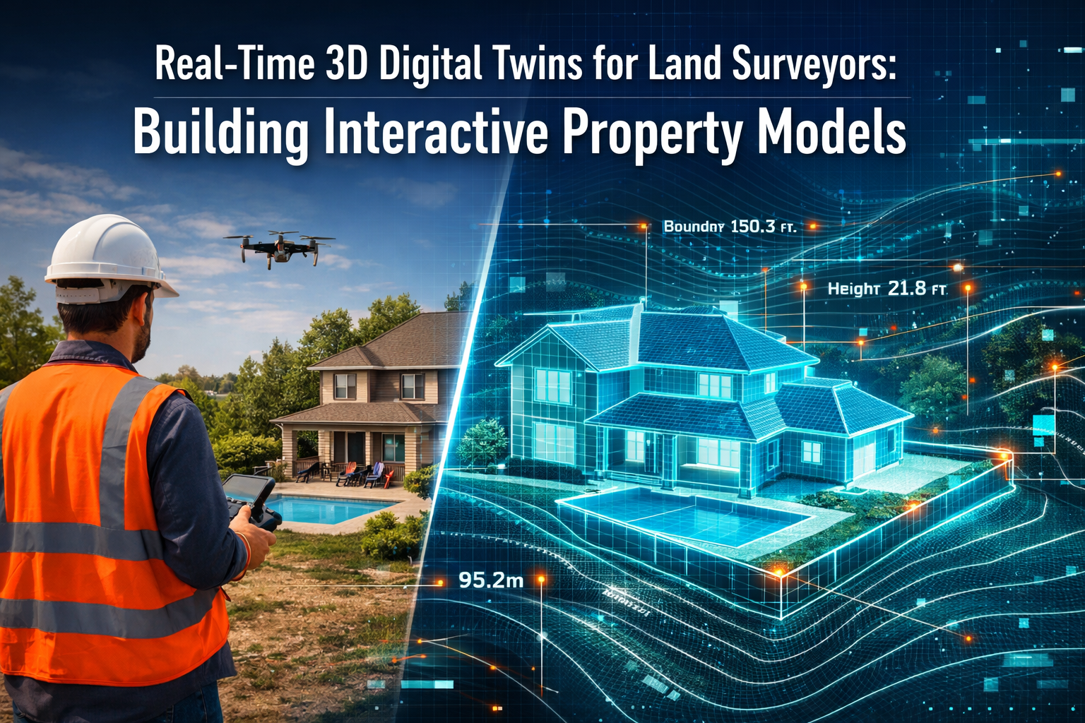
In 2026, the surveying profession stands at a transformative crossroads. Gone are the days when land surveyors delivered static PDF reports and 2D CAD drawings that quickly became outdated. Today's property stakeholders demand something far more powerful: Real-Time 3D Digital Twins for Land Surveyors: Building Interactive Property Models that update continuously, simulate environmental conditions, and enable instant collaboration across project teams. 🚀
These living digital replicas represent more than technological novelty—they fundamentally reshape how surveyors capture, analyze, and deliver spatial intelligence. When a developer can visualize slope erosion over the next decade, or an engineer can stress-test infrastructure within an interactive model before breaking ground, the surveyor's role evolves from data collector to strategic advisor.
The shift toward Real-Time 3D Digital Twins for Land Surveyors: Building Interactive Property Models reflects broader industry transformation. Reality capture technology has transitioned from specialized service to mainstream practice, with user-friendly tools and cloud platforms making implementation accessible to surveying firms of all sizes.[4] This article examines how continuous-updating 3D twins enable developers to simulate environmental conditions and collaborate instantly, while providing practical tutorials on cloud integration for surveyors ready to embrace this revolution.
Key Takeaways
- Digital twins enable four critical predictive simulations: slope erosion projections, water flow modeling, vegetation pattern analysis, and infrastructure stress testing—all within a single interactive model accessible to developers, engineers, and planners.[1]
- Multi-sensor autonomous drones consolidate data capture: Modern UAV systems carry synchronized LiDAR, photogrammetry, multispectral, and thermal sensors that work together in single flights, replacing multiple site visits with comprehensive autonomous data collection.[1]
- Cloud-based platforms revolutionize project delivery: Interactive browser-based 3D models with real-time syncing, integrated communication, and instant file sharing replace traditional static deliverables, transforming client collaboration.[1]
- AI automation accelerates workflows dramatically: Artificial intelligence systems now instantly classify terrain, identify markers, flag anomalies, and generate preliminary surface models, reducing project turnaround time while allowing surveyors to focus on expertise application.[1]
- Interoperability drives ecosystem integration: Enhanced data exchange between software platforms enables seamless handoffs to BIM systems, machine control equipment, and GIS databases, multiplying the value of surveying data throughout project lifecycles.[4]
Understanding Real-Time 3D Digital Twins for Land Surveyors: Building Interactive Property Models
What Makes a Digital Twin "Real-Time"?
A digital twin represents a virtual replica of a physical asset, environment, or system. For land surveyors, this means creating precise three-dimensional models of properties, terrain, and infrastructure. The "real-time" designation distinguishes these models from static representations through three defining characteristics:
- Continuous data integration from sensors, drones, and monitoring equipment
- Instant updates that reflect current conditions rather than historical snapshots
- Live interaction capabilities allowing multiple users to manipulate, query, and simulate within the model simultaneously
Traditional surveying deliverables captured a single moment in time. A topographic survey conducted in March remained frozen at that March state, even when conditions changed dramatically by June. Real-time digital twins fundamentally alter this paradigm by incorporating ongoing data streams that keep the model current.[6]
The technology underlying these systems combines point cloud data from LiDAR scanning, photogrammetric imagery from drone cameras, geospatial coordinates from GPS/GNSS receivers, and sensor telemetry from environmental monitors. Cloud computing platforms process this information continuously, updating the 3D model as new data arrives.[3]
The Four Pillars of Interactive Property Models
Real-Time 3D Digital Twins for Land Surveyors: Building Interactive Property Models rest on four foundational capabilities that distinguish them from conventional survey outputs:
| Pillar | Traditional Survey | Real-Time Digital Twin |
|---|---|---|
| Visualization | 2D plans, cross-sections | Fully navigable 3D environment with photorealistic textures |
| Simulation | Static calculations | Dynamic modeling of erosion, flooding, vegetation, structural stress[1] |
| Collaboration | Email attachments, markups | Cloud-based simultaneous access with integrated communication |
| Updates | New survey required | Continuous refresh from ongoing data capture |
The simulation capabilities deserve particular attention. Digital twins enable four types of predictive modeling that transform decision-making for property development:[1]
- 🌊 Water flow simulations showing drainage patterns, flood zones, and stormwater management effectiveness
- ⛰️ Slope erosion projections modeling soil stability and landscape changes over time
- 🌳 Vegetation pattern analysis tracking growth, seasonal changes, and environmental impact
- 🏗️ Infrastructure stress testing evaluating structural loads, settlement, and performance under various conditions
These simulations run within the same interactive model that houses the base survey data, allowing developers, engineers, and planners to explore scenarios without commissioning separate studies.[1]
How Digital Twins Integrate with Modern Surveying Workflows
The creation of Real-Time 3D Digital Twins for Land Surveyors: Building Interactive Property Models doesn't replace traditional surveying skills—it amplifies them. Chartered surveyors still establish control networks, verify boundary markers, and ensure positional accuracy. The difference lies in how that foundational work feeds into broader systems.
Modern workflows typically follow this sequence:
- Initial data capture using multi-sensor platforms (drones, mobile mapping, terrestrial scanners)
- AI-powered processing that classifies terrain, identifies features, and generates preliminary models[1]
- Surveyor validation applying professional judgment to verify accuracy and resolve ambiguities
- Cloud platform upload making the model accessible through web browsers
- Continuous monitoring with periodic drone flights or sensor feeds updating specific areas
- Simulation integration adding predictive modeling layers for client decision support
This workflow represents a significant evolution from traditional practice. Where surveyors once delivered final products at project completion, they now establish living systems that provide ongoing value throughout property lifecycles.[4]
Technology Stack: Building Blocks of Real-Time Digital Twins
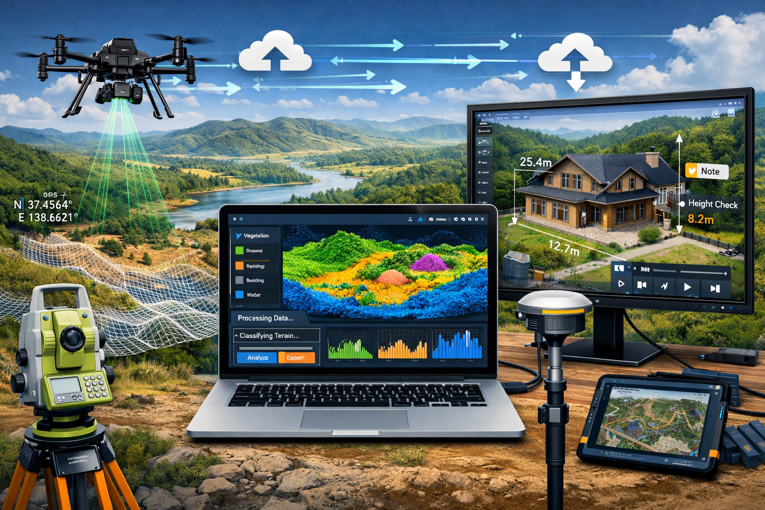
Multi-Sensor Autonomous Drone Systems
The foundation of efficient digital twin creation lies in comprehensive data capture during single site visits. Modern UAV systems achieve this through synchronized multi-sensor payloads that work together:[1]
LiDAR scanners emit laser pulses to create precise point clouds, penetrating vegetation to capture ground surfaces beneath tree canopy. These systems generate millions of points per second, each with accurate X, Y, Z coordinates.
Photogrammetry cameras capture overlapping high-resolution images that software processes into 3D models with photorealistic textures. The visual detail complements LiDAR's geometric precision.
Multispectral sensors record light beyond human vision, revealing vegetation health, soil moisture, and material composition invisible to standard cameras.
Thermal imaging units detect temperature variations that indicate drainage issues, structural problems, or environmental conditions requiring attention.
The true innovation lies in autonomous flight capabilities that optimize data collection. Surveyors plan flight paths using predictive modeling, and drones automatically adjust altitude, angle, and sensor selection for optimal readings.[1] This consolidates work that previously required multiple site visits with different equipment.
For specialized applications like roof surveys, these drone systems provide safe, detailed inspection capabilities without requiring physical access to dangerous elevations.
AI-Driven Data Processing and Classification
Raw sensor data arrives in overwhelming volumes—a single drone flight generates gigabytes of point clouds and imagery. Manual processing once consumed days or weeks of surveyor time. Artificial intelligence systems now automate the heavy lifting:[1][2]
- Terrain classification algorithms instantly distinguish ground from vegetation, buildings, and infrastructure
- Feature recognition identifies survey markers, property boundaries, utility structures, and landmarks
- Anomaly detection flags inconsistencies, errors, or unexpected conditions requiring expert review
- Surface model generation creates preliminary digital elevation models and 3D meshes
This automation doesn't eliminate surveyor expertise—it redirects it. Rather than manually sorting millions of points, professionals focus on validation, interpretation, and client consultation. The AI handles repetitive tasks; surveyors apply judgment to complex situations.[2]
The efficiency gains prove substantial. Projects that required two weeks of processing time in 2024 now complete in hours, dramatically reducing turnaround time while maintaining or improving accuracy.[1]
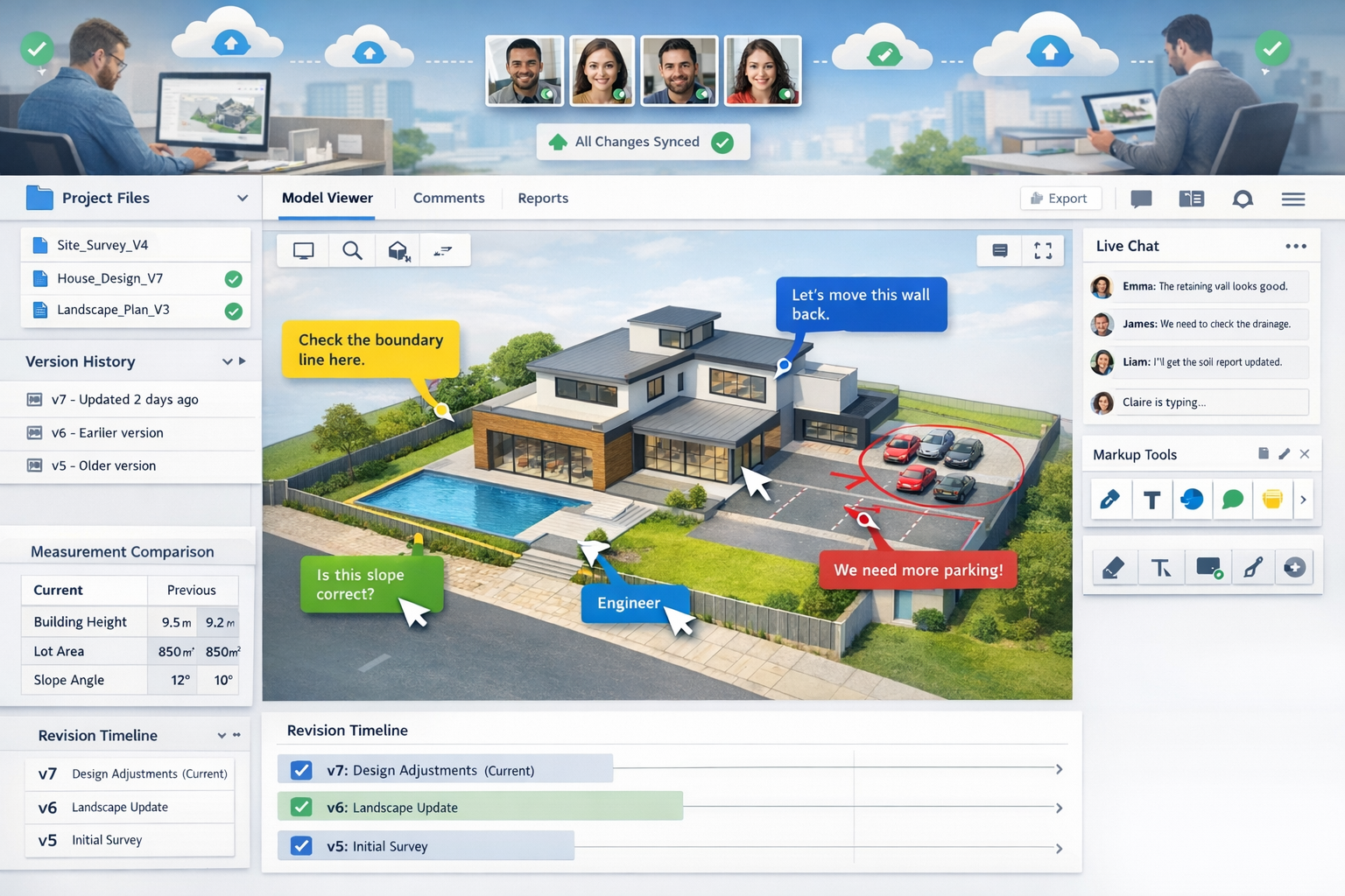
Cloud-Based Collaboration Platforms
The delivery mechanism for Real-Time 3D Digital Twins for Land Surveyors: Building Interactive Property Models represents as significant a shift as the data capture technology. Cloud platforms have revolutionized how surveyors share work with clients and project teams:[1]
Browser-based 3D viewers eliminate software installation requirements. Developers, architects, and engineers access full interactive models through web browsers on any device—desktop, tablet, or mobile.
Real-time revision syncing ensures all stakeholders view current data. When surveyors upload updates, changes appear instantly across all user sessions.
Integrated communication tools attach comments, markups, and discussions directly to specific model locations. Rather than emailing screenshots with descriptions, team members annotate the model itself.
Granular access controls allow surveyors to share different model versions or data layers with different stakeholders, protecting sensitive information while enabling collaboration.
Version history tracking maintains complete records of model evolution, supporting expert witness requirements and dispute resolution.
These platforms transform static deliverables into living project hubs that serve as single sources of truth throughout development, construction, and asset management phases.[3]
Integration with BIM and GIS Systems
The value of digital twins multiplies when they integrate seamlessly with broader technology ecosystems. Two integration pathways prove particularly important:
Building Information Modeling (BIM) connectivity allows surveying data to feed directly into architectural and engineering workflows. Commercial property surveyors increasingly collaborate with design teams, providing geospatial foundations for BIM models that enhance project planning and reduce construction conflicts.[1][4]
Geographic Information Systems (GIS) integration addresses the infrastructure management challenges facing municipalities and asset owners. Survey data feeds comprehensive 3D GIS platforms that provide ongoing value beyond traditional project boundaries, supporting asset lifecycle management for aging infrastructure.[4]
Industry experts identify improved interoperability as a defining trend of 2026. Construction technology vendors accelerate efforts to enhance data exchange between software ecosystems, allowing teams to share project information regardless of which specific platforms they deploy.[4] For surveyors, this means their digital twin data reaches more stakeholders and delivers greater value across longer timeframes.
Implementing Real-Time 3D Digital Twins: Practical Guide for Surveyors
Step 1: Assessing Project Suitability and Client Needs
Not every surveying assignment requires a full real-time digital twin. The technology delivers maximum value for specific project types:
✅ Ideal candidates:
- Large-scale developments requiring ongoing monitoring
- Complex terrain with erosion, drainage, or stability concerns
- Projects with multiple stakeholder groups needing collaborative access
- Properties undergoing phased construction or renovation
- Assets requiring long-term management and maintenance planning
❌ Less suitable projects:
- Simple boundary surveys with straightforward deliverables
- One-time assessments without ongoing monitoring needs
- Small properties where traditional methods prove more cost-effective
- Clients lacking technical infrastructure to access cloud platforms
The decision framework should consider project duration, stakeholder complexity, and long-term value. A homebuyer report for a residential purchase differs fundamentally from a multi-year commercial development requiring continuous spatial intelligence.
Client consultation proves essential. Surveyors should explain digital twin capabilities, demonstrate platform interfaces, and align deliverables with actual decision-making needs rather than pursuing technology for its own sake.
Step 2: Selecting Hardware and Software Platforms
Building an effective digital twin capability requires strategic technology investments across three categories:
Data Capture Equipment:
- Entry level: DJI Phantom/Mavic drones with photogrammetry capabilities (£1,000-£3,000)
- Professional: Specialized surveying drones with RTK/PPK GPS (£8,000-£25,000)
- Advanced: Multi-sensor payloads with LiDAR + cameras (£50,000-£150,000)
- Terrestrial: Ground-based laser scanners for detailed structure capture (£15,000-£100,000)
Processing Software:
- Photogrammetry: Pix4D, Agisoft Metashape, RealityCapture for point cloud generation
- Point Cloud Processing: CloudCompare, Trimble RealWorks, Leica Cyclone for classification
- AI Classification: Specialized tools for automated feature extraction and terrain analysis
- Model Optimization: Software to reduce file sizes while maintaining detail for web delivery
Cloud Platforms:
- Specialized Surveying: Trimble Connect, Bentley iTwin, Autodesk BIM 360
- General 3D Hosting: Sketchfab, Matterport, Cupix for simpler visualization needs
- Custom Development: APIs for building proprietary client portals with specific functionality
The optimal configuration depends on project types, budget, and technical expertise. Many firms adopt phased implementation strategies, starting with photogrammetry-capable drones and cloud hosting, then adding LiDAR and AI processing as capabilities mature.
Step 3: Data Capture Best Practices
Successful digital twin creation begins with comprehensive, high-quality data collection. Several principles ensure optimal results:
Flight Planning Precision:
- Calculate appropriate overlap percentages (typically 70-80% forward, 60-70% side) for photogrammetry
- Adjust altitude based on required ground sample distance (GSD)—lower flights capture more detail but require more images
- Plan multiple flight angles including nadir (straight down) and oblique (angled) for complete building facades
- Account for lighting conditions—overcast days often produce better results than harsh direct sunlight
- Establish ground control points with survey-grade GPS for absolute accuracy
Multi-Sensor Coordination:
When deploying combined LiDAR and photogrammetry systems, synchronize capture to ensure geometric and visual data align perfectly. This requires careful sensor calibration and time-stamping of all measurements.
Environmental Considerations:
- Schedule flights during optimal vegetation states (leaf-off for terrain, leaf-on for landscape analysis)
- Monitor weather forecasts to avoid wind, precipitation, or temperature extremes
- Consider seasonal variations if establishing baseline for ongoing monitoring
Safety and Compliance:
Maintain current certifications, observe airspace restrictions, and conduct thorough site risk assessments. The efficiency of drone technology never justifies compromising safety protocols.
Step 4: Cloud Integration Tutorial
Transitioning from local processing to cloud-based delivery represents a significant workflow change. This tutorial outlines the essential steps:
A. Platform Selection and Setup
Choose a cloud platform matching your project requirements and client technical capabilities. For this example, we'll use a typical surveying-focused platform:
- Create organizational account with appropriate subscription tier
- Configure user roles and permissions (admin, editor, viewer)
- Establish project structure with folders for different sites or phases
- Set up client access portals with custom branding if desired
B. Data Preparation and Upload
Raw point clouds and models require optimization before cloud deployment:
- Clean point cloud data: Remove noise, classify ground points, filter vegetation
- Generate mesh models: Convert point clouds to triangulated surfaces
- Apply textures: Drape photogrammetry imagery onto geometry for photorealistic appearance
- Optimize file sizes: Reduce polygon counts while maintaining visual quality
- Create LOD (Level of Detail) versions: Multiple resolution versions for performance
Upload to platform using dedicated desktop applications or web interfaces. Large datasets benefit from batch upload tools and background processing that doesn't block other work.
C. Model Configuration
Configure the uploaded model for optimal user experience:
- Set default viewpoints that orient users to the property
- Define measurement units and coordinate systems
- Enable measurement tools for distance, area, and volume calculations
- Add annotation layers for survey markers, boundaries, and features
- Configure simulation overlays for erosion, flooding, or other predictive models
D. Stakeholder Access and Training
Provide clients and team members with appropriate access:
- Generate shareable links with permission levels (view-only vs. edit)
- Create quick-start guides showing basic navigation and tools
- Conduct walkthrough sessions demonstrating key features
- Establish feedback channels for questions and issues
E. Continuous Updates
Implement workflows for ongoing model refresh:
- Schedule periodic drone flights for changed areas
- Process incremental updates rather than complete model rebuilds
- Configure automated notifications when new data uploads
- Maintain version history documenting model evolution
This cloud-first approach transforms surveying from periodic service to continuous spatial intelligence partnership, particularly valuable for commercial building surveys and long-term development projects.
Step 5: Adding Predictive Simulation Capabilities
The true power of Real-Time 3D Digital Twins for Land Surveyors: Building Interactive Property Models emerges when predictive simulations layer onto base survey data. Four simulation types prove particularly valuable:[1]
Water Flow and Drainage Modeling:
Import digital elevation models into hydrological simulation software that calculates:
- Surface runoff patterns during rainfall events
- Accumulation zones where water collects
- Optimal drainage system placement
- Flood risk areas under various storm scenarios
Export results as color-coded overlays that display within the digital twin, allowing developers to visualize drainage solutions before construction.
Slope Stability and Erosion Analysis:
Combine terrain geometry with soil data to model:
- Erosion susceptibility across different slope angles
- Projected landscape changes over 5, 10, or 20-year periods
- Stabilization requirements for cut and fill operations
- Vegetation effectiveness for erosion control
Time-slider controls let stakeholders explore erosion progression, supporting informed mitigation decisions.
Vegetation Growth Patterns:
Integrate multispectral data with growth models predicting:
- Tree canopy expansion affecting structures or views
- Seasonal vegetation changes impacting site aesthetics
- Landscape maturation for development marketing
- Environmental impact of vegetation removal or addition
Infrastructure Stress Testing:
For properties with existing or planned structures, finite element analysis simulates:
- Building settlement on various soil conditions
- Structural loads and stress concentrations
- Foundation performance under different scenarios
- Long-term infrastructure degradation
These simulations transform digital twins from documentation tools into decision support systems. Rather than simply showing current conditions, surveyors provide actionable intelligence about future scenarios.
Real-World Applications and Case Studies

Large-Scale Residential Development
A 50-hectare residential development in Surrey required comprehensive terrain analysis for phased construction over five years. Traditional surveying approaches would have delivered periodic snapshots, requiring new surveys as each phase commenced.
Instead, the surveying team implemented a real-time digital twin with quarterly drone updates. The continuous model enabled:
- Drainage optimization through water flow simulations that identified three problematic accumulation zones before infrastructure installation
- Cut-and-fill balancing across phases, reducing earthmoving costs by 18% through better material management
- Stakeholder collaboration with architects, engineers, and local planning authorities all accessing the same cloud model
- Marketing assets providing prospective buyers with interactive 3D visualization of completed development
The project demonstrated how Real-Time 3D Digital Twins for Land Surveyors: Building Interactive Property Models deliver value throughout multi-year developments, not just at project initiation. The continuous monitoring approach proved particularly valuable when unexpected ground conditions emerged during Phase 2—the existing digital twin provided immediate context for remediation planning.
Infrastructure Asset Management
A municipal authority managing aging road networks across multiple districts faced mounting maintenance challenges. Traditional survey approaches captured conditions at specific moments but provided no ongoing monitoring capability.
Implementing mobile mapping systems with 3D cameras for digital twin creation[5], the authority established continuous monitoring of:
- Pavement condition and deterioration rates
- Drainage infrastructure performance
- Vegetation encroachment on roadways
- Utility asset locations and conditions
The GIS-centric digital twin approach addressed infrastructure lifecycle management challenges by providing spatial intelligence that extends beyond individual project boundaries.[4] Maintenance teams accessed current conditions through mobile devices, and predictive modeling identified high-priority intervention areas before failures occurred.
This application exemplifies the trend toward asset lifecycle management that Trimble experts identify as defining the 2026 surveying landscape.[4]
Commercial Property Valuation
Commercial property surveyors increasingly leverage digital twins for valuation reports that provide clients with unprecedented detail and confidence.
A recent office building valuation in central London incorporated:
- Complete 3D model with accurate floor areas and volume calculations
- Thermal imaging overlay identifying energy efficiency issues
- Structural condition assessment from terrestrial laser scanning
- Comparable property analysis with interactive 3D visualization
The digital twin approach delivered quantifiable accuracy improvements while providing clients with interactive models supporting their own due diligence. The same technology proves valuable for Red Book valuations and specialized assessments like reinstatement cost valuations.
Boundary Dispute Resolution
Traditional boundary disputes often devolve into competing interpretations of 2D plans and written descriptions. Digital twins provide objective spatial context that facilitates resolution.
A recent boundary dispute case involved conflicting fence line claims between neighboring properties. The surveyor created a comprehensive digital twin incorporating:
- Historical aerial imagery showing fence evolution over decades
- Precise current boundary measurements from GPS survey
- 3D visualization of property relationships and sight lines
- Overlay of legal descriptions on actual terrain
The interactive model allowed both parties and their legal representatives to explore the situation collaboratively, leading to mediated settlement without litigation. The technology transformed an adversarial process into a data-driven collaborative resolution.
Overcoming Implementation Challenges
Technical Skill Development
The transition to Real-Time 3D Digital Twins for Land Surveyors: Building Interactive Property Models requires new competencies beyond traditional surveying skills. Successful firms invest in:
Drone Operation Training:
- CAA certification and regulatory compliance
- Flight planning and autonomous operation
- Sensor calibration and maintenance
- Safety protocols and risk management
Software Proficiency:
- Point cloud processing and classification
- 3D modeling and mesh optimization
- Cloud platform administration
- Simulation software operation
Data Management:
- File organization and version control
- Cloud storage architecture
- Backup and disaster recovery
- Security and access control
Many surveying firms adopt hybrid team structures, combining experienced surveyors who understand property law, boundary principles, and professional standards with younger team members bringing digital technology fluency. This generational collaboration proves more effective than expecting individuals to master all aspects simultaneously.
Professional development resources include manufacturer training programs, industry conferences, online courses, and peer learning through professional organizations. The investment in skill development pays dividends through expanded service offerings and competitive differentiation.
Managing Client Expectations
Digital twin technology can create unrealistic client expectations if not properly framed. Common misconceptions include:
❌ "Real-time means instant": Clients may expect continuous live updates when "real-time" actually means regular periodic refreshes (daily, weekly, or monthly depending on monitoring frequency).
❌ "3D models eliminate all uncertainty": Even the most detailed digital twins contain assumptions and limitations that professional judgment must interpret.
❌ "Technology replaces surveyor expertise": Automated processing and AI classification support but don't substitute for professional knowledge and experience.
Effective client communication establishes clear expectations about update frequency, accuracy limitations, and professional interpretation requirements. Demonstration sessions showing actual platform interfaces prevent surprises and ensure clients understand deliverable formats.
Cost-Benefit Analysis
Digital twin implementation requires significant investment in equipment, software, training, and workflow adaptation. Firms must carefully analyze whether the technology delivers sufficient value:
Initial Investment:
- Hardware: £15,000-£100,000+ depending on sensor sophistication
- Software licenses: £3,000-£15,000 annually for processing and cloud platforms
- Training: £5,000-£20,000 for team skill development
- Workflow development: Internal time establishing procedures and templates
Ongoing Costs:
- Software subscriptions and cloud storage
- Equipment maintenance and upgrades
- Continuing education and skill updates
- Marketing to communicate new capabilities
Revenue Opportunities:
- Premium pricing for advanced deliverables
- Expanded service offerings (monitoring, simulation, consulting)
- Longer client relationships through ongoing updates
- Competitive differentiation in crowded markets
The business case proves strongest for firms serving commercial clients, large developments, and long-term asset management where digital twin capabilities command premium fees and create recurring revenue streams. Smaller firms focusing on residential work may find selective technology adoption more appropriate than full implementation.
Data Security and Privacy
Cloud-based digital twins raise important security and privacy considerations:
Client Confidentiality:
Property data often contains commercially sensitive information about development plans, valuations, or strategic decisions. Robust security measures include:
- End-to-end encryption for data transmission and storage
- Multi-factor authentication for user access
- Granular permission controls limiting data visibility
- Audit trails documenting who accessed what information when
Regulatory Compliance:
GDPR and other privacy regulations may apply when models include personal property information. Surveyors must understand data protection obligations and implement appropriate safeguards.
Intellectual Property:
Clear contracts should specify data ownership, usage rights, and retention periods. Questions to address include:
- Who owns the digital twin—surveyor, client, or shared?
- Can the surveyor use anonymized data for marketing or research?
- What happens to cloud-hosted data after project completion?
- How long must backups be retained for professional liability purposes?
Partnering with reputable cloud platform providers with strong security credentials and compliance certifications mitigates many risks. However, surveyors retain professional responsibility for protecting client information regardless of technology partners.
Future Trends and Emerging Technologies
Machine Learning and Automated Analysis
Current AI systems classify terrain and identify features. The next generation will provide automated interpretation and recommendations:
- Change detection algorithms that automatically identify and flag differences between survey epochs
- Anomaly detection that highlights unusual conditions requiring expert review
- Predictive maintenance recommendations based on infrastructure condition trends
- Automated compliance checking against building codes and planning regulations
These capabilities will further accelerate workflows while maintaining professional oversight for complex decisions requiring judgment.[2]
Augmented Reality Integration
Digital twins currently exist on screens. Augmented reality (AR) overlays will bring them into the field:
- Surveyors viewing underground utilities overlaid on actual terrain through AR glasses
- Contractors seeing design models superimposed on construction sites
- Property buyers exploring proposed developments overlaid on vacant land
- Maintenance teams accessing asset information by looking at physical infrastructure
AR integration transforms digital twins from office planning tools into field operation systems, closing the loop between virtual and physical environments.
IoT Sensor Networks
Static digital twins updated through periodic surveys will evolve into continuously monitored environments through Internet of Things (IoT) sensor deployment:
- Ground movement sensors detecting settlement or subsidence
- Moisture monitors tracking drainage and infiltration
- Environmental sensors measuring air quality, noise, or temperature
- Structural health monitoring on buildings and infrastructure
These sensor networks will feed digital twins with continuous telemetry, enabling truly real-time updates and predictive analytics that identify problems before they become failures.
Blockchain for Survey Records
Blockchain technology offers potential solutions for immutable survey record keeping:
- Tamper-proof documentation of boundary surveys and property corners
- Transparent chain of custody for survey data and revisions
- Smart contracts automating deliverable release upon payment
- Distributed verification of survey accuracy through peer review
While still emerging, blockchain applications may address long-standing challenges in survey record reliability and dispute resolution.
Integration with Machine Control
The connection between digital twins and construction automation will strengthen. Surveyors increasingly provide data that directly feeds:
- Autonomous earthmoving equipment executing grading plans
- Robotic layout systems positioning building elements
- Automated quality control comparing as-built to design
- Drone-based construction monitoring tracking progress
This integration underscores the transition of machine control from optional technology to essential infrastructure, with surveyors providing the accurate, timely data these systems require.[4]
Professional Standards and Best Practices
Quality Assurance Protocols
Digital twin technology doesn't eliminate the need for rigorous quality control—it changes how surveyors implement it:
Accuracy Verification:
- Establish independent check points measured with survey-grade GPS
- Compare drone/LiDAR results against total station measurements
- Validate AI classifications through manual spot-checking
- Document accuracy statistics in deliverable metadata
Completeness Review:
- Inspect point cloud coverage for gaps or shadows
- Verify all required features captured and classified
- Confirm texture quality and photogrammetric alignment
- Test simulation outputs against known conditions
Platform Testing:
- Verify cloud models display correctly across devices and browsers
- Test measurement tools for accuracy and precision
- Confirm access controls and permissions function properly
- Validate update and version control workflows
Professional Review:
Regardless of automation, experienced surveyors must review and approve all deliverables, applying professional judgment to validate technical outputs.
Ethical Considerations
Advanced visualization and simulation capabilities raise ethical questions:
Representation Accuracy:
Photorealistic 3D models can mislead if they depict proposed conditions as existing reality. Clear labeling distinguishing as-built documentation from design visualization prevents confusion.
Simulation Limitations:
Predictive models contain assumptions and uncertainties. Professional ethics require transparent communication about confidence levels, limitations, and alternative scenarios rather than presenting simulations as definitive predictions.
Technology Access:
As digital twins become industry standard, surveyors must ensure equitable access and avoid creating two-tier systems where only well-funded clients receive advanced services while others receive diminished attention.
Environmental Responsibility:
Drone operations and cloud computing consume energy and resources. Surveyors should consider environmental impacts and adopt sustainable practices where feasible.
Continuing Professional Development
The rapid evolution of digital twin technology demands ongoing learning commitments:
- Attend industry conferences showcasing emerging capabilities
- Participate in manufacturer training on new equipment and software
- Engage with professional organizations developing standards and best practices
- Collaborate with peers through case study sharing and peer review
- Pursue formal certifications in specialized technologies (drone operation, BIM, GIS)
Professional bodies increasingly offer specialized credentials recognizing digital twin competency, providing structured pathways for skill development and market differentiation.
Conclusion: Embracing the Digital Twin Revolution
Real-Time 3D Digital Twins for Land Surveyors: Building Interactive Property Models represent far more than incremental technological improvement—they fundamentally transform how surveying professionals capture, analyze, and deliver spatial intelligence. The shift from static deliverables to continuous monitoring, from isolated data to collaborative platforms, and from documentation to predictive simulation redefines the surveyor's role in property development and asset management.
The technology has matured beyond early adoption phase. In 2026, reality capture has transitioned from specialized service to mainstream practice, with user-friendly tools and cloud platforms making implementation accessible to firms of all sizes.[4] Multi-sensor autonomous drones consolidate comprehensive data capture into single flights, AI automation accelerates processing workflows, and cloud-based collaboration platforms revolutionize stakeholder engagement.[1]
The four predictive simulation capabilities—slope erosion projections, water flow modeling, vegetation analysis, and infrastructure stress testing—transform surveyors from data collectors into strategic advisors who enable better decisions through actionable intelligence.[1] Integration with BIM systems, machine control equipment, and GIS platforms multiplies data value throughout project lifecycles and asset management phases.[4]
Actionable Next Steps for Surveyors
For surveying professionals ready to embrace digital twin capabilities, consider this implementation roadmap:
Immediate Actions (Next 30 Days):
- Assess current capabilities and identify technology gaps
- Research platform options matching your project types and client base
- Identify pilot project suitable for initial digital twin implementation
- Budget for investment in equipment, software, and training
Short-Term Goals (3-6 Months):
- Acquire entry-level equipment (photogrammetry-capable drone and processing software)
- Complete training on drone operation and cloud platform administration
- Execute pilot project with supportive client willing to provide feedback
- Develop workflow templates and quality control procedures
- Create marketing materials communicating new capabilities
Medium-Term Objectives (6-12 Months):
- Expand service offerings to include monitoring and simulation capabilities
- Invest in advanced sensors (LiDAR, multispectral, thermal) as projects justify
- Build case study portfolio demonstrating value delivery
- Establish strategic partnerships with BIM consultants, engineers, and developers
- Pursue specialized certifications enhancing professional credentials
Long-Term Vision (1-3 Years):
- Position as digital twin specialist in your market
- Develop recurring revenue streams through ongoing monitoring services
- Integrate emerging technologies (AR, IoT sensors, advanced AI)
- Contribute to industry standards development and best practices
- Mentor next generation of digitally-fluent surveying professionals
The surveying profession stands at a transformative moment. Those who embrace Real-Time 3D Digital Twins for Land Surveyors: Building Interactive Property Models will lead the industry forward, delivering unprecedented value to clients while securing competitive advantage in rapidly evolving markets. The technology, workflows, and business models exist today—the question is simply when, not if, to begin the journey.
For surveyors across London and beyond—from chartered surveyors in Central London to specialists in Surrey, Hertfordshire, and Hampshire—the digital twin revolution offers opportunity to redefine professional practice and client relationships. The future of surveying is interactive, predictive, and collaborative. The future is now. 🚀
References
[1] Future Land Surveying 2026 – https://haller-blanchard.com/future-land-surveying-2026/
[2] Ai Driven Precision In Property Surveying How Artificial Intelligence Is Revolutionizing Workflows In 2026 – https://nottinghillsurveyors.com/blog/ai-driven-precision-in-property-surveying-how-artificial-intelligence-is-revolutionizing-workflows-in-2026
[3] 62511 Data Drives Delivery As Firms Create Interactive Maps Digital Twins For Client Insight – https://www.enr.com/articles/62511-data-drives-delivery-as-firms-create-interactive-maps-digital-twins-for-client-insight
[4] Doubling Down On Digital – https://amerisurv.com/2026/02/01/doubling-down-on-digital/
[5] roboticstomorrow – https://www.roboticstomorrow.com/article/2026/01/3d-mobile-mapping-for-digital-twins-camera-features-that-ensure-accuracy/26045
[6] Real Time 3d Digital Twins For Property Development Interactive Models That Update Live – https://nottinghillsurveyors.com/blog/real-time-3d-digital-twins-for-property-development-interactive-models-that-update-live