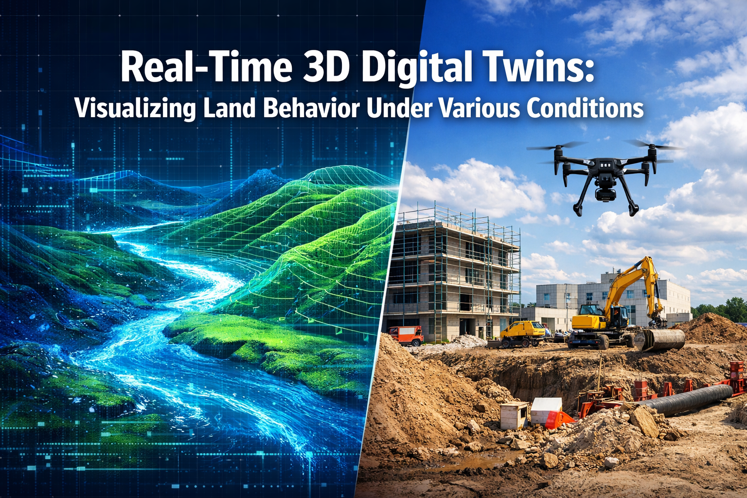
Imagine standing on an empty plot of land, yet seeing exactly how it will respond to torrential rain, prolonged drought, or the weight of a five-story building—all before a single shovel breaks ground. This isn't science fiction. In 2026, Real-Time 3D Digital Twins: Visualizing Land Behavior Under Various Conditions has transformed how developers, planners, and surveyors make critical decisions about property development and land management.
These high-fidelity, continuously-updating digital replicas create interactive virtual models that visualize land behavior under multiple conditions, including slope erosion projections, water flow simulations, vegetation pattern changes, and infrastructure stress testing—all within a single interactive platform.[1] The technology represents a fundamental shift from reactive problem-solving to proactive scenario planning, enabling stakeholders to test environmental scenarios before committing millions to construction projects.
Key Takeaways
✅ Real-Time 3D Digital Twins: Visualizing Land Behavior Under Various Conditions enables developers to simulate environmental scenarios like flooding, erosion, and structural stress before breaking ground, reducing costly mistakes and project delays.
✅ Multi-sensor autonomous drones now capture comprehensive site data in single flights, eliminating the need for multiple site visits and providing continuous updates to digital twin models throughout project lifecycles.[1]
✅ Operational outcomes have replaced visualization as the primary focus in 2026, with successful implementations prioritizing energy reduction, faster response times, and compliance evidence over immersive 3D graphics.[3]
✅ AI-readiness requires centralizing data, integrating systems, and cleaning asset structures before implementing advanced analytics—making 2026 a critical year for establishing proper foundations.[3]
✅ Industry adoption is strongest in higher education, healthcare, social housing, and large commercial real estate portfolios where operational complexity demands sophisticated monitoring and predictive capabilities.[3]
Understanding Real-Time 3D Digital Twins for Land Visualization
What Are Digital Twins in Land Management?
A digital twin is far more than a static 3D model or computer-aided design (CAD) rendering. It's a living, breathing virtual replica of physical land that updates continuously based on real-world sensor data, environmental conditions, and predictive algorithms. When applied to land behavior visualization, these systems integrate multiple data streams—topographic surveys, soil composition analysis, weather patterns, groundwater levels, and vegetation health—into a unified interactive model.
The "real-time" component distinguishes modern digital twins from traditional surveying methods. Rather than capturing a snapshot of conditions at a single moment, these systems maintain constant synchronization between physical reality and virtual representation. When rain falls on the actual property, sensors detect moisture levels, and the digital twin immediately updates to show water accumulation patterns, drainage effectiveness, and potential erosion risks.
For property professionals requiring comprehensive site documentation, understanding these capabilities complements traditional schedule of condition reports by adding predictive dimensions to baseline assessments.
Core Components of Land Behavior Digital Twins
Real-Time 3D Digital Twins: Visualizing Land Behavior Under Various Conditions relies on several integrated technologies working in concert:
| Component | Function | 2026 Capabilities |
|---|---|---|
| Multi-Sensor Drones | Data capture and continuous monitoring | Autonomous flight with predictive path planning; integrated LiDAR, thermal, multispectral sensors[1] |
| IoT Sensor Networks | Ground-based environmental monitoring | Soil moisture, structural stress, temperature, movement detection with edge computing |
| Predictive Modeling | Scenario simulation and forecasting | AI-powered weather impact, erosion progression, vegetation growth, structural load analysis |
| Spatial Computing Interfaces | Visualization and interaction | AR/VR integration with Apple Vision Pro and Meta Quest for immersive exploration[4] |
| Integration Platforms | Data normalization and system connectivity | Unified dashboards connecting BMS, CAFM, energy portals, and enterprise systems[3] |
The power emerges from integration rather than individual components. A drone survey provides valuable topographic data, but when combined with soil sensors, weather forecasting, and structural modeling, it becomes a comprehensive decision-support system.
How Land Behavior Visualization Differs from Traditional Surveying
Traditional land surveying captures "what is"—current elevations, boundaries, existing structures, and present conditions. Digital twin technology extends this to explore "what if" and "what will be."
Consider a sloped property near a waterway. A conventional chartered surveyor would document current topography, drainage patterns, and soil composition. A digital twin takes this foundation and adds:
🌧️ Rainfall simulation showing water flow patterns under various storm intensities
🏗️ Load testing demonstrating how proposed structures affect soil stability
🌱 Vegetation modeling predicting how landscaping changes affect erosion over time
📊 Temporal analysis forecasting seasonal variations in ground conditions
⚠️ Risk identification highlighting potential problems before they manifest physically
This predictive capability fundamentally changes the risk profile of development projects. Rather than discovering drainage problems after construction when remediation costs skyrocket, developers identify and address issues during the design phase when solutions remain affordable and flexible.[2]
The Technology Behind Real-Time 3D Digital Twins: Visualizing Land Behavior Under Various Conditions
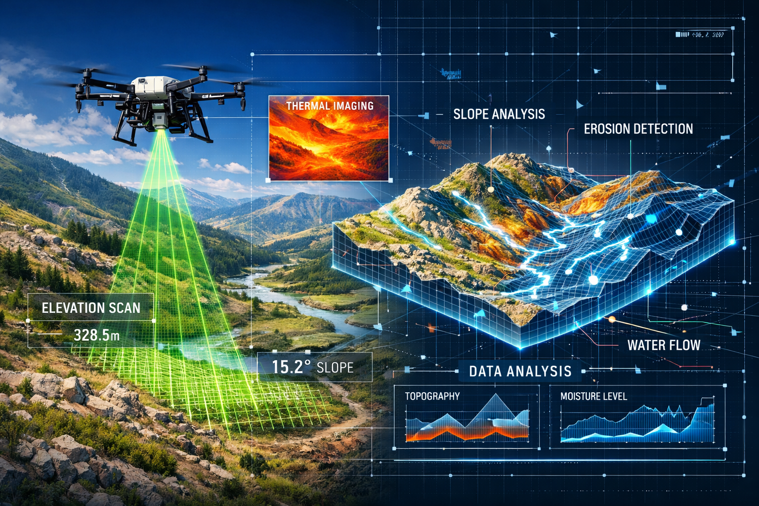
Autonomous Multi-Sensor Data Capture
The foundation of effective digital twins begins with comprehensive, accurate data collection. In 2026, autonomous multi-sensor drones have revolutionized this process, eliminating the need for multiple site visits that were standard practice just a decade ago.[1]
These advanced systems integrate several specialized sensors in a single platform:
LiDAR (Light Detection and Ranging) creates precise 3D point clouds of terrain, capturing elevations accurate to within centimeters even through vegetation cover. This technology excels at revealing subtle topographic variations that influence water flow and soil stability.
Thermal imaging detects temperature variations across the landscape, identifying moisture accumulation, underground water flow, heat retention patterns, and vegetation stress invisible to standard cameras.
Multispectral sensors analyze vegetation health through specific light wavelengths, measuring chlorophyll content, water stress, and growth patterns that indicate soil quality and drainage effectiveness.
High-resolution optical cameras provide contextual visual documentation, enabling stakeholders to correlate technical data with recognizable site features.
What makes 2026 systems truly revolutionary is their autonomous operation. Rather than requiring skilled pilots to manually program flight paths, emerging systems use predictive modeling to automatically adjust altitude, angle, and sensor selection to achieve optimal readings.[1] The drone "understands" what data it needs and adapts its behavior accordingly—flying lower over areas requiring detailed analysis, switching sensors based on lighting conditions, and even scheduling return visits when weather conditions optimize specific measurements.
For properties requiring specialized assessments, these capabilities complement traditional drone roof surveys by extending coverage to entire parcels rather than individual structures.
Continuous Data Integration and Normalization
Capturing data represents only the first challenge. The real complexity lies in integrating diverse data sources into coherent, actionable information.
A January 14, 2026 industry assessment revealed a sobering reality: despite technological advancement, most estates teams lack normalized asset data, consistent naming conventions, and integrated systems. Data remains fragmented across Building Management Systems (BMS), spreadsheets, Computerized Facility Management (CAFM) platforms, and energy portals.[3]
Successful digital twin implementations address this challenge through:
Unified data platforms that automatically ingest information from multiple sources, applying consistent formatting and naming conventions regardless of origin.
Ontology frameworks that establish relationships between different data types—connecting soil moisture readings to drainage system performance, linking vegetation health to irrigation effectiveness, and correlating structural sensors to load-bearing capacity.
Real-time validation algorithms that identify anomalous readings, flag sensor malfunctions, and request verification when measurements fall outside expected parameters.
Historical contextualization that compares current conditions against baseline measurements and seasonal patterns, distinguishing normal variations from genuine concerns.
This integration challenge explains why industry experts emphasize that successful deployments prioritize operational problems first, then design systems around existing processes—the opposite of technology-led approaches that create platforms before identifying user needs.[3]
Predictive Modeling and Scenario Simulation
The transformative power of Real-Time 3D Digital Twins: Visualizing Land Behavior Under Various Conditions emerges most clearly in predictive capabilities. Digital twins enable organizations to test operational changes and predict outcomes before physical implementation, reducing delays and costly rework.[4]
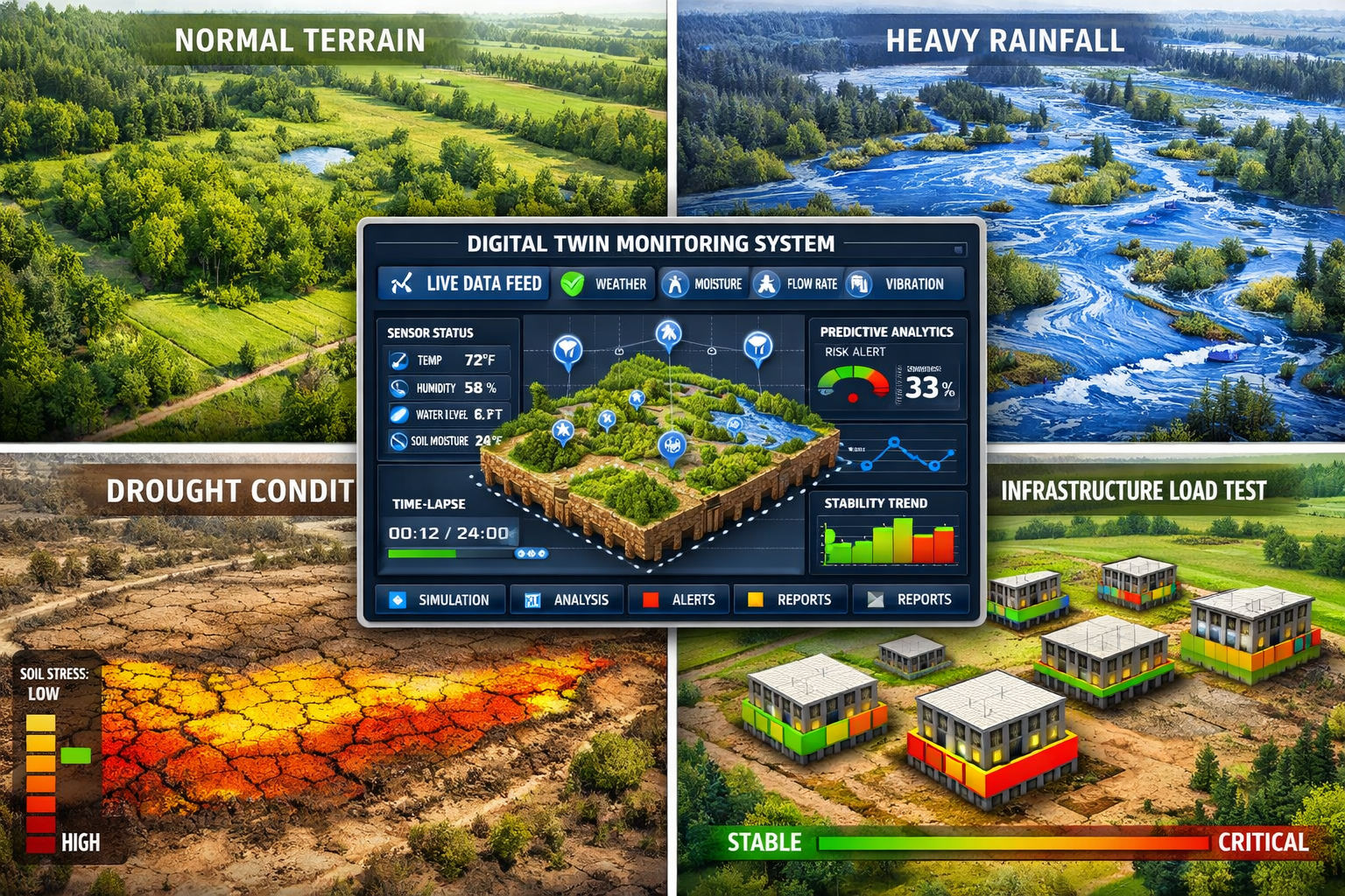
Environmental scenario modeling simulates how land responds to various conditions:
- Extreme weather events: 100-year flood simulations, drought impact analysis, heat wave effects on vegetation and soil
- Seasonal variations: Winter freeze-thaw cycles, spring runoff patterns, summer heat stress
- Climate change projections: Long-term shifts in precipitation, temperature extremes, and vegetation viability
Development impact analysis evaluates how proposed changes affect land behavior:
- Grading and excavation: Slope stability under various cut-and-fill scenarios, erosion potential from exposed soil
- Impervious surface addition: Stormwater runoff changes from buildings, parking areas, and hardscaping
- Vegetation removal or addition: Erosion control effectiveness, microclimate modifications, wildlife habitat impact
Infrastructure stress testing examines how structures interact with land conditions:
- Foundation loading: Soil bearing capacity under various building designs and occupancy scenarios
- Utility performance: Drainage system adequacy during peak flow events, irrigation system effectiveness during drought
- Access route durability: Road and pathway performance under heavy equipment, seasonal ground movement
For properties undergoing significant modifications, these capabilities inform party wall matters by predicting how excavation and construction activities might affect adjacent properties before work begins.
Applications of Real-Time 3D Digital Twins in Property Development and Land Management
Design Phase Optimization
During architectural and engineering design phases, digital twins enable simulation of various design scenarios to optimize layouts for functionality, aesthetics, and energy efficiency, while integrating environmental studies and zoning regulations into comprehensive compliant plans.[2]
Site layout optimization uses terrain behavior modeling to position buildings, roads, and utilities for maximum efficiency and minimum environmental impact. Rather than discovering that a planned building location experiences seasonal flooding or requires expensive soil stabilization, designers test multiple configurations virtually, identifying optimal placements before finalizing plans.
Grading and drainage design becomes an iterative process rather than a one-time calculation. Engineers simulate different grading schemes, observing how each affects water flow during various storm intensities. They test retention pond sizing, swale effectiveness, and drainage pipe capacity under extreme conditions, ensuring systems perform reliably when needed most.
Landscape integration considers how vegetation choices affect erosion control, water consumption, maintenance requirements, and aesthetic goals across seasons and years. Digital twins model plant growth over time, showing how initial plantings evolve and how mature landscapes perform their intended functions.
Regulatory compliance verification integrates zoning setbacks, environmental protection requirements, stormwater management regulations, and accessibility standards into the design process. Rather than discovering compliance issues during permit review, digital twins identify conflicts early when design modifications remain straightforward and inexpensive.
This comprehensive approach to design optimization reduces the likelihood of requiring specific defect reports later by addressing potential issues before they become physical problems.
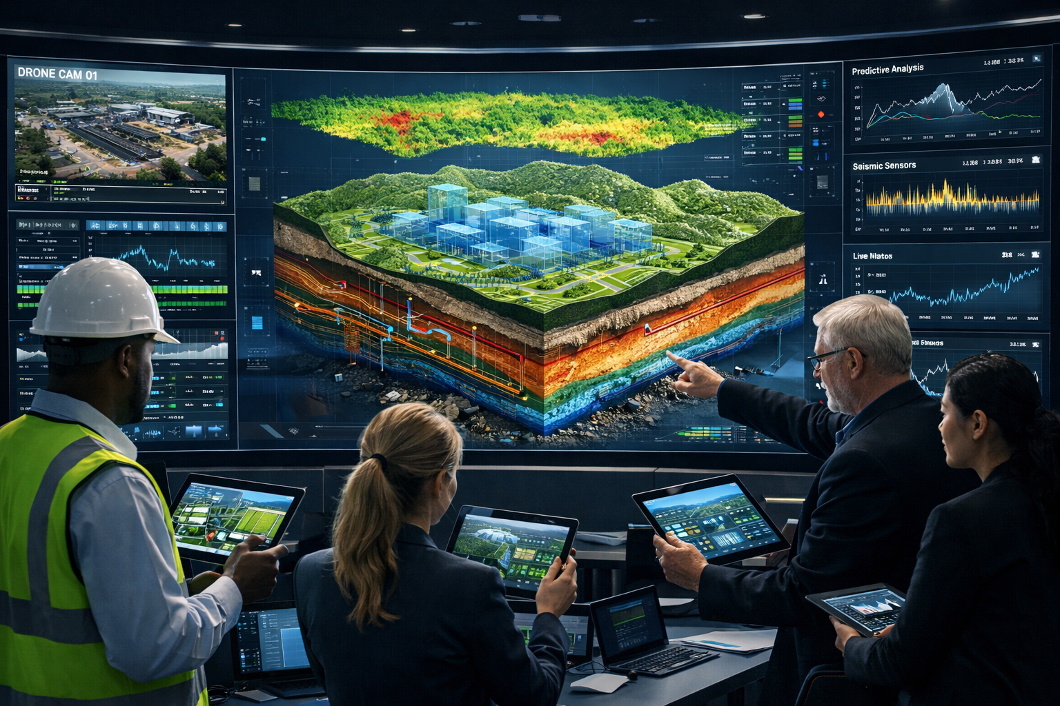
Construction Phase Monitoring and Coordination
Real-Time 3D Digital Twins: Visualizing Land Behavior Under Various Conditions transforms construction management by providing continuous comparison between physical construction and the digital model, enabling precise coordination, resource allocation, and safety management while identifying potential conflicts before they occur.[2]
Progress tracking uses drone surveys to document construction advancement, automatically comparing actual conditions against planned schedules. Delays become visible immediately, enabling proactive response rather than reactive problem-solving when deadlines approach.
Quality assurance verifies that grading, compaction, and drainage installation match design specifications. Rather than discovering inadequate soil compaction after building construction when remediation becomes prohibitively expensive, sensors and surveys confirm proper execution during each construction phase.
Safety management monitors excavation stability, temporary drainage effectiveness, and equipment operation in relation to soil conditions and weather impacts. Digital twins alert supervisors when ground conditions deteriorate to unsafe levels, preventing accidents before they occur.
Coordination optimization ensures that multiple contractors work efficiently without conflicts. When underground utility installation, foundation excavation, and site grading all proceed simultaneously, the digital twin maintains a current model showing each team's progress and identifying potential interference before crews encounter problems in the field.
For projects involving work near property boundaries, this coordination capability enhances party wall agreement compliance by documenting that construction activities remain within authorized limits and monitoring for any impacts on adjacent properties.
Operational Management and Maintenance
The value of digital twins extends far beyond design and construction into long-term operational management. In 2026, the industry is transitioning focus away from immersive 3D visualization toward measurable operational outcomes: energy reduction, reduced downtime, faster response times, and compliance evidence.[3]
Predictive maintenance monitors infrastructure performance, identifying developing problems before failures occur. Drainage systems show reduced flow capacity as sediment accumulates, triggering maintenance before blockages cause flooding. Retaining walls display subtle movement patterns indicating foundation issues, enabling repairs before catastrophic failure.
Performance optimization tracks how land and infrastructure systems perform under actual operating conditions compared to design assumptions. Irrigation systems adjust automatically based on soil moisture sensors and weather forecasts, reducing water consumption while maintaining landscape health. Stormwater systems demonstrate compliance with discharge permits through continuous monitoring rather than periodic manual sampling.
Asset lifecycle management maintains comprehensive records of all site components, their installation dates, maintenance history, and current condition. This documentation proves invaluable for property valuations, insurance assessments, and regulatory compliance verification.
Emergency response enables rapid, informed decision-making during crisis situations. When extreme weather threatens, facility managers see real-time predictions of flooding risk, drainage system capacity, and vulnerable areas requiring immediate attention. Response teams access current site conditions remotely, directing resources efficiently without requiring dangerous site visits during hazardous conditions.
Urban Planning and Infrastructure Development
At larger scales, Real-Time 3D Digital Twins: Visualizing Land Behavior Under Various Conditions supports comprehensive urban planning and regional infrastructure development. Cities and regions create digital twins encompassing entire watersheds, transportation networks, and development corridors.[6]
Comprehensive planning evaluates how proposed developments affect regional systems—stormwater management, transportation capacity, utility infrastructure, and environmental resources. Planners simulate growth scenarios, identifying infrastructure investments needed to support development while maintaining quality of life and environmental protection.
Climate resilience planning models how communities respond to climate change impacts—increased flooding frequency, heat island effects, drought conditions, and extreme weather events. Cities test adaptation strategies virtually, identifying cost-effective interventions that enhance resilience without requiring massive infrastructure replacement.
Multi-stakeholder coordination provides a common platform where government agencies, developers, utilities, and community organizations view consistent information and evaluate proposals using shared data. This transparency reduces conflicts and accelerates decision-making by ensuring all parties work from the same factual foundation.
Public engagement enables community members to visualize proposed changes and understand their impacts. Rather than reviewing abstract plans and technical documents, residents explore interactive models showing how developments affect views, traffic, green space, and neighborhood character.
Implementation Challenges and Best Practices for Real-Time 3D Digital Twins
Overcoming Data Integration Obstacles
The most significant barrier to successful digital twin implementation isn't technology—it's data management. Organizations must address several fundamental challenges:
Legacy system integration requires connecting older Building Management Systems, CAFM platforms, and specialized monitoring equipment that weren't designed for interoperability. Successful implementations use middleware platforms that translate between different data formats and communication protocols, creating unified data streams from disparate sources.
Naming convention standardization establishes consistent terminology across all systems. When one system calls a feature "Retention Pond A," another labels it "Stormwater Basin 1," and a third references "SW-RP-001," integration becomes impossible. Organizations must invest time in creating comprehensive asset registers with standardized naming that all systems adopt.
Data quality assurance implements validation processes that identify erroneous readings, sensor malfunctions, and data gaps. Automated quality checks flag suspicious values, request verification, and maintain data integrity essential for reliable decision-making.
Historical data migration transfers existing records into new systems, maintaining institutional knowledge while enabling advanced analytics. This process often reveals inconsistencies and gaps in historical records, requiring significant cleanup before migration proceeds.
For organizations managing multiple properties across regions, these challenges multiply. Chartered surveyors serving diverse locations must establish consistent standards across all sites while accommodating regional variations in regulations, climate conditions, and operational practices.
Prioritizing Operational Outcomes Over Technology Features
Industry experts consistently emphasize a critical success factor: define operational problems first, then design technology solutions—not the reverse.[3] Organizations that begin with "we need a digital twin" often create expensive systems that don't address actual business needs.
Successful implementations follow a different path:
1. Identify specific operational challenges: What problems currently cause delays, increase costs, or create risks? Examples include unexpected drainage failures, vegetation maintenance inefficiencies, or difficulty demonstrating regulatory compliance.
2. Quantify current performance: Establish baseline metrics for the problems identified. How frequently do failures occur? What do they cost? How much time do current processes require?
3. Define measurable improvement targets: Specify concrete goals like "reduce emergency drainage repairs by 40%" or "decrease irrigation water consumption by 25% while maintaining landscape health."
4. Design minimal viable systems: Implement only the sensors, models, and interfaces necessary to address identified problems and measure improvement. Resist the temptation to deploy comprehensive systems before proving value.
5. Validate results and expand: Demonstrate measurable improvements before expanding to additional applications. Build organizational confidence through proven success rather than promising future capabilities.
This pragmatic approach explains why higher education, healthcare, social housing, and large commercial real estate portfolios show the strongest operational adoption in 2026—these sectors face mission-critical operational challenges where digital twins deliver measurable value.[3]
Building AI-Ready Foundations
Industry leaders emphasize that 2026 must focus on making systems "AI-ready" by centralizing data, integrating systems, and cleaning asset structures before implementing AI-powered analytics—positioning AI as a practical decision-support tool rather than a marketing feature.[3]
Data centralization consolidates information from all sources into unified repositories where AI algorithms can access comprehensive datasets. Fragmented data across multiple systems prevents AI from identifying patterns and relationships that span different data types.
Consistent data structures establish standardized formats, units, and taxonomies that AI systems require for effective analysis. When soil moisture appears as percentages in one system, volumetric water content in another, and qualitative descriptions in a third, AI cannot correlate this information with other variables.
Temporal continuity maintains consistent measurement intervals and preserves historical records that AI uses to identify trends, seasonal patterns, and anomalies. Gaps in historical data limit AI's ability to distinguish normal variations from genuine problems.
Metadata richness documents the context surrounding each measurement—sensor location, calibration status, environmental conditions, and data quality indicators. AI algorithms use this metadata to weight information appropriately and avoid drawing conclusions from unreliable data.
Validation frameworks establish ground truth datasets that verify AI predictions against actual outcomes. Without validation, organizations cannot distinguish accurate AI insights from algorithmic artifacts.
Organizations investing in these foundations now position themselves to leverage AI capabilities as they mature, while those skipping directly to AI implementation often discover their data infrastructure cannot support effective analytics.
Selecting Appropriate Technology Partners
The digital twin ecosystem includes numerous technology providers, each offering different capabilities, integration approaches, and business models. Selecting appropriate partners requires careful evaluation:
Domain expertise in land management, property development, or facility operations ensures providers understand industry-specific challenges and regulatory requirements. Generic IoT platforms may offer impressive technology but lack understanding of surveying standards, environmental compliance, or construction coordination needs.
Integration capabilities determine how effectively new systems connect with existing infrastructure. Providers should demonstrate successful integrations with the specific BMS, CAFM, and enterprise systems the organization currently uses.
Scalability and flexibility enable systems to grow from initial pilot implementations to comprehensive deployments. Architectures that work for a single property may not scale to portfolios spanning multiple regions.
Support and training ensure that staff can effectively operate and maintain systems. Technology sophistication means little if users cannot access needed information or troubleshoot common problems.
Total cost of ownership includes not just initial implementation but ongoing subscription fees, maintenance costs, upgrade expenses, and internal staff time requirements. Some apparently affordable solutions carry hidden costs that emerge over time.
For organizations requiring comprehensive property services, partnering with established chartered surveyors who understand both traditional assessment methods and emerging digital twin technologies often provides the most effective implementation path.
Future Trends in Real-Time 3D Digital Twins: Visualizing Land Behavior Under Various Conditions
Spatial Computing and Immersive Interfaces
Advanced implementations increasingly integrate digital twin platforms with IoT sensors and enterprise systems using 3D, AR, VR, and mixed reality interfaces, including Apple Vision Pro and Meta Quest deployments, for immersive system exploration.[4]
Augmented reality field applications enable surveyors, inspectors, and maintenance personnel to view digital twin data overlaid on physical sites through mobile devices or AR glasses. Standing at a proposed building location, users see simulated water flow patterns, underground utilities, soil composition, and structural load impacts superimposed on the actual landscape.
Virtual reality planning sessions allow stakeholders to explore proposed developments at full scale before construction. Design teams walk through virtual buildings, experiencing spatial relationships, views, and circulation patterns while the digital twin simultaneously displays land behavior implications of each design choice.
Mixed reality collaboration connects remote participants in shared virtual environments where they manipulate digital twin models together, testing scenarios and evaluating options regardless of physical location. This capability proves especially valuable for projects involving stakeholders across multiple regions or international teams.
Gesture and voice interfaces enable natural interaction with complex data without requiring technical expertise. Facility managers ask questions like "show me areas at risk during a 50-year storm" and receive immediate visual responses rather than navigating through multiple menus and technical interfaces.
Integration with Building Information Modeling (BIM)
The convergence of digital twins with Building Information Modeling creates comprehensive systems spanning site conditions, building design, construction processes, and operational management. In 2026, AEC (Architecture, Engineering, Construction) technology increasingly treats BIM and digital twins as complementary components of unified platforms.[7]
Seamless design-to-operations workflows maintain continuous data flow from initial site analysis through design development, construction execution, and long-term facility management. Information captured during surveying automatically populates design models, construction schedules reference real-time site conditions, and as-built documentation feeds directly into operational digital twins.
Integrated simulation environments combine building performance modeling with land behavior analysis. Energy simulations account for actual microclimate conditions from the site digital twin. Structural analysis incorporates real soil properties and foundation performance data. Stormwater management design integrates building runoff with site drainage systems.
Lifecycle data continuity preserves information throughout project lifecycles, eliminating the data loss that traditionally occurs at handoffs between design, construction, and operations phases. Decisions made during design remain documented and accessible decades later when renovations or expansions require understanding original assumptions.
Predictive Analytics and Machine Learning Evolution
As digital twins accumulate operational data, machine learning algorithms identify patterns and relationships invisible to human analysis, enabling increasingly sophisticated predictions:
Failure prediction analyzes subtle performance changes that precede equipment failures or infrastructure problems. Rather than waiting for obvious symptoms, AI identifies early indicators enabling proactive intervention before failures occur.
Optimization recommendations suggest operational adjustments that improve performance based on actual results rather than theoretical models. Irrigation schedules adapt to specific site conditions and vegetation response. Drainage system maintenance timing optimizes based on actual sediment accumulation rates rather than arbitrary intervals.
Anomaly detection flags unusual conditions requiring investigation. When sensor readings deviate from expected patterns, AI determines whether variations reflect genuine problems or normal responses to environmental changes, reducing false alarms while catching real issues early.
Scenario generation automatically creates and evaluates multiple options for addressing identified challenges. When a drainage problem emerges, AI generates potential solutions, simulates their effectiveness, and presents ranked recommendations with cost-benefit analysis.
Regulatory Integration and Compliance Automation
Digital twins increasingly connect directly with regulatory systems, automating compliance documentation and enabling real-time verification:
Automated reporting generates required regulatory submissions directly from digital twin data, eliminating manual data collection and report preparation. Stormwater discharge monitoring, environmental impact documentation, and safety compliance records populate automatically from continuous monitoring.
Real-time compliance verification alerts operators immediately when conditions approach regulatory limits, enabling corrective action before violations occur. Rather than discovering exceedances during periodic sampling, organizations maintain continuous compliance awareness.
Permit condition tracking monitors adherence to development approvals, construction permits, and operational authorizations. Digital twins document that activities remain within authorized parameters, providing evidence for inspectors and regulators.
Predictive compliance management forecasts future compliance status based on current trends and planned activities. Organizations identify potential future violations early enough to implement preventive measures rather than reactive corrections.
Conclusion: Transforming Decision-Making Through Virtual Land Behavior Visualization
Real-Time 3D Digital Twins: Visualizing Land Behavior Under Various Conditions represents far more than technological innovation—it fundamentally transforms how property professionals, developers, and planners approach decision-making. By enabling comprehensive scenario simulation before physical implementation, these systems shift the industry from reactive problem-solving to proactive risk management.
The technology has matured beyond experimental applications to deliver measurable operational value in 2026. Organizations implementing digital twins report reduced emergency repairs, lower resource consumption, faster project delivery, and improved regulatory compliance. Success requires focusing on operational outcomes rather than technological capabilities, investing in data infrastructure before advanced analytics, and selecting implementation partners with genuine domain expertise.
Actionable Next Steps for Property Professionals
For developers and planners considering digital twin adoption:
- Identify specific operational challenges where predictive capabilities would deliver measurable value—don't implement technology searching for problems to solve
- Assess current data infrastructure to understand integration requirements and data quality improvements needed before deployment
- Start with pilot implementations on single properties or specific applications, validating results before expanding to comprehensive systems
- Establish measurable success criteria defining concrete improvements expected from digital twin implementation
- Engage experienced partners who understand both traditional surveying standards and emerging digital technologies
For facility managers operating existing properties:
- Audit existing monitoring systems to identify data already being collected but not effectively utilized
- Document recurring operational problems that consume resources or create risks, quantifying their current impact
- Evaluate integration opportunities connecting fragmented systems into unified platforms that enable comprehensive analysis
- Prioritize AI-readiness by centralizing data, standardizing naming conventions, and cleaning asset structures
- Develop staff capabilities through training on data-driven decision-making and digital tool utilization
For surveyors and consultants serving clients:
- Expand service offerings to include digital twin consultation, implementation support, and ongoing data validation
- Develop partnerships with technology providers offering complementary capabilities
- Invest in training on emerging technologies while maintaining traditional surveying expertise
- Communicate value propositions clearly, emphasizing operational outcomes rather than technical features
- Maintain professional standards ensuring digital twin implementations meet the same quality and accuracy requirements as traditional surveying
The convergence of autonomous data capture, real-time integration, predictive modeling, and immersive visualization creates unprecedented capabilities for understanding and managing land behavior. Organizations that embrace these tools thoughtfully—prioritizing operational value, investing in proper foundations, and maintaining focus on measurable outcomes—position themselves to deliver superior results while managing risks more effectively than ever before possible.
As the technology continues evolving, the competitive advantage will belong not to those with the most sophisticated systems, but to those who most effectively translate digital capabilities into operational excellence and informed decision-making. The future of property development and land management lies not in replacing human expertise with technology, but in augmenting professional judgment with comprehensive, real-time insights that enable better choices before commitments become irreversible.
For organizations ready to explore how Real-Time 3D Digital Twins: Visualizing Land Behavior Under Various Conditions can enhance their specific operations, consulting with experienced professional surveyors who understand both traditional assessment methods and emerging digital capabilities provides the most effective starting point for successful implementation.
References
[1] Future Land Surveying 2026 – https://haller-blanchard.com/future-land-surveying-2026/
[2] Design Construction – https://www.nemetschek-dtwin.com/design-construction
[3] What Do Digital Twins Hold For 2026 From Visualisation To Smart Building Operations – https://www.twinview.com/insights/what-do-digital-twins-hold-for-2026-from-visualisation-to-smart-building-operations
[4] Top Digital Twin Development Companies – https://treeview.studio/blog/top-digital-twin-development-companies
[5] Real Time 3d Digital Twins For Property Development Interactive Models That Update Live – https://nottinghillsurveyors.com/blog/real-time-3d-digital-twins-for-property-development-interactive-models-that-update-live
[6] Digital Twin Urban Planning – https://www.toobler.com/blog/digital-twin-urban-planning
[7] The 2026 Aec Technology Bim Ai Digital Twins – https://www.teslaoutsourcingservices.com/blog/the-2026-aec-technology-bim-ai-digital-twins/