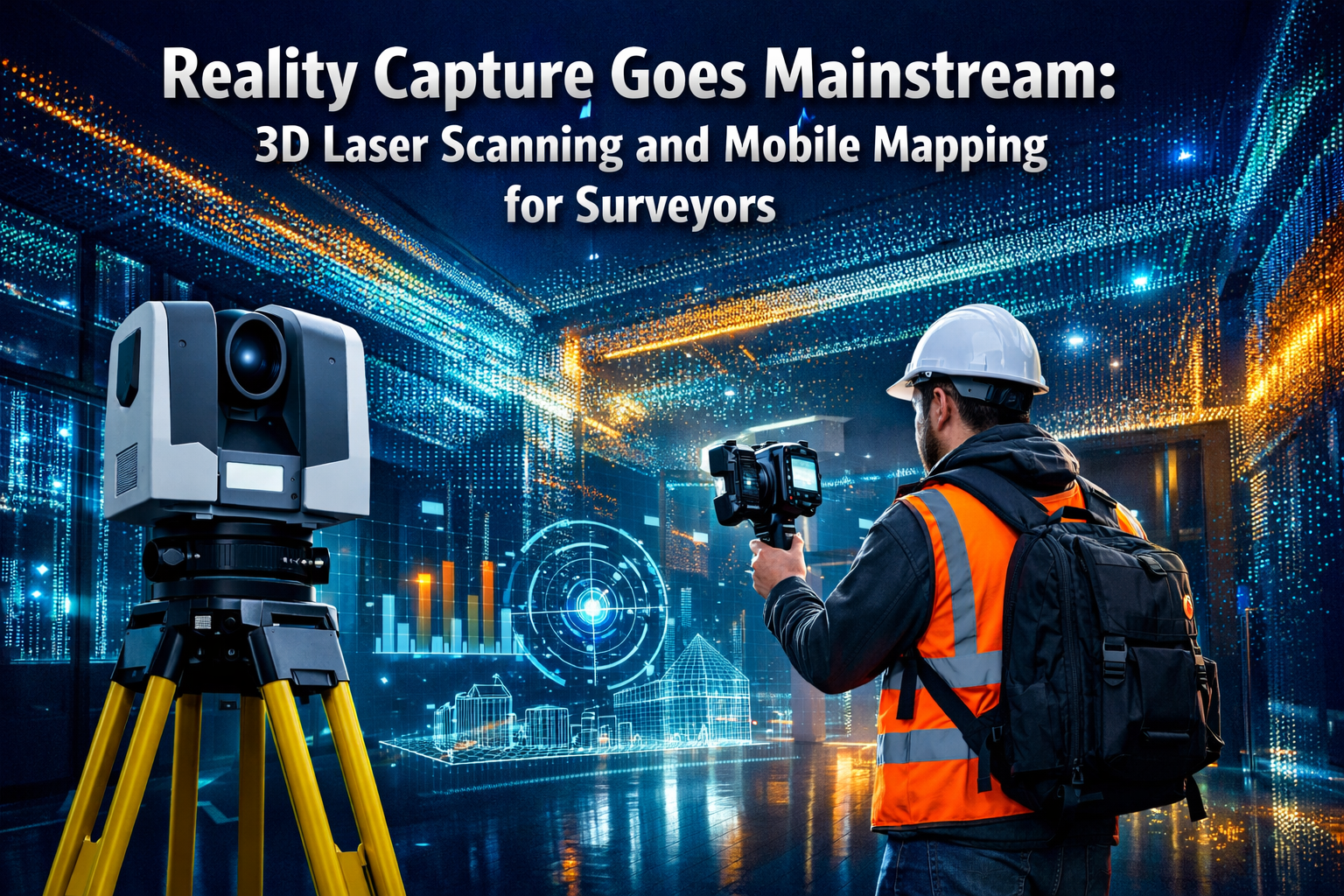
The surveying profession stands at a transformative crossroads in 2026. Reality capture technologies—once reserved for high-budget projects and specialized applications—have now become essential tools in the everyday toolkit of professional surveyors. The conversation around Reality Capture Goes Mainstream: 3D Laser Scanning and Mobile Mapping for Surveyors reflects a fundamental shift: these technologies are no longer experimental innovations but operational necessities that define competitive advantage, project timelines, and client expectations.
For chartered surveyors across London and beyond, the integration of 3D laser scanning and mobile mapping represents both opportunity and challenge. This comprehensive guide breaks down the accessible tools, practical workflows, and adoption strategies that surveyors need to navigate the accelerating digital transformation reshaping the profession in 2026.
Key Takeaways
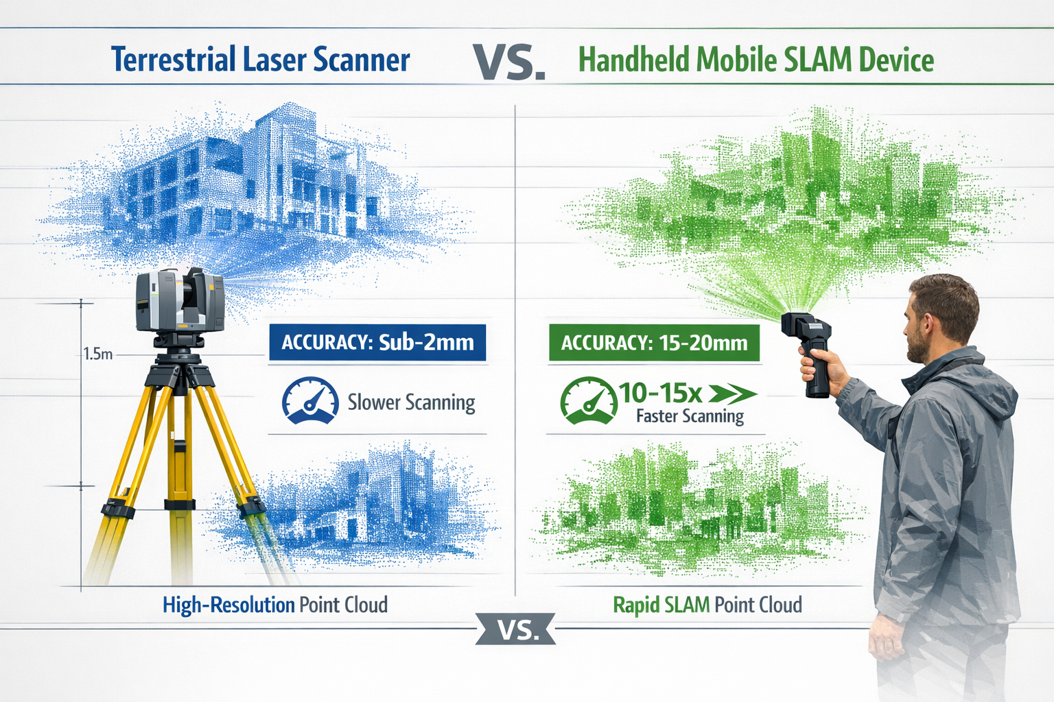
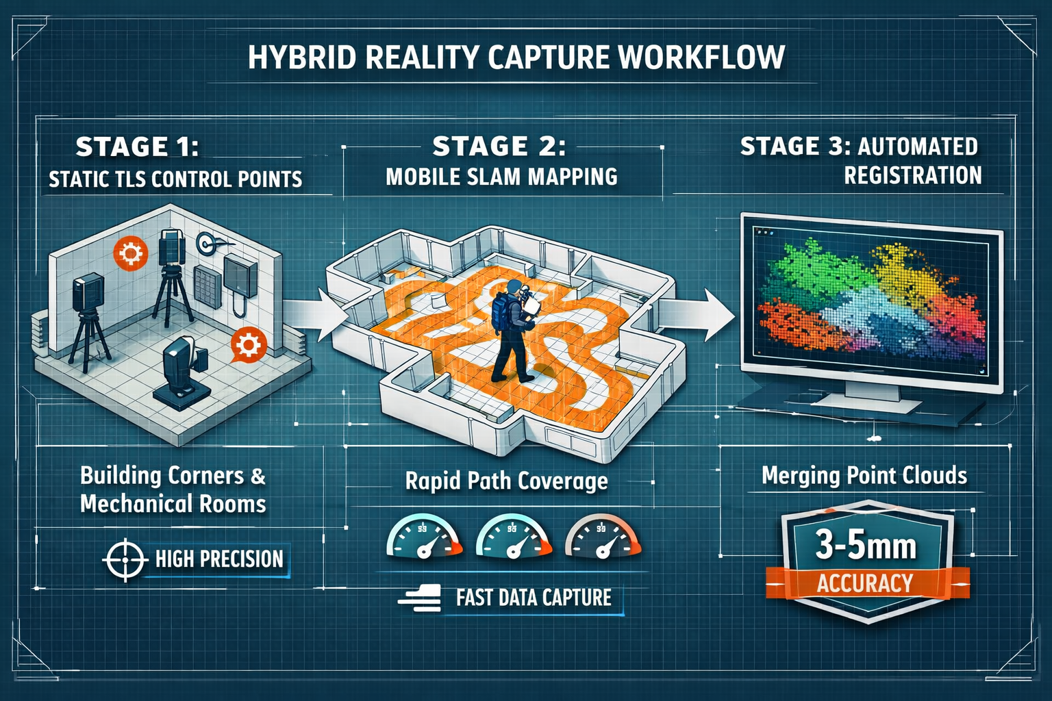
- Hybrid workflows combining terrestrial laser scanning (TLS) and mobile SLAM are now the industry standard, achieving 3-5mm accuracy while maintaining operational speed advantages of 10-15 times faster than traditional methods[1]
- Mobile scanning reduces field costs by 50-70% and compresses project timelines from weeks to days, though downstream modeling costs increase approximately 20%[3]
- Real-time quality feedback systems in 2026 mobile scanners provide live confidence maps, enabling operators to adjust capture strategies on-site and prevent costly data gaps[1]
- AI-powered automation in registration software eliminates manual alignment, automatically snapping mobile trajectories to static control points for survey-grade accuracy[1]
- Strategic deployment patterns focus static TLS on high-value control points (mechanical rooms, building perimeters, elevator cores) while mobile SLAM handles rapid volumetric infill[1][3]
Understanding Reality Capture: The Foundation of Modern Surveying
What Is Reality Capture?
Reality capture refers to the process of digitally documenting physical spaces, structures, and environments to create accurate three-dimensional representations. Unlike traditional surveying methods that collect discrete measurements at specific points, reality capture technologies gather millions or billions of data points to create comprehensive point clouds—dense collections of coordinates that represent every visible surface.
This fundamental shift from selective measurement to comprehensive documentation has profound implications:
- Complete spatial records that can be revisited digitally without return site visits
- Millimeter-level accuracy for engineering and construction applications
- Visual context through integrated photography and panoramic imagery
- Collaborative platforms that enable remote stakeholders to virtually "walk through" sites
The Two Pillars: Terrestrial Laser Scanning and Mobile Mapping
The reality capture ecosystem in 2026 rests on two complementary technologies:
Terrestrial Laser Scanning (TLS) employs stationary instruments mounted on tripods that systematically rotate and emit laser pulses. These devices measure the time-of-flight for each laser return to calculate precise distances, building point clouds with sub-2mm accuracy (typically 1.9mm for survey-grade instruments)[1]. Leading manufacturers include Leica, Trimble, and FARO, whose flagship models can capture millions of points per second from a single station.
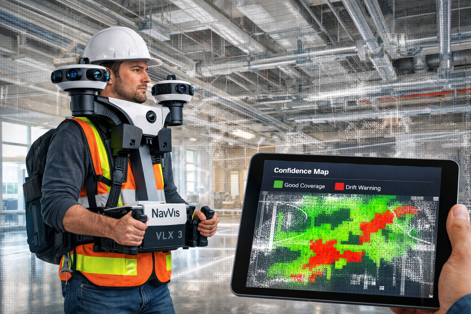
Mobile Mapping Systems utilize SLAM technology (Simultaneous Localization and Mapping) integrated into handheld or backpack-mounted devices. These systems combine multiple LiDAR sensors with inertial measurement units (IMUs) and visual cameras to create point clouds while the operator walks through spaces. Modern devices like the NavVis VLX 3 and Emesent Hovermap ST-X feature dual or quad LiDAR sensors with panoramic camera arrays[1].
The critical distinction: static scanning prioritizes precision, while mobile mapping prioritizes speed and coverage.
Reality Capture Goes Mainstream: The 2026 Technology Landscape
The End of the Static vs. Mobile Debate
The surveying industry has moved beyond treating terrestrial laser scanning and mobile mapping as competing alternatives. The question is no longer "which technology should we choose?" but rather "how do we integrate both effectively?"
Leading surveying and engineering firms have standardized what industry experts call the "precision backbone" approach[1]. This methodology combines:
✅ Terrestrial laser scanning for geometric control networks
✅ Mobile SLAM for rapid volumetric infill
✅ Automated registration software to merge datasets seamlessly
This represents a fundamental operational shift from competing technologies to integrated capture strategies that leverage the strengths of each approach while mitigating their respective limitations.
Accuracy Specifications That Matter in 2026
Understanding accuracy requirements is essential for appropriate technology deployment:
| Technology | Typical Accuracy | Optimal Applications |
|---|---|---|
| Static TLS | Sub-2mm (1.9mm survey-grade) | Control points, mechanical rooms, building perimeters, floor flatness (FF/FL) |
| Mobile SLAM | 15-20mm (real-world with drift) | Volumetric coverage, corridors, large open spaces |
| Optimized Hybrid | 3-5mm (combined workflow) | Most AEC and facility management applications |
The 3-5mm accuracy achieved through hybrid workflows[1][3] represents the practical sweet spot for the majority of professional surveying applications in 2026. This precision level satisfies requirements for:
- Building Information Modeling (BIM) as-built documentation
- Clash detection in renovation projects
- Facility management spatial databases
- BOMA rentable area calculations (which require under 1 inch/~25mm accuracy)[3]
- Structural survey documentation
Speed Advantages Quantified
The operational velocity of mobile scanning has been thoroughly documented in 2026 deployments. Mobile SLAM devices consistently achieve 10-15 times faster coverage rates than static scanning for general volumetric documentation[1].
Real-world project timelines illustrate this advantage:
📊 500,000 sq. ft. commercial buildings: On-site surveying now takes "a few days" versus weeks with traditional methods[3]
📊 Complex industrial facilities: Projects completed in half a day that previously required multi-week timelines[4]
📊 Multi-floor office documentation: Single-operator mobile capture in 2-3 days versus 1-2 weeks for comprehensive static scanning
This speed advantage directly translates to reduced labor costs, minimized site disruption, and faster project delivery—critical factors for chartered surveyors competing in time-sensitive markets.
The Economics of Reality Capture: Cost-Benefit Analysis for 2026
Field Deployment Cost Reductions
Mobile capture technologies deliver substantial field cost advantages: 50-70% cheaper than comprehensive static scanning[3]. This reduction stems from:
- Reduced personnel requirements (single operator vs. multi-person crews)
- Compressed site time (fewer billable hours)
- Lower equipment mobilization costs (portable vs. multiple tripod setups)
- Minimal site access disruption (rapid walk-through vs. extended occupation)
For surveying practices serving North London or Central London commercial properties, these time savings translate directly to competitive advantages in proposal pricing and project scheduling.
Downstream Processing Considerations
The field cost advantage is partially offset by approximately 20% higher costs in downstream Scan-to-BIM modeling due to increased data noisiness in mobile captures[3]. Mobile point clouds require:
- More intensive filtering and cleaning
- Additional quality control steps
- More sophisticated registration algorithms
- Greater modeling time for extracting architectural features
However, the overall project economics remain favorable because:
✅ Fewer field trips reduce total project costs
✅ Reduced manpower requirements lower overhead
✅ High-accuracy data minimizes costly rework
✅ Comprehensive coverage prevents expensive return visits[2]
Return on Investment Timeline
For surveying practices considering reality capture adoption, the ROI calculation in 2026 typically shows:
- Initial equipment investment: £30,000-£150,000 depending on technology tier
- Break-even timeline: 8-18 months for practices with consistent project flow
- Competitive necessity: Increasingly required for commercial and industrial projects
The investment threshold has become more accessible as equipment costs have stabilized and software subscriptions have replaced prohibitive perpetual licenses.
Flagship Technologies: What Surveyors Are Deploying in 2026
Leading Mobile Scanning Platforms
The mobile scanning market has consolidated around several flagship platforms that define the state-of-the-art in 2026:
NavVis VLX 3 🎯
- Dual LiDAR sensors with panoramic camera arrays
- Captures millions of points per second
- Integrated real-time quality feedback
- Optimized for indoor commercial and industrial environments
- Industry-leading noise reduction algorithms[1]
Emesent Hovermap ST-X 🚁
- Quad LiDAR configuration for maximum coverage
- Autonomous drone-compatible for inaccessible areas
- Exceptional performance in GPS-denied environments
- Preferred for mining, tunnels, and complex infrastructure[1]
These devices represent the maturation of mobile SLAM technology, with significantly reduced noise and cleaner definition of sharp architectural features including door frames, pipes, and MEP systems[1].
Static Terrestrial Laser Scanner Standards
The terrestrial laser scanning market remains dominated by three manufacturers whose instruments define survey-grade precision:
Leica RTC360 and BLK Series
- Sub-millimeter accuracy with automated leveling
- Rapid scan times (under 2 minutes per station)
- Integrated visual documentation
- Industry standard for control networks
Trimble X12 and X7
- Automated target recognition
- Seamless integration with total station workflows
- Preferred for boundary and cadastral applications
FARO Focus Premium
- Exceptional range (up to 350m)
- High-density capture for forensic and heritage documentation
- Robust environmental performance
These instruments establish the geometric control framework that mobile systems reference, maintaining the precision foundation of hybrid workflows.
Software Ecosystem Integration
Reality capture hardware is only as effective as the software ecosystem that processes, registers, and delivers data. The 2026 landscape features:
Registration and Processing
- Automated algorithms that detect rigid TLS scans and snap mobile trajectories[1]
- Cloud-based processing for large datasets
- AI-powered feature extraction
Scan-to-BIM Platforms
- Direct point cloud to Revit/ArchiCAD workflows
- Automated floor plan generation
- Clash detection integration
Collaboration and Delivery
- Web-based point cloud viewers for stakeholder access
- Mobile apps for on-site reference
- Integration with project management platforms
This software maturation has been critical to making hybrid workflows operationally feasible at scale, reducing the technical expertise barrier that previously limited adoption.
Hybrid Workflow Implementation: Practical Strategies for Surveyors
The Precision Backbone Methodology
The precision backbone approach that has become standard practice in 2026 follows a systematic deployment pattern[1]:
Phase 1: Strategic Static Scanning 🎯
Deploy terrestrial laser scanners at carefully selected control points:
- Building perimeters and corners
- Mechanical rooms and equipment spaces
- Stairwells and elevator cores
- Floor flatness verification zones (FF/FL metrics)
- Survey control monuments
These static scans establish the geometric truth that constrains the entire capture.
Phase 2: Mobile Volumetric Infill 🚶
Conduct rapid mobile scanning to capture comprehensive coverage:
- Corridors and circulation spaces
- Office areas and open floor plans
- Exterior facades and site features
- Parking structures and loading areas
The mobile operator follows systematic patterns to ensure complete coverage while the device's real-time feedback system monitors data quality.
Phase 3: Automated Registration 💻
Modern registration software automatically:
- Detects rigid static TLS scans
- Identifies common features between static and mobile datasets
- Algorithmically constrains mobile drift
- Pulls mobile point clouds into alignment with survey-grade control[1]
This three-phase approach delivers 3-5mm accuracy while maintaining the 10-15x speed advantage of mobile capture[1].
Real-Time Quality Feedback Innovation
One of the most significant advances in 2026 mobile scanning technology is the integration of live operator feedback systems[1]. These systems display real-time "confidence maps" that:
✅ Alert operators to feature-poor environments (long, smooth tunnels, blank walls)
✅ Indicate areas where drift is likely accumulating
✅ Prompt loop closure maneuvers to reset accumulated error
✅ Suggest speed adjustments for optimal data quality
This represents a maturity shift from post-processing corrections to in-the-field adaptive capture. Operators can now verify data completeness and quality during collection, preventing costly return visits for gap filling.
For surveyors conducting drone roof surveys or complex facility documentation, this real-time validation capability significantly reduces project risk.
Deployment Patterns for Common Applications
Different surveying applications benefit from tailored hybrid deployment strategies:
Commercial Real Estate Documentation 🏢
- Mobile SLAM for rentable area (BOMA compliance at ~20mm accuracy)[3]
- Static TLS for property line verification and structural control
- Integrated panoramic imagery for marketing and tenant coordination
Industrial Facility As-Builts 🏭
- Dense static scanning in mechanical rooms and process areas
- Mobile scanning for general circulation and storage zones
- Specialized scanning for piping and equipment clearances
Heritage and Conservation Projects 🏛️
- Comprehensive static scanning for archival documentation
- Mobile scanning for accessibility and visitor circulation analysis
- High-resolution texture capture for restoration planning
Infrastructure and Civil Works 🌉
- Static control networks for survey-grade horizontal and vertical control
- Mobile corridor mapping for roadways and rail lines
- Drone-based photogrammetry for site context and topography
Organizational Adoption: Navigating the Digital Transformation
The Consolidation Trend in Surveying Practices
The surveying industry is experiencing significant organizational consolidation in 2026. Smaller surveying firms are growing into mid-sized companies that are subsequently being absorbed into larger geospatial organizations with integrated engineering, surveying, and environmental services departments[4].
This consolidation is driven by:
- Technology investment requirements that favor larger practices
- Multidisciplinary project demands requiring diverse expertise
- Client preferences for single-source providers
- Cloud platform adoption enabling distributed collaboration
For independent chartered surveyors in Kingston, Richmond, or Berkshire, this trend creates strategic choices about technology partnerships, outsourcing arrangements, or merger opportunities.
Building Internal Capability vs. Outsourcing
Surveying practices face a fundamental decision: develop internal reality capture capabilities or partner with specialized providers. The 2026 assessment framework considers:
Build Internal Capability When:
✅ Project volume justifies equipment utilization (typically 15+ projects annually)
✅ Practice has technical staff capable of training and specialization
✅ Client base values integrated service delivery
✅ Competitive differentiation requires proprietary workflows
Partner/Outsource When:
✅ Project volume is sporadic or seasonal
✅ Capital investment creates cash flow constraints
✅ Technical expertise development timeline is prohibitive
✅ Specialized applications (heritage, forensic) require niche equipment
Many successful practices adopt a hybrid approach: maintaining basic mobile scanning capability for routine documentation while outsourcing complex static scanning or specialized applications.
Training and Skill Development
The human capital challenge in reality capture adoption cannot be understated. Effective 2026 deployment requires:
Technical Skills 🎓
- Equipment operation and calibration
- Scan planning and quality control
- Point cloud processing and registration
- Software proficiency across multiple platforms
Project Management Skills 📋
- Hybrid workflow planning
- Client expectation management
- Deliverable specification and quality assurance
- Integration with traditional surveying outputs
Continuous Learning 📚
- Technology updates and new equipment releases
- Software capability enhancements
- Industry best practice evolution
- Regulatory and standards compliance
Leading surveying practices invest 5-10% of technical staff time in ongoing training and professional development to maintain competitive capability.
Application-Specific Deployment: Reality Capture Across Surveying Disciplines
Building Surveys and Structural Documentation
Reality capture has fundamentally transformed how surveyors conduct structural surveys and building documentation. The comprehensive spatial records enable:
As-Built Documentation 📐
- Complete building geometry for renovation planning
- MEP system routing and clearance verification
- Structural member sizing and condition assessment
- Foundation and settlement monitoring baselines
Defect Identification 🔍
- Floor flatness and levelness analysis
- Wall plumbness and alignment verification
- Ceiling and roof deflection measurement
- Crack mapping and deformation tracking
The ability to create virtual site access allows structural engineers, architects, and contractors to conduct detailed assessments without repeated site visits, particularly valuable for occupied buildings where access disruption must be minimized.
Boundary and Property Surveys
While reality capture excels at building documentation, its application to traditional boundary surveying requires careful consideration. The technology provides:
Property Line Verification 📏
- Fence and wall position documentation
- Encroachment identification
- Building setback compliance verification
- Easement and right-of-way mapping
However, legal boundary determination still requires traditional surveying methods with monumentation and certified control. Reality capture supplements rather than replaces cadastral surveying for boundary dispute resolution.
Party Wall and Dilapidation Surveys
Reality capture provides exceptional value for party wall documentation and schedule of dilapidations work:
Pre-Construction Condition Recording 📸
- Comprehensive baseline documentation of adjacent properties
- Crack and defect mapping with millimeter precision
- Photographic and geometric evidence for dispute resolution
- Repeatable measurements for settlement monitoring
Post-Construction Verification ✅
- Change detection through point cloud comparison
- Quantifiable damage assessment
- Evidence-based negotiation support
- Professional documentation for legal proceedings
The permanent digital record provides indisputable evidence that protects both building owners and surveyors from spurious claims.
Commercial and Industrial Facility Management
The facility management sector has become a primary driver of reality capture adoption in 2026. Applications include:
Space Planning and Utilization 🏢
- Rentable area calculation (BOMA standards compliance)[3]
- Tenant improvement planning
- Furniture and equipment layout optimization
- Accessibility compliance verification
Asset Management 🔧
- Equipment inventory and location tracking
- Maintenance access planning
- Replacement and upgrade feasibility studies
- Energy efficiency retrofit planning
Emergency Preparedness 🚨
- Evacuation route planning and verification
- Fire safety equipment placement optimization
- First responder familiarization and training
- Critical infrastructure redundancy planning
Regulatory Compliance and Professional Standards
RICS Guidelines and Best Practices
The Royal Institution of Chartered Surveyors (RICS) has established comprehensive guidance for reality capture deployment in professional surveying practice. The 2026 standards emphasize:
Accuracy Specification and Verification ✅
- Clear documentation of equipment calibration
- Appropriate accuracy levels for intended use
- Independent verification of critical measurements
- Transparent uncertainty quantification
Professional Competence 🎓
- Demonstrated training and experience requirements
- Continuing professional development obligations
- Appropriate insurance coverage for technology-enabled services
- Client communication regarding methodology and limitations
Surveyors must ensure their reality capture workflows align with RICS professional standards, particularly when deliverables inform valuation reports or legal proceedings.
Data Management and Client Confidentiality
The comprehensive nature of reality capture data creates significant data management responsibilities:
Storage and Retention 💾
- Point cloud datasets ranging from gigabytes to terabytes
- Long-term archival for professional liability protection
- Cloud vs. local storage security considerations
- Client data ownership and access rights
Confidentiality and Security 🔒
- Protection of sensitive facility information
- Secure transmission and sharing protocols
- Third-party processor agreements
- GDPR compliance for imagery containing identifiable individuals
Professional practices must implement robust data governance frameworks that protect client interests while enabling efficient project delivery.
Quality Assurance Protocols
Maintaining professional standards requires systematic quality assurance throughout the reality capture workflow:
Pre-Capture Planning 📋
- Site reconnaissance and access coordination
- Scan density and coverage specifications
- Control network design and monumentation
- Weather and environmental condition assessment
Field Quality Control ✅
- Real-time data verification using confidence maps[1]
- Redundant coverage in critical areas
- On-site registration verification
- Photographic documentation of conditions
Post-Processing Validation 🔍
- Registration accuracy assessment
- Point cloud density verification
- Feature extraction accuracy checking
- Deliverable completeness review
Future Trajectories: What's Next for Reality Capture in Surveying
AI and Machine Learning Integration
Artificial intelligence is rapidly transforming reality capture workflows beyond basic automation. The 2026 landscape features:
Automated Feature Extraction 🤖
- AI-powered recognition of doors, windows, and architectural elements
- Automated pipe and conduit routing extraction
- Intelligent classification of building components
- Machine learning-based defect detection
Predictive Quality Assessment 📊
- AI analysis of scan coverage completeness
- Automated identification of data gaps requiring additional capture
- Intelligent scan planning optimization
- Real-time capture quality prediction[5]
Natural Language Interfaces 💬
- Voice-commanded measurement queries
- Conversational AI for point cloud interrogation
- Automated report generation from spatial data
- Client-facing chatbots for deliverable access
These AI capabilities are reducing the technical expertise barrier that has historically limited reality capture adoption, making the technology accessible to a broader range of surveying professionals.
Integration with Digital Twins and BIM
The convergence of reality capture with Building Information Modeling (BIM) and digital twin platforms represents a fundamental shift from static documentation to dynamic facility management:
Living Building Models 🏗️
- Continuous updating of BIM models with periodic reality capture
- As-built verification throughout construction phases
- Post-occupancy monitoring and change detection
- Lifecycle asset management integration
Predictive Maintenance 🔧
- Condition assessment trending over time
- Equipment performance correlation with spatial data
- Proactive replacement planning
- Energy efficiency optimization
For chartered surveyors serving commercial and institutional clients, reality capture is evolving from project-based service to ongoing facility intelligence platform.
Democratization Through Technology Accessibility
The trajectory toward mainstream adoption continues with technology democratization:
Smartphone-Based Capture 📱
- LiDAR-equipped consumer devices (iPhone Pro, iPad Pro)
- Photogrammetry apps for basic documentation
- Cloud processing of mobile-captured data
- Acceptable accuracy for preliminary assessments
Subscription and Service Models 💳
- Equipment rental replacing capital purchase
- Software-as-a-Service (SaaS) eliminating perpetual licenses
- Processing-as-a-Service for practices without internal capability
- Training and certification programs accessible to sole practitioners
Standardized Deliverables 📄
- Industry-standard file formats (E57, LAS, RCP)
- Template-based reporting frameworks
- Automated quality compliance checking
- Client-friendly visualization platforms
These accessibility improvements are enabling smaller surveying practices to compete effectively with larger firms in technology-enabled service delivery.
Practical Implementation Guide: Getting Started with Reality Capture in 2026
Assessment Framework for Surveying Practices
Practices considering reality capture adoption should conduct systematic assessment:
Step 1: Project Portfolio Analysis 📊
- Identify projects that would benefit from 3D documentation
- Quantify potential time savings and cost reductions
- Assess client demand and competitive requirements
- Calculate annual project volume to justify investment
Step 2: Technology Selection 🎯
- Match equipment capabilities to primary applications
- Consider hybrid workflow requirements
- Evaluate software ecosystem compatibility
- Assess training and support availability
Step 3: Financial Modeling 💰
- Equipment acquisition vs. rental vs. outsourcing
- Software subscription costs and processing requirements
- Training investment and productivity ramp-up
- Marketing and business development to generate demand
Step 4: Implementation Planning 📅
- Staff selection and training timeline
- Pilot project identification
- Quality assurance protocol development
- Client communication and expectation management
Recommended Entry Strategies
Different practice profiles benefit from tailored entry strategies:
Small Practices (1-5 Surveyors) 👥
- Start with: Smartphone LiDAR for basic documentation
- Progress to: Entry-level mobile scanner (rental for specific projects)
- Partner for: Static TLS and specialized applications
- Timeline: 12-18 months to operational capability
Mid-Size Practices (6-20 Surveyors) 🏢
- Start with: Mid-tier mobile scanning platform (purchase)
- Add: Static TLS for control networks (purchase or long-term rental)
- Develop: Internal processing and BIM extraction capability
- Timeline: 6-12 months to competitive capability
Large Practices (20+ Surveyors) 🏛️
- Deploy: Comprehensive equipment suite across multiple offices
- Establish: Dedicated reality capture department or team
- Invest: Advanced software and cloud infrastructure
- Timeline: 3-6 months to full operational deployment
Training and Certification Pathways
Professional competence development follows structured pathways:
Equipment Operation 🎓
- Manufacturer-provided training (2-5 days)
- Hands-on practice with supervised projects
- Certification programs for specific platforms
- Ongoing updates for firmware and feature releases
Software Proficiency 💻
- Registration and processing software training
- Scan-to-BIM platform certification
- Quality control and validation protocols
- Deliverable preparation and client presentation
Professional Standards 📚
- RICS continuing professional development courses
- Industry association workshops and conferences
- Peer learning through user groups and forums
- Case study review and best practice sharing
Most practices find that 3-6 months of regular deployment is required for surveyors to achieve operational proficiency, with ongoing skill development continuing indefinitely as technology evolves.
Marketing and Client Education
Successfully monetizing reality capture capability requires effective client communication:
Value Proposition Development 💡
- Quantify time savings and cost benefits for clients
- Demonstrate comprehensive documentation advantages
- Highlight risk reduction through accurate as-built records
- Showcase virtual access and collaboration capabilities
Portfolio Building 📸
- Document compelling before/after comparisons
- Create case studies with measurable outcomes
- Develop sample deliverables for client review
- Produce visual marketing materials (videos, animations)
Client Education 🎓
- Explain technology capabilities and limitations
- Set appropriate accuracy expectations
- Demonstrate deliverable formats and usage
- Provide training on point cloud viewers and BIM access
Practices report that client education investment pays dividends through reduced scope confusion, appropriate project selection, and premium pricing for technology-enabled services.
Overcoming Common Implementation Challenges
Technical Challenges and Solutions
Reality capture deployment inevitably encounters technical obstacles:
Challenge: Registration Failures ⚠️
- Cause: Insufficient overlap between scans or feature-poor environments
- Solution: Increase scan density, add artificial targets, implement real-time verification[1]
Challenge: Data Processing Bottlenecks ⚠️
- Cause: Inadequate computing resources for large point clouds
- Solution: Cloud processing services, workstation upgrades, optimized workflows
Challenge: Deliverable Format Confusion ⚠️
- Cause: Client unfamiliarity with point clouds and 3D models
- Solution: Standardized output templates, client training, web-based viewers
Challenge: Accuracy Verification ⚠️
- Cause: Lack of independent validation methods
- Solution: Control point verification, redundant measurements, traditional survey integration
Organizational Challenges and Solutions
Non-technical obstacles often prove more significant than equipment issues:
Challenge: Staff Resistance to Change 👥
- Cause: Comfort with traditional methods, fear of obsolescence
- Solution: Inclusive training, gradual implementation, success celebration
Challenge: Inconsistent Project Utilization 📊
- Cause: Equipment idle between projects, underutilized investment
- Solution: Marketing push, service diversification, rental to peers
Challenge: Quality Control Inconsistency ✅
- Cause: Lack of standardized protocols and review processes
- Solution: Written procedures, peer review requirements, client feedback integration
Challenge: Pricing and Profitability Uncertainty 💰
- Cause: Unclear cost structures and competitive positioning
- Solution: Detailed time tracking, project profitability analysis, market research
Conclusion: Embracing the Reality Capture Revolution
The transformation captured in Reality Capture Goes Mainstream: 3D Laser Scanning and Mobile Mapping for Surveyors is not a future prediction—it is the present reality of professional surveying practice in 2026. The technologies, workflows, and business models described in this guide represent operational standards that define competitive capability across commercial, industrial, and institutional sectors.
For surveying practices from West London to Hertfordshire, the strategic question is no longer "should we adopt reality capture?" but rather "how quickly can we implement effective hybrid workflows that deliver client value while maintaining professional standards?"
Key Success Factors for 2026 and Beyond
✅ Embrace hybrid workflows that combine static TLS precision with mobile SLAM speed
✅ Invest in training to develop internal capability and professional competence
✅ Implement quality assurance protocols that maintain RICS standards
✅ Educate clients about technology capabilities and deliverable formats
✅ Stay current with AI integration and software automation advances
✅ Build partnerships where internal capability development is not economically viable
✅ Document success through case studies and measurable outcomes
Actionable Next Steps
For surveying practices ready to advance their reality capture capabilities:
Immediate Actions (This Month) 📅
- Conduct project portfolio analysis to identify reality capture opportunities
- Research equipment options and request demonstrations from vendors
- Connect with peers who have successfully implemented similar technologies
- Review RICS guidance and professional standards for compliance requirements
Short-Term Actions (Next Quarter) 📆
- Complete financial modeling and business case development
- Select initial equipment and software platforms
- Identify pilot projects with supportive clients
- Enroll staff in manufacturer training programs
Long-Term Actions (Next Year) 📊
- Establish standardized workflows and quality control protocols
- Develop marketing materials and client education resources
- Measure project outcomes and refine pricing strategies
- Expand capability based on market response and profitability analysis
The reality capture revolution offers unprecedented opportunities for surveyors who approach implementation strategically, invest in professional development, and maintain unwavering commitment to accuracy and client service. The tools are accessible, the workflows are proven, and the market demand is established.
The question is not whether reality capture will define the future of surveying—it already does. The only remaining question is how quickly your practice will embrace the transformation and leverage these powerful technologies to deliver exceptional value to clients while building sustainable competitive advantage.
For surveyors seeking guidance on implementing these technologies or determining what survey approach best fits their needs, professional consultation can accelerate the journey from traditional methods to cutting-edge digital documentation.
References
[1] 3d Laser Scanning In 2026 Major Technology And Workflow Shifts – https://www.enginyring.com/en/blog/3d-laser-scanning-in-2026-major-technology-and-workflow-shifts
[2] 3d Laser Scanning Used In Land Surveying – https://www.duncan-parnell.com/blog/108/3d-laser-scanning-used-in-land-surveying
[3] 3d Laser Scanning Vs Lidar Differences – https://iscano.com/laser-scanning-lidar-technology/3d-laser-scanning-vs-lidar-differences/
[4] Surveying Geospatial Industry Trends 2025 Ai Mobile Mapping 3d – https://www.geoweeknews.com/blogs/surveying-geospatial-industry-trends-2025-ai-mobile-mapping-3d
[5] The Future Of Land Surveying Technology And Upcoming Trends In 2026 – https://metricop.com/blogs/land-surveying/the-future-of-land-surveying-technology-and-upcoming-trends-in-2026