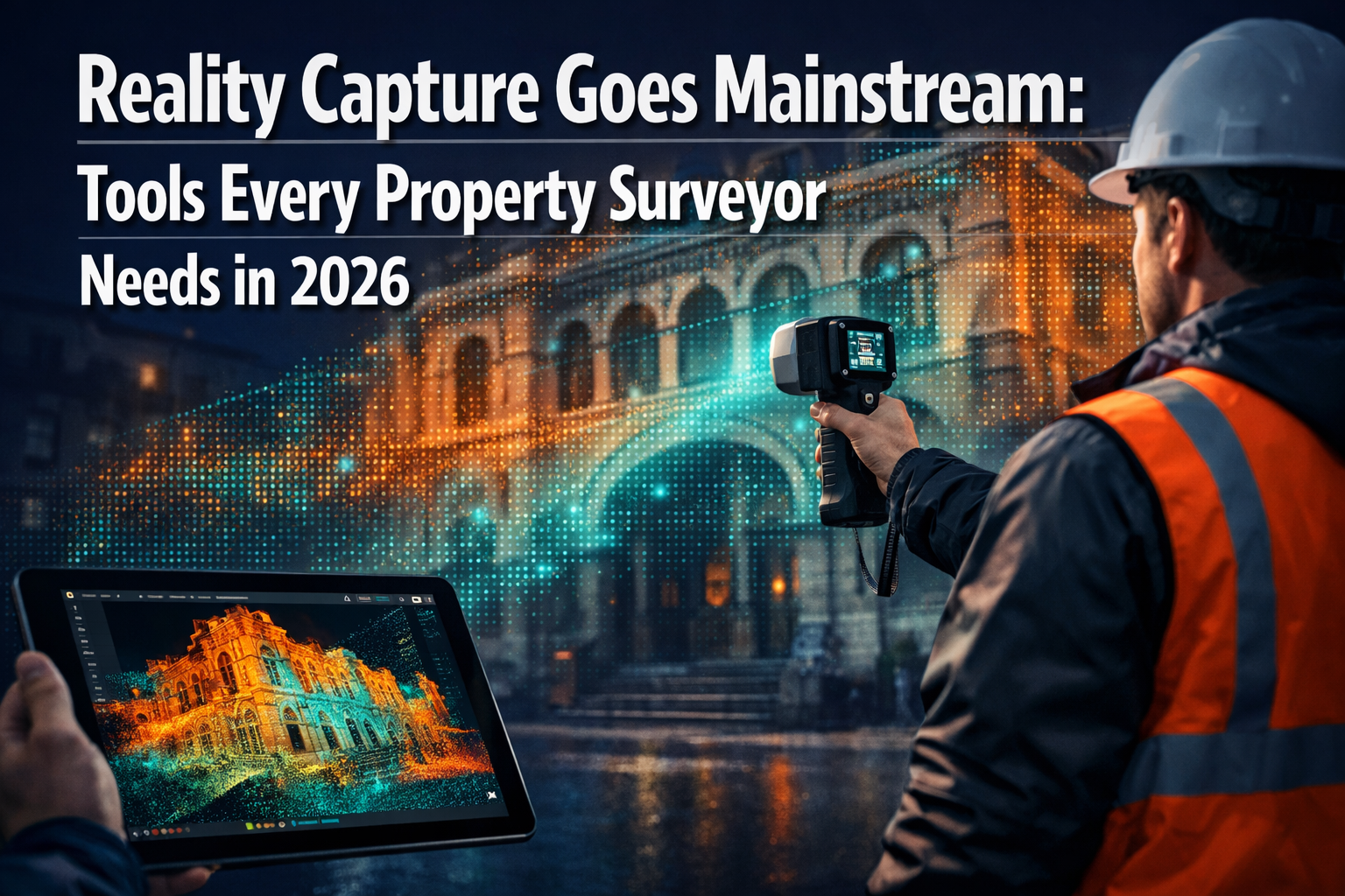
The property surveying industry is experiencing a technological revolution that seemed impossible just a few years ago. Reality capture technology, once reserved for large firms with substantial budgets, has now become accessible to surveyors of all sizes. As we navigate 2026, the democratization of reality capture goes mainstream, with tools every property surveyor needs becoming more affordable, powerful, and essential to competitive practice.
Gone are the days when capturing accurate 3D site data required expensive static laser scanners and days of field work. Today's reality capture systems leverage SLAM technology, artificial intelligence, and cloud-based processing to deliver survey-grade accuracy in a fraction of the time—and at price points that make adoption feasible for small and mid-sized firms. This transformation isn't just about new gadgets; it represents a fundamental shift in how surveyors document properties, communicate with clients, and deliver value.
Key Takeaways
- 📊 Survey-grade handheld SLAM systems now start at approximately $25,550, making professional reality capture accessible to smaller surveying practices
- ⚡ Dynamic scanning technology operates up to 10x faster than traditional static scanning methods while maintaining accuracy within 5mm
- 🤖 AI and cloud-based platforms are democratizing reality capture in 2026, enabling automated processing, quality assurance, and multi-format deliverables
- 🏗️ Clients increasingly expect digital deliverables including 3D models, point clouds, and digital twins as standard rather than traditional survey products alone
- 🔒 Safety and efficiency gains allow surveyors to document confined spaces, underground utilities, and hazardous areas without physical entry
Understanding Reality Capture Technology for Property Surveyors
Reality capture refers to the process of digitally documenting physical spaces and objects using advanced scanning technologies. For property surveyors, this means transforming buildings, land parcels, infrastructure, and construction sites into accurate digital representations that can be measured, analyzed, and shared.
What Makes Reality Capture Different from Traditional Surveying?
Traditional surveying relies on discrete measurements taken at specific points using total stations, GPS receivers, and measuring tapes. While accurate, this approach captures only the points you specifically target. Reality capture, by contrast, documents entire environments in rich detail, creating millions of data points that form comprehensive 3D models[1].
The key technologies powering reality capture include:
- LiDAR (Light Detection and Ranging): Uses laser pulses to measure distances and create precise point clouds
- Photogrammetry: Processes overlapping photographs to generate 3D models
- SLAM (Simultaneous Localization and Mapping): Enables devices to map environments while tracking their own position without GPS
- Structured light scanning: Projects patterns onto surfaces to capture detailed geometry
The Democratization Wave of 2026
According to Arnaud Lezennec, senior applications officer in the surveying industry, "Reality capture technology is already invaluable, but it will become even more democratized in 2026," with enhanced AI, machine learning, and cloud-based platforms enabling broader adoption[6]. This democratization manifests in three critical ways:
- Affordability: Entry-level professional systems now cost less than a mid-range total station
- Usability: Intuitive interfaces require minimal specialized training
- Processing power: Cloud-based platforms handle complex data processing without expensive local hardware
For chartered surveyors across London and beyond, this accessibility means reality capture is no longer a luxury—it's becoming a competitive necessity.
Essential Reality Capture Tools Every Property Surveyor Needs in 2026
The reality capture market in 2026 offers solutions ranging from smartphone-based systems to professional-grade handheld and wearable platforms. Understanding which tools match your practice's needs and budget is crucial for successful digital transformation.
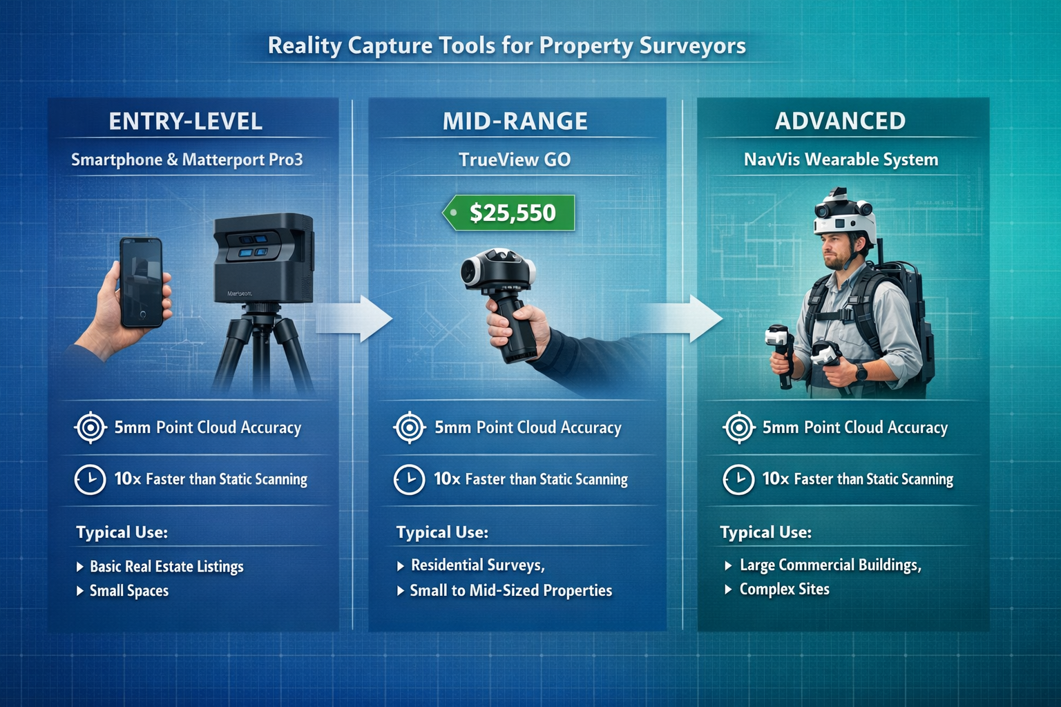
Entry-Level: Smartphone and Camera-Based Systems
Matterport Pro3 represents the accessible entry point for surveyors exploring reality capture. This camera-based system captures 3D data at distances up to 100 meters in less than 20 seconds per sweep, with automatic measurements and floor plans[4].
Key advantages:
- Low initial investment (under $10,000 for complete system)
- Intuitive operation requiring minimal training
- Automatic generation of floor plans and measurements
- Cloud-based processing and hosting
- Ideal for residential property documentation and building surveyor services
Limitations:
- Lower accuracy than LiDAR-based systems (typically ±1-2% of distance measured)
- Requires good lighting conditions
- Less effective in large outdoor environments
- Not suitable for ALTA surveys or engineering-grade applications
Mid-Range: Handheld SLAM LiDAR Systems
The TrueView GO handheld SLAM LiDAR system exemplifies the sweet spot for many surveying practices in 2026. Starting at $25,550, these systems deliver survey-grade accuracy with hardware powered by Hesai XT-16 (116S) or Hesai M2X (132S) sensors[2].
Performance specifications:
- ✅ Survey-grade accuracy suitable for professional deliverables
- ✅ SLAM-based positioning eliminates GPS dependency for interior work
- ✅ Rapid data capture in complex environments
- ✅ Seamless indoor/outdoor workflow integration
- ✅ Compatible with post-processing software like LP360 Land
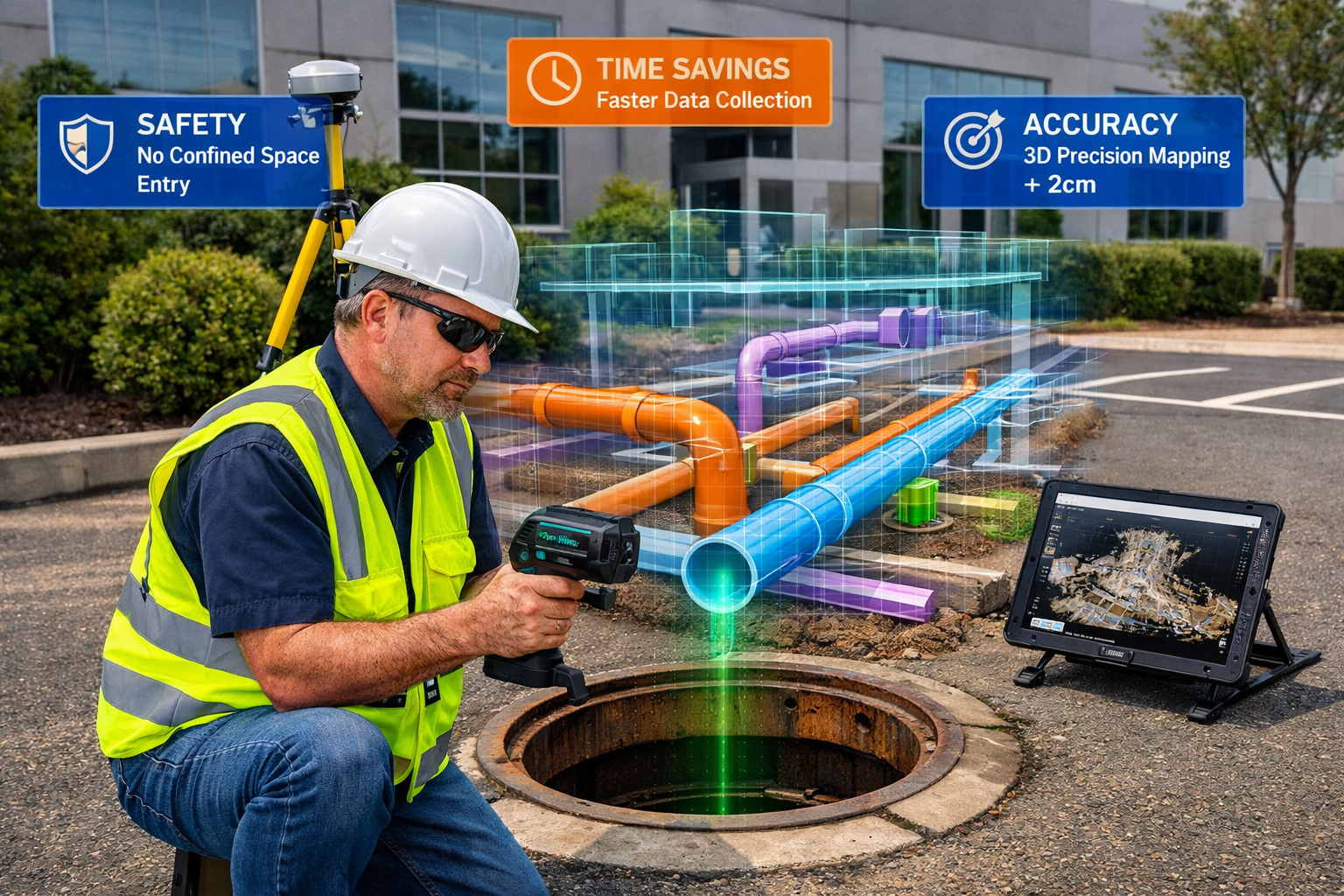
A real-world case study demonstrates the practical value: BSI Engineering and Surveying successfully documented over a dozen underground manholes using TrueView GO for an ALTA-compliant as-built survey, eliminating the need for workers to enter confined spaces[2]. This application alone can justify the investment through improved safety and reduced liability.
For surveyors conducting commercial property surveys in London and similar urban environments, handheld SLAM systems excel at capturing complex multi-story buildings, underground utilities, and tight interior spaces where traditional methods struggle.
Professional-Grade: Wearable and Dynamic Scanning Systems
NavVis reality capture systems represent the high-performance tier, operating up to 10x faster than static scanning in the field while achieving point cloud accuracy up to 5mm[3]. These wearable and cart-based systems are designed for large-scale projects where speed and comprehensive coverage are paramount.
Ideal applications:
- Large commercial facilities and industrial sites
- Campus-wide documentation projects
- Infrastructure corridors and transportation facilities
- Multi-building complexes requiring rapid turnaround
- Projects demanding the highest accuracy standards
The speed advantage translates directly to reduced field time and labor costs. What might require three days with static scanning can often be completed in a single day with dynamic systems—a compelling return on investment for firms with consistent project volume.
Comparison Table: Reality Capture Systems for 2026
| System Type | Price Range | Accuracy | Speed | Best For |
|---|---|---|---|---|
| Smartphone/Camera | $3,000-$10,000 | ±1-2% | Moderate | Residential, interior documentation |
| Handheld SLAM LiDAR | $25,000-$50,000 | ±5-10mm | Fast | Commercial surveys, confined spaces |
| Wearable/Dynamic | $50,000-$150,000+ | ±5mm | Very Fast | Large facilities, infrastructure |
| Static Terrestrial | $40,000-$100,000+ | ±2-5mm | Slow | Precision engineering, deformation monitoring |
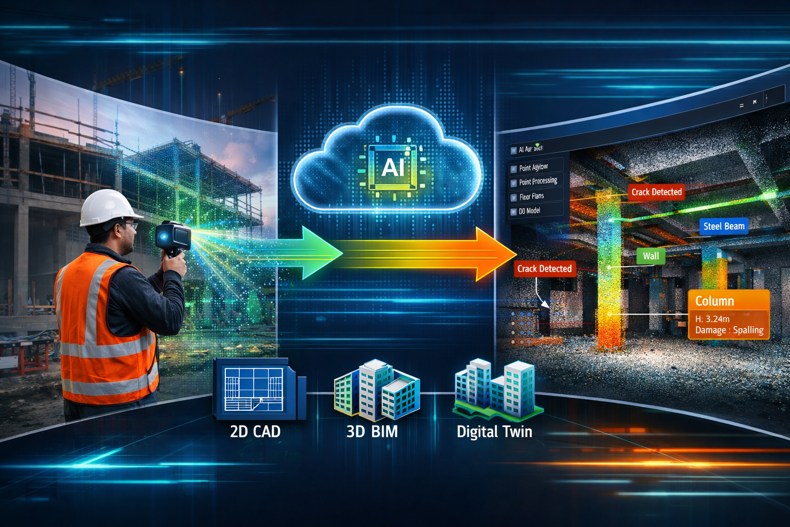
How Reality Capture Goes Mainstream: Integration into Core Surveying Workflows
Acquiring reality capture equipment represents only the first step. The true value emerges when these tools integrate seamlessly into daily surveying workflows, transforming how firms deliver services and communicate with clients.
Multi-Format Deliverable Production
Modern reality capture workflows produce diverse deliverables tailored to specific project needs[1]:
- 2D CAD drawings: Traditional plans, elevations, and sections extracted from point cloud data
- 3D BIM models: Building Information Models for design coordination and facility management
- Point clouds: Raw data for engineering analysis and as-built verification
- Digital twins: Interactive 3D models with embedded data for ongoing facility management
- Orthophotos and photorealistic renderings: Visual documentation for stakeholder communication
This versatility allows surveyors to serve multiple client needs from a single data capture session. A property valuation survey might generate floor plans for the valuation report, a 3D model for marketing purposes, and a digital twin for the property manager—all from one site visit.
Streamlined Post-Processing with AI Enhancement
Post-processing software in 2026 has evolved dramatically. Platforms like LP360 Land now enable visualization in 2D, 3D, Profile, and Immersive modes, with automated quality assurance, customizable issue lists, and direct export to CAD, BIM, and GIS formats[2].
AI-powered features accelerating workflows include:
- 🤖 Automatic feature extraction (walls, doors, windows, utilities)
- 🤖 Intelligent noise filtering and data cleanup
- 🤖 Automated measurement and dimensioning
- 🤖 Defect detection and condition assessment
- 🤖 Classification of point cloud elements
These capabilities reduce the manual labor traditionally required for data processing, allowing smaller firms to compete with larger competitors on turnaround time and deliverable quality.
Cloud-Based Collaboration and Client Access
Cloud platforms have become central to reality capture workflows in 2026. They enable:
- Real-time collaboration: Multiple team members can access and work with data simultaneously
- Client self-service: Stakeholders can view, measure, and extract information from 3D models without specialized software
- Version control: Automatic tracking of changes and updates throughout project lifecycle
- Cross-platform accessibility: Access from desktop, tablet, or smartphone devices
This accessibility creates a "common visual language" that helps all stakeholders align efforts and reduce misunderstandings[6]. When disputes arise during construction or renovation projects, the reality capture data provides objective documentation that can prevent costly conflicts.
For surveyors involved in party wall matters or boundary surveys, this visual documentation proves invaluable in clearly communicating conditions and measurements to all parties.
Practical Applications: Reality Capture Goes Mainstream Across Survey Types
The versatility of reality capture technology in 2026 extends across virtually every surveying discipline. Understanding specific applications helps firms identify high-value opportunities for implementation.
ALTA/NSPS Land Title Surveys
ALTA surveys demand exceptional accuracy and comprehensive documentation of property boundaries, improvements, easements, and encroachments. Reality capture enhances this traditional surveying service by:
- Documenting all visible improvements with millimeter precision
- Creating permanent visual records of property conditions
- Enabling office-based measurement verification
- Producing 3D visualizations that clarify complex spatial relationships
The BSI Engineering case study mentioned earlier demonstrates how handheld SLAM systems can document underground utilities and confined spaces for ALTA-compliant as-built surveys without safety risks[2].
Building Condition Assessments and Dilapidations
Schedule of dilapidations and condition surveys benefit enormously from reality capture's comprehensive documentation capabilities:
- Baseline documentation: Capture complete property conditions at lease commencement
- Progress tracking: Document deterioration or improvements over time
- Dispute resolution: Provide objective evidence of property conditions
- Remote assessment: Enable expert review without repeated site visits
For commercial building surveys in London, the ability to capture entire building exteriors and interiors in a single session dramatically reduces disruption to occupied properties while ensuring no defects are overlooked.
Construction Progress Monitoring
Reality capture has become integral to project management workflows in 2026, enabling real-time progress tracking and visual collaboration[6]. Regular scanning throughout construction allows:
- Comparison of as-built conditions against design models
- Early detection of deviations from plans
- Quantification of work completed for progress payments
- Documentation of concealed conditions before closure
- Quality assurance verification
Heritage Documentation and Conservation
Historic buildings present unique surveying challenges where non-contact documentation methods prove essential. Reality capture excels at:
- Recording intricate architectural details without physical contact
- Creating permanent digital archives of heritage assets
- Supporting restoration planning with accurate measurements
- Monitoring structural movement and deterioration over time
Surveyors working in historic areas like Camden or Hampstead find reality capture invaluable for documenting listed buildings and conservation areas.
Utility and Infrastructure Surveys
Underground utilities and infrastructure corridors benefit from SLAM-based systems that function without GPS dependency:
- Manhole and vault documentation without confined space entry
- Tunnel and culvert mapping with continuous scanning
- Pipeline and conduit routing documentation
- As-built verification for utility installations
The safety implications alone justify adoption for many infrastructure-focused surveying practices.
Overcoming Implementation Challenges: Making Reality Capture Work for Small Firms
While reality capture technology has become more accessible in 2026, successful implementation still requires thoughtful planning and realistic expectations. Small and mid-sized surveying practices face unique challenges when adopting these tools.
Budget Considerations and ROI Calculation
The initial investment in reality capture equipment represents a significant commitment for smaller firms. A realistic ROI analysis should consider:
Direct cost savings:
- Reduced field time (fewer site visits, shorter duration)
- Lower labor costs (fewer field personnel required)
- Decreased equipment rental expenses
- Reduced safety and insurance costs
Revenue opportunities:
- New service offerings (3D modeling, digital twins)
- Premium pricing for enhanced deliverables
- Faster project turnaround enabling higher volume
- Competitive differentiation in crowded markets
Hidden costs to budget for:
- Software licenses and subscriptions
- Cloud storage and processing fees
- Training and skill development
- Computer hardware upgrades for data processing
Many firms find that starting with mid-range handheld systems around $25,000-$30,000 provides the best balance of capability and affordability. This price point delivers professional-grade results while remaining accessible to practices generating $500,000+ in annual revenue.
Training and Skill Development
Reality capture technology in 2026 is more user-friendly than ever, but effective implementation still requires investment in training:
Field capture skills:
- Optimal scanning patterns for complete coverage
- Understanding when reality capture adds value versus traditional methods
- Equipment maintenance and troubleshooting
- Quality control during data collection
Processing and deliverable creation:
- Point cloud registration and cleanup
- Feature extraction and modeling
- Export to various formats (CAD, BIM, GIS)
- Quality assurance procedures
Most manufacturers offer comprehensive training programs, and many firms find that designating one or two team members as reality capture specialists creates internal expertise while maintaining operational efficiency.
Data Management and Storage Infrastructure
Reality capture generates substantial data volumes. A single building scan might produce 50-200 GB of point cloud data. Effective data management requires:
- Robust storage systems: Local servers or cloud storage with adequate capacity
- Backup protocols: Redundant storage preventing data loss
- Organization standards: Consistent naming conventions and folder structures
- Archival policies: Determining retention periods for raw and processed data
Cloud-based platforms increasingly handle these challenges automatically, though firms must budget for ongoing subscription costs.
Client Education and Expectation Management
As reality capture goes mainstream, client expectations evolve rapidly. Successful firms proactively educate clients about:
- What reality capture can and cannot deliver
- How digital deliverables differ from traditional survey products
- Appropriate applications for different technologies
- Pricing structures for enhanced services
Demonstrating sample projects and offering pilot programs helps clients understand value propositions. Many surveyors find that once clients experience the benefits of 3D models and point cloud data, they become advocates who refer additional business.
For practices offering expert surveyor advice across diverse applications, reality capture becomes a powerful tool for communicating complex spatial information to non-technical stakeholders.
The Strategic Advantage: Why Reality Capture Adoption Cannot Wait
The surveying industry in 2026 faces a critical inflection point. Firms integrating reality capture into core service offerings are differentiating themselves, as clients increasingly expect rich digital deliverables rather than traditional survey products alone[6].
Competitive Differentiation in Crowded Markets
Property surveying remains a competitive field, particularly in major metropolitan areas. Reality capture provides tangible differentiation:
- Visual impact: 3D models and interactive point clouds impress clients and win proposals
- Comprehensive documentation: Capture everything, measure anything approach reduces callbacks
- Faster turnaround: Dynamic scanning enables aggressive project schedules
- Value-added services: Digital twins and BIM models create ongoing client relationships
Surveyors operating across Surrey, Hertfordshire, and Buckinghamshire report that reality capture capabilities significantly influence client selection, particularly for commercial and institutional projects.
Meeting Evolving Client Expectations
Client expectations have fundamentally shifted. What was considered innovative in 2023 has become standard expectation in 2026. Clients now routinely request:
- Interactive 3D models they can navigate and measure
- Point cloud data for integration with their own systems
- Digital twins for facility management and operations
- Virtual site access for remote stakeholders
Firms unable to deliver these products risk losing market share to more technologically advanced competitors.
Industry Recognition and Strategic Positioning
The importance of reality capture to the surveying profession is highlighted by industry events like Geo Week 2026, taking place February 16-18 in Denver, Colorado. The Reality Capture Network (RCN) will host strategic sessions emphasizing reality capture's growing role in surveying and geospatial industries[7].
This mainstream recognition signals that reality capture has transitioned from emerging technology to essential capability. Forward-thinking firms are positioning themselves as digital leaders, attracting top talent and premium projects.
Future-Proofing Your Practice
Technology adoption in professional services follows predictable patterns. Early adopters gain competitive advantages, mainstream adoption becomes necessary for survival, and laggards struggle to catch up. Reality capture in 2026 sits firmly in the mainstream adoption phase.
Firms investing now in reality capture capabilities position themselves for success as:
- AI and machine learning further automate data processing
- Client expectations continue evolving toward digital-first deliverables
- Integration with other technologies (IoT sensors, augmented reality) creates new opportunities
- Regulatory requirements increasingly mandate digital documentation
The question for surveying practices is no longer whether to adopt reality capture, but how quickly they can implement it effectively.
Selecting the Right Reality Capture Solution for Your Practice
With numerous reality capture systems available in 2026, selecting the optimal solution requires careful evaluation of your practice's specific needs, project types, and growth objectives.
Assessment Framework: Matching Tools to Practice Profile
Consider these key factors:
1. Primary project types
- Residential properties: Camera-based systems may suffice
- Commercial buildings: Handheld SLAM systems offer best versatility
- Infrastructure and industrial: Wearable/dynamic systems justify investment
- Mixed portfolio: Mid-range handheld systems provide broadest applicability
2. Typical project scale
- Small properties (under 5,000 sq ft): Entry-level systems adequate
- Medium properties (5,000-50,000 sq ft): Handheld SLAM optimal
- Large facilities (over 50,000 sq ft): Dynamic systems maximize efficiency
- Campus or multi-building: Professional-grade systems essential
3. Accuracy requirements
- Visual documentation: ±1-2% sufficient
- General commercial surveys: ±10mm acceptable
- ALTA and engineering surveys: ±5mm or better required
- Precision monitoring: ±2mm necessary
4. Current technical capabilities
- Limited CAD/BIM experience: Cloud-based processing platforms essential
- In-house technical staff: Desktop processing software provides flexibility
- Existing software ecosystem: Ensure compatibility with current tools
Recommended Starting Points by Practice Size
Solo practitioners and small firms (1-3 surveyors):
- Start with Matterport Pro3 or similar camera-based system
- Focus on residential and small commercial applications
- Utilize cloud processing to minimize infrastructure investment
- Budget: $5,000-$15,000 initial investment
Mid-sized practices (4-10 surveyors):
- Invest in handheld SLAM LiDAR system (TrueView GO or equivalent)
- Target commercial, industrial, and ALTA survey applications
- Develop in-house processing capabilities
- Budget: $30,000-$50,000 initial investment
Larger firms (10+ surveyors):
- Deploy multiple systems matched to project types
- Consider professional-grade wearable/dynamic systems for large projects
- Establish dedicated reality capture department or specialists
- Budget: $75,000-$200,000+ initial investment
Vendor Evaluation Criteria
Beyond hardware specifications, evaluate vendors on:
- Training and support: Comprehensive onboarding programs and responsive technical assistance
- Software ecosystem: Processing tools, cloud platforms, and third-party integrations
- Update cycle: Frequency of firmware and software improvements
- User community: Active forums and knowledge sharing among users
- Service and warranty: Equipment repair, calibration, and replacement policies
Many firms find that vendor reputation and support quality matter more than minor specification differences between competing systems.
Integration with Traditional Surveying Methods
Reality capture does not replace traditional surveying methods—it complements and enhances them. The most effective practices in 2026 strategically combine technologies based on project requirements.
Hybrid Workflows: Best of Both Worlds
Optimal integration strategies:
Boundary and control surveys:
- Establish control network with total station or GPS
- Capture site details with reality capture
- Combine precise control with comprehensive documentation
Topographic surveys:
- Use reality capture for complex terrain and vegetation
- Supplement with traditional methods for specific features
- Verify critical elevations with conventional leveling
As-built documentation:
- Capture overall conditions with reality capture
- Verify critical dimensions with direct measurement
- Document concealed elements with traditional methods
This hybrid approach leverages each technology's strengths while mitigating weaknesses.
When Traditional Methods Remain Superior
Reality capture excels at comprehensive documentation but traditional surveying methods still prove superior for:
- Establishing precise horizontal and vertical control networks
- Measuring through dense vegetation or obstructions
- Documenting single points or linear features
- Working in extreme lighting conditions (very bright or very dark)
- Applications requiring legal-grade precision for boundary determination
Experienced surveyors recognize that technology selection should be driven by project requirements rather than preference for new tools.
Quality Assurance and Verification
Professional standards require verification of reality capture data:
- Check measurements against known dimensions
- Verify critical elevations with independent methods
- Confirm completeness of coverage before leaving site
- Document scanner positions and control points
- Maintain metadata for data provenance and accuracy assessment
These quality control procedures ensure reality capture deliverables meet professional standards and client expectations.
Conclusion: Embracing the Reality Capture Revolution in 2026
The transformation of property surveying through reality capture technology represents one of the most significant advances in the profession's history. What once required expensive equipment, specialized expertise, and substantial time investments has become accessible, efficient, and essential to competitive practice.
As reality capture goes mainstream in 2026, the tools every property surveyor needs are now within reach of practices of all sizes. From entry-level camera systems under $10,000 to professional handheld SLAM LiDAR platforms around $25,000, the barriers to adoption have fallen dramatically. Enhanced by AI-driven processing, cloud-based collaboration, and intuitive interfaces, these tools enable safer, faster, and more comprehensive site documentation than ever before.
Key Success Factors for Implementation
Successful reality capture adoption requires:
✅ Strategic assessment of practice needs and project types
✅ Realistic budgeting that accounts for equipment, software, training, and infrastructure
✅ Comprehensive training to develop field capture and processing skills
✅ Client education to communicate value and manage expectations
✅ Quality protocols ensuring professional standards and deliverable accuracy
✅ Continuous learning to keep pace with rapidly evolving capabilities
Actionable Next Steps
For surveying practices ready to embrace reality capture technology:
Immediate actions (this month):
- Assess your current project portfolio to identify high-value reality capture applications
- Research systems matching your practice profile and budget
- Connect with vendors to schedule demonstrations and trial periods
- Calculate realistic ROI based on your specific circumstances
Short-term implementation (next quarter):
- Acquire initial reality capture system matched to your primary applications
- Complete manufacturer training programs for designated team members
- Conduct pilot projects with existing clients to refine workflows
- Develop standard operating procedures for data capture and processing
Long-term development (next year):
- Expand service offerings incorporating reality capture deliverables
- Market enhanced capabilities to target clients and project types
- Evaluate results and consider additional systems or upgrades
- Establish your practice as a digital leader in your market
The surveying profession stands at a pivotal moment. Firms that embrace reality capture technology now will lead the industry's digital transformation, delivering superior value to clients while building sustainable competitive advantages. Those that delay risk falling behind as client expectations and industry standards continue evolving.
The tools are accessible. The technology is proven. The market is ready. The question is not whether to adopt reality capture, but how quickly your practice can implement it effectively. The future of property surveying is here—and it's captured in stunning 3D detail.
For surveyors seeking guidance on implementing these technologies or determining what survey type best suits specific project needs, professional consultation can accelerate successful adoption while avoiding costly missteps.
References
[1] Reality Capture – https://www.nederveld.com/reality-capture
[2] The Perfect Tool For Engineering And Surveying Alta Surveys – https://geocue.com/resources/articles/the-perfect-tool-for-engineering-and-surveying-alta-surveys/
[3] Surveying – https://www.navvis.com/industry/surveying
[4] 10 Ways 3d Scanner Technology Leads Efficiencies Surveying – https://matterport.com/blog/10-ways-3d-scanner-technology-leads-efficiencies-surveying
[5] Reality Capture Goes Mainstream Accessible Tools Transforming Property Surveys In 2026 – https://nottinghillsurveyors.com/blog/reality-capture-goes-mainstream-accessible-tools-transforming-property-surveys-in-2026
[6] Doubling Down On Digital – https://amerisurv.com/2026/02/01/doubling-down-on-digital/
[7] Geo Week 2026 Highlights Reality Capture S Strategic Role – https://www.gim-international.com/content/news/geo-week-2026-highlights-reality-capture-s-strategic-role
[8] Ai Driven Precision In Property Surveying How Artificial Intelligence Is Revolutionizing Workflows In 2026 – https://nottinghillsurveyors.com/blog/ai-driven-precision-in-property-surveying-how-artificial-intelligence-is-revolutionizing-workflows-in-2026