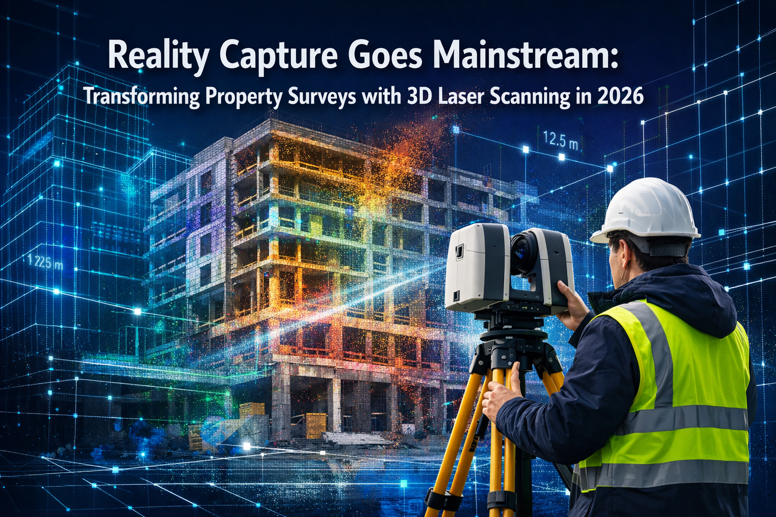
The property surveying industry stands at a remarkable inflection point in 2026. What was once considered cutting-edge technology reserved for high-budget projects has rapidly become accessible to firms of all sizes. Reality Capture Goes Mainstream: Transforming Property Surveys with 3D Laser Scanning in 2026 represents more than just technological advancement—it signals a fundamental shift in how professionals approach safety, speed, and precision in urban development projects. Traditional surveying methods, while reliable, can no longer keep pace with the demands of modern construction timelines, safety requirements, and accuracy expectations that define today's competitive landscape.
The transformation is evident across London and beyond, where chartered surveyors are integrating reality capture tools into everyday workflows. From comprehensive structural surveys to detailed commercial building assessments, 3D laser scanning technology has democratized access to millimeter-level precision that was previously unattainable for smaller practices.
Key Takeaways
✅ Market Expansion: The 3D laser scanner market is projected to reach $2.82 billion by 2030 with a 9.0% CAGR, reflecting widespread adoption across industries[6]
✅ Unprecedented Accuracy: Modern laser scanning delivers millimeter-level precision while capturing 1 million data points per second, eliminating manual measurement errors[3]
✅ Enhanced Safety: Reality capture technology allows surveyors to collect comprehensive data from safe distances, reducing exposure to hazardous environments in active construction zones
✅ Cost Efficiency: Firms can complete more projects with fewer site visits and smaller teams while reducing rework expenses through superior initial accuracy[2]
✅ Future-Ready Integration: AI and machine learning capabilities are transforming 3D scanning from documentation tools into predictive risk assessment platforms for 2026 and beyond[7]
Understanding Reality Capture Technology in Modern Property Surveys
What Is Reality Capture and How Does It Work?
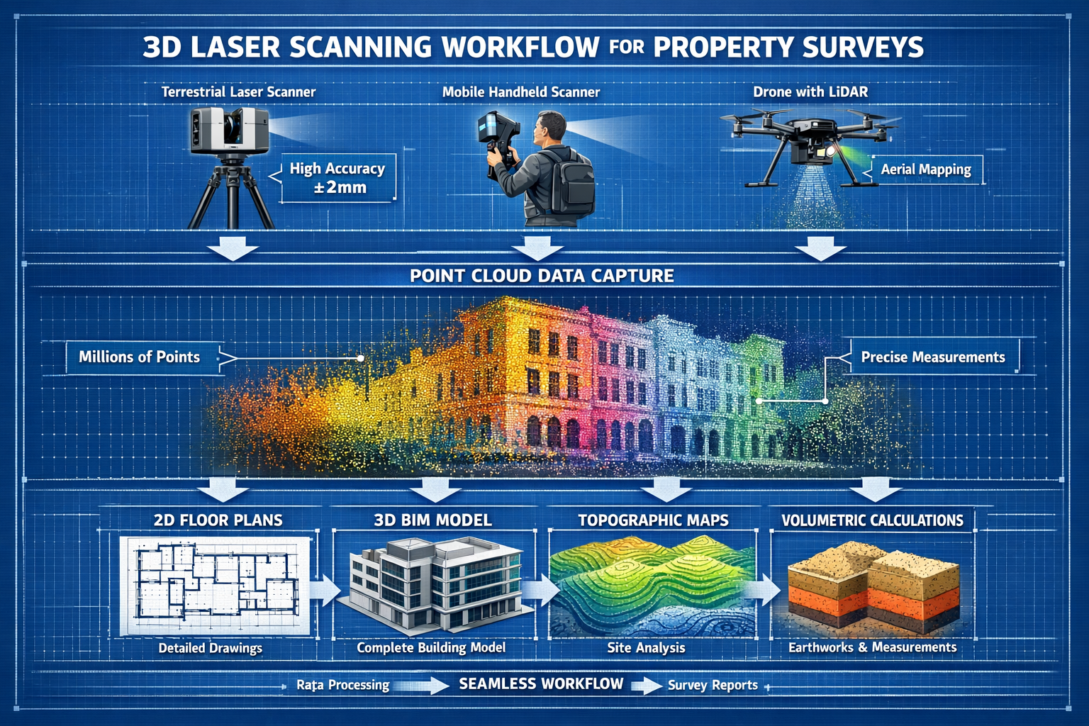
Reality capture refers to the process of digitally documenting physical spaces and objects with extreme precision using advanced scanning technologies. At its core, 3D laser scanning employs Light Detection and Ranging (LiDAR) technology to measure distances by illuminating targets with laser light and analyzing the reflected signals. The result is a dense collection of data points—called a point cloud—that creates a comprehensive digital representation of the surveyed environment.
Modern scanners operate with remarkable efficiency, recording 1 million points per second[3], which means a complete building exterior can be captured in minutes rather than the hours or days required for traditional measurement methods. Each point contains precise spatial coordinates (X, Y, Z) along with additional information such as color values and intensity measurements.
The captured data transforms into multiple deliverable formats:
| Output Type | Description | Primary Use Cases |
|---|---|---|
| Point Cloud | Raw 3D data with millions of measured points | Base dataset for all subsequent processing |
| 2D Drawings | Floor plans, elevations, sections | Architectural documentation, planning applications |
| 3D Models | BIM-compatible digital representations | Design coordination, clash detection |
| Topological Maps | Terrain and surface analysis | Site planning, drainage design |
| Volumetric Calculations | Precise volume measurements | Material estimation, earthwork analysis |
This versatility makes reality capture invaluable for building surveyor services requiring comprehensive documentation across multiple project phases.
The Evolution from Niche to Mainstream Adoption
The journey of 3D laser scanning from specialized application to mainstream surveying tool has accelerated dramatically. Just five years ago, the technology required substantial capital investment and specialized training that placed it beyond reach for many small and medium-sized practices. In 2026, the landscape has transformed completely.
Several factors have driven this mainstream adoption:
🔹 Affordability: Equipment costs have decreased significantly while capabilities have expanded, making entry-level professional scanners accessible to firms of all sizes
🔹 Portability: The proliferation of portable and handheld scanning devices[6] has eliminated the need for bulky, complex equipment that required multiple team members to operate
🔹 User-Friendly Software: Cloud-based processing platforms and intuitive interfaces have reduced the learning curve, allowing surveyors to integrate scanning into existing workflows quickly
🔹 Industry Standards: The February 2026 update to the ALTA/NSPS Guidelines[8] reflects how reality capture has become embedded in professional surveying standards for commercial real estate
🔹 Client Expectations: Property developers, architects, and contractors increasingly specify 3D scanning deliverables as standard requirements rather than optional extras
For practices offering specific defect reports or dilapidation surveys, reality capture provides irrefutable documentation that traditional photography and manual measurements cannot match.
Key Technologies Driving the Reality Capture Revolution
Multiple scanning technologies have matured simultaneously, creating a comprehensive toolkit for modern surveyors:
Terrestrial Laser Scanning (TLS): Tripod-mounted scanners remain the gold standard for millimeter accuracy[3] in architectural documentation. These systems excel in complex interior environments where precision is paramount, such as heritage buildings or facilities requiring exact as-built documentation.
Mobile Mapping Systems: Handheld and backpack-mounted scanners enable surveyors to create detailed 3D models from a wide variety of indoor and outdoor environments[4] while walking through spaces. This approach dramatically reduces capture time in large facilities like warehouses, hospitals, or educational campuses.
UAV/Drone LiDAR: Unmanned aerial vehicles equipped with laser scanners have become increasingly accessible and affordable[4], making aerial surveying standard practice for site analysis, topographic mapping, and infrastructure inspection. Drone applications excel in covering large areas quickly while accessing difficult or dangerous locations.
Photogrammetry Integration: While not laser-based, photogrammetric techniques often complement LiDAR data, particularly when color accuracy and visual documentation are priorities alongside geometric precision.
The convergence of these technologies allows surveyors to select the optimal tool for each project phase, maximizing efficiency without compromising accuracy.
Reality Capture Goes Mainstream: Practical Applications Transforming Property Surveys
Urban Development Projects: Speed and Safety in Constrained Environments
Urban construction sites present unique challenges that make reality capture particularly valuable. Active commercial environments undergoing renovations or expansions[1] cannot afford extended survey periods that disrupt business operations or compromise safety.
Consider a typical scenario: a commercial property owner in central London requires comprehensive documentation of a multi-story building for renovation planning. Traditional surveying would require:
- Multiple site visits over several days
- Physical access to all areas, including potentially hazardous zones
- Coordination with building occupants to access spaces
- Manual measurements susceptible to human error
- Weeks of drafting time to produce deliverables
With 3D laser scanning, the same project transforms:
✨ Single-Day Data Capture: Complete building documentation in one coordinated visit, minimizing disruption to tenants and operations
✨ Safe Distance Collection: Surveyors can capture detailed measurements of structural elements, facades, and roofing without scaffolding or elevated work platforms
✨ Comprehensive Coverage: Every visible surface is documented, eliminating the risk of missing critical details that require return visits
✨ Rapid Deliverables: Digital models can be produced within hours, with digital replicas available within hours rather than traditional extended timelines[4]
This efficiency proves especially valuable for roof surveys where traditional access methods pose significant safety risks and logistical challenges.
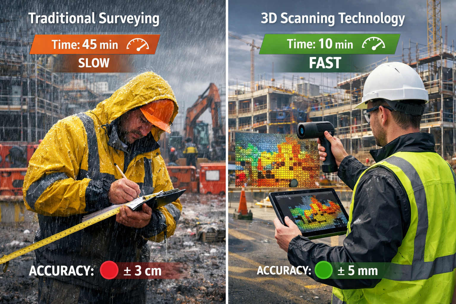
Accuracy That Prevents Costly Conflicts and Rework
The financial implications of measurement errors in construction projects can be substantial. Design conflicts discovered during construction, material over-ordering due to inaccurate quantities, and rework resulting from dimensional discrepancies all erode project budgets and timelines.
Reality Capture Goes Mainstream: Transforming Property Surveys with 3D Laser Scanning in 2026 addresses these challenges through unprecedented precision. LNE Surveys' recent announcement of enhanced 3D scanning capability highlights how the technology captures comprehensive spatial information through high-resolution scanners, producing precise point clouds and detailed digital representations of existing structures[1].
The practical benefits include:
📊 Millimeter Accuracy: Measurements accurate to within 2-3mm over distances of 100 meters eliminate the cumulative errors inherent in traditional tape-and-level methods[3]
📊 Complete Documentation: Nothing is missed—every pipe, beam, column, and surface detail is captured, providing a complete record for design teams
📊 Early Coordination: The centralized digital model approach enables early coordination between stakeholders, prevents unforeseen conflicts, and maintains team alignment[1] across disciplines
📊 Reduced Rework: Accurate as-built documentation ensures new design elements fit properly the first time, with high accuracy reducing rework expenses[2]
For projects requiring expert witness reports or documentation for construction dispute resolution, the irrefutable accuracy of laser-scanned data provides compelling evidence that traditional measurements cannot match.
Mobile Scanning: Accessibility for Firms of All Sizes
The emergence of mobile scanning systems represents perhaps the most significant democratizing force in reality capture technology. While early terrestrial scanners required substantial investment and specialized expertise, modern handheld and mobile systems have lowered barriers dramatically.
Key advantages of mobile scanning platforms:
🚀 Lower Capital Requirements: Entry-level professional mobile scanners cost a fraction of traditional terrestrial systems while delivering sufficient accuracy for most applications
🚀 Minimal Training: Intuitive interfaces allow surveyors to become proficient within days rather than months
🚀 Rapid Deployment: No tripod setup or station planning required—simply walk through the space while the system continuously captures data
🚀 Versatile Applications: Equally effective for interior spaces, exterior facades, and transitional areas that challenge stationary scanners
This accessibility enables smaller practices to compete for projects previously dominated by larger firms with specialized equipment. A two-person surveying team can now deliver the same comprehensive 3D documentation that once required dedicated scanning specialists and extensive equipment inventories.
The technology proves particularly valuable for snagging inspections where rapid documentation of defects across multiple properties is required, or for valuation reports requiring precise floor area calculations.
Operational Benefits: How Reality Capture Transforms Surveying Workflows
Reduced Labor Costs and Increased Project Capacity
The economic case for reality capture extends beyond accuracy improvements. Firms transitioning to 3D laser scanning discover they can perform more work with less manpower and time[2], fundamentally changing their operational economics.
Traditional surveying workflows typically involve:
- Initial site visit for measurements
- Return visits to capture missed details
- Extensive manual drafting and calculation
- Quality control reviews
- Revision cycles when errors are discovered
Reality capture compresses this timeline dramatically:
- Single comprehensive data capture session
- Automated processing and model generation
- Quality verification against point cloud
- Direct delivery of multiple output formats
The time savings compound across multiple projects. A surveying practice that previously completed 10 detailed building surveys monthly might increase capacity to 15-18 surveys with the same team size, representing a 50-80% productivity improvement without compromising quality.
Labor cost reductions manifest in several ways:
💰 Fewer Field Personnel: One surveyor with a mobile scanner can capture data that previously required a two or three-person team with traditional equipment
💰 Reduced Site Time: Complete data capture in hours rather than days minimizes billable time spent on-site while maximizing office-based processing efficiency
💰 Eliminated Return Visits: Comprehensive initial capture means survey teams make fewer field trips[2], reducing travel costs and schedule coordination challenges
💰 Safety Cost Avoidance: Staying safer during data collection[2] reduces insurance premiums, accident-related downtime, and liability exposure
These efficiencies allow firms to price services more competitively while maintaining healthy margins, or to redirect resources toward business development and service expansion.
Enhanced Safety in Hazardous Environments
The safety benefits of reality capture deserve particular emphasis, especially in urban development contexts where surveyors frequently encounter dangerous conditions. Traditional measurement methods often require physical access to:
⚠️ Active construction zones with heavy equipment operation
⚠️ Unstable structures with potential collapse risks
⚠️ Elevated locations requiring ladders or scaffolding
⚠️ Confined spaces with poor ventilation
⚠️ Areas with hazardous materials or contamination
⚠️ Traffic-adjacent locations on busy urban streets
3D laser scanning enables comprehensive data capture from safe standoff distances. A surveyor can document an unstable facade from across the street, capture complete roofing details from ground level, or record interior conditions of a contaminated space from a doorway—all while maintaining safe separation from hazards.
"The ability to capture complete building documentation without exposing our team to unnecessary risks has transformed our approach to challenging projects. We can now accept assignments we would have declined in the past due to safety concerns." – Senior Surveyor, Commercial Practice
This safety enhancement proves particularly valuable for practices offering commercial building surveys in active industrial facilities or dilapidation assessments of deteriorated structures.
Remote Collaboration and Stakeholder Alignment
The digital nature of reality capture data enables collaboration models impossible with traditional surveying outputs. A point cloud or 3D model can be shared instantly with stakeholders across multiple locations, allowing:
🌐 Virtual Site Visits: Clients, designers, and contractors can explore the surveyed environment remotely with measurement tools and annotation capabilities
🌐 Real-Time Design Reviews: Architects can overlay proposed designs on existing conditions to verify fit and identify conflicts before construction begins
🌐 Distributed Team Coordination: Project teams across different cities or countries can reference the same accurate spatial data simultaneously
🌐 Client Transparency: Property owners gain unprecedented visibility into their assets, building trust and facilitating informed decision-making
This centralized digital model approach[1] proves especially valuable for complex projects involving multiple disciplines. The structural engineer, MEP designer, and architect can all work from the same verified base model, ensuring coordination that prevents the costly conflicts endemic to projects based on outdated or inaccurate documentation.
For valuation purposes, the ability to provide clients with interactive 3D models alongside traditional reports adds substantial value and differentiation in competitive markets.
Reality Capture Goes Mainstream: Integration with Emerging Technologies in 2026
Artificial Intelligence and Machine Learning Applications
The convergence of reality capture with artificial intelligence represents the next frontier in property surveying. Property surveys in 2026 are increasingly incorporating AI and machine learning for predicting flood and landslide risks while automating inspection processes[7], transforming surveying from purely documentary to predictive and analytical.
AI-enhanced reality capture workflows now include:
🤖 Automated Feature Extraction: Machine learning algorithms identify and classify building elements (walls, doors, windows, mechanical systems) from point clouds, dramatically reducing manual modeling time
🤖 Defect Detection: AI systems trained on thousands of building scans can automatically identify common defects such as cracks, moisture damage, or structural deformations that human reviewers might miss
🤖 Change Detection: Comparing scans taken at different times reveals subtle movements, settlement, or deterioration patterns that inform maintenance priorities and risk assessments
🤖 Predictive Analytics: Historical scan data combined with environmental factors enables risk modeling for flood vulnerability, structural failure probability, or maintenance forecasting
These capabilities transform reality capture from a documentation tool into a comprehensive risk assessment platform. A structural survey enhanced with AI analysis provides not just current condition reporting but predictive insights about future performance and maintenance requirements.
The integration proves particularly valuable for portfolio management, where property owners need to prioritize capital expenditure across multiple assets based on objective condition data and predictive risk modeling.
Digital Twin Technology and Asset Lifecycle Management
The concept of digital twins—dynamic virtual replicas of physical assets that update throughout their lifecycle—has moved from theoretical framework to practical implementation in 2026. The growing adoption of digital twin technologies[6] in property management relies fundamentally on reality capture as the foundation for creating accurate initial models.
Digital twin workflows typically involve:
- Initial Capture: Comprehensive 3D scanning creates the baseline digital representation
- Continuous Updates: Periodic rescanning documents changes, renovations, and condition evolution
- Operational Integration: Sensor data, maintenance records, and performance metrics link to the spatial model
- Predictive Modeling: The combined dataset enables simulation and optimization of building systems
For property owners and facility managers, digital twins provide unprecedented visibility into asset performance. Energy consumption patterns can be analyzed spatially to identify inefficient zones. Maintenance histories attached to specific equipment inform replacement timing. Space utilization data supports reconfiguration decisions.
The long-term value proposition is compelling: a building documented through reality capture at construction completion becomes a living digital asset that accumulates knowledge throughout its operational life, supporting more informed decisions about renovations, system upgrades, and eventual disposition.
This approach aligns perfectly with the needs of clients seeking reinstatement cost valuations or comprehensive building condition assessments for insurance and financial planning purposes.
Drone Integration and Aerial Reality Capture
The maturation of UAV technology has created powerful synergies with terrestrial scanning. Drone applications have become standard in land surveying workflows[4], with increasingly affordable and accessible platforms bringing aerial reality capture within reach of practices of all sizes.
The complementary strengths of drone and ground-based scanning include:
✈️ Comprehensive Coverage: Drones capture roof conditions, site context, and large-area topography while terrestrial scanners document detailed building interiors and facades
✈️ Efficiency: Aerial scanning covers extensive sites in minutes, with modern systems capturing topographic data for dozens of acres in a single flight
✈️ Safety: Dangerous roof inspections, tall structure assessments, and hazardous terrain documentation occur without exposing personnel to risks
✈️ Perspective Variety: Combining nadir (straight-down), oblique, and terrestrial viewpoints creates complete models with no blind spots
The regulatory environment for commercial drone operations has stabilized in 2026, with streamlined certification processes and clear operational guidelines making aerial surveying a routine capability rather than a specialized service requiring extensive permissions.
For practices offering comprehensive property valuation services, the ability to provide clients with aerial context alongside detailed building documentation adds significant value and professional distinction.
Implementing Reality Capture: Practical Considerations for Surveying Practices
Equipment Selection for Different Practice Sizes and Specializations
The diversity of available reality capture systems means practices can select equipment aligned with their specific service offerings, project types, and budget constraints. Understanding the options helps firms make strategic investments that maximize return.
For Small Practices (1-3 Surveyors):
- Recommended: Handheld mobile scanners or smartphone-based photogrammetry systems
- Investment Range: £5,000-£15,000 for professional-grade mobile systems
- Ideal Applications: Residential surveys, small commercial properties, interior documentation
- Advantages: Minimal training requirements, highly portable, sufficient accuracy for most applications
For Medium Practices (4-10 Surveyors):
- Recommended: Mid-range terrestrial scanner plus mobile system for versatility
- Investment Range: £25,000-£60,000 for combined capability
- Ideal Applications: Commercial buildings, heritage documentation, renovation projects
- Advantages: Millimeter accuracy when needed, flexibility across project types, competitive differentiation
For Large Practices (10+ Surveyors):
- Recommended: Multiple terrestrial scanners, mobile systems, and drone platform
- Investment Range: £100,000+ for comprehensive fleet
- Ideal Applications: Large infrastructure, portfolio documentation, complex multi-building sites
- Advantages: Simultaneous project coverage, specialized tools for specific applications, maximum efficiency
Regardless of practice size, the trend toward portable and handheld scanning devices[6] means even small firms can access professional-grade reality capture without prohibitive capital requirements.
Training and Skill Development Requirements
The learning curve for reality capture technology has flattened considerably, but effective implementation still requires structured training and skill development. Modern systems emphasize user-friendly interfaces, but maximizing value requires understanding both technical operation and strategic application.
Essential Training Components:
📚 Equipment Operation: Physical scanner setup, calibration, data capture best practices (typically 1-2 days)
📚 Software Processing: Point cloud registration, cleaning, model generation, and output creation (3-5 days initial training)
📚 Quality Control: Verification procedures, accuracy assessment, error identification and correction (ongoing development)
📚 Project Planning: Scan position optimization, coverage verification, workflow efficiency (develops with experience)
📚 Client Communication: Explaining technology benefits, managing deliverable expectations, demonstrating value (critical for business development)
Many equipment manufacturers now provide comprehensive online training resources, certification programs, and ongoing support that accelerate skill development. Cloud-based processing platforms have eliminated much of the technical complexity that previously required specialized expertise.
The most successful implementations treat reality capture as a practice-wide capability rather than a specialized skill held by one or two individuals. Distributing knowledge across the team ensures operational resilience and maximizes equipment utilization.
Integration with Existing Workflows and Service Offerings
Strategic reality capture adoption extends beyond equipment purchase to thoughtful integration with established service offerings. The technology should enhance rather than disrupt existing client relationships and revenue streams.
Effective Integration Strategies:
🔧 Enhance Core Services: Add 3D documentation to existing survey products without changing fundamental service structure—clients receive traditional reports plus interactive models
🔧 Tiered Service Levels: Offer basic surveys with traditional methods and premium options with reality capture, allowing clients to select based on project requirements and budget
🔧 Specialized Applications: Develop niche expertise in specific reality capture applications (heritage documentation, industrial facilities, complex renovations) that differentiate the practice
🔧 Collaborative Partnerships: Partner with architects, engineers, and contractors who need reality capture services but lack in-house capability, creating referral relationships
🔧 Recurring Revenue: Offer periodic rescanning services for condition monitoring, change detection, and digital twin updates, creating ongoing client relationships beyond one-time surveys
For practices offering expert witness services, reality capture provides compelling evidence documentation that strengthens case presentations and professional credibility.
The key is viewing reality capture as a capability that amplifies existing expertise rather than a separate service line requiring entirely new market positioning.
Future Outlook: Where Reality Capture Technology Is Heading
Market Growth Projections and Industry Adoption Trends
The trajectory for reality capture technology points toward continued rapid expansion and deepening integration across the property sector. The projection that the 3D laser scanner market will reach $2.82 billion by 2030 with a CAGR of 9.0%[6] reflects robust demand driven by multiple converging factors.
Key Growth Drivers Through 2030:
📈 Construction Industry Digitalization: Building Information Modeling (BIM) mandates and digital delivery requirements make reality capture essential for as-built documentation
📈 Infrastructure Investment: Government infrastructure programs globally require comprehensive documentation and monitoring, driving demand for large-scale scanning projects
📈 Insurance and Risk Management: Insurers increasingly require detailed property documentation and condition assessment, creating new market segments for reality capture services
📈 Heritage Preservation: Cultural institutions and preservation organizations adopt scanning to document historic structures before they deteriorate further
📈 Regulatory Evolution: Updated standards like the 2026 ALTA/NSPS Guidelines[8] incorporate reality capture methodologies, normalizing their use in commercial transactions
The technology's transition from specialized application to standard practice mirrors the historical adoption curves of GPS, total stations, and other surveying innovations that initially seemed exotic but became indispensable.
Emerging Capabilities and Technology Convergence
The reality capture landscape continues evolving rapidly, with several emerging capabilities poised to further transform property surveying:
🔮 Real-Time Processing: Cloud computing advances enable field processing of scan data, with preliminary models available before surveyors leave the site
🔮 Augmented Reality Integration: AR headsets overlay digital models onto physical environments, enabling on-site verification and stakeholder visualization during surveys
🔮 Automated Reporting: AI systems generate draft survey reports directly from point cloud analysis, reducing documentation time from days to hours
🔮 Sensor Fusion: Integration of thermal imaging, moisture detection, and other sensors with geometric scanning creates comprehensive condition assessments in single capture sessions
🔮 Miniaturization: Continued size and weight reductions make professional-grade scanners increasingly portable and accessible
🔮 Standardization: Industry-wide data format standards improve interoperability between different scanning systems and software platforms
These developments will further democratize access to reality capture while expanding its applications beyond traditional surveying into facilities management, insurance assessment, and property marketing.
Preparing Your Practice for the Reality Capture Future
Forward-thinking surveying practices can position themselves advantageously by taking strategic steps now:
✅ Start Small, Scale Strategically: Begin with accessible mobile scanning technology to develop capabilities and client demand before major capital investments
✅ Develop Specialization: Identify niche applications where reality capture provides maximum differentiation and value in your specific market
✅ Build Digital Literacy: Invest in team training not just for scanning operation but for digital workflows, cloud collaboration, and data management
✅ Cultivate Partnerships: Establish relationships with technology providers, software vendors, and complementary professionals who can support capability development
✅ Communicate Value: Develop clear messaging about reality capture benefits that resonates with clients focused on accuracy, safety, and project efficiency
✅ Monitor Standards: Stay informed about evolving professional standards and regulatory requirements that may mandate or incentivize reality capture adoption
The firms that thrive in the coming decade will be those that view Reality Capture Goes Mainstream: Transforming Property Surveys with 3D Laser Scanning in 2026 not as a temporary trend but as a fundamental shift in professional practice requiring strategic adaptation.
Conclusion: Embracing the Reality Capture Revolution

The transformation of property surveying through 3D laser scanning represents one of the most significant technological shifts in the profession's history. Reality Capture Goes Mainstream: Transforming Property Surveys with 3D Laser Scanning in 2026 is not hyperbole—it describes the current state of an industry where these tools have moved from specialized applications to everyday practice across firms of all sizes.
The compelling advantages are clear: millimeter-level accuracy that eliminates costly errors, enhanced safety that protects survey teams from hazardous environments, operational efficiency that allows practices to complete more projects with existing resources, and client value that differentiates services in competitive markets.
The accessibility revolution driven by portable and handheld devices, declining equipment costs, and user-friendly software has removed the barriers that once limited reality capture to large, well-capitalized firms. Today, a two-person practice can deliver the same comprehensive 3D documentation that required specialized teams just a few years ago.
Looking forward, the integration of reality capture with artificial intelligence, digital twin technology, and predictive analytics promises to transform surveying from a purely documentary discipline into a strategic advisory service. Surveyors who embrace these capabilities position themselves as essential partners in property development, management, and risk assessment rather than commodity service providers.
Actionable Next Steps
For surveying practices ready to embrace reality capture technology:
-
Assess Your Current Capabilities: Evaluate which projects would benefit most from 3D scanning based on accuracy requirements, safety challenges, or client demands
-
Research Equipment Options: Contact manufacturers for demonstrations of mobile and terrestrial systems appropriate for your typical project types and budget
-
Invest in Training: Allocate resources for comprehensive team training that develops both technical operation skills and strategic application knowledge
-
Start with Pilot Projects: Select several upcoming projects to test reality capture workflows, refine processes, and develop client communication approaches
-
Develop Service Offerings: Create clear service descriptions and pricing structures that communicate reality capture value to existing and prospective clients
-
Build Strategic Partnerships: Connect with architects, engineers, and developers who need reality capture services to establish referral relationships
-
Stay Informed: Monitor industry publications, attend conferences, and engage with professional organizations to track evolving standards and best practices
The surveying profession stands at a pivotal moment. The firms that recognize Reality Capture Goes Mainstream: Transforming Property Surveys with 3D Laser Scanning in 2026 as an opportunity rather than a threat will lead the industry into its digital future, delivering unprecedented value to clients while building more efficient, profitable, and safer practices.
The question is no longer whether to adopt reality capture technology, but how quickly your practice can integrate these tools to remain competitive in a rapidly evolving marketplace. The mainstream moment has arrived—the time to act is now.
References
[1] Lne Surveys Improves Accuracy During Surveying Through 3d Scanning Technology – https://tech.einnews.com/pr_news/890663153/lne-surveys-improves-accuracy-during-surveying-through-3d-scanning-technology
[2] 3d Laser Scanning Used In Land Surveying – https://www.duncan-parnell.com/blog/108/3d-laser-scanning-used-in-land-surveying
[3] Adopting Accuracy 3d Laser Scanning Lidar In Construction – https://blog.brightergraphics.com/adopting-accuracy-3d-laser-scanning-lidar-in-construction
[4] The Future Of Land Surveying Technology And Upcoming Trends In 2026 – https://metricop.com/blogs/land-surveying/the-future-of-land-surveying-technology-and-upcoming-trends-in-2026
[5] How Technology Is Revolutionizing Land Surveys – https://www.firstchoicesurveying.com/blog/how-technology-is-revolutionizing-land-surveys
[6] Key Strategic Developments And Emerging Changes Shaping The 3d – https://www.openpr.com/news/4364641/key-strategic-developments-and-emerging-changes-shaping-the-3d
[7] Revolutionizing Property Surveys How Ai And Machine Learning Are Predicting Risks In 2026 – https://nottinghillsurveyors.com/blog/revolutionizing-property-surveys-how-ai-and-machine-learning-are-predicting-risks-in-2026
[8] What 2026 Alta Nsps Updates Mean For Cre Professionals – https://www.partneresi.com/resources/articles/what-2026-alta-nsps-updates-mean-for-cre-professionals/