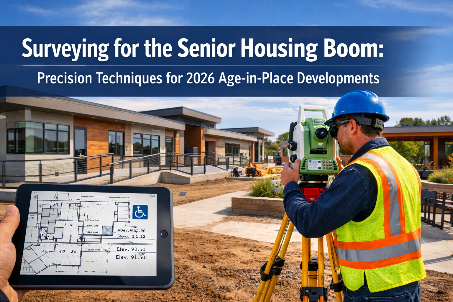
The oldest baby boomers are turning 80 in 2026, creating an unprecedented wave of demand for senior housing that the industry has never experienced before. With occupancy rates reaching 88.7% as of Q3 2025 and independent living facilities surpassing 90% for the first time since 2019[1], the pressure is on developers to build specialized communities quickly and efficiently. However, surveying for the senior housing boom requires far more than traditional land assessment techniques. Surveying for the Senior Housing Boom: Precision Techniques for 2026 Age-in-Place Developments demands specialized knowledge of accessibility requirements, wellness-focused site planning, and technology integration that supports aging residents while maintaining construction efficiency.
This surge in demand comes at a critical time when new construction sits at historic lows—fewer than 1,500 new units were added in Q3 2025, representing just 0.7% year-over-year growth, the lowest since 2006[1]. Nearly 60% of the 140 markets tracked have no new senior housing development projects underway[1], creating an estimated $800 billion supply gap through 2041 if current development pace continues[1]. Surveyors who master the precision techniques required for age-in-place developments will find themselves at the forefront of one of the most significant construction booms in modern history.
Key Takeaways
✅ Demographic urgency: The age 75+ population will grow by more than 4 million by 2030, requiring surveyors to prioritize accessibility-focused site assessments and ADA-compliant measurements[2]
✅ Technology integration: Modern senior housing developments demand precision surveying for tech-enabled facilities, including smart home systems, emergency response infrastructure, and wellness monitoring equipment
✅ Specialized site features: Surveyors must account for unique elements like accessible ramps (1:12 maximum slope ratios), wellness gardens with therapeutic pathways, single-story modular construction, and emergency vehicle access routes
✅ Supply gap opportunity: With an $800 billion development shortfall projected through 2041, surveyors equipped with age-in-place expertise will be essential partners in addressing this critical housing need[1]
✅ Evolving development models: New "independent living lite" (IL Lite) concepts and unbundled service models require flexible site planning that accommodates changing resident needs over time[2]
Understanding the 2026 Senior Housing Market Landscape
The Demographic Imperative Driving Development
The numbers tell a compelling story. As the oldest baby boomers celebrate their 80th birthdays in 2026, the senior housing industry faces a demographic tsunami that will reshape development priorities for decades to come. The U.S. Census Bureau projects the age 75+ population will expand by more than 4 million people by 2030[2], creating demand that far outstrips current supply.
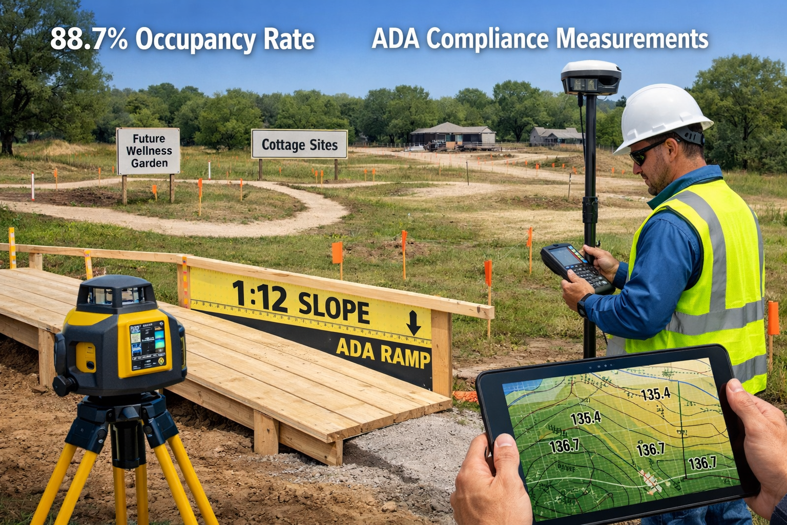
Industry-wide occupancy reached 88.7% as of Q3 2025, with expectations to approach 90% throughout 2026[1]. Independent living facilities have already surpassed the 90% threshold for the first time since 2019[1], signaling that the market has fully recovered from pandemic-era challenges and entered a new growth phase.
However, the supply side presents a stark contrast to this robust demand. New construction activity remains at historic lows, with fewer than 1,500 new units added in Q3 2025—representing just 0.7% year-over-year growth, the lowest expansion rate since 2006[1]. This construction drought means the industry would need to develop at twice its maximum historical pace annually for the next 20 years just to maintain 90% occupancy levels[1].
Market Gaps Creating Surveying Opportunities
The dramatic imbalance between supply and demand creates exceptional opportunities for surveyors who understand the unique requirements of senior housing developments. Nearly 60% of the 140 markets tracked have no new senior housing development projects underway[1], a dramatic shift from just three years ago when construction activity was significantly more robust.
This market gap translates to an estimated $800 billion supply shortfall at current development pace through 2041[1]. For professional surveyors, this represents not just a business opportunity but a critical infrastructure challenge that requires specialized expertise in age-in-place design principles, accessibility compliance, and wellness-focused site planning.
Professional structural survey expertise becomes particularly valuable when assessing existing properties for senior housing conversions or evaluating sites for new construction that must meet stringent safety and accessibility standards.
Surveying for the Senior Housing Boom: Essential Site Assessment Techniques
Topographic Analysis for Accessibility Compliance
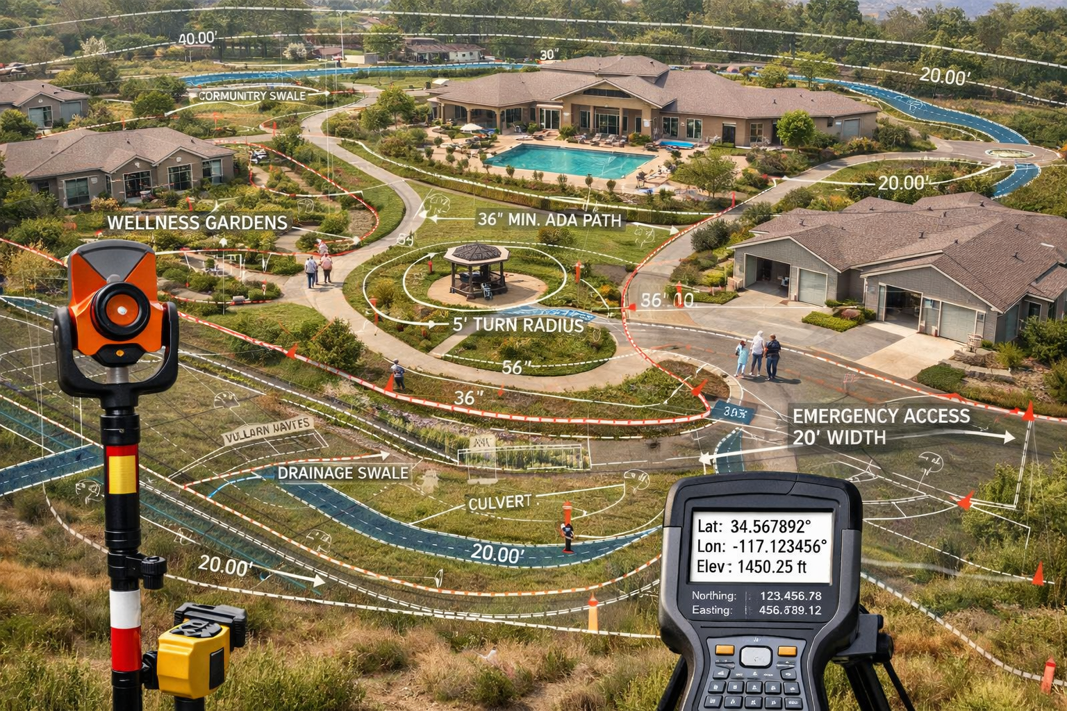
The foundation of any successful age-in-place development begins with comprehensive topographic surveying that identifies opportunities and challenges for creating accessible environments. Unlike conventional residential developments, senior housing projects require meticulous elevation mapping to ensure all pathways, entrances, and outdoor amenities meet or exceed Americans with Disabilities Act (ADA) standards.
Key topographic considerations include:
- Slope analysis for pathway design: Maximum 1:12 (8.33%) gradient for accessible ramps, with detailed contour mapping to identify natural grade changes
- Drainage planning: Ensuring water management systems don't create puddles or ice hazards on walking surfaces
- Emergency vehicle access: Identifying routes that maintain appropriate grades for ambulances and fire trucks while remaining accessible to residents
- Foundation planning: Mapping subsurface conditions for single-story construction that minimizes excavation and supports modular building techniques
Surveyors must produce detailed contour maps with 6-inch interval accuracy rather than the standard 1-foot or 2-foot intervals used in conventional residential projects. This precision enables architects and engineers to design seamless transitions between indoor and outdoor spaces, minimize the need for ramps, and create naturally accessible environments.
Boundary and Utility Surveying for Multi-Use Spaces
Modern age-in-place developments incorporate diverse amenity spaces that require careful boundary delineation and utility planning. The growing trend toward single-story cottages and villas with attached garages[2] replacing traditional multistory units means larger site footprints with more complex utility distribution networks.
Critical boundary and utility surveying elements include:
| Survey Component | Senior Housing Requirement | Precision Standard |
|---|---|---|
| Property boundaries | Clear delineation for wellness gardens, walking paths | ±0.1 feet |
| Utility corridors | Accessible maintenance routes, emergency shutoffs | ±0.5 feet |
| Setback verification | ADA-compliant spacing between buildings | ±0.2 feet |
| Easement mapping | Service vehicle access, emergency egress | ±0.3 feet |
| Underground utilities | Medical gas lines, backup power systems | ±0.1 feet |
The unbundling of services and care to allow customizable resident options[2] means utility infrastructure must be designed with flexibility in mind. Surveyors need to map potential connection points for future expansion, identify optimal locations for distributed utility hubs, and ensure redundancy for critical systems like emergency power and medical gas distribution.
Working with expert surveyor advice ensures that boundary and utility surveys account for the unique operational requirements of senior housing facilities, including maintenance access that doesn't disrupt resident activities and utility placement that supports aging-in-place modifications.
Site Planning for Wellness and Therapeutic Landscapes
One of the most distinctive aspects of Surveying for the Senior Housing Boom: Precision Techniques for 2026 Age-in-Place Developments involves planning for wellness gardens, therapeutic walking paths, and outdoor activity spaces that support physical and cognitive health. These features have evolved from optional amenities to essential components of age-in-place communities.
Precision surveying for wellness landscapes requires:
🌳 Therapeutic pathway mapping: Circular or figure-eight routes that provide varied walking distances (typically 200-foot, 400-foot, and 800-foot loops) with consistent, gentle grades
🌻 Sensory garden placement: Level planting areas at accessible heights (24-30 inches) with adequate turning radii for wheelchairs and walkers
🪑 Rest area positioning: Seating alcoves spaced at 100-foot intervals along pathways, with level pads and appropriate drainage
☀️ Sun/shade analysis: Seasonal shadow mapping to ensure comfortable outdoor spaces throughout the day and year
💧 Water feature integration: Fountain and pond locations that provide therapeutic benefits while maintaining safety setbacks from pathways
Surveyors must work closely with landscape architects to translate wellness design concepts into buildable site plans. This collaboration requires understanding how elevation changes affect perceived safety for residents with mobility challenges, how sight lines contribute to wayfinding for those with cognitive impairments, and how material transitions (grass to pavement, concrete to brick) can be designed to minimize trip hazards.
Advanced Precision Techniques for Modern Senior Housing Projects
GPS and Total Station Integration for Large-Scale Developments
Modern senior housing campuses often span multiple acres and include numerous buildings, amenities, and outdoor spaces. GPS-based surveying systems combined with traditional total station equipment provide the accuracy and efficiency needed to map these complex sites while maintaining the precision required for accessibility compliance.
The integration approach offers several advantages:
GPS for macro-level site control: Establishing primary control points across the entire development site with centimeter-level accuracy using Real-Time Kinematic (RTK) or Network RTK systems. This creates a consistent coordinate framework that ensures all buildings, pathways, and amenities align properly even when constructed in multiple phases over several years.
Total station for micro-level precision: Conducting detailed measurements for critical elements like ramp slopes, doorway widths, turning radii, and threshold elevations where millimeter-level accuracy is essential for ADA compliance and resident safety.
Data integration through BIM: Combining GPS and total station data into Building Information Modeling (BIM) platforms that allow real-time coordination between surveyors, architects, engineers, and contractors. This integration is particularly valuable for modular construction projects where factory-built components must align precisely with site-prepared foundations and utilities.
For developments across regions like Surrey or Buckinghamshire, this integrated approach ensures consistency across multiple project sites while adapting to local topographic and regulatory variations.
3D Laser Scanning for Existing Building Conversions
With new construction at historic lows, many developers are converting existing buildings into senior housing facilities. 3D laser scanning technology has become indispensable for these adaptive reuse projects, providing comprehensive documentation of existing conditions that inform conversion feasibility and design decisions.
Key applications of laser scanning include:
✨ Accessibility assessment: Capturing precise measurements of existing doorways, corridors, stairways, and elevators to determine compliance gaps and renovation requirements
✨ Structural evaluation: Creating detailed point cloud data that structural engineers use to assess load-bearing capacity for potential modifications, particularly when adding accessibility features like ramps or elevators
✨ MEP coordination: Documenting existing mechanical, electrical, and plumbing systems to plan integration of senior-specific infrastructure like emergency call systems, enhanced HVAC for air quality, and medical gas lines
✨ Space planning verification: Providing architects with accurate as-built dimensions for designing resident units, common areas, and therapy spaces that meet senior housing standards
The point cloud data from 3D laser scanning creates a digital twin of the existing building, allowing design teams to test various conversion scenarios virtually before committing to expensive physical modifications. This technology is particularly valuable when working with historic buildings or unique architectural features that developers want to preserve while adding modern accessibility features.
Professional commercial building survey expertise becomes essential when evaluating existing structures for senior housing conversion, ensuring that all accessibility modifications are properly documented and compliant with current regulations.
Drone-Based LiDAR for Rapid Site Assessment
Unmanned Aerial Systems (UAS) equipped with LiDAR sensors have revolutionized preliminary site assessment for senior housing developments, particularly for large parcels or sites with challenging terrain. Drone-based surveying provides comprehensive topographic data in a fraction of the time required for traditional ground-based methods.
Benefits of drone LiDAR for senior housing projects:
📍 Rapid topographic mapping: Capturing detailed elevation data across entire development sites in hours rather than days, accelerating project timelines in a market where speed-to-occupancy directly impacts financial returns
📍 Vegetation penetration: LiDAR's ability to see through tree canopy provides accurate ground surface models even on heavily wooded sites, revealing topographic features that affect accessibility planning
📍 Volumetric calculations: Precise cut-and-fill analysis for grading plans that minimize earthwork costs while achieving accessibility objectives
📍 Drainage modeling: High-resolution terrain data enables sophisticated stormwater analysis, ensuring proper drainage around buildings and along pathways to prevent standing water and ice formation
📍 Preliminary design visualization: Creating 3D terrain models that help stakeholders visualize how proposed buildings and amenities will fit within the natural landscape
The efficiency gains from drone-based surveying are particularly valuable given the industry's need to develop at twice its maximum historical pace[1] to meet demand. However, surveyors must ensure drone operations comply with FAA regulations and maintain the accuracy standards required for final construction documentation.
Surveying for the Senior Housing Boom: Specialized Considerations for Age-in-Place Features
Accessible Ramp and Pathway Precision Measurements
Perhaps no single element of senior housing design requires more surveying precision than accessible ramps and pathways. ADA standards mandate maximum slopes of 1:12 (8.33%) for ramps, with stricter requirements for certain applications. Even minor deviations from these standards can create safety hazards or compliance violations.
Critical measurement protocols include:
Slope verification at multiple points: Measuring grade at 5-foot intervals along the entire ramp length, not just at endpoints, to identify any mid-span deviations that could exceed maximum allowable slopes
Cross-slope monitoring: Ensuring perpendicular slopes don't exceed 1:48 (2.08%) to prevent wheelchairs from veering off course or creating instability for walkers
Landing dimensions: Verifying that ramp landings meet minimum 60-inch by 60-inch requirements and remain level within 1:48 in all directions
Handrail positioning: Confirming handrail mounting heights (34-38 inches) and extensions (12 inches beyond ramp top and bottom) meet code requirements
Surface transitions: Documenting that transitions between different surface materials (concrete to asphalt, pavement to brick) have maximum 0.5-inch vertical discontinuities with beveled edges
Surveyors must use digital levels or total stations with automatic target recognition to achieve the precision required for ramp verification. Traditional hand levels or builder's levels lack the accuracy needed to confidently certify compliance with accessibility standards.
The importance of this precision cannot be overstated. Ramps that exceed maximum slopes create genuine safety risks for residents using wheelchairs, walkers, or canes. Conversely, ramps that are too gradual consume valuable site area and increase construction costs unnecessarily.
Modular Construction Coordination and Foundation Surveying
The trend toward single-story cottages and villas[2] in senior housing developments often involves modular or prefabricated construction techniques that accelerate project delivery. However, modular construction demands exceptional surveying precision because factory-built components have minimal tolerance for foundation irregularities.
Foundation surveying for modular senior housing requires:
🔧 Sub-millimeter foundation placement: Establishing foundation corners and anchor bolt locations within ±3mm tolerances to ensure modular units fit properly without field modifications
🔧 Elevation control: Maintaining foundation top elevations within ±6mm across the entire building footprint to prevent structural stress when modular units are joined
🔧 Dimensional verification: Confirming foundation dimensions match modular unit specifications exactly, as even minor discrepancies can prevent proper assembly
🔧 Utility stub-out positioning: Placing plumbing, electrical, and HVAC connection points within ±12mm of specified locations to align with factory-installed systems
🔧 Quality assurance documentation: Providing certified as-built surveys before modular delivery to confirm foundations are ready to receive units
The precision required for modular construction surveying exceeds typical residential standards by an order of magnitude. Surveyors must use robotic total stations with automated measurement routines and implement rigorous quality control procedures to achieve these tolerances consistently.
This level of precision becomes even more critical when modular units include pre-installed accessibility features like roll-in showers, grab bars, and emergency call systems. Any foundation irregularities that force field modifications can compromise these factory-installed safety features.
Technology Infrastructure and Smart Building Integration
Modern age-in-place developments incorporate extensive technology infrastructure that supports independent living while providing safety monitoring and emergency response capabilities. Surveying for these tech-enabled facilities requires planning for equipment locations, cable routes, and sensor placements that weren't considerations in traditional senior housing.
Technology infrastructure surveying encompasses:
Emergency call system placement: Mapping pull-cord and button locations in resident units, bathrooms, and common areas with consideration for reach ranges from various positions (standing, seated, fallen)
Fall detection sensor coverage: Planning ceiling-mounted or wall-mounted sensor positions that provide complete coverage while respecting privacy boundaries
Environmental monitoring: Positioning temperature, humidity, and air quality sensors for optimal performance and maintenance accessibility
Access control infrastructure: Surveying door hardware locations, card readers, and automatic door operators that balance security with ease of use for residents with limited dexterity
Telemedicine connectivity: Planning network infrastructure routes and equipment closet locations that support high-bandwidth video consultation systems
Wellness monitoring integration: Coordinating with medical equipment suppliers to ensure proper placement of vital sign monitoring stations, medication dispensers, and other health technology
The challenge for surveyors is that many of these systems are still evolving, requiring flexible infrastructure planning that can accommodate future technology upgrades. Site plans must include adequate conduit capacity, equipment room space, and power distribution to support both current installations and anticipated future needs.
Professional commercial property surveying expertise ensures that technology infrastructure is properly integrated into overall site plans and building designs, avoiding costly retrofits when systems are upgraded or expanded.
Regulatory Compliance and Documentation Standards

ADA and Fair Housing Act Requirements
Surveying for the Senior Housing Boom: Precision Techniques for 2026 Age-in-Place Developments must account for complex regulatory frameworks that govern accessibility and fair housing. While senior housing communities may qualify for certain exemptions under the Fair Housing Act, most developments voluntarily exceed minimum standards to attract and retain residents.
Key regulatory considerations for surveyors:
📋 Accessible route verification: Documenting continuous accessible paths from parking areas through all common spaces and amenities, with maximum 1:20 (5%) running slopes and 1:48 (2.08%) cross slopes
📋 Parking space compliance: Confirming accessible parking spaces meet dimensional requirements (96 inches wide with 60-inch access aisle) and are located on the shortest accessible route to building entrances
📋 Entrance accessibility: Verifying at least one entrance to each building is accessible, with maximum 0.5-inch threshold height and appropriate door clearances
📋 Common area accessibility: Documenting that dining rooms, activity spaces, therapy areas, and outdoor amenities meet accessibility standards for maneuvering clearances and reach ranges
📋 Signage placement: Confirming wayfinding and room identification signage is mounted at proper heights (48-60 inches to centerline) and locations for visibility by residents with various mobility devices
Surveyors should maintain detailed documentation of all accessibility measurements, including photographs, field notes, and certified survey drawings. This documentation serves multiple purposes: demonstrating compliance during inspections, supporting certificate of occupancy applications, and providing evidence of due diligence in the event of accessibility complaints.
Local Zoning and Building Code Variations
While ADA provides federal baseline standards, local jurisdictions often impose additional requirements for senior housing developments. Surveyors must research and understand these local variations, which can significantly impact site planning and design.
Common local code variations include:
- Enhanced setback requirements: Some municipalities require greater distances between senior housing buildings and property lines than standard residential developments
- Parking ratio modifications: Reduced parking requirements recognizing that many senior residents don't drive, or increased requirements for visitor and service vehicle parking
- Open space mandates: Minimum percentages of site area dedicated to outdoor amenities, wellness gardens, or therapeutic landscapes
- Fire access specifications: Wider emergency vehicle routes or additional fire hydrant placements due to resident mobility limitations
- Stormwater management: Enhanced drainage requirements to prevent standing water or ice formation on pedestrian surfaces
Surveyors working across multiple jurisdictions, such as those serving West London, South West London, or Hertfordshire, must maintain current knowledge of local code requirements and establish relationships with local building officials to clarify interpretation questions before finalizing site plans.
As-Built Documentation and Certification
The final phase of surveying for senior housing developments involves comprehensive as-built documentation that certifies completed construction matches approved plans and meets all accessibility requirements. This documentation is essential for obtaining certificates of occupancy and demonstrating ongoing compliance.
As-built survey deliverables should include:
✅ Certified site plan: Showing final locations of all buildings, parking areas, pathways, amenities, and utilities with accuracy statements and professional surveyor certification
✅ Accessibility compliance report: Documenting measurements of all accessible routes, ramps, parking spaces, and building entrances with photographs and comparison to code requirements
✅ Elevation certificates: Confirming finished floor elevations, pathway grades, and ramp slopes match approved construction documents
✅ Utility as-built drawings: Showing final locations of underground utilities, including depths and horizontal positions for future maintenance reference
✅ Boundary verification: Confirming no encroachments onto adjacent properties and all setback requirements are met
This documentation becomes part of the permanent project record and may be required for future refinancing, property sales, or regulatory inspections. Surveyors should deliver as-built documents in multiple formats (paper drawings, PDF files, CAD files, and GIS-compatible data) to ensure long-term accessibility and usability.
Emerging Trends Shaping Future Surveying Requirements
Independent Living Lite (IL Lite) and Flexible Care Models
The evolution toward "independent living lite" (IL Lite) models[2] represents a significant shift in senior housing design that impacts surveying requirements. These hybrid communities offer more support services than traditional independent living but less intensive care than assisted living facilities, requiring flexible site designs that can adapt as resident needs change.
Surveying implications of IL Lite developments include:
Convertible space planning: Designing common areas and resident units that can be reconfigured for different service levels without major construction, requiring surveyors to document multiple use scenarios and verify adequate clearances for various configurations
Phased infrastructure: Planning utility and technology systems that can be expanded incrementally as service offerings increase, with surveyors mapping future connection points and capacity expansion routes
Mixed-acuity pathways: Creating circulation systems that accommodate both highly independent residents and those requiring mobility assistance, with surveyors ensuring all routes meet accessibility standards even if not initially needed
Service delivery zones: Mapping optimal locations for meal delivery, housekeeping, and care services that can efficiently serve residents across the spectrum of independence levels
The unbundling of services and care to allow customizable resident options[2] means surveyors must think beyond traditional single-use space planning and document sites that support operational flexibility over time.
Wellness-Focused and Biophilic Design Integration
The growing emphasis on wellness and biophilic design in senior housing creates new surveying challenges related to integrating natural elements, therapeutic landscapes, and health-promoting environments. These features have evolved from nice-to-have amenities to essential components that influence occupancy rates and resident satisfaction.
Surveying for wellness-focused developments requires:
🌿 Daylighting analysis: Coordinating with architects to position buildings and outdoor spaces for optimal natural light exposure, with surveyors providing solar orientation data and shadow studies
🌿 Nature view corridors: Mapping sight lines from indoor spaces to gardens, water features, and natural landscapes that provide therapeutic benefits
🌿 Outdoor therapy spaces: Planning level areas for yoga, tai chi, gardening, and other wellness activities with appropriate dimensions, surface materials, and accessibility features
🌿 Walking loop variety: Creating multiple pathway options with different lengths, difficulty levels, and scenic experiences, all meeting accessibility standards but offering choices for residents with varying abilities
🌿 Edible landscape integration: Surveying raised bed garden locations at accessible heights (24-30 inches) with adequate spacing for wheelchair access and tool storage
The precision required for wellness landscape surveying goes beyond traditional site work because these spaces directly impact resident health outcomes. Surveyors must understand how design elements like pathway width, surface materials, seating frequency, and wayfinding signage contribute to therapeutic value while maintaining safety and accessibility.
Sustainability and Resilience Planning
As the senior housing industry addresses climate change impacts and operational sustainability, surveyors play an increasingly important role in resilience planning and environmental performance optimization. This is particularly critical for age-in-place communities where residents may have limited ability to evacuate during extreme weather events.
Sustainability-focused surveying includes:
♻️ Stormwater management: Detailed grading and drainage analysis to prevent flooding of buildings and pathways, with particular attention to climate change-driven increased precipitation intensity
♻️ Heat island mitigation: Mapping tree canopy coverage and shade structures to reduce outdoor surface temperatures, making outdoor spaces usable during hot weather when indoor air conditioning might fail
♻️ Renewable energy infrastructure: Surveying optimal locations for solar panels, geothermal wells, or wind turbines that support energy independence and reduce operating costs
♻️ Emergency power systems: Planning generator and battery storage locations with appropriate setbacks from occupied spaces while ensuring reliable service to critical systems
♻️ Water conservation: Documenting irrigation system layouts and rainwater collection infrastructure that reduce municipal water dependence
These sustainability features align with the industry's need to control operating costs in an environment where occupancy is strong but margins remain tight. Surveyors who can demonstrate how site planning decisions impact long-term operational efficiency provide value beyond basic compliance documentation.
Best Practices for Surveying Senior Housing Projects
Pre-Design Site Analysis and Feasibility Studies
Successful senior housing developments begin with comprehensive pre-design site analysis that identifies opportunities and constraints before architectural design begins. Surveyors who participate in this early phase provide critical insights that shape project feasibility and design direction.
Essential pre-design surveying activities:
🔍 Accessibility opportunity mapping: Identifying naturally level areas suitable for buildings and amenities versus areas requiring significant grading or ramp systems
🔍 View and amenity analysis: Documenting scenic vistas, mature trees, water features, and other natural assets that enhance property value and resident experience
🔍 Constraint identification: Locating wetlands, steep slopes, rock outcroppings, poor soils, or other conditions that increase development costs or limit usable area
🔍 Neighboring property assessment: Surveying adjacent land uses to identify potential conflicts (noise, odors, visual impacts) or synergies (nearby medical facilities, shopping, parks)
🔍 Infrastructure availability: Documenting proximity and capacity of existing utilities, roads, and services that impact development costs
This early-phase work often determines whether a site is suitable for senior housing development and what type of community (independent living, IL Lite, assisted living, memory care) is most appropriate given site characteristics and market conditions.
Collaborative Design Process Integration
Surveying for the Senior Housing Boom: Precision Techniques for 2026 Age-in-Place Developments requires close collaboration between surveyors, architects, engineers, landscape architects, and operators. The most successful projects establish integrated design teams where surveyors participate throughout the design process, not just at the beginning and end.
Effective collaboration strategies include:
Regular design team meetings: Participating in weekly or biweekly coordination sessions where surveyors provide real-time feedback on how design decisions impact site feasibility, grading costs, and accessibility compliance
BIM integration: Contributing survey data to shared Building Information Models that allow all team members to visualize how buildings, site improvements, and utilities interact in three dimensions
Constructability reviews: Evaluating design documents at multiple milestones (schematic design, design development, construction documents) to identify potential construction challenges before they become expensive field problems
Value engineering participation: Offering site-based alternatives when design features exceed budget, such as identifying areas where natural grades can minimize ramp requirements or suggesting utility routing that reduces trenching costs
Contractor coordination: Briefing construction teams on critical survey control points, accuracy requirements, and verification procedures before work begins
This collaborative approach is particularly valuable given the industry's need to accelerate development timelines while maintaining quality and compliance standards. Surveyors who function as integrated team members rather than isolated service providers contribute to project success beyond their technical deliverables.
Quality Control and Verification Protocols
The precision required for senior housing surveying demands rigorous quality control protocols that go beyond standard residential practice. Given the safety implications of accessibility features and the regulatory scrutiny these projects receive, surveyors must implement systematic verification procedures.
Recommended quality control measures:
✓ Redundant measurements: Taking multiple measurements of critical elements (ramp slopes, pathway grades, doorway widths) using different equipment or methods to confirm consistency
✓ Independent verification: Having a second surveyor verify critical measurements before certifying compliance, particularly for elements that will be covered or concealed during construction
✓ Photographic documentation: Maintaining comprehensive photo records of all accessibility features during construction, showing conditions before covering or finishing
✓ Progressive verification: Conducting surveys at multiple construction stages (excavation, foundation, framing, finishing) rather than waiting until completion when corrections are expensive
✓ Calibration documentation: Maintaining current calibration certificates for all survey equipment and following manufacturer-recommended calibration procedures
✓ Professional review: Engaging senior surveyors or external peer reviewers to examine survey documents before submission for critical milestones like permit applications or certificate of occupancy requests
These quality control measures protect both surveyors and project owners from costly errors while ensuring that completed facilities genuinely serve the needs of senior residents. The investment in verification is minimal compared to the cost of correcting accessibility deficiencies after construction completion.
Professional expert surveyor advice can help establish appropriate quality control protocols tailored to specific project types and regulatory environments.
Case Studies: Successful Senior Housing Surveying Applications
Single-Story Villa Community with Wellness Gardens
A recent 120-unit independent living development in the Southeast demonstrates how precision surveying enables successful age-in-place communities. The project featured detached villas with attached garages arranged around central wellness gardens and therapeutic walking paths.
Surveying challenges addressed:
- Natural grade preservation: The site had 15 feet of elevation change across 12 acres. Surveyors used drone LiDAR to map the entire property, identifying building locations that minimized grading while maintaining accessibility
- Pathway connectivity: Creating 1,200 linear feet of accessible pathways connecting all villas to central amenities required precise grade analysis to maintain maximum 5% slopes without extensive retaining walls
- Wellness garden terracing: Designing three terraced garden levels with accessible ramps between them, each terrace surveyed to maintain level planting areas at proper heights for seated gardening
- Stormwater integration: Coordinating drainage swales and bioretention areas with accessible pathways to manage runoff without creating standing water hazards
Results:
The project achieved 95% occupancy within six months of opening, with residents specifically citing the accessible outdoor spaces and wellness gardens as primary attraction factors. Construction costs came in 8% under budget due to grading efficiencies identified through detailed surveying analysis.
Adaptive Reuse: Office Building to IL Lite Community
A suburban office building conversion to a 75-unit IL Lite community illustrates the value of 3D laser scanning for existing building assessment and renovation planning.
Surveying applications:
- Comprehensive building documentation: 3D laser scanning captured the entire 85,000-square-foot building in two days, providing architects with accurate as-built dimensions for space planning
- Accessibility gap analysis: Point cloud data revealed that existing corridors were 6 inches narrower than ADA requirements in several locations, informing renovation strategies
- MEP coordination: Existing mechanical, electrical, and plumbing systems were documented to plan integration of senior-specific infrastructure like emergency call systems and enhanced HVAC
- Parking lot reconfiguration: Site surveying identified opportunities to add 12 accessible parking spaces by reconfiguring existing striping and curbing
Results:
The laser scanning investment of $15,000 saved an estimated $120,000 in design revisions and change orders by identifying conflicts early in the design process. The project converted a vacant office building into a thriving senior community that reached 88% occupancy within nine months.
Mixed-Acuity Campus with Phased Development
A 15-acre campus designed for phased development from independent living through memory care demonstrates the value of master planning surveying that accommodates future expansion.
Surveying strategies:
- Comprehensive site control network: Establishing permanent survey monuments throughout the site that will serve all development phases over a 10-year buildout
- Utility infrastructure sizing: Surveying and documenting oversized utility mains installed in Phase 1 to serve future phases without trenching through completed areas
- Flexible pathway networks: Designing primary circulation routes in Phase 1 with stub-outs for future connections to later phases, all surveyed to maintain accessibility standards
- Shared amenity positioning: Locating central dining, therapy, and activity spaces to serve current residents while remaining accessible from future building locations
Results:
Phase 1 (60 independent living units) achieved certificate of occupancy on schedule and reached 92% occupancy within four months. The comprehensive surveying approach reduced Phase 2 site preparation costs by 15% by eliminating redundant utility work and site mobilization.
Technology Tools and Equipment for Senior Housing Surveying
Essential Surveying Equipment
Surveyors specializing in senior housing work require equipment capable of achieving the precision necessary for accessibility compliance while maintaining productivity on large-scale projects.
Recommended equipment inventory:
| Equipment Type | Specifications | Primary Applications |
|---|---|---|
| Robotic Total Station | ±1mm + 1ppm accuracy, 500m range | Foundation layout, ramp verification, building positioning |
| GPS/GNSS Rover | RTK-capable, ±8mm + 1ppm horizontal | Site control, large-area topographic mapping, utility location |
| Digital Level | ±0.3mm per km accuracy | Ramp slope verification, pathway grading, elevation control |
| 3D Laser Scanner | ±2mm accuracy, 300m range | Existing building documentation, as-built verification |
| UAS with LiDAR | ±5cm vertical accuracy | Preliminary site assessment, topographic mapping, drainage analysis |
| Handheld Data Collector | Rugged, sunlight-readable screen | Field data collection, real-time calculations, sketch documentation |
Beyond basic equipment, surveyors should invest in specialized accessories like prism poles with bubble levels for precise vertical measurements, turning targets for accurate angle measurements in confined spaces, and portable weather stations to document atmospheric conditions that affect GPS accuracy.
Software Solutions for Senior Housing Projects
Modern surveying software enables efficient data processing, quality control, and deliverable preparation that meets the demanding requirements of senior housing developments.
Essential software capabilities:
💻 CAD platforms with accessibility checking: Software that automatically verifies ramp slopes, pathway widths, turning radii, and other accessibility parameters against ADA standards, flagging potential compliance issues
💻 BIM integration tools: Applications that convert survey data into formats compatible with Revit, ArchiCAD, or other BIM platforms used by design teams
💻 Point cloud processing: Software for cleaning, registering, and analyzing 3D laser scan data, including automated feature extraction and deviation analysis
💻 Least squares adjustment: Programs that process survey networks using rigorous mathematical adjustment procedures, providing statistical quality indicators for survey accuracy
💻 Terrain modeling: Applications that create digital terrain models from survey data, enabling slope analysis, cut-and-fill calculations, and drainage simulation
💻 Mobile field applications: Tablet or smartphone apps that allow field crews to view design data, collect as-built information, and communicate with office staff in real-time
The investment in professional-grade software pays dividends through improved accuracy, faster project delivery, and enhanced quality control. Surveyors should prioritize software that supports their specific workflow and integrates smoothly with tools used by other project team members.
Emerging Technologies on the Horizon
Several emerging technologies promise to further enhance surveying capabilities for senior housing developments, though they may require additional investment and training.
Technologies to watch:
🚀 Augmented reality (AR) visualization: Overlaying proposed designs onto existing site conditions through AR headsets or tablets, allowing stakeholders to visualize how buildings and amenities will look before construction begins
🚀 Artificial intelligence (AI) analysis: Machine learning algorithms that analyze survey data to automatically identify accessibility compliance issues, optimal building locations, or cost-saving opportunities
🚀 Mobile mapping systems: Vehicle-mounted LiDAR and imaging systems that capture comprehensive site data while driving, dramatically reducing field time for large campuses
🚀 Continuous monitoring sensors: IoT devices that track settlement, movement, or environmental conditions during and after construction, providing early warning of potential problems
🚀 Blockchain documentation: Distributed ledger technology that creates tamper-proof records of survey measurements and certifications, enhancing legal defensibility
While these technologies are still emerging, surveyors who stay informed about developments and selectively adopt proven innovations will maintain competitive advantages in the growing senior housing market.
Conclusion: Positioning for Success in the Senior Housing Boom
The convergence of demographic demand, supply shortages, and evolving care models creates an unprecedented opportunity for surveyors who master the precision techniques required for age-in-place developments. With the oldest baby boomers turning 80 in 2026 and the age 75+ population growing by more than 4 million by 2030[2], the senior housing boom will continue for decades, requiring thousands of new communities and hundreds of thousands of individual units.
Surveying for the Senior Housing Boom: Precision Techniques for 2026 Age-in-Place Developments demands more than technical proficiency with instruments and software. Success requires understanding the unique needs of senior residents, the regulatory frameworks governing accessibility, the operational requirements of care providers, and the financial constraints of developers facing an $800 billion supply gap[1].
Surveyors who invest in specialized knowledge, appropriate equipment, and collaborative relationships with design and development teams will find themselves essential partners in addressing one of society's most pressing infrastructure challenges. The work goes beyond professional practice to become a meaningful contribution to quality of life for millions of older adults seeking to age in place with dignity, independence, and safety.
Actionable Next Steps
For surveyors looking to capitalize on the senior housing boom:
-
Enhance accessibility expertise: Take training courses on ADA standards, universal design principles, and age-in-place design concepts to speak knowledgeably with architects and developers
-
Invest in precision equipment: Acquire or upgrade to digital levels, robotic total stations, and 3D laser scanners capable of achieving the accuracy required for accessibility compliance
-
Build strategic relationships: Connect with senior housing developers, architects specializing in senior living, and operators of existing communities to understand their surveying needs and pain points
-
Develop specialized service offerings: Create survey packages specifically designed for senior housing projects, including accessibility verification, wellness landscape planning, and technology infrastructure coordination
-
Stay informed on industry trends: Follow senior housing publications, attend industry conferences, and monitor occupancy and development statistics to anticipate market opportunities
-
Document expertise: Create case studies, white papers, or presentations showcasing successful senior housing projects to demonstrate specialized capabilities to potential clients
-
Pursue relevant certifications: Consider credentials like RICS certification or specialized accessibility training that differentiate your practice in the marketplace
The senior housing boom of 2026 and beyond represents a generational opportunity for surveyors prepared to meet its unique challenges. By combining technical precision with an understanding of senior residents' needs and the industry's operational realities, surveyors can build thriving practices while contributing to communities that support successful aging in place.
For surveyors across regions from Kingston to Richmond and beyond, the message is clear: the time to develop senior housing surveying expertise is now, as demand will only intensify in the years ahead.
References
[1] Senior Housing Five Key Trends To Watch In 2026 – https://www.nicmap.com/blog/senior-housing-five-key-trends-to-watch-in-2026/
[2] Senior Housing – https://www.pwc.com/us/en/industries/financial-services/asset-wealth-management/real-estate/emerging-trends-in-real-estate-pwc-uli/property-type-outlook/senior-housing.html
[3] Top Senior Living Trends For 2026 – https://seniorhousingnews.com/2026/01/05/top-senior-living-trends-for-2026/
[4] 2026 Senior Living Outlook Redefining Resilience And Repositioning For Growth – https://www.lument.com/2026-senior-living-outlook-redefining-resilience-and-repositioning-for-growth/
[5] Multifamily Senior Housing Trends – https://espanol.regions.com/insights/commercial/article/multifamily-senior-housing-trends
[6] Trend Spotting For The Senior Living Sector In 2026 – https://www.traverssmith.com/knowledge/knowledge-container/trend-spotting-for-the-senior-living-sector-in-2026/