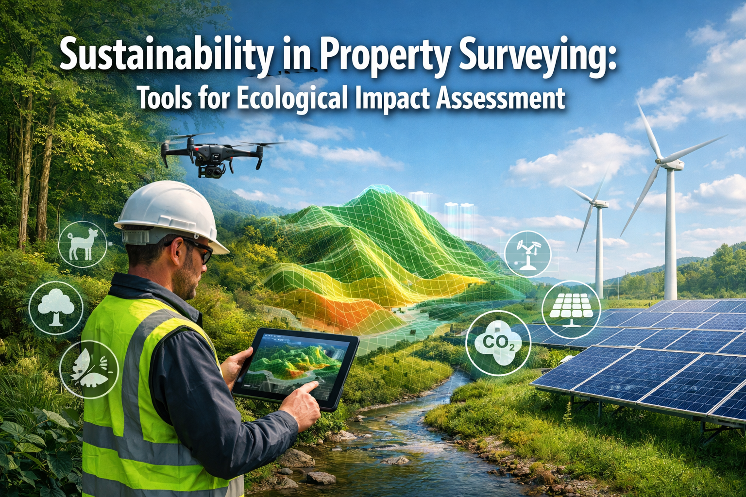
The property surveying profession stands at a critical crossroads in 2026. As climate change accelerates and biodiversity loss intensifies, the traditional role of surveyors has evolved dramatically. No longer limited to measuring boundaries and assessing structural integrity, today's chartered surveyors must navigate complex environmental regulations while deploying cutting-edge technology to forecast ecological impacts before development begins. Sustainability in Property Surveying: Tools for Ecological Impact Assessment has transformed from an optional consideration into a fundamental requirement, driven by regulatory mandates and market demand for responsible land use.
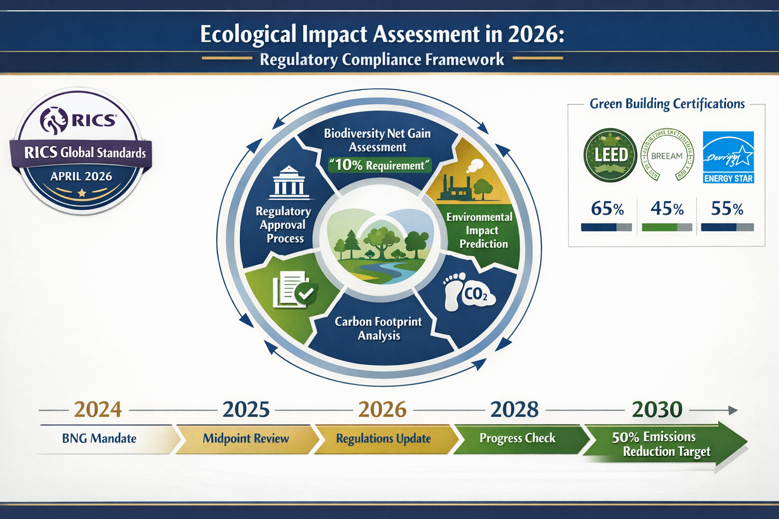
The landscape has shifted dramatically since the introduction of mandatory Biodiversity Net Gain (BNG) assessments in 2024, which require all eligible developments to demonstrate a 10% net gain in biodiversity.[5] Combined with the Royal Institution of Chartered Surveyors (RICS) updated global standard on ESG and sustainability that became effective April 30, 2026,[3] property professionals now operate within an increasingly stringent regulatory framework designed to protect ecosystems and communities. This evolution demands new competencies, sophisticated tools, and a fundamentally different approach to property assessment.
Key Takeaways
- 🌱 Mandatory biodiversity requirements: All eligible developments in 2026 must demonstrate a 10% net gain in biodiversity through comprehensive ecological impact assessments
- 📊 Technology-driven forecasting: Advanced tools including AI, 3D mapping, LiDAR, and BIM enable surveyors to capture environmental data and predict impacts before construction begins
- 📋 Regulatory compliance evolution: RICS global standards effective April 2026 mandate ESG and sustainability considerations in property valuations and assessments
- 🎯 Carbon reduction targets: The building sector must achieve approximately 50% reduction in direct CO₂ emissions by 2030, requiring precise measurement and management tools
- 💼 Market transformation: Over 90% of large real estate investors now align projects with green building standards, making sustainability expertise essential for surveying professionals
The Evolution of Environmental Responsibility in Property Surveying
From Traditional Measurement to Ecological Stewardship
Property surveying has undergone a remarkable transformation over the past decade. Historically focused on boundary disputes, structural assessments, and property valuations, the profession now encompasses comprehensive environmental stewardship. This shift reflects broader societal recognition that every development decision carries ecological consequences that extend far beyond property lines.
The traditional building survey has expanded to include environmental considerations that were barely acknowledged a generation ago. Today's surveyors must understand soil contamination, habitat connectivity, carbon sequestration potential, and biodiversity value alongside conventional structural and legal concerns.
Regulatory Drivers Reshaping the Profession
Property development in 2026 operates within increasingly stringent environmental regulations designed to protect ecosystems and people.[2][6] These frameworks have fundamentally altered surveying practice:
Biodiversity Net Gain (BNG) became legally mandatory for new developments in 2024 and remains a cornerstone requirement in 2026. This policy requires developers to demonstrate that habitat for wildlife is in a measurably better state after development than before, with a minimum 10% net gain.[5] For surveyors, this means conducting detailed ecological assessments using standardized metrics and biodiversity calculation tools.
The RICS updated global standard on ESG and sustainability, effective April 30, 2026, aligns with mandatory requirements in the RICS Valuation Global Standards and International Valuation Standards.[3] This represents a significant shift from voluntary best practices to mandatory compliance, requiring surveyors to integrate sustainability considerations into every valuation and assessment.
The Business Case for Sustainable Surveying
Beyond regulatory compliance, market forces are driving sustainability integration. Over 2,500 companies globally (including many real estate firms) have set Science-Based Targets validated to meet Paris Agreement goals, with real estate commonly targeting 45-50% operational emissions reductions by 2030 and nearly 100% by 2050.[4]
GRESB participation has climbed sharply: in 2023, over 1,200 property companies and funds (with approximately $5 trillion in assets) reported into the GRESB assessment, representing a 20%+ increase from just a few years prior.[4] This demonstrates that sustainability performance has become a competitive differentiator and investment criterion.
Perhaps most tellingly, 90% of large real estate investors and developers now align projects with green building standards, integrating sustainability criteria into design and operations through frameworks like LEED, BREEAM, and ENERGY STAR.[4] Surveyors who cannot demonstrate competence in ecological impact assessment increasingly find themselves excluded from major projects.
Sustainability in Property Surveying: Tools for Ecological Impact Assessment – Core Technologies
Advanced Mapping and Spatial Analysis Tools
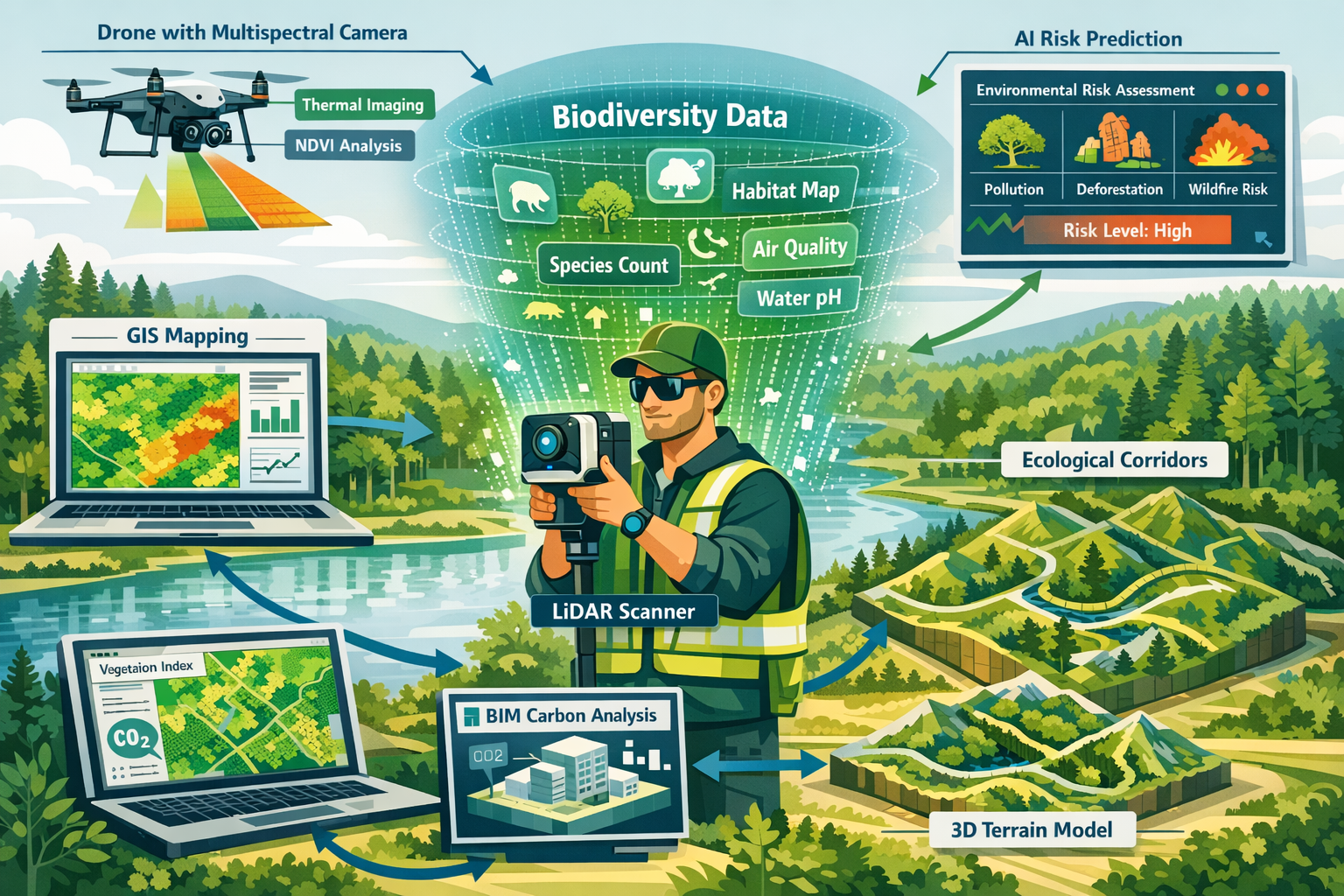
Modern ecological impact assessment relies on sophisticated spatial technologies that enable surveyors to capture, analyze, and visualize environmental data with unprecedented precision.
3D mapping and visualization tools have become more accessible and affordable, allowing surveyors to create detailed, interactive maps and models for improved client communication and decision-making.[2] These tools transform abstract ecological data into comprehensible visual representations that stakeholders can understand and act upon.
Geographic Information Systems (GIS) serve as the foundation for spatial environmental analysis. GIS platforms enable surveyors to:
- Layer multiple environmental datasets (habitat maps, species distributions, soil types, hydrology)
- Identify ecological corridors and connectivity pathways
- Analyze spatial relationships between development sites and protected areas
- Model habitat fragmentation impacts
- Track temporal changes in land cover and vegetation
LiDAR (Light Detection and Ranging) technology provides highly accurate topographic data essential for understanding landscape characteristics. LiDAR applications in ecological surveying include:
- Generating detailed digital elevation models
- Mapping vegetation structure and canopy height
- Identifying microtopographic features that support biodiversity
- Assessing flood risk and water flow patterns
- Detecting archaeological features that may have ecological significance
Drone Technology and Remote Sensing
Unmanned Aerial Vehicles (UAVs) or drones have revolutionized ecological data collection, offering cost-effective access to aerial perspectives that were previously prohibitively expensive.
Multispectral and hyperspectral imaging mounted on drones captures data beyond the visible spectrum, revealing vegetation health, species composition, and environmental stress indicators invisible to the naked eye. This technology enables surveyors to:
- Assess vegetation vigor using normalized difference vegetation index (NDVI)
- Identify invasive species with distinctive spectral signatures
- Map habitat types across large areas efficiently
- Monitor seasonal changes in ecological conditions
- Detect environmental contamination affecting plant health
Thermal imaging from drones identifies temperature variations that indicate water sources, animal activity, and microclimate conditions critical to biodiversity. When conducting boundary surveys or site assessments, thermal data adds an environmental dimension to traditional measurements.
Building Information Modeling (BIM) for Sustainability
Building Information Modeling (BIM) has evolved from a design coordination tool into a powerful sustainability assessment platform. BIM now allows teams to calculate embodied carbon in designs and identify reduction opportunities, with firms increasingly setting embodied carbon reduction targets per square foot.[4]
BIM applications in ecological impact assessment include:
- Embodied carbon calculation: Quantifying the carbon footprint of materials and construction processes
- Energy performance modeling: Predicting operational emissions and identifying efficiency improvements
- Material optimization: Selecting lower-impact alternatives while maintaining structural integrity
- Lifecycle assessment: Evaluating environmental impacts across the entire building lifecycle
- Circular economy planning: Designing for deconstruction and material reuse
Integration between BIM and environmental data creates comprehensive digital twins that model both built and natural environments, enabling surveyors to forecast how developments will interact with ecosystems.
Artificial Intelligence and Machine Learning
AI and machine learning technologies are being deployed to predict property risks including floods, landslides, and other environmental hazards.[6] These predictive capabilities represent a fundamental advancement in how surveyors approach ecological impact assessment.
Machine learning applications include:
Predictive risk modeling: AI algorithms analyze historical data, climate projections, and site characteristics to forecast environmental risks with increasing accuracy. This enables proactive mitigation rather than reactive response.
Automated species identification: Computer vision systems trained on extensive image databases can identify plant and animal species from photographs, accelerating biodiversity surveys and reducing reliance on scarce ecological expertise.
Pattern recognition: Machine learning identifies subtle patterns in environmental data that human analysts might miss, revealing ecological relationships and potential impacts.
Optimization algorithms: AI can evaluate thousands of development scenarios to identify configurations that minimize ecological impact while meeting project objectives.
Sustainability in Property Surveying: Tools for Ecological Impact Assessment – Methodologies and Frameworks
Biodiversity Net Gain Assessment Process
The BNG assessment methodology provides a structured approach to quantifying biodiversity value and calculating net gain. Understanding this framework is essential for surveyors working on development projects in 2026.
The Biodiversity Metric (currently version 4.0 in 2026) provides a standardized calculation method that assigns biodiversity units to different habitat types based on:
- Distinctiveness: How rare or ecologically valuable the habitat type is
- Condition: The current quality of the habitat
- Strategic significance: Location within ecological networks or priority areas
- Extent: The area of habitat
The BNG process follows these key stages:
- Baseline assessment: Survey existing habitats and calculate pre-development biodiversity units
- Impact assessment: Determine biodiversity units lost due to development
- Mitigation design: Plan on-site habitat creation and enhancement
- Off-site compensation: Identify additional habitat improvements if on-site measures are insufficient
- Net gain calculation: Demonstrate minimum 10% increase in biodiversity units
- Monitoring and management: Implement 30-year habitat management plans
Surveyors must document this entire process with precision, as valuation factors increasingly include biodiversity performance and regulatory compliance.
Ecological Impact Assessment (EcIA) Framework
Beyond BNG requirements, comprehensive Ecological Impact Assessment provides a broader evaluation of development effects on ecosystems.[9] The EcIA framework follows established guidelines from professional bodies and includes:
Desk study and data gathering: Reviewing existing environmental records, protected species databases, habitat maps, and historical land use information.
Field surveys: Conducting seasonal surveys appropriate to the site's ecological features, which may include:
- Phase 1 habitat surveys
- Protected species surveys (bats, great crested newts, badgers, etc.)
- Breeding bird surveys
- Invertebrate assessments
- Botanical surveys
Impact prediction: Evaluating potential effects on identified ecological features, considering:
- Direct habitat loss
- Habitat fragmentation
- Disturbance to species
- Hydrological changes
- Air quality impacts
- Light and noise pollution
Mitigation hierarchy: Applying the sequential approach of avoid, minimize, restore, and offset impacts.
Residual impact assessment: Determining significance of remaining impacts after mitigation measures.
Carbon Footprint Analysis Tools
The International Energy Agency estimates the building sector must reduce direct CO₂ emissions by approximately 50% by 2030 to stay on a 1.5°C climate pathway, equivalent to roughly 6% annual reduction.[4] Meeting these targets requires precise measurement and management tools.
Carbon assessment tools used in property surveying include:
Whole Life Carbon Assessment: Evaluating both embodied carbon (materials and construction) and operational carbon (energy use) across the building lifecycle.
Carbon calculators: Specialized software that quantifies emissions from:
- Material extraction and manufacturing
- Transportation to site
- Construction processes
- Operational energy consumption
- Maintenance and refurbishment
- End-of-life demolition and disposal
Benchmarking databases: Comparing project carbon intensity against industry standards and best practices to identify improvement opportunities.
Scenario modeling: Testing alternative design options to optimize carbon performance while maintaining functionality and cost-effectiveness.
ESG Reporting and Compliance Frameworks
ESG automation and advanced carbon tracking technology enable property owners to measure, manage, and improve ESG performance with unprecedented speed and precision.[4] Surveyors increasingly provide data that feeds into comprehensive ESG reporting systems.
Key frameworks include:
GRESB (Global Real Estate Sustainability Benchmark): The industry-standard ESG assessment for real estate portfolios, covering environmental performance, social responsibility, and governance practices.
TCFD (Task Force on Climate-related Financial Disclosures): Reporting framework for climate risks and opportunities affecting property assets.
SASB (Sustainability Accounting Standards Board): Industry-specific sustainability disclosure standards for real estate.
Green building certifications: LEED, BREEAM, ENERGY STAR, and other rating systems that require detailed environmental performance data from surveyors.
When conducting property valuations, surveyors must now consider how ESG performance affects asset value, rental income potential, and investment attractiveness.
Practical Implementation: Integrating Ecological Assessment into Surveying Practice
Pre-Survey Planning and Scoping
Effective ecological impact assessment begins long before fieldwork commences. Proper scoping ensures that surveys capture relevant data efficiently and comply with regulatory requirements.
Desktop study essentials include:
- Reviewing local planning policies and environmental designations
- Consulting statutory nature conservation body databases
- Examining aerial photography and historical maps
- Identifying nearby protected sites (SSSIs, SACs, SPAs, etc.)
- Researching previous ecological surveys in the area
- Understanding seasonal constraints for species surveys
Stakeholder engagement at the scoping stage helps identify concerns and opportunities early. This includes consulting with:
- Local planning authorities
- Environmental regulators
- Conservation organizations
- Community groups
- Adjacent landowners
Field Survey Techniques and Best Practices
Modern ecological surveying combines traditional naturalist skills with advanced technology. Surveyors must either develop ecological competencies or collaborate with qualified ecologists.
Habitat assessment forms the foundation of most ecological surveys. The UK Phase 1 Habitat Survey methodology (or equivalent systems in other jurisdictions) provides a standardized classification system. Surveyors record:
- Habitat types and extent
- Vegetation composition and structure
- Indicators of habitat quality
- Potential for protected species
- Connectivity to surrounding habitats
Species surveys require specialist knowledge and appropriate licensing for protected species. Common survey types include:
- Bat surveys: Using acoustic detectors and emergence surveys to identify roost locations and foraging areas
- Reptile surveys: Deploying artificial refugia and conducting systematic searches
- Amphibian surveys: Pond surveys for great crested newts and other species
- Bird surveys: Breeding bird census, wintering bird surveys, and nest searches
- Invertebrate surveys: Targeted surveys for notable species
Technology integration enhances survey efficiency and data quality:
- GPS-enabled tablets for real-time mapping
- Acoustic recording devices for automated species monitoring
- Camera traps for nocturnal and elusive species
- Environmental DNA (eDNA) sampling for aquatic species detection
- Drone surveys for inaccessible areas
Data Analysis and Impact Prediction
Transforming raw field data into actionable ecological impact assessments requires systematic analysis and professional judgment.
Spatial analysis using GIS platforms enables surveyors to:
- Map habitat distribution and quality
- Calculate areas of different habitat types
- Identify ecological corridors and stepping stones
- Model species dispersal and movement patterns
- Assess cumulative impacts from multiple developments
Impact significance assessment evaluates effects against established criteria:
- Geographic scale: International, national, regional, local, or site-level importance
- Magnitude: Total loss, major loss, minor loss, or no loss
- Duration: Permanent, long-term, medium-term, or short-term
- Reversibility: Whether impacts can be reversed through restoration
Predictive modeling uses baseline data to forecast how ecosystems will respond to development. Advanced models incorporate:
- Population viability analysis for key species
- Habitat suitability modeling
- Connectivity analysis
- Climate change interactions
- Cumulative effects from other developments
Mitigation Design and Enhancement Opportunities
The mitigation hierarchy guides the design of measures to address predicted impacts:
Avoidance represents the most effective approach—designing developments to avoid sensitive areas entirely. This might involve:
- Adjusting site layouts to preserve key habitats
- Timing construction to avoid sensitive breeding seasons
- Routing access roads away from wildlife corridors
Minimization reduces unavoidable impacts through careful design:
- Reducing development footprint
- Installing wildlife-friendly fencing
- Using directional lighting to minimize disturbance
- Implementing pollution prevention measures
Restoration repairs degraded habitats on-site:
- Enhancing retained habitats through management
- Removing invasive species
- Restoring natural hydrology
- Creating buffer zones around sensitive features
Compensation addresses residual impacts through habitat creation:
- Creating new habitats equivalent to those lost
- Enhancing habitats elsewhere to achieve net gain
- Contributing to strategic habitat networks
- Participating in biodiversity offset schemes
When working on building surveys, surveyors should identify opportunities for ecological enhancement even in urban contexts—green roofs, bat boxes, swift bricks, and native landscaping can contribute to biodiversity net gain.
Challenges and Solutions in Ecological Impact Assessment
Data Quality and Availability Issues
Challenge: Ecological data is often incomplete, outdated, or inconsistent across jurisdictions. Species records may be biased toward well-studied areas, creating false negatives for biodiversity value.
Solutions:
- Invest in comprehensive baseline surveys rather than relying solely on desk studies
- Use predictive habitat modeling to identify likely species presence
- Engage citizen science initiatives to supplement professional surveys
- Establish data-sharing agreements with local ecological groups
- Implement standardized data collection protocols across projects
Seasonal Survey Constraints
Challenge: Many ecological surveys must be conducted during specific seasons when species are detectable. This can delay development timelines and create scheduling conflicts.
Solutions:
- Plan surveys well in advance, anticipating seasonal requirements
- Conduct preliminary assessments to identify likely survey needs
- Use eDNA and other advanced detection methods that may have wider seasonal windows
- Consider precautionary approaches when surveys cannot be completed
- Integrate survey timing into project planning from inception
Balancing Development Needs with Ecological Protection
Challenge: Developers and conservationists may have conflicting objectives, creating tension in the assessment process.
Solutions:
- Engage stakeholders early to understand concerns and constraints
- Use objective, evidence-based assessment methods
- Explore creative design solutions that meet multiple objectives
- Quantify ecosystem services to demonstrate value of protection
- Identify win-win opportunities where development can enhance degraded sites
Competency and Training Gaps
Challenge: Traditional surveying education may not include sufficient ecological training, while ecologists may lack surveying expertise.
Solutions:
- Pursue continuing professional development in ecological assessment
- Establish partnerships between surveyors and ecological consultants
- Advocate for integrated training programs that combine disciplines
- Obtain relevant professional memberships (RICS, CIEEM, etc.)
- Participate in industry working groups developing best practices
Cost and Resource Constraints
Challenge: Comprehensive ecological assessment can be expensive, particularly for smaller developments with tight budgets.
Solutions:
- Develop proportionate approaches scaled to project size and sensitivity
- Use technology to improve efficiency (drones, automated monitoring)
- Establish framework agreements with ecological consultants for consistent pricing
- Educate clients on the value proposition of early ecological assessment
- Highlight regulatory risks and delays from inadequate assessment
Future Trends in Sustainability and Property Surveying
Emerging Technologies on the Horizon
The pace of technological advancement continues to accelerate, with several emerging tools poised to transform ecological impact assessment:
Artificial Intelligence advancement: Machine learning algorithms will become increasingly sophisticated at predicting ecological impacts, potentially identifying subtle effects that current methods miss. AI-powered platforms may eventually provide real-time impact assessment during design development.[6]
Satellite monitoring integration: Improved satellite imagery resolution and frequency will enable continuous monitoring of ecological conditions across entire regions, providing context for site-specific assessments and tracking cumulative impacts.
Environmental DNA evolution: eDNA techniques will expand beyond aquatic environments to terrestrial applications, potentially revolutionizing species detection and reducing survey effort.
Digital twins for ecosystems: Comprehensive digital models that simulate ecosystem dynamics will enable surveyors to test development scenarios and predict long-term ecological trajectories with greater confidence.
Blockchain for biodiversity credits: Distributed ledger technology may facilitate transparent trading of biodiversity units, creating more efficient offset markets and ensuring accountability in net gain delivery.
Regulatory Evolution and Anticipated Changes
Environmental regulation continues to evolve in response to the biodiversity and climate crises:
Mandatory nature recovery: Governments are increasingly establishing legally binding nature recovery targets that will require demonstration of positive biodiversity outcomes across development portfolios, not just individual sites.
Climate adaptation requirements: Future regulations will likely mandate climate resilience assessment, requiring surveyors to evaluate how developments will perform under future climate scenarios and contribute to landscape-scale adaptation.
Circular economy mandates: Policies promoting material reuse and waste reduction will require surveyors to assess buildings for deconstruction potential and material recovery value.
Enhanced ESG disclosure: Regulatory requirements for ESG reporting will expand, requiring more detailed and standardized environmental performance data from property assessments.
Integration with Broader Sustainability Frameworks
Ecological impact assessment will increasingly integrate with other sustainability considerations:
Nature-based solutions: Recognition of ecosystems as infrastructure will drive integration of green infrastructure into development design, with surveyors assessing multifunctional benefits including flood management, cooling, air quality improvement, and biodiversity.
Natural capital accounting: Monetary valuation of ecosystem services will become more sophisticated and widely adopted, enabling cost-benefit analyses that properly account for environmental impacts.
One Health approaches: Understanding the connections between ecosystem health, animal health, and human health will influence how surveyors assess development impacts, particularly regarding disease risk and wellbeing benefits.
Social equity considerations: Environmental justice concerns will require surveyors to evaluate how ecological impacts and benefits are distributed across communities, ensuring disadvantaged populations are not disproportionately affected.
Professional Development and Career Opportunities
The sustainability transformation creates significant opportunities for surveyors who develop relevant expertise:
Specialist roles: Demand is growing for surveyors with dual competencies in traditional surveying and ecological assessment, commanding premium fees for integrated services.
Advisory positions: Experienced practitioners are increasingly sought for strategic advisory roles, helping organizations develop sustainability strategies and navigate regulatory complexity.
Technology specialists: Surveyors who master emerging technologies (AI, BIM, advanced GIS) will be positioned to lead innovation in the profession.
Training and education: Opportunities exist for experienced practitioners to contribute to professional development programs, raising competency across the industry.
Surveyors pursuing these opportunities should consider relevant certifications, such as RICS Certified Sustainability Professional, and engage with professional bodies developing guidance on ecological assessment.
Case Studies: Sustainability in Property Surveying in Action
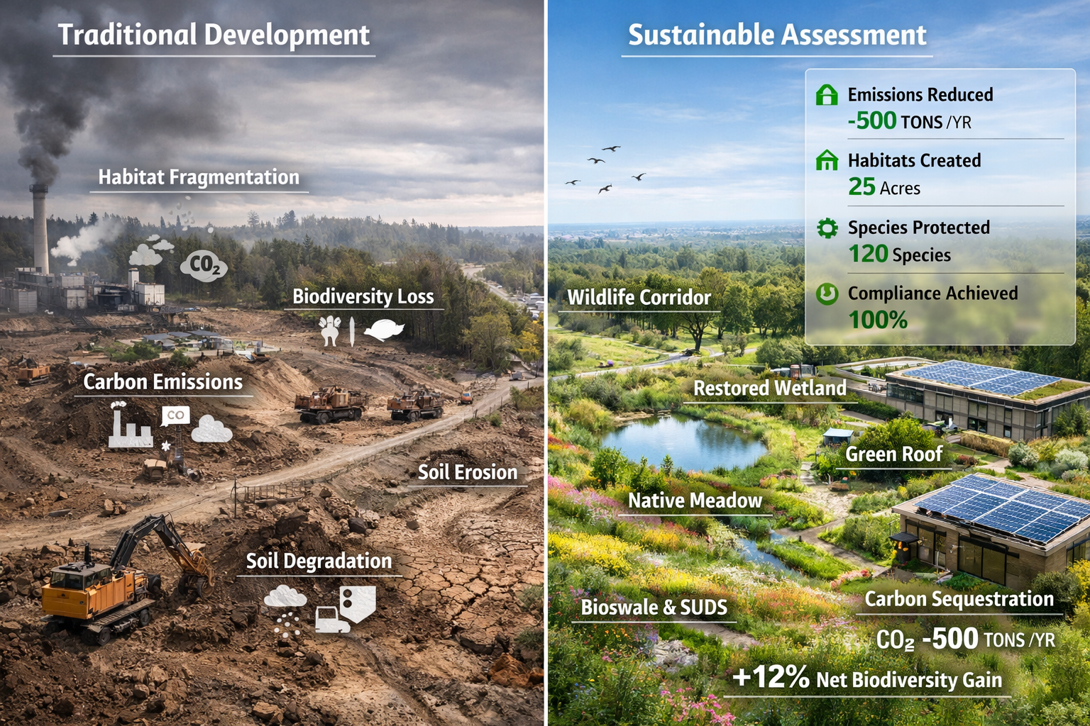
Urban Regeneration with Biodiversity Enhancement
A major mixed-use development in London transformed a brownfield site while achieving 15% biodiversity net gain—exceeding the 10% minimum requirement. The surveying team employed comprehensive ecological assessment tools:
- Baseline assessment: Drone surveys with multispectral imaging identified valuable brownfield habitats supporting rare invertebrates
- 3D modeling: BIM integration allowed designers to visualize green infrastructure and optimize habitat placement
- AI-powered optimization: Machine learning algorithms tested thousands of layout configurations to maximize both development density and ecological value
- Monitoring framework: IoT sensors and camera traps track species colonization and habitat establishment
The project demonstrated that urban development and biodiversity enhancement are not mutually exclusive when supported by sophisticated assessment tools and creative design.
Rural Development with Landscape-Scale Connectivity
A residential development in Surrey navigated complex ecological constraints by adopting a landscape-scale approach to impact assessment:
- GIS connectivity analysis: Spatial modeling identified critical wildlife corridors connecting ancient woodland fragments
- Collaborative design: Early engagement with ecologists and landscape architects integrated green corridors into the masterplan
- Offset strategy: On-site habitat creation was supplemented with strategic off-site enhancement strengthening the broader ecological network
- Long-term stewardship: A management company was established to maintain ecological features in perpetuity
This case illustrates how comprehensive spatial analysis tools enable developments to contribute positively to ecological networks rather than fragmenting them.
Commercial Property Retrofit for Carbon Neutrality
A commercial property owner commissioned a comprehensive sustainability assessment of their portfolio to achieve carbon neutrality by 2030:
- Whole life carbon assessment: BIM-based analysis quantified embodied and operational carbon across all buildings
- Energy modeling: Dynamic thermal simulation identified cost-effective retrofit measures
- Nature-based solutions: Surveyors identified opportunities for green roofs, rain gardens, and urban greening that provide carbon sequestration alongside other benefits
- ESG reporting integration: Assessment data fed directly into GRESB reporting, improving the portfolio's sustainability rating
This demonstrates how commercial property valuations increasingly depend on comprehensive sustainability performance data.
Conclusion: Embracing the Sustainable Future of Property Surveying
The integration of Sustainability in Property Surveying: Tools for Ecological Impact Assessment represents far more than regulatory compliance—it signifies a fundamental evolution in professional identity and responsibility. Surveyors in 2026 operate at the critical intersection of built and natural environments, wielding powerful technologies that enable prediction and prevention of ecological harm while identifying opportunities for environmental enhancement.
The tools discussed throughout this article—from AI-powered risk prediction to biodiversity metric calculators, from LiDAR mapping to BIM carbon analysis—provide unprecedented capability to understand and manage environmental impacts. Yet technology alone cannot drive the necessary transformation. Professional judgment, ecological literacy, and commitment to sustainability principles remain essential.
The regulatory landscape will continue evolving, with requirements likely becoming more stringent as biodiversity and climate crises intensify. Surveyors who proactively develop competencies in ecological impact assessment position themselves not merely to survive this transition but to thrive as essential contributors to sustainable development.
Actionable Next Steps for Surveying Professionals
Immediate actions (within 1-3 months):
- ✅ Review the RICS updated global standard on ESG and sustainability effective April 2026
- ✅ Assess current competency gaps in ecological assessment and sustainability
- ✅ Identify technology platforms relevant to your practice area (GIS, BIM, carbon calculators)
- ✅ Establish relationships with ecological consultants for collaborative projects
- ✅ Join relevant professional networks focused on sustainability in surveying
Short-term development (3-12 months):
- 📚 Complete continuing professional development courses in biodiversity net gain, carbon assessment, or ESG reporting
- 🔧 Implement at least one new technology tool in your practice
- 🤝 Collaborate on a project requiring comprehensive ecological impact assessment
- 📊 Develop standardized processes for integrating sustainability into your survey workflows
- 💡 Share knowledge with colleagues through presentations or articles
Long-term positioning (1-3 years):
- 🎓 Pursue advanced certifications in sustainability (RICS Certified Sustainability Professional, etc.)
- 🏆 Develop specialist expertise in a niche area (biodiversity net gain, embodied carbon, nature-based solutions)
- 📈 Build case studies demonstrating sustainability outcomes from your projects
- 🌍 Contribute to professional guidance development through industry working groups
- 🚀 Position your practice as a leader in sustainable property surveying
The transition to sustainable property surveying is not optional—it is the defining professional evolution of this generation. Those who embrace this transformation, invest in relevant competencies, and deploy appropriate tools will find themselves at the forefront of an industry reimagining its relationship with the natural world. The question is not whether sustainability will reshape property surveying, but whether individual practitioners will lead or follow this inevitable change.
For surveyors committed to excellence in 2026 and beyond, ecological impact assessment represents both professional obligation and opportunity. By mastering the tools and methodologies discussed in this article, surveyors can ensure that every property assessment contributes to a more sustainable, biodiverse, and resilient built environment.
References
[1] Navigating The Future Sustainable Land Surveying Techniques – https://envstudies.uw.edu/capstone/navigating-the-future-sustainable-land-surveying-techniques/
[2] Future Land Surveying 2026 – https://haller-blanchard.com/future-land-surveying-2026/
[3] Rics Publishes Updated Global Standard Esg Sustainability Commercial Property Valuation – https://www.rics.org/news-insights/rics-publishes-updated-global-standard-esg-sustainability-commercial-property-valuation
[4] Top 5 Esg Trends In Real Estate – https://rhino.energy/blog/top-5-esg-trends-in-real-estate
[5] Ecological Assessment Examples – https://gaiacompany.io/ecological-assessment-examples/
[6] Predicting Property Risks With Ai And Machine Learning Floods Landslides And Beyond In 2026 – https://nottinghillsurveyors.com/blog/predicting-property-risks-with-ai-and-machine-learning-floods-landslides-and-beyond-in-2026
[7] Esg Sustainability Survey 2025 26 – https://ivsc.org/esg-sustainability-survey-2025-26/
[8] The State Of Sustainability And Real Estate 2025 Lessons And What S Next For 2026 – https://bregroup.com/news/the-state-of-sustainability-and-real-estate-2025-lessons-and-what-s-next-for-2026
[9] Ecological Impact Assessment – https://arbtech.co.uk/ecology-surveys/ecological-impact-assessment/