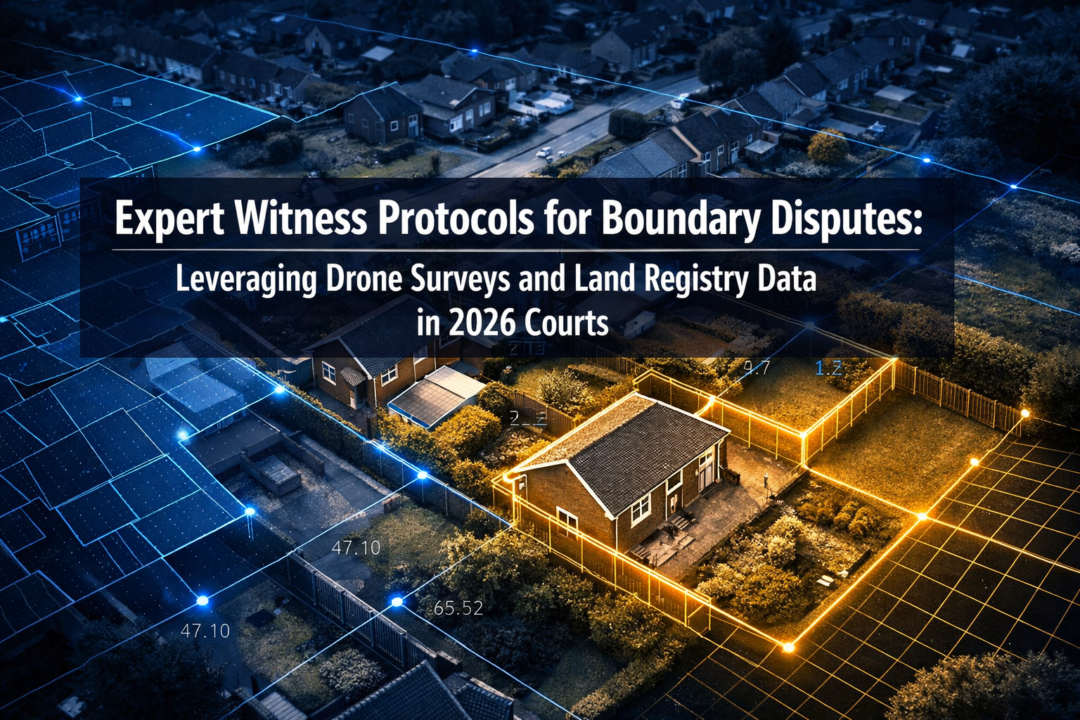
Boundary disputes now account for one of the fastest-growing categories of civil litigation in England and Wales — with the number of neighbour boundary claims filed at county courts rising sharply alongside a post-pandemic surge in property development and garden extensions. In this environment, Expert Witness Protocols for Boundary Disputes: Leveraging Drone Surveys and Land Registry Data in 2026 Courts have never been more critical to understand. Surveyors who fail to meet the strict requirements of CPR Part 35 — the Civil Procedure Rules governing expert evidence — risk having their reports excluded entirely, leaving clients without the technical support their case demands.
This guide is written specifically for chartered surveyors, legal professionals, and property owners who need a clear, authoritative roadmap through the 2026 expert witness landscape.
Key Takeaways 📋
- CPR Part 35 compliance is non-negotiable: Expert witness reports must declare overriding duty to the court, not the client.
- Drone surveys now carry significant evidential weight when properly georeferenced and documented to court standards.
- Land Registry data is a foundational tool, but its limitations must be clearly disclosed in any expert report.
- Pre-action protocol compliance — including good-faith negotiation — is expected before boundary disputes reach litigation.
- Independence and transparency are the twin pillars of credible expert evidence in 2026 courts.
Understanding the Legal Framework: CPR Part 35 and the Boundary Disputes Protocol
Before a single drone takes flight or a Land Registry title plan is printed, an expert witness must fully understand the legal framework within which their evidence will be judged.
CPR Part 35: The Expert's Overriding Duty
Under Civil Procedure Rules Part 35, an expert witness owes their primary duty to the court, not to the party that instructed them. This is a fundamental principle that shapes every aspect of how a boundary survey report must be written, structured, and presented.
Key CPR Part 35 requirements include:
- A signed declaration of independence confirming the expert understands their overriding duty to the court
- A statement that the report contains the expert's genuine professional opinion
- Disclosure of any material facts that might undermine the expert's conclusions
- A clear statement of the facts and assumptions on which opinions are based
💬 "Experts must maintain unbiased analysis independent of client wishes or attorney influence — any perception of partiality can be fatal to the credibility of an expert report in court." [3]
Failure to comply with these requirements can result in the court refusing to admit the report as evidence — a devastating outcome for the instructing party.
The Pre-Action Protocol for Boundary Disputes
The Protocol for Disputes between Neighbours about the Location of their Boundary establishes a structured pre-action process that must be followed before litigation commences [1]. This protocol, supported by the Property Litigation Association, requires parties to:
- Exchange relevant information in a timely and transparent manner
- Understand the role of professional advisers, including surveyors and solicitors
- Explore Alternative Dispute Resolution (ADR) methods such as mediation
- Engage constructively in negotiation before escalating to court [1]
Courts take a dim view of parties who rush to litigation without genuine attempts at resolution. A surveyor's expert report should acknowledge this protocol and confirm whether pre-action steps were taken.
For property owners navigating these early stages, understanding boundary dispute resolution options is an essential first step before instructing an expert witness.
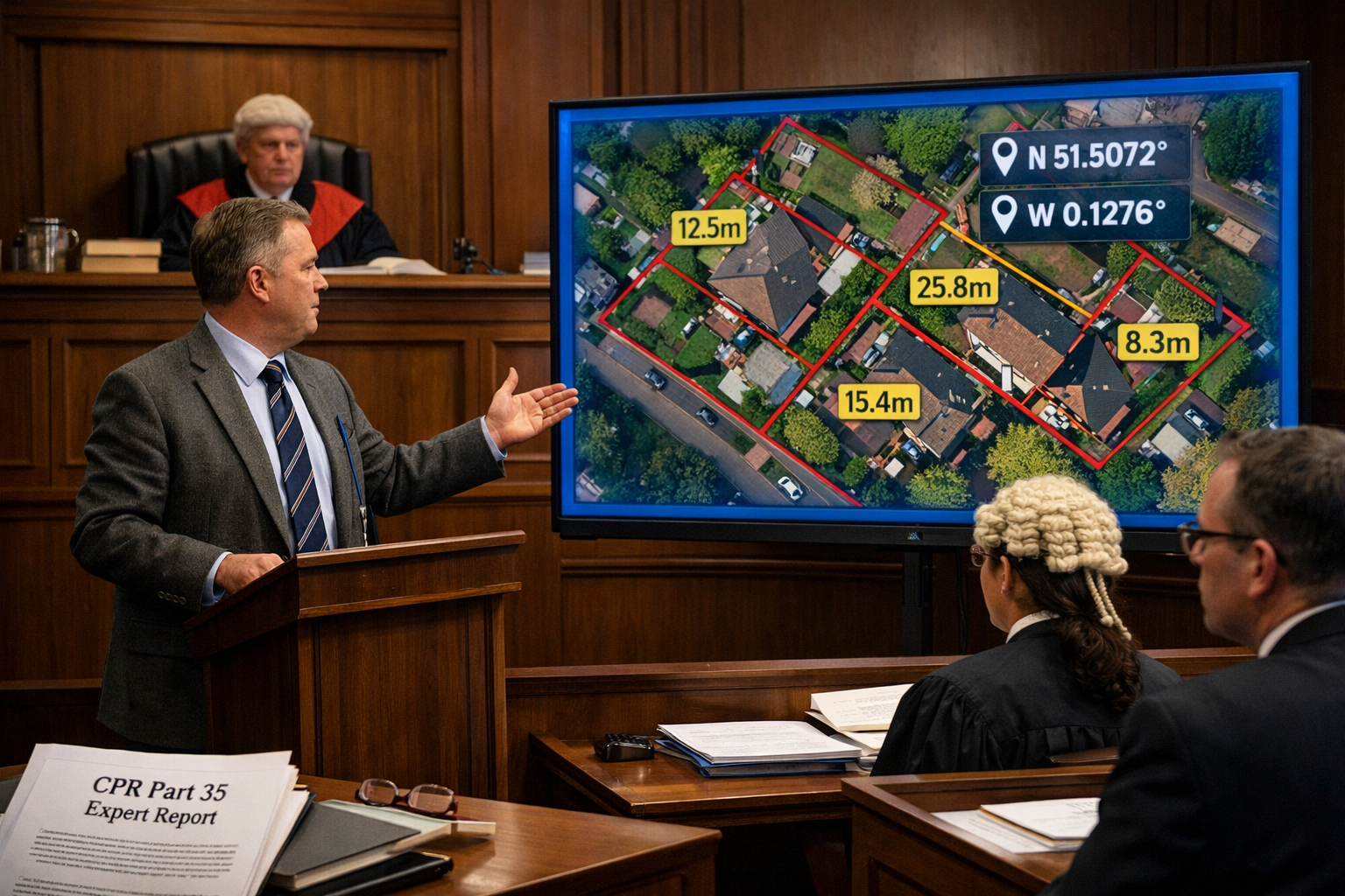
Drone Surveys as Courtroom Evidence: Standards, Accuracy, and Admissibility
The use of drone technology in boundary dispute litigation has matured significantly. In 2026, courts are increasingly familiar with — and receptive to — drone-derived evidence, provided it meets rigorous technical and procedural standards.
Why Drone Surveys Are Transforming Boundary Evidence
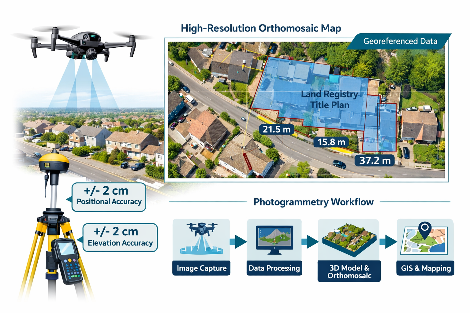
Traditional ground-based surveys, while still valid, have practical limitations: access restrictions, vegetation obstruction, and the inability to capture the full spatial context of a disputed boundary. Drone surveys — particularly those using photogrammetry and LiDAR — overcome many of these challenges.
Key advantages of drone survey evidence include:
| Feature | Traditional Survey | Drone Survey |
|---|---|---|
| Coverage area | Limited by ground access | Full aerial overview |
| Accuracy | ±5–10mm (total station) | ±2–5cm (RTK drone) |
| Visual context | Limited | Orthomosaic imagery |
| Historical comparison | Not applicable | Overlay with historic aerials |
| Court presentation | Technical drawings | Intuitive visual evidence |
For boundary disputes specifically, professional drone survey services can capture high-resolution orthomosaic images that show fence lines, wall positions, and encroachments with remarkable clarity.
Technical Standards for Drone Evidence in 2026 Courts
Not all drone footage is equal. Courts will scrutinise the methodology, equipment calibration, and data processing behind any drone-derived survey. An expert witness presenting drone evidence must be prepared to address:
- Ground Control Points (GCPs): Precisely measured reference points that anchor the drone imagery to real-world coordinates
- RTK/PPK GPS accuracy: Real-Time Kinematic or Post-Processed Kinematic GPS ensures sub-5cm positional accuracy
- Software validation: Photogrammetry software (e.g., Agisoft Metashape, Pix4D) must be documented and its outputs validated
- CAA compliance: All drone operations must comply with UK Civil Aviation Authority regulations, including operator registration and airspace authorisation
- Metadata preservation: EXIF data, flight logs, and processing reports must be retained as part of the evidence chain
🔑 Key point: A drone survey without documented GCPs, calibration records, and a clear methodology statement is unlikely to withstand cross-examination in court.
Presenting Drone Data Effectively
The most technically perfect drone survey can still fail in court if it is poorly presented. Expert witnesses should consider:
- Annotated orthomosaic overlays showing disputed boundary lines with measurements
- Side-by-side comparisons with historical aerial photographs to demonstrate change over time [1]
- 3D point cloud visualisations for complex terrain or structure disputes
- Scale-accurate plan drawings derived from the drone data, suitable for court bundles
For complex cases involving structural encroachments, a boundary survey from a qualified chartered surveyor should accompany drone evidence to provide the professional interpretation courts require.
Leveraging Land Registry Data: Opportunities and Critical Limitations
Land Registry data is often the starting point for any boundary dispute — but it is frequently misunderstood by both lay clients and, occasionally, less experienced experts.
What Land Registry Data Can (and Cannot) Tell You
HM Land Registry title plans are drawn from Ordnance Survey mapping at scales typically ranging from 1:1,250 to 1:2,500. This means that on a standard residential title plan, a line width of 1mm can represent 1.25 to 2.5 metres on the ground. This is a critical limitation that every expert witness must disclose clearly in their report [4].
What Land Registry data provides:
- ✅ General position of registered title boundaries
- ✅ Ownership extent relative to neighbouring titles
- ✅ Historical title plan comparisons (via archived editions)
- ✅ Easements, covenants, and registered rights
- ✅ Relationship to Ordnance Survey base mapping
What Land Registry data does NOT provide:
- ❌ Precise boundary measurements to millimetre accuracy
- ❌ The exact position of physical features (fences, walls, hedges)
- ❌ Resolution of the "general boundary rule" — the legal boundary vs. the physical boundary
- ❌ Confirmation of adverse possession claims
💬 "The general boundary rule means that Land Registry title plans show the general position of boundaries — they do not define the precise legal boundary line." [4]
Using Updated Land Registry Digital Tools in 2026
HM Land Registry has continued to expand its digital infrastructure. In 2026, expert witnesses can access:
- National Polygon Service: Machine-readable boundary polygon data for overlay with drone imagery
- Digital Registration Service: Updated title information with faster refresh cycles
- Historical title plan archive: Enabling comparison of boundary positions across decades
- INSPIRE Index Polygons: Open-data boundary polygons for cross-referencing
When overlaying Land Registry polygon data with drone-derived orthomosaics, experts can produce compelling visual evidence that shows precisely where physical features sit relative to registered title boundaries — a combination that courts find highly persuasive [5].
For cases involving party walls or shared boundaries, understanding party wall dispute procedures is equally important, as these often run parallel to boundary location disputes.
Structuring a CPR Part 35-Compliant Expert Report in 2026
The Anatomy of a Court-Ready Boundary Expert Report
A well-structured expert witness report for a boundary dispute should follow a clear, logical format. Below is the recommended structure for 2026 courts:
1. Expert's Details and Qualifications
- RICS membership and relevant specialisms
- Professional indemnity insurance confirmation
- Statement of experience in boundary disputes specifically
2. Instructions and Scope
- Clear statement of who instructed the expert and when
- The specific questions the expert was asked to address
- Documents and data provided for review
3. CPR Part 35 Declaration
- Signed statement of overriding duty to the court
- Confirmation of independence from client and legal team
4. Factual Background
- Property descriptions and title details
- History of the dispute as understood from documents
- Site visit details (dates, conditions, access)
5. Evidence Reviewed
- Land Registry title plans (with scale limitations noted)
- Historical maps, aerial photographs, and OS data [1]
- Drone survey methodology and outputs
- Witness statements reviewed (if applicable)
6. Expert Opinion
- Reasoned professional opinion on boundary location
- Acknowledgment of any uncertainty or alternative interpretations
- Areas of agreement with any opposing expert
7. Summary and Conclusions
- Concise answers to the questions posed in instructions
- Any caveats or conditions attached to opinions
8. Statement of Truth
Common Mistakes That Undermine Expert Reports
🚫 Avoid these pitfalls:
- Adopting the client's position without independent analysis
- Failing to disclose the scale limitations of Land Registry plans
- Presenting drone data without documented methodology
- Omitting reference to historical evidence that contradicts conclusions [1]
- Using technical jargon without plain-English explanations for the judge
- Failing to address the opposing expert's points in a joint statement
For cases where construction works have altered boundary features, a specific defect report may be needed to document physical changes to boundary structures.
The Joint Expert Statement: Narrowing Issues Before Trial
One of the most important — and often underestimated — stages of boundary dispute litigation is the joint expert statement (sometimes called a "Scott Schedule" or joint memorandum). Under CPR Part 35, courts routinely direct opposing experts to meet and produce a document that:
- Identifies points of agreement
- Identifies points of disagreement and the reasons for each
- Clarifies whether any disagreements relate to facts or professional opinion
This process can significantly reduce the scope of a trial. Experts who approach the joint statement process constructively — rather than defensively — demonstrate the independence and professionalism that courts expect [2].
🔑 Best practice: Prepare for the joint expert meeting by reviewing all evidence thoroughly and being genuinely open to updating opinions where the opposing expert raises valid points. Changing an opinion based on new information is a sign of professional integrity, not weakness.
For neighbours dealing with boundary issues that also involve construction or renovation works, understanding construction disputes resolution can provide additional context for the expert's role.
Historical Evidence and the Expert's Investigative Toolkit
Courts place significant weight on historical evidence in boundary disputes. An expert witness who has thoroughly investigated the historical record — and can present it clearly — will carry far greater authority than one who relies solely on current title plans [1].
Building the Historical Evidence Base
Key historical sources for boundary expert witnesses include:
- Tithe maps (pre-1850): Often the earliest reliable large-scale mapping of rural boundaries
- Ordnance Survey historical editions: Available from 1840s onwards, showing boundary features at various points in time
- Aerial photographs: Historic aerial photography from the 1940s onwards can show original fence and hedge positions
- Conveyance documents: Pre-registration title deeds often contain more precise boundary descriptions than modern title plans
- Planning records: Historic planning applications may include site plans showing boundary positions
- Witness statements: Evidence from long-standing neighbours or former owners about physical boundary positions [1]
The combination of historical documentary evidence with modern drone survey data creates a powerful evidential narrative — showing both where boundaries were historically and where physical features currently sit.
For properties where boundary issues intersect with leasehold or freehold title questions, consulting resources on buying the freehold can help clarify the ownership context.
Conclusion: Actionable Steps for Expert Witnesses in 2026 Boundary Disputes
The convergence of advanced drone technology, improved Land Registry digital tools, and increasingly sophisticated court expectations has raised the bar for expert witness protocols in boundary disputes. Surveyors and legal professionals operating in this space in 2026 must be prepared to meet that bar — or risk their evidence being dismissed.
Actionable Next Steps ✅
-
Audit your CPR Part 35 compliance: Review your standard report template against the current CPR requirements and update your declaration of independence.
-
Invest in RTK drone capability: If drone surveys are part of your practice, ensure your equipment and methodology meet the accuracy and documentation standards courts expect.
-
Disclose Land Registry limitations proactively: Always include a clear explanation of the general boundary rule and title plan scale limitations in every report.
-
Build a historical evidence toolkit: Develop relationships with mapping archives and conveyancing solicitors to access historical documents efficiently.
-
Approach joint expert meetings constructively: Prepare thoroughly, remain genuinely open-minded, and focus on narrowing issues — not winning arguments.
-
Engage early with the pre-action protocol: Advise clients to follow the boundary disputes protocol carefully before litigation, including genuine exploration of ADR [1].
For property owners and professionals seeking expert boundary survey support in London and the surrounding areas, working with experienced boundary surveyors who understand both the technical and legal dimensions of 2026 court requirements is the most effective way to build a strong, admissible case.
The stakes in boundary disputes are high — both financially and personally. Expert witnesses who combine technical excellence with rigorous procedural compliance will continue to be the decisive factor in how these cases are resolved.
References
[1] Legal Guide To Boundary Disputes And Land Disputes – https://www.summitlawllp.co.uk/legal-guide-to-boundary-disputes-and-land-disputes/
[2] Expert Witness Cross Border – https://handle.ae/private-capital/dispute-resolution/cross-border-litigation-arbitration/expert-witness-cross-border/
[3] Expert Witness Essentials For 2026 Boundary Disputes Strengthening Cases In A Recovering Property Market – https://nottinghillsurveyors.com/blog/expert-witness-essentials-for-2026-boundary-disputes-strengthening-cases-in-a-recovering-property-market
[4] Boundary Dispute Resolution – https://www.apexsurveyor.com/boundary-dispute-resolution
[5] Land Surveying Expert Witness – https://seakexperts.com/specialties/land-surveying-expert-witness