Over 175,000 boundary disputes are estimated to arise in England and Wales every year, yet the majority of property owners arrive at court armed with little more than a Land Registry title plan — a document specifically designed not to define legal boundaries with precision. The gap between what people expect title plans to prove and what courts actually require is where cases are won and lost. Understanding the role of Expert Witness Surveyors in Boundary and Access Disputes: What Evidence Courts Expect Beyond Title Plans is essential for anyone facing litigation over land ownership or access rights in 2026.
Key Takeaways 📋
- Title plans are indicative, not definitive — courts routinely look beyond them to physical features, occupation history, and measured survey data.
- Expert witness surveyors must comply with CPR Part 35 and owe their primary duty to the court, not the instructing party.
- Physical evidence — fences, walls, hedges, and worn paths — often carries more weight than paper records alone.
- A well-structured expert report combines measured surveys, photographic schedules, historical mapping, and reasoned interpretation.
- Instructing a qualified, independent surveyor early can prevent disputes from escalating to costly litigation.
Why Title Plans Alone Rarely Decide Boundary Cases
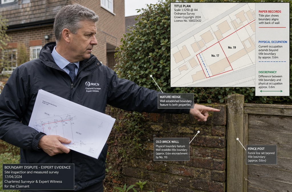
The Land Registry title plan is drawn on an Ordnance Survey base map at a scale of 1:1250 (urban) or 1:2500 (rural). At these scales, a line just 1mm wide on paper can represent 1.25 to 2.5 metres on the ground. The Land Registration Act 2002 and its accompanying rules make clear that the general boundary rule applies: the exact line of the legal boundary is not fixed by registration.
💬 "The filed plan shows the general position of the boundary, not the precise legal boundary." — HM Land Registry Practice Guide 40
This is not a flaw in the system — it is a deliberate design choice. The registry was never intended to resolve centimetre-level disputes. Courts have consistently held, from Neilson v Poole (1969) through to more recent cases, that extrinsic evidence is both admissible and necessary when the paper title is ambiguous.
What this means in practice:
| Evidence Type | Typical Weight in Court | Notes |
|---|---|---|
| Title plan alone | Low | Indicative only; general boundary rule applies |
| Conveyance plan + description | Medium–High | Pre-2002 deeds often more precise |
| Measured survey by expert | High | Objective, reproducible data |
| Physical occupation evidence | High | Long-standing features carry significant weight |
| Historical aerial photography | Medium–High | Shows boundary features over time |
| Witness testimony | Variable | Corroborated by physical evidence is stronger |
For property owners in London and the surrounding area, understanding how boundary disputes and party wall matters intersect is a vital first step before instructing any professional.
The Legal Framework Governing Expert Witness Surveyors in Boundary and Access Disputes
CPR Part 35: The Expert's Overriding Duty
Civil Procedure Rules (CPR) Part 35 governs expert evidence in England and Wales. Every expert witness — including chartered surveyors — must understand that their primary duty is to the court, not to the party paying their fees. This is non-negotiable and courts take it seriously.
Key obligations under CPR Part 35 include:
- ✅ Providing an opinion that is independent and unbiased
- ✅ Stating the facts and assumptions on which the opinion is based
- ✅ Acknowledging where matters fall outside the expert's expertise
- ✅ Signing a declaration of truth and a statement of compliance
- ✅ Updating the court if the expert's opinion changes
An expert who is seen to be acting as an advocate for their client — rather than an independent professional — risks having their evidence disregarded entirely. Judges have not hesitated to make adverse costs orders where expert evidence has been partisan.
The RICS Expert Witness Practice Statement
The Royal Institution of Chartered Surveyors (RICS) publishes a practice statement on acting as an expert witness. RICS members who accept expert witness instructions must follow it. The statement reinforces CPR Part 35 obligations and adds professional conduct requirements. Surveyors who breach it face disciplinary action from RICS, in addition to any court sanctions.
What Evidence Courts Expect Beyond Title Plans: The Surveyor's Toolkit
This is the heart of what Expert Witness Surveyors in Boundary and Access Disputes: What Evidence Courts Expect Beyond Title Plans must deliver. A credible expert report goes far beyond reproducing the title plan. It builds a layered evidential picture from multiple independent sources.
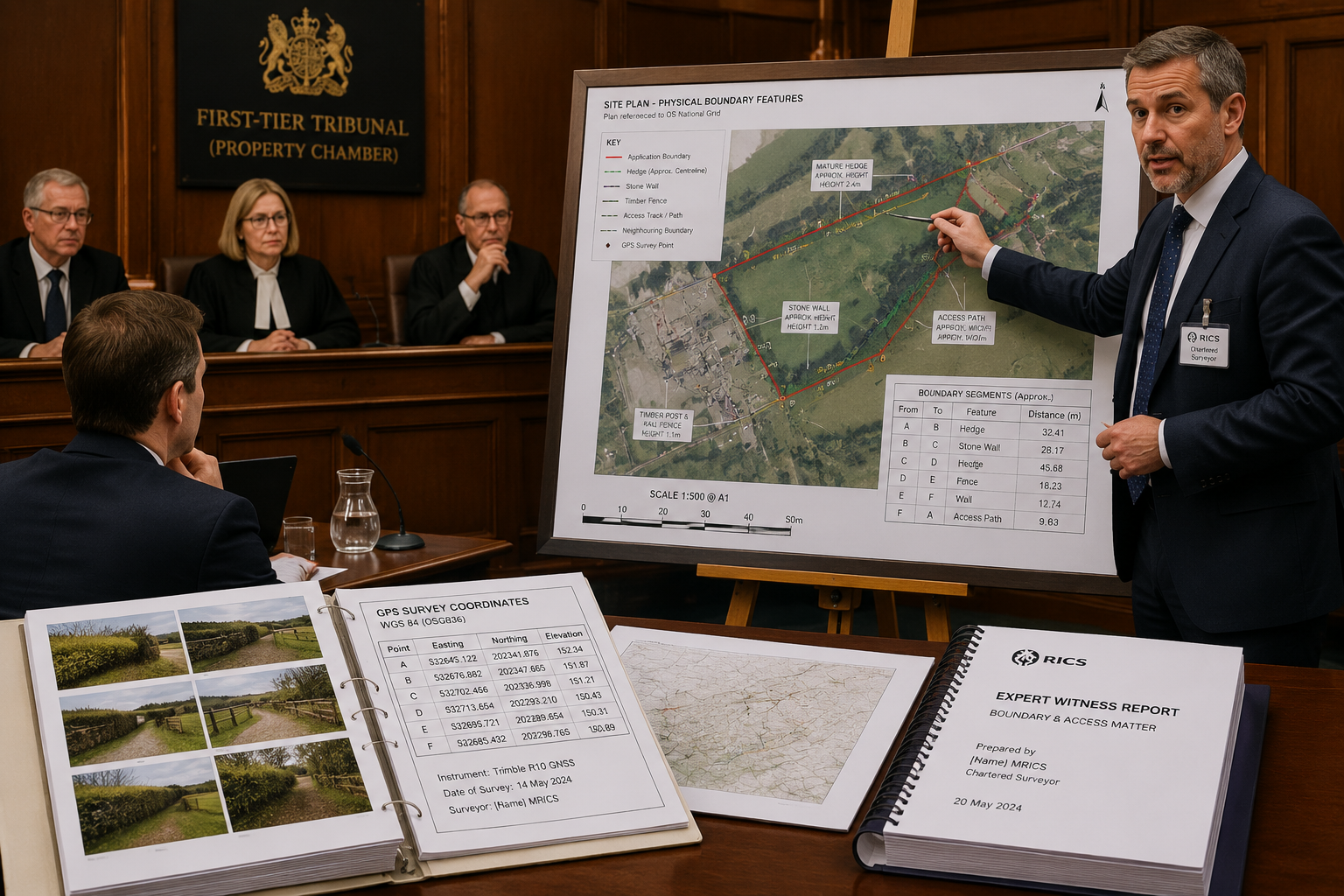
1. 📐 Measured Survey Data
A precise measured survey is the foundation of any expert report. Using total stations, GPS/GNSS equipment, or laser scanning technology, the surveyor plots:
- The position of all physical boundary features (walls, fences, hedges, ditches)
- Their relationship to the OS base mapping used in the title plan
- Any discrepancies between the paper boundary and the physical occupation line
- Measurements to fixed reference points (building corners, road edges) that cannot be disputed
Coordinates should be expressed in the National Grid reference system so that measurements are reproducible by any other surveyor. Courts expect this level of rigour.
2. 🗺️ Historical Mapping and Aerial Photography
Boundary features do not appear overnight. A skilled expert traces their history through:
- Ordnance Survey historical maps (available from the 1840s onwards)
- Tithe maps and apportionment schedules (pre-1850 rural properties)
- Historical aerial photographs — the National Collection held by Historic England contains imagery from the 1940s onwards
- Google Earth historical imagery (useful for the past 20 years)
- Planning application drawings submitted by previous owners
These sources can show when a fence was erected, whether a hedge has always marked the boundary, or whether an access path has been in continuous use — all critical facts in adverse possession and prescriptive easement claims.
3. 📸 Photographic Evidence Schedule
Photographs must be systematic, not selective. A professional photographic schedule includes:
- Location plans showing where each photograph was taken
- Date and time stamps (ideally from camera metadata)
- Images of all boundary features, not just those favourable to the instructing party
- Scale references (ranging rods, measuring tapes) in relevant shots
- Before-and-after photographs where works have altered features
Courts are alert to cherry-picked photography. A complete, objective schedule strengthens credibility.
4. 🏚️ Physical Occupation and Use Evidence
In many boundary disputes, the key question is not where the paper boundary lies but where the physical boundary has been treated as lying over many years. Evidence of occupation includes:
- The position and condition of existing structures (walls, outbuildings, gates)
- Maintenance patterns — who has cut the hedge, repaired the fence, cleared the ditch
- Planting and cultivation — garden beds, paving, and landscaping that reflect assumed ownership
- Access routes — worn paths, dropped kerbs, gate positions
For access disputes specifically — rights of way, easements, and prescriptive rights — the surveyor maps the physical route used, its width, surface condition, and relationship to any claimed legal right. This work often overlaps with party wall and boundary dispute resolution where neighbouring works have altered access arrangements.
5. 📜 Conveyance Plans and Deed Interpretation
Pre-registration conveyance plans are frequently more precise than title plans. The expert surveyor:
- Obtains all available conveyances from the Land Registry and solicitors' files
- Plots the metes and bounds descriptions onto a scaled drawing
- Identifies any conflicts or ambiguities between successive conveyances
- Applies the legal principle that the conveyance description governs where plan and text conflict
This is technical work requiring both surveying skill and an understanding of conveyancing language — without crossing into legal argument, which remains the domain of counsel.
Structuring the Expert Witness Report: What Courts Want to See
A court-ready expert report follows a clear structure. Judges and tribunal members read many such reports; clarity and logical organisation matter enormously.
Recommended report structure:
- Introduction and instructions — who instructed the expert, on what terms, and what questions were asked
- Expert's qualifications and experience — relevant RICS membership, years of practice, previous court experience
- Documents and materials considered — a complete list; courts distrust experts who have not reviewed all available material
- Site inspection record — date, weather, who was present, access arrangements
- Factual findings — measured data, physical observations, historical mapping analysis
- Opinion — clearly separated from facts; reasoned, balanced, and acknowledging uncertainty where it exists
- Summary of conclusions
- Statement of truth and CPR Part 35 declaration
💬 The expert's opinion section must be clearly distinguished from factual observations. Mixing the two is a common weakness that undermines reports in cross-examination.
Common Pitfalls That Undermine Expert Evidence
Even experienced surveyors can fall into traps that weaken their reports. The most frequent problems include:
- ❌ Advocacy creep — gradually shifting from objective analysis to arguing the client's case
- ❌ Selective evidence — ignoring physical features or historical maps that cut against the instructing party's position
- ❌ Imprecise measurements — using scaled measurements from the title plan rather than independent field survey data
- ❌ Overstepping expertise — offering opinions on legal title or the construction of legal documents (that is counsel's role)
- ❌ Failure to consider alternative interpretations — a strong report acknowledges and addresses competing explanations
- ❌ Inadequate site inspection — visiting only once, in poor conditions, or without measuring equipment
Surveyors working across London and the South East — whether instructed in West London, Central London, or South East London — encounter a wide variety of boundary types, from Victorian terrace rear gardens to suburban plots with complex historical subdivision. Local knowledge of typical construction periods and boundary conventions adds genuine value to an expert report.
Access Disputes: Additional Evidence the Court Will Scrutinise
Access disputes — whether over claimed rights of way, easements, or vehicular access — require additional layers of evidence beyond those needed for pure boundary cases.
Prescriptive Easements and Long Use
To establish a prescriptive right of way, a claimant must show 20 years of continuous, open, and unchallenged use. The surveyor's role is to provide objective evidence of:
- The physical route — its width, surface, and condition over time (historical photography is invaluable here)
- Structures that imply use — gates, stiles, dropped kerbs, worn surfaces
- The relationship between the claimed route and the title plan — does the physical path correspond to any paper right?
Ransom Strips and Access to Highway
A particularly contentious category involves ransom strips — narrow strips of land between a property and the public highway that are owned by a third party. The surveyor must:
- Precisely measure the strip's width and position
- Establish ownership from title registers
- Map the physical access arrangements actually in use
For those dealing with complex access and boundary issues in areas such as North London or Surrey, engaging a chartered surveyor with specific experience in access disputes is strongly advisable before proceedings begin.
The Joint Expert and Single Joint Expert Appointments
Courts increasingly encourage parties to instruct a Single Joint Expert (SJE) — one surveyor appointed by both sides — rather than each party retaining their own expert. This reduces costs and avoids the spectacle of two surveyors giving diametrically opposed opinions.
Where separate experts are instructed, the court will typically order a without-prejudice meeting between them to produce a joint statement identifying:
- Points of agreement
- Points of disagreement and the reasons for each
This joint statement is often more influential than the individual reports. Surveyors who approach the meeting constructively — genuinely trying to narrow issues — serve their clients better than those who treat it as another adversarial encounter.
Early Instruction: Why It Matters
One of the most consistent findings in boundary litigation is that early instruction of a qualified surveyor — before positions harden and litigation costs escalate — produces better outcomes. An early measured survey can:
- Clarify whether a genuine dispute exists or whether the difference is within measurement tolerance
- Identify the strongest and weakest aspects of each party's position
- Support mediation or negotiation with objective data rather than assertion
- Preserve evidence — physical features can be altered, removed, or deteriorate over time
For those uncertain about what type of survey they need at the outset of a boundary concern, a preliminary consultation with a chartered surveyor can clarify the appropriate scope of work before any formal instruction is made.
Conclusion: Actionable Next Steps
Boundary and access disputes are rarely resolved by title plans alone. Courts in 2026 expect Expert Witness Surveyors in Boundary and Access Disputes: What Evidence Courts Expect Beyond Title Plans to deliver a comprehensive, independently verified evidential picture — one that combines measured survey data, historical mapping, photographic schedules, and objective interpretation of physical occupation.
Here is what to do if you are facing a boundary or access dispute:
- Do not alter or remove any physical boundary features — these are evidence.
- Gather all available title documents, including pre-registration conveyances if possible.
- Instruct a RICS-qualified chartered surveyor early — before solicitors issue proceedings.
- Request a measured survey of the disputed area, not just a desktop review of the title plan.
- Ask your surveyor about CPR Part 35 compliance — if they are unfamiliar with it, find someone who is.
- Consider mediation — a jointly instructed expert can often resolve disputes at a fraction of litigation costs.
The difference between a boundary dispute that settles quickly and one that consumes years of time and tens of thousands of pounds in legal fees often comes down to the quality of the surveying evidence assembled at the outset. Investing in a thorough, court-ready expert report is rarely the most expensive decision in a boundary dispute — but failing to do so frequently is.