Global insured losses from natural catastrophes exceeded $137 billion in 2023 alone — and the gap between insured and actual economic losses continues to widen. The core problem is not a shortage of data but a failure to turn that data into precise, property-level predictions fast enough to matter. That is exactly the gap that predicting property risks with AI and machine learning: floods, landslides, and beyond in 2026 is closing, reshaping how insurers, developers, surveyors, and homeowners understand exposure before disaster strikes.
Key Takeaways
- AI and machine learning models now predict flood risk four to six times more accurately than traditional hydrological models alone.
- Landslide susceptibility mapping using AI identifies critical geological variables that rule-based models routinely miss.
- Property-level risk scoring — integrating climate projections, survey data, and satellite imagery — is transforming insurance underwriting and real estate due diligence.
- Automation benefits extend beyond speed: ML models reduce human bias, flag previously invisible hazard combinations, and update continuously as new data arrives.
- Surveyors and developers who integrate AI-driven hazard intelligence into structural assessments gain a significant competitive and compliance advantage in 2026.
Why Traditional Hazard Modelling Is No Longer Enough
For decades, flood plain mapping relied on static 100-year return-period models built from limited gauge data. Landslide susceptibility was assessed through manual geological surveys that could take months. These methods were not wrong — they were simply too slow, too coarse, and too expensive to scale.
Three structural shifts have changed the landscape:
- Data volume: Satellite constellations, IoT sensors, drone surveys, and street-level imagery now generate continuous, high-resolution geospatial data at a scale that was unimaginable ten years ago.
- Computational power: Cloud-based GPU clusters allow complex ensemble models to run in minutes rather than weeks.
- Algorithmic maturity: Deep learning, gradient boosting, and large language model (LLM) frameworks can now ingest heterogeneous data sources — soil composition, rainfall intensity, building footprints, elevation — and produce interpretable risk scores.
The result is a new generation of hazard intelligence tools that operate at the individual property level, not just the postcode or flood zone level. For anyone commissioning a structural survey in London or a subsidence survey, understanding how AI layers onto traditional survey findings is increasingly relevant.
The Shift from Zone-Based to Property-Level Risk
Traditional flood zone designations paint with a broad brush. A property on the "safe" side of a flood zone boundary may still face significant risk from surface water drainage failures, while a property technically inside a flood zone may have mitigation features that dramatically reduce its actual exposure.
The Flood-LLM framework addresses this directly. By integrating multi-source urban data — including building characteristics, drainage infrastructure, and neighbourhood spatial factors — it produces flood risk assessments at the individual property level rather than relying on zone-wide averages [8]. Similarly, the FloodGenome model applies interpretable machine learning to National Flood Insurance Program data, revealing the underlying factors that drive urban flood risk predisposition and enabling more nuanced integrated urban design strategies [7].
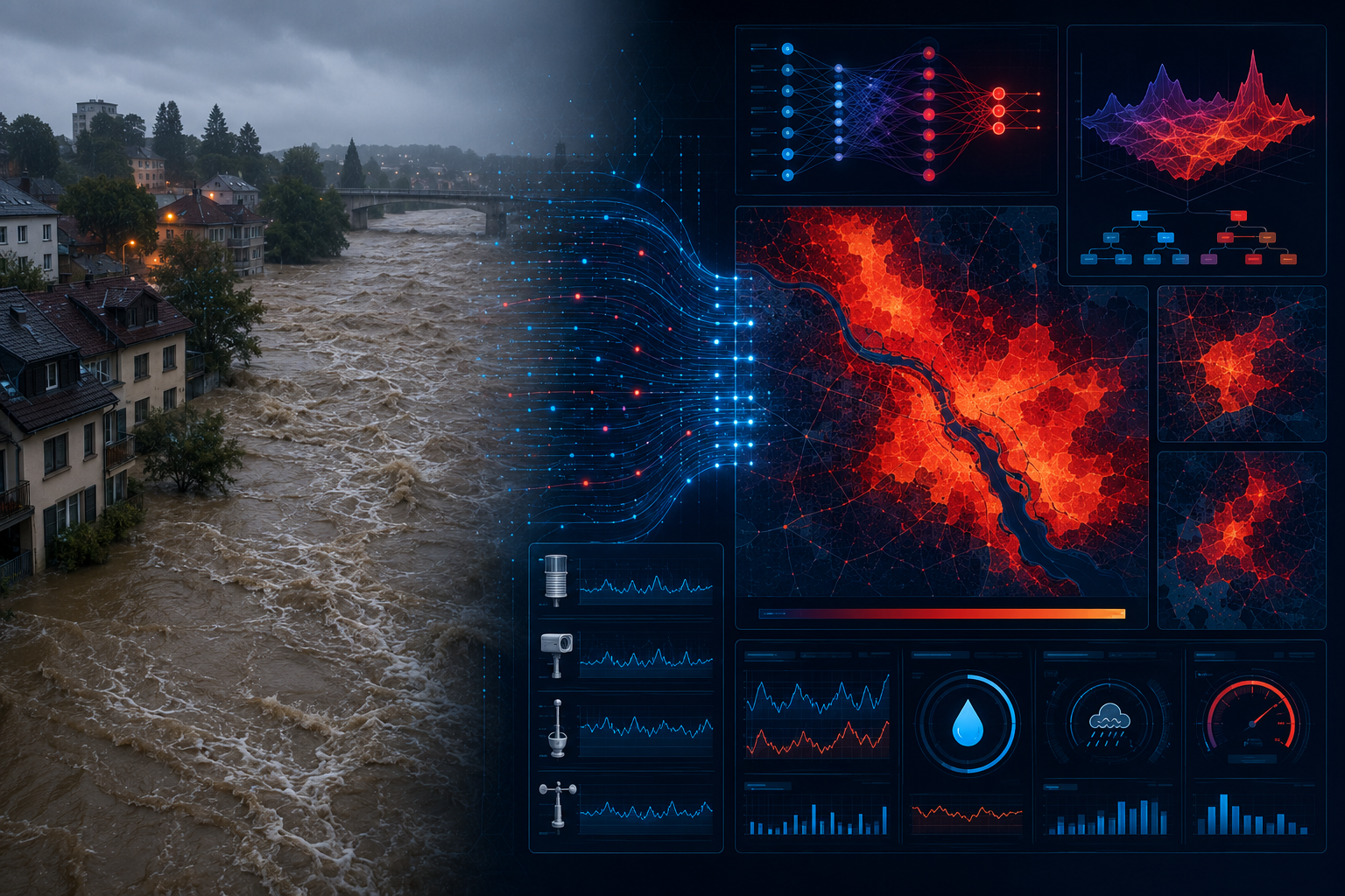
How AI Models Are Transforming Flood and Landslide Prediction
Flood Prediction: From Sixfold Accuracy Gains to Real-Time Alerts
A landmark study published in September 2025 demonstrated that integrating AI with the U.S. National Water Model improved flood prediction accuracy by four to six times compared to the model running without AI enhancement [3]. This is not a marginal improvement — it represents the difference between a 24-hour warning and a 4-hour warning for downstream communities.
The mechanism behind this gain is the AI component's ability to learn from historical discrepancies between model outputs and observed flood events. Where the physics-based model systematically under- or over-predicts because of unmodelled local factors — urban heat islands, informal drainage modifications, subsurface geology — the machine learning layer corrects for those biases in near real-time.
SkyTL's multi-hazard platform takes this further by combining sensor data, AI, and physics models to deliver real-time intelligence across floods, hurricanes, and wildfires simultaneously [2]. This kind of multi-hazard awareness is particularly valuable for commercial property portfolios where a single extreme weather event can trigger cascading risks across multiple asset types.
In April 2026, the ASFPM Foundation released a comprehensive report titled "Harnessing AI for Flood Risk Management: Integrating People, Data, and Action," drawing on insights from nearly 90 experts. The report emphasises that responsible AI deployment in flood risk management requires transparency and technical defensibility — not just predictive accuracy [1]. This is a critical point: a model that produces accurate predictions but cannot explain its reasoning will face regulatory and legal challenges in underwriting and planning contexts.
"Transparency and technical defensibility are not optional features of AI flood risk tools — they are prerequisites for regulatory acceptance and public trust."
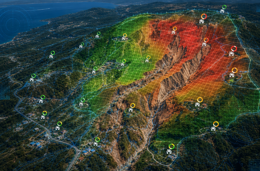
Landslide Susceptibility: AI Finds the Variables Humans Miss
Landslide prediction presents a different challenge. Unlike floods, which follow water flow physics, landslides involve complex interactions between slope angle, soil saturation, vegetation cover, seismic activity, and human land use changes. No single variable reliably predicts failure — it is the combination and threshold effects that matter.
In June 2023, UCLA geologists published research demonstrating that an AI-based method could predict landslides more accurately by identifying the critical variable combinations that contribute to slope failure [5]. The model's ability to detect non-linear interactions between geological and meteorological variables — interactions that rule-based models cannot capture — represents a qualitative leap in predictive capability.
A complementary study applying machine learning to multi-hazard mapping in southwestern Saudi Arabia found that the Random Forest model performed best for flood and gully erosion prediction, while the FDA (Flexible Discriminant Analysis) model was most accurate for landslide susceptibility mapping [9]. This finding matters for practitioners: no single algorithm dominates across all hazard types, and robust risk assessment platforms should deploy multiple model architectures.
ClimateCheck operationalises these insights for property buyers, using AI and government datasets to generate instant, explainable climate risk scores — covering floods, wildfires, and landslides — for any U.S. address [6]. The "explainable" component is key: homebuyers and their advisors need to understand why a property scores high risk, not just that it does.
Street-View AI and Elevation Data: A New Frontier
One of the most promising developments in 2026 is the use of AI to extract building-specific elevation data from street-view imagery at regional scale. Research published in April 2026 demonstrated that AI analysis of street-view images, combined with machine learning imputation techniques, can generate first-floor elevation data for individual buildings without requiring expensive LiDAR surveys [10].
This matters enormously for flood risk assessment. First-floor elevation relative to base flood elevation is one of the strongest predictors of flood damage. Historically, collecting this data at scale was cost-prohibitive. AI-driven street-view analysis changes that equation, enabling property-level flood risk scoring across entire cities at a fraction of the traditional cost.
Automation Benefits for Insurers, Developers, and Surveyors

Transforming Insurance Underwriting
ATTOM's AI-powered Property Risk Analytics platform illustrates how the insurance industry is integrating these capabilities. By combining climate projections, natural hazard indices, and mortgage performance data, the platform supports advanced machine learning applications for underwriting and risk assessment [4]. Insurers can now price flood and landslide risk at the individual property level, reducing adverse selection and improving portfolio management.
The automation benefits are substantial:
| Traditional Underwriting | AI-Enhanced Underwriting |
|---|---|
| Zone-based flood classification | Property-level flood probability score |
| Manual geological survey review | Automated slope stability index |
| Static annual risk assessment | Continuous model updates with new data |
| Single-hazard focus | Multi-hazard correlation analysis |
| Weeks to process new data | Near real-time data integration |
For commercial property portfolios, this shift is particularly significant. A commercial property surveyor in London advising on acquisition due diligence can now access AI-generated risk scores that integrate climate trajectory data alongside current hazard exposure — a capability that was simply not available at scale three years ago.
Implications for Property Valuation
AI-driven hazard intelligence is beginning to reshape property valuation methodology. A property's climate risk profile — its flood return period, landslide susceptibility score, wildfire proximity index — is increasingly treated as a material valuation factor rather than a footnote.
For RICS-registered valuers and those producing valuation reports in London, the question is no longer whether to incorporate climate risk data but how to do so in a way that is methodologically defensible. AI-generated risk scores need to be interpreted alongside physical survey findings, not treated as a replacement for them.
This is particularly relevant for retrospective valuations where historical flood or landslide events may have affected value at a specific date. Machine learning models trained on historical event data can help reconstruct the risk profile of a property at a past point in time with greater precision than was previously possible.
Benefits for Developers and Planning Teams
For property developers, AI hazard prediction tools offer three core advantages:
- Site selection: Rapid screening of potential development sites against multi-hazard risk profiles before committing to detailed surveys.
- Design optimisation: Understanding how specific design choices — floor levels, drainage systems, foundation type — affect a property's modelled risk score.
- Planning evidence: AI-generated risk assessments increasingly support planning applications in flood-sensitive areas, providing quantitative evidence that complements traditional Flood Risk Assessments.
Developers working in areas with complex ground conditions should also consider how AI hazard intelligence integrates with findings from dilapidation surveys and specific defect reports, particularly where existing structures show signs of movement or water ingress that may indicate underlying hazard exposure.
The Role of Survey Data in Training ML Models
A point that deserves emphasis: AI models are only as good as the data they are trained on. Physical survey data — soil bore logs, structural condition assessments, drainage surveys, elevation measurements — is foundational training material for the next generation of hazard prediction models.
This creates a virtuous cycle. Better surveys produce better training data, which produces more accurate models, which in turn help surveyors identify which properties warrant more detailed investigation. Surveyors who understand how their data feeds into ML pipelines are better positioned to collect the variables that matter most for model performance.
For properties where ground movement or water penetration is already a concern, a residential structural engineer assessment provides the kind of detailed physical data that AI models cannot yet generate from remote sensing alone. Human expertise and machine intelligence are complementary, not competitive.
Challenges, Limitations, and the Path Forward
Data Quality and Bias
ML models trained predominantly on data from well-monitored regions may perform poorly in areas with sparse historical records. This is a known limitation in both flood and landslide prediction: the regions most vulnerable to hazards are often the least well-instrumented.
Addressing this requires active investment in sensor networks, open data sharing between government agencies, and model architectures that can perform reliably under data scarcity — a challenge the research community is actively working on in 2026.
Regulatory and Liability Questions
As AI-generated risk scores begin to influence insurance pricing, lending decisions, and planning approvals, questions of accountability become urgent. If a model incorrectly classifies a property as low-risk and a flood subsequently occurs, who bears liability? The ASFPM Foundation's April 2026 report specifically addresses this, calling for transparency standards and technical defensibility requirements for AI tools used in flood risk management [1].
Interpretability vs. Accuracy Trade-offs
The most accurate models — deep neural networks with hundreds of layers — are often the least interpretable. For regulatory and legal contexts, interpretable models like gradient boosting with SHAP (SHapley Additive exPlanations) values are frequently preferred even if they sacrifice some predictive accuracy. The FloodGenome model's emphasis on interpretable machine learning reflects this practical reality [7].
Conclusion
Predicting property risks with AI and machine learning: floods, landslides, and beyond in 2026 is no longer a research aspiration — it is an operational reality reshaping insurance, real estate, and built environment professions. The convergence of high-resolution geospatial data, mature ML algorithms, and cloud computing has made property-level hazard intelligence both technically feasible and commercially viable.
Actionable next steps for professionals:
- Insurers and underwriters: Evaluate AI-powered property risk analytics platforms that offer explainable outputs and integrate climate trajectory data alongside current hazard indices.
- Property valuers: Develop a working understanding of AI risk scores and how to interpret them alongside physical survey findings; consider climate risk a material valuation factor.
- Developers and planning teams: Use AI multi-hazard screening tools early in site selection to avoid costly late-stage discoveries.
- Surveyors: Recognise that detailed physical survey data is foundational training material for ML models; collect and document variables with precision.
- Homebuyers and property owners: Request AI-generated climate risk scores for any property under consideration and ask how those scores were derived.
The properties that will hold their value and remain insurable through the climate challenges ahead are those whose risk profiles are understood early, managed proactively, and communicated transparently. AI and machine learning are the most powerful tools available in 2026 to make that happen.
References
[1] Asfpm Foundation Releases Report On Harnessing Ai For Flood Risk Management – https://www.floods.org/news-views/asfpm-updates/asfpm-foundation-releases-report-on-harnessing-ai-for-flood-risk-management/?utm_source=openai
[2] skytl – https://www.skytl.com/?utm_source=openai
[3] Ai Boosts National Weather Model Flood Prediction Accuracy Sixfold – https://news.agu.org/press-release/ai-boosts-national-weather-model-flood-prediction-accuracy-sixfold/?utm_source=openai
[4] Property Risk Analytics – https://www.attomdata.com/solutions/ai-powered/property-risk-analytics/?utm_source=openai
[5] Artificial Intelligence Can Predict Landslides – https://newsroom.ucla.edu/releases/artificial-intelligence-can-predict-landslides?utm_source=openai
[6] Climate Risk Scoring – https://devpost.com/software/climate-risk-scoring?utm_source=openai
[7] arxiv – https://arxiv.org/abs/2403.10625?utm_source=openai
[8] mdpi – https://www.mdpi.com/2071-1050/18/6/2957?utm_source=openai
[9] S1464343x22003405 – https://www.sciencedirect.com/science/article/pii/S1464343X22003405?utm_source=openai
[10] arxiv – https://arxiv.org/abs/2604.01153?utm_source=openai