By 2026, the average large-scale crop farm in the United States uses at least four distinct digital surveying technologies simultaneously — a reality that would have seemed far-fetched just a decade ago. Precision Farming: How Surveying Technologies are Transforming Agriculture in 2026 is not a future concept; it is the operational standard reshaping how land is managed, inputs are applied, and yields are maximized across millions of acres worldwide. From centimeter-accurate GPS guidance to unmanned aerial vehicles (UAVs) mapping crop stress in real time, the convergence of surveying science and agricultural practice is delivering measurable returns for farmers and land professionals alike.
Key Takeaways
- Real-Time Kinematic (RTK) GPS and high-accuracy GNSS systems now deliver centimeter-level field positioning, enabling automated steering and precise variable-rate input application.
- UAVs equipped with multispectral cameras provide rapid, high-resolution aerial surveys that identify crop stress, soil variation, and irrigation inefficiencies faster than any ground-based method.
- Geographic Information Systems (GIS) transform raw survey data into actionable field maps, allowing farmers to make zone-specific management decisions that reduce waste and boost yields.
- Adoption of precision agriculture technologies correlates strongly with farm size, but declining hardware costs are making these tools increasingly accessible to mid-scale operations.
- Integrating AI, IoT sensors, and robotics with core surveying technologies represents the next frontier, promising further reductions in input costs and environmental impact.
The Surveying Technologies Driving Precision Farming in 2026
RTK-GPS and High-Accuracy GNSS Positioning
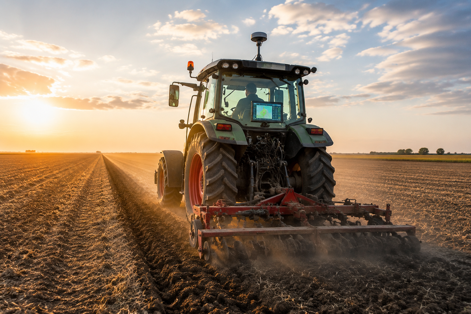
At the foundation of modern precision farming lies positioning technology. Standard GPS accuracy of several meters is insufficient for operations where a few centimeters can mean the difference between a seed placed correctly and one that is wasted. Real-Time Kinematic (RTK) GPS solves this by using a fixed base station and a rover unit to correct signal errors in real time, achieving positioning accuracy of 1 to 2 centimeters [1].
This level of accuracy supports automated steering systems, often called autosteering or autoguidance, that keep tractors and implements on precisely defined paths without constant operator input. The practical benefits are significant:
- Reduced overlap between passes, cutting seed, fertilizer, and chemical use
- Reduced operator fatigue during long field operations
- Consistent row spacing that improves canopy development and harvest efficiency
- Night operations that extend the productive window during critical planting or harvesting periods
High-accuracy GNSS networks, such as those offered by commercial correction services, extend these benefits by providing real-time positioning data across entire regions without requiring individual base stations on every farm [2]. These networks support field planning, precision planting, spraying, and harvesting, and have been shown to contribute to higher yields with fewer resources while reducing environmental impact.
According to the USDA's Economic Research Service, 70% of large-scale crop-producing farms in the United States were already using guidance autosteering systems as of 2023, with 52% of midsize farms adopting the same technology [5]. As hardware costs continue to fall through 2026, these figures are expected to climb further.
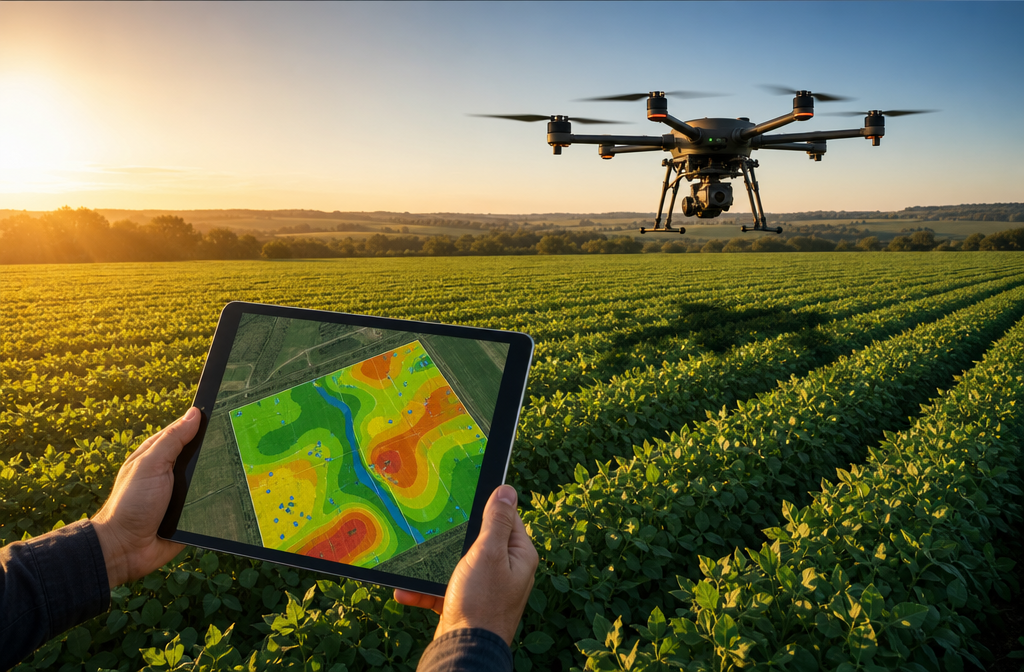
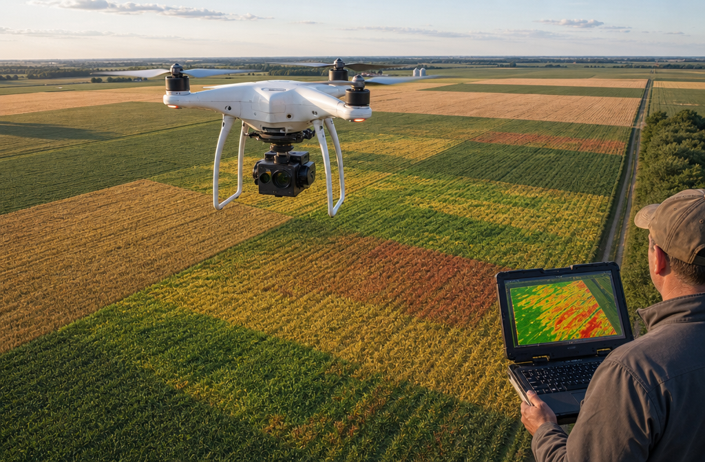
UAVs and Aerial Survey Capabilities
Unmanned aerial vehicles have moved from novelty to necessity in agricultural surveying. A drone equipped with a multispectral or thermal camera can survey hundreds of acres in a single flight, generating data that would take a ground crew days to collect manually. This speed advantage is critical during fast-moving crop stress events such as disease outbreaks, drought stress, or pest infestations where early detection directly translates to yield protection.
Modern agricultural UAVs capture several types of data:
| Data Type | Sensor Used | Agricultural Application |
|---|---|---|
| RGB Imagery | Standard camera | Canopy cover, plant stand counts |
| NDVI Maps | Multispectral camera | Crop health and chlorophyll levels |
| Thermal Imagery | Thermal camera | Irrigation uniformity, disease detection |
| LiDAR Point Clouds | LiDAR scanner | Terrain mapping, drainage planning |
| 3D Surface Models | Photogrammetry | Soil erosion, earthwork planning |
The integration of drones with connected sensors and IoT platforms allows data to flow from the field to farm management software in near real time [3]. A farmer can fly a field in the morning, receive a processed NDVI map by midday, and dispatch a variable-rate sprayer to address identified stress zones the same afternoon. This closed-loop workflow was largely theoretical five years ago; in 2026 it is routine on well-equipped operations.
For those exploring how aerial survey methods translate across property types, the principles share common ground with drone roof survey services used in built environments, where UAV-captured imagery similarly reduces inspection time and improves data quality.
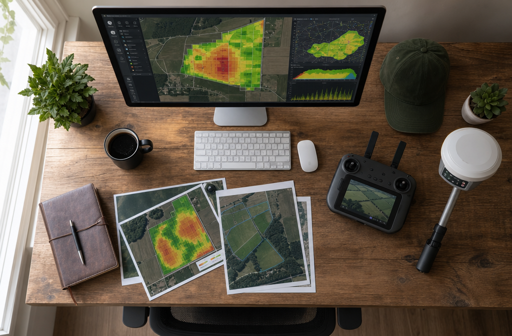
GIS: Turning Survey Data into Actionable Field Intelligence
Raw positioning data and drone imagery have limited value without a framework for analysis and visualization. Geographic Information Systems (GIS) provide that framework, allowing farmers and agronomists to layer multiple data sources into unified field maps that reveal patterns invisible to the naked eye.
A typical GIS workflow in precision farming includes:
- Base layer creation — importing field boundaries, soil survey data, and historical yield maps
- Data integration — overlaying current-season drone imagery, soil moisture sensor readings, and weather data
- Zone delineation — identifying management zones with similar soil and productivity characteristics
- Prescription generation — creating variable-rate application maps for seeds, fertilizers, and pesticides
- Performance monitoring — comparing actual yields against predicted outcomes to refine future decisions
GPS technology enables real-time data collection with accurate position information, supporting farm planning, field mapping, soil sampling, tractor guidance, crop scouting, variable-rate applications, and yield mapping [4]. When these functions are unified within a GIS environment, the cumulative analytical power is substantially greater than any single technology used in isolation.
"The shift from uniform field management to zone-based management, enabled by GIS and precision survey data, is arguably the single most impactful change in crop production efficiency over the past two decades."
ROI for Farmers and Land Professionals: What the Numbers Show
Quantifying the Financial Returns
The business case for precision farming surveying technologies rests on a straightforward equation: do the cost savings and yield gains outweigh the investment in hardware, software, and training? For most operations above a threshold scale, the answer is clearly yes.
The USDA has documented that precision agriculture technologies including yield mapping, soil mapping, auto-guidance machinery steering, and variable-rate technologies generate measurable cost savings on U.S. corn farms [6]. Key financial benefits include:
- Input reduction: Variable-rate fertilizer application typically reduces nitrogen use by 10 to 15% without yield loss
- Fuel savings: Autosteering eliminates overlapping passes, reducing fuel consumption by 5 to 10%
- Labor efficiency: Automated guidance reduces the skill level required for field operations, lowering labor costs
- Yield optimization: Targeted interventions based on UAV and sensor data can improve yields by 5 to 20% depending on baseline management quality
For a 2,000-acre corn operation, these savings can represent tens of thousands of dollars annually, with many farms reporting full return on investment within two to four growing seasons.
The Surveyor's Perspective: New Revenue Streams
Precision farming is not only transforming farm economics; it is creating new professional opportunities for chartered surveyors and land professionals. Boundary surveys, land valuations, and topographic assessments are increasingly requested in digital GIS-compatible formats that integrate directly with farm management platforms.
Surveyors who invest in UAV capabilities and GIS competency are finding demand from agricultural clients who need:
- High-resolution topographic surveys for drainage and irrigation planning
- Boundary surveys that define field extents with the precision required for variable-rate prescription mapping
- Land condition assessments that inform purchase decisions and property valuations
- Specific defect reports for agricultural structures and drainage infrastructure
The overlap between traditional surveying competencies and precision agriculture requirements is substantial. Professionals already skilled in spatial data collection and analysis are well positioned to serve this growing market.
Challenges, Emerging Technologies, and the Road Ahead
Barriers to Wider Adoption
Despite compelling evidence of financial and environmental benefits, precision farming surveying technologies face real barriers to universal adoption. The U.S. Government Accountability Office has identified high upfront costs, technological complexity, and data management challenges as the primary obstacles preventing widespread uptake, particularly among smaller farming operations [7].
The cost challenge is multifaceted. RTK base stations, high-quality UAVs with multispectral sensors, and farm management software subscriptions represent a combined investment that can exceed $50,000 for a fully equipped operation. While costs have fallen significantly and continue to do so, the initial outlay remains prohibitive for many small family farms.
Data management presents a separate challenge. Precision farming generates enormous volumes of spatial data — yield maps, soil samples, drone imagery, sensor logs — that must be stored, processed, and interpreted. Without adequate technical support or agronomic expertise, this data can become a burden rather than an asset.
Additional barriers include:
- Connectivity gaps: Rural broadband limitations restrict real-time data transmission in many regions
- Interoperability issues: Data formats vary between equipment manufacturers, complicating integration
- Skills gaps: Operators need training to use complex systems effectively
- Privacy concerns: Farm data shared with technology providers raises questions about ownership and commercial use
Emerging Technologies Expanding the Frontier
Research into next-generation precision farming technologies points toward even more powerful integration of artificial intelligence, robotics, blockchain, and the Internet of Things [8]. Several developments are particularly significant for surveying applications:
AI-powered image analysis is accelerating the interpretation of UAV-captured imagery. Machine learning models can now identify individual plant stress symptoms, count plants per row, and estimate yield potential from aerial photographs with accuracy approaching that of trained agronomists.
Agricultural robotics are extending precision management to tasks that previously required human labor. Ground robots equipped with cameras and sensors can conduct detailed soil inspections, apply targeted micro-doses of herbicide to individual weeds, and collect tissue samples for laboratory analysis [9]. These robots generate continuous streams of georeferenced data that feed directly into GIS farm management systems.
Blockchain-based data management is emerging as a solution to data ownership and supply chain transparency challenges. By recording farm inputs, practices, and yields on a distributed ledger, farmers can demonstrate sustainable production credentials to buyers and regulators with verifiable precision.
IoT sensor networks embedded in fields provide continuous monitoring of soil moisture, temperature, salinity, and nutrient levels at multiple depths. When combined with UAV surveys and GNSS positioning, these networks create a comprehensive digital model of field conditions that supports fully automated irrigation and fertilization decisions.
Sustainability: The Environmental Dividend
Precision farming's contribution to environmental sustainability deserves explicit recognition. GPS and GIS-enabled precise application of inputs leads to more environmentally responsible farming operations by reducing the over-application of fertilizers and pesticides that cause soil degradation and water pollution [10].
Variable-rate technology, guided by detailed survey data, ensures that nutrients are applied only where soil tests indicate deficiency and only at rates matched to realistic yield potential. This approach reduces nutrient runoff into waterways, lowers greenhouse gas emissions from excess nitrogen application, and preserves soil biological health over the long term.
For land professionals assessing agricultural properties, understanding a farm's precision management history is becoming an important component of property valuation and due diligence. Farms with documented precision management records often demonstrate more consistent yield histories and better soil condition scores, factors that influence long-term asset value.
Precision Farming: How Surveying Technologies are Transforming Agriculture in 2026 — Practical Implementation Guide
Getting Started: A Stepwise Approach
For farmers and land managers considering entry into precision agriculture, a phased approach reduces financial risk while building competency progressively.
Phase 1 — Foundation (Year 1)
- Install a yield monitor and GPS receiver on primary harvest equipment
- Commission a professional soil sampling survey with GIS-mapped results
- Establish field boundary maps in a compatible farm management software platform
Phase 2 — Expansion (Year 2)
- Upgrade to RTK-GPS autosteering on primary tillage and planting equipment
- Conduct first UAV survey to establish baseline crop health imagery
- Begin variable-rate fertilizer application based on soil map zones
Phase 3 — Integration (Year 3 and beyond)
- Deploy IoT soil moisture sensors in representative field zones
- Integrate drone, sensor, and yield data into a unified GIS dashboard
- Explore AI-powered analytics tools for predictive yield modeling
Choosing the Right Professional Support
Implementing precision farming surveying technologies effectively requires professional support at multiple stages. Agronomists, GIS specialists, and chartered surveyors each play distinct roles.
When selecting a surveying professional for agricultural applications, look for:
- Demonstrated experience with UAV survey operations and data processing
- Competency in GIS software relevant to agricultural management
- Familiarity with GNSS correction networks and RTK positioning systems
- Understanding of agricultural data formats and farm management software integration
Working with chartered surveyors who understand both spatial data collection and land management principles ensures that survey outputs are practically useful rather than technically impressive but operationally disconnected.
For land managers dealing with complex property boundaries that affect field planning and variable-rate zone delineation, accurate boundary surveys are an essential prerequisite to precision management implementation.
Conclusion
Precision Farming: How Surveying Technologies are Transforming Agriculture in 2026 represents one of the most consequential intersections of technology and land management in modern history. RTK-GPS delivers the positional accuracy that makes automated field operations possible. UAVs provide rapid, high-resolution aerial intelligence that identifies problems before they become yield-limiting events. GIS platforms transform these data streams into actionable management decisions that reduce costs, improve yields, and lower environmental impact.
The financial returns are well documented. The environmental benefits are measurable. The professional opportunities for surveyors and land managers who develop precision agriculture competencies are expanding rapidly.
Actionable next steps for farmers:
- Audit current equipment for GPS compatibility and identify upgrade pathways
- Commission a baseline soil survey with GIS mapping to establish management zones
- Schedule a UAV crop health survey before the next growing season to establish benchmark imagery
- Consult a chartered surveyor experienced in agricultural land to ensure field boundaries and topographic data are accurate and GIS-compatible
Actionable next steps for land professionals:
- Invest in UAV certification and multispectral sensor capability
- Develop GIS proficiency in agricultural data formats and farm management software
- Build relationships with agronomists and precision agriculture technology providers
- Position boundary survey and topographic survey services explicitly for agricultural precision management clients
The tools exist. The data is available. The farms and professionals that act on this knowledge in 2026 will hold a significant competitive and financial advantage over those who wait.
References
[1] Rtk Gps – https://www.rtlsalliance.com/rtls-digital-twin/technologies/rtk-gps?utm_source=openai
[2] Agriculture – https://hxgnsmartnet.com/industries/agriculture?utm_source=openai
[3] Precision Agriculture Technology – https://www.kuhn.co.uk/agricultural-methods/types-agriculture/precision-agriculture/precision-agriculture-technology?utm_source=openai
[4] Farming Gps – https://www.gps.gov/farming-gps?utm_source=openai
[5] Chart Detail – https://ers.usda.gov/data-products/charts-of-note/chart-detail?chartId=110550&utm_source=openai
[6] Cost Savings From Precision Agriculture Technologies On U S Corn Farms – https://ers.usda.gov/amber-waves/2016/may/cost-savings-from-precision-agriculture-technologies-on-u-s-corn-farms?utm_source=openai
[7] Gao 24 105962 – https://www.gao.gov/products/gao-24-105962?utm_source=openai
[8] arxiv – https://arxiv.org/abs/2404.06341?utm_source=openai
[9] Agriculture – https://www.robotlab.com/agriculture?utm_source=openai
[10] Agriculture – https://archive.gps.gov/applications/agriculture/?utm_source=openai