A boundary error of just 30 centimeters once cost a UK developer over £200,000 in legal fees and project delays — a figure that underscores exactly why precision in land surveying is not a luxury but a legal and financial necessity. The good news for 2026 is that next-gen GPS and GNSS: achieving centimeter-level accuracy in land surveys is no longer the exclusive domain of government agencies or aerospace contractors. It is now accessible, affordable, and increasingly standard practice for professional surveyors across the UK and beyond.
This article examines the technologies driving that transformation, how they apply to real-world scenarios such as boundary disputes and infrastructure projects, and what to look for when selecting GNSS equipment and services in 2026.
Key Takeaways
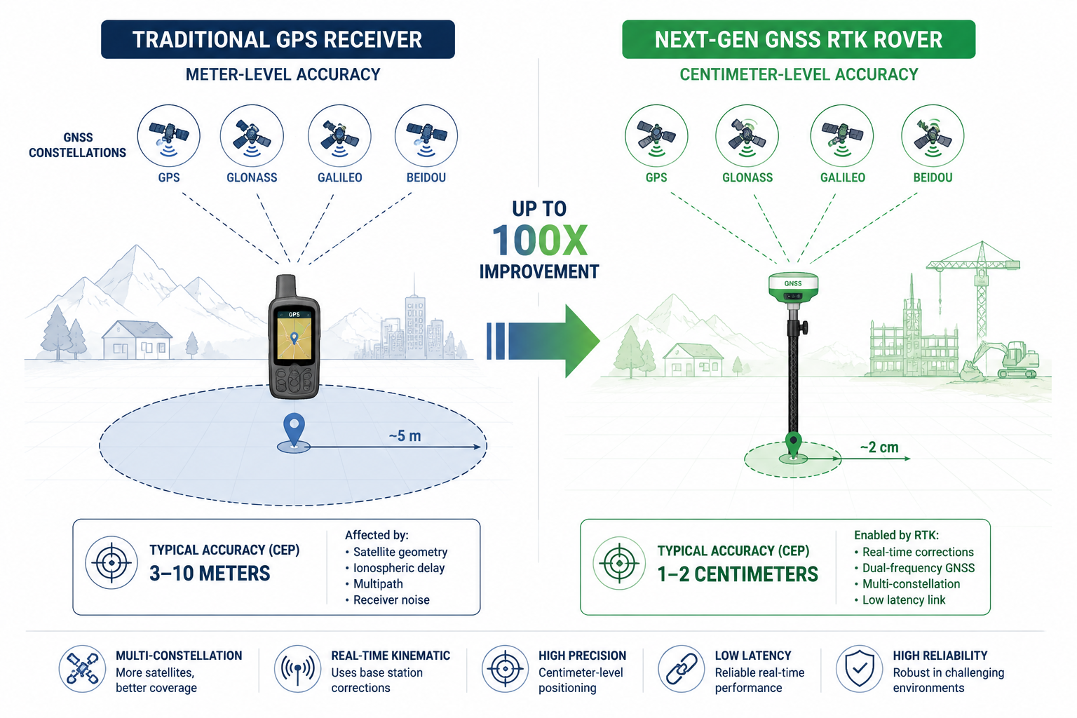
- Modern GNSS systems can now achieve 1-2 cm horizontal accuracy in real time, a dramatic improvement over the 3-5 metre accuracy of standard GPS.
- Real-Time Kinematic (RTK) and Precise Point Positioning (PPP) are the two dominant correction technologies enabling centimeter-level results.
- Network RTK services eliminate the need for on-site base stations, reducing equipment costs and setup time significantly.
- Multi-constellation receivers — drawing signals from GPS, GLONASS, Galileo, and BeiDou — deliver more reliable accuracy in challenging environments.
- Choosing the right GNSS system in 2026 requires evaluating accuracy specifications, correction service availability, tilt compensation, and total cost of ownership.
How Modern GNSS Technology Delivers Centimeter-Level Accuracy
Standard GPS, as most people know it, delivers positional accuracy in the range of 3 to 5 metres under open-sky conditions. That level of precision is perfectly adequate for navigation but wholly inadequate for professional land surveying, where errors of even a few centimetres can have serious legal and financial consequences.
Next-gen GPS and GNSS: achieving centimeter-level accuracy in land surveys relies on a layered set of enhancements that correct the errors inherent in raw satellite signals.
The Four Error Sources GNSS Must Overcome
Before understanding the solutions, it helps to understand the problems. Four primary error sources degrade raw GNSS signals:
| Error Source | Typical Impact | Correction Method |
|---|---|---|
| Ionospheric delay | 1-10 metres | Multi-frequency signals, modelling |
| Tropospheric delay | 0.5-2 metres | Atmospheric models, dual-frequency |
| Satellite clock drift | Centimetres to metres | Precise clock corrections |
| Multipath (signal bounce) | Centimetres to metres | Antenna design, IMU fusion |
Real-Time Kinematic (RTK): The Industry Standard
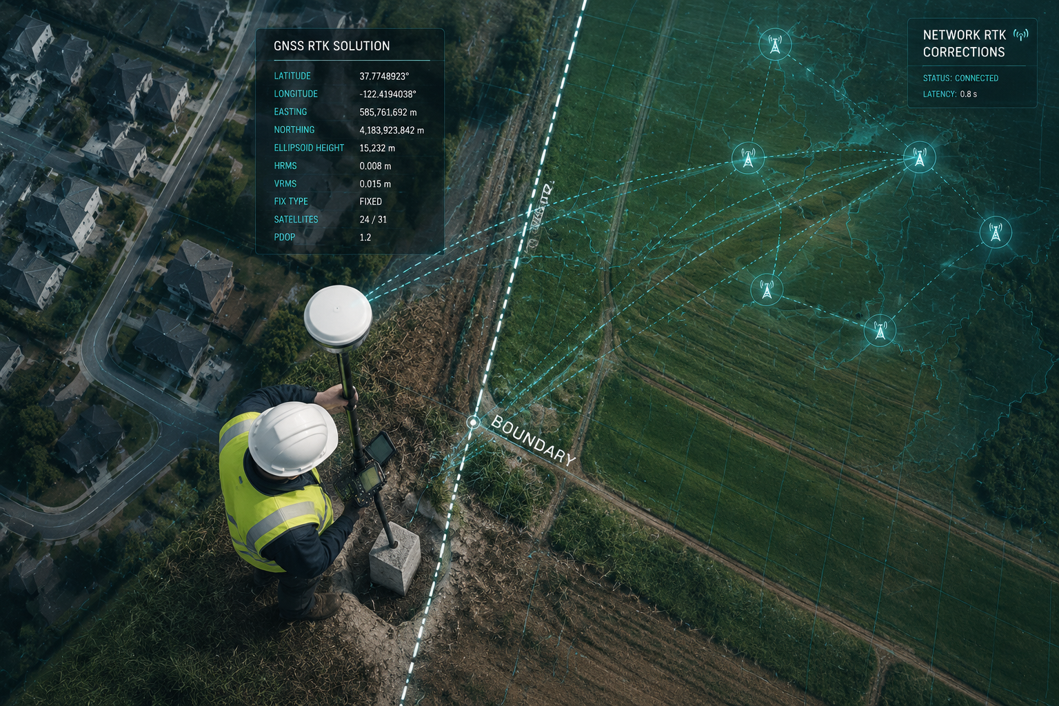
RTK is currently the most widely used method for achieving centimeter-level accuracy in professional land surveys. It works by comparing the carrier-phase of GNSS signals received at a rover (the mobile unit a surveyor carries) against those received at a fixed reference station with a precisely known position. The difference — known as the correction — is transmitted to the rover in real time, typically over cellular or radio link.
RTK systems routinely achieve 1-2 cm horizontal accuracy and 2-3 cm vertical accuracy under good conditions [4]. Services such as RTKdata stream real-time NTRIP corrections from more than 20,000 reference stations across 145+ countries, meaning surveyors no longer need to set up and manage their own base stations [4].
Precise Point Positioning (PPP): The Emerging Alternative
PPP takes a different approach. Instead of relying on a local reference station, it uses precise satellite orbit and clock corrections broadcast globally — either via satellite or internet — to correct the rover's position. Recent advances in PPP have brought real-time accuracy to the centimetre level by leveraging multi-frequency signals from modernised GNSS constellations [8].
Trimble's RTX technology, for example, delivers real-time centimetre-level corrections globally via satellite or cellular/IP, removing the dependency on local base station infrastructure entirely [2]. This is particularly valuable in remote or offshore survey environments where establishing a base station is impractical.
Multi-Constellation Reception: More Satellites, Better Geometry
A critical enabler of modern accuracy is the ability to receive signals from multiple satellite constellations simultaneously:
- GPS (United States) — 31 operational satellites
- GLONASS (Russia) — 24 operational satellites
- Galileo (European Union) — 30+ operational satellites
- BeiDou (China) — 35+ operational satellites
Receivers that track all four constellations have access to 100+ satellites at any given time. More satellites mean better geometric diversity, faster ambiguity resolution, and more reliable accuracy — especially in urban canyons, near tree lines, or in other signal-obstructed environments.
Practical Applications: Boundary Disputes, Infrastructure, and Beyond
The real-world value of next-gen GPS and GNSS: achieving centimeter-level accuracy in land surveys becomes clearest when examining specific professional applications. Centimetre-level positioning is not merely a technical achievement — it is a practical tool that resolves disputes, accelerates construction, and protects property rights.
Boundary Disputes and Legal Surveys
Boundary disputes are among the most contentious and costly property issues a landowner can face. Accurate survey data is often the deciding factor in legal proceedings. When a chartered surveyor presents GNSS-derived coordinate data with a demonstrable accuracy of 1-2 cm, that evidence carries significant weight.
Traditional total stations and optical instruments remain valuable, but combining them with RTK GNSS dramatically accelerates the data collection process while maintaining the accuracy required for legally defensible boundary surveys. For complex cases that may proceed to litigation, surveyors producing expert witness reports increasingly rely on GNSS data as a core component of their evidence base.
"Centimetre-level GNSS data does not just speed up surveys — it produces a defensible, repeatable, and independently verifiable record of ground truth."
Structural and Subsidence Monitoring
GNSS technology is also transforming how surveyors monitor structural movement over time. The Septentrio Mosaic-X5 GNSS receiver, for instance, achieves 0.6 cm + 0.5 ppm horizontal RTK accuracy, making it well-suited for detecting subtle ground movement in land monitoring applications [6]. This level of sensitivity is directly relevant to subsidence surveys, where detecting millimetre-scale movement over weeks or months can provide early warning of serious structural problems.
Continuous GNSS monitoring stations can be installed on structures or ground anchors to track movement automatically, generating alerts when displacement exceeds defined thresholds.
Infrastructure and Construction Layout
On large infrastructure projects — roads, pipelines, utilities — GNSS-guided machine control and layout surveying can reduce rework costs substantially. Network RTK services provide nationwide centimetre-level accuracy without on-site base stations, making it practical to maintain consistent accuracy across large project footprints [9].
Post-processed solutions such as Applanix POSPac PP-RTX extend this capability to mobile mapping platforms — vehicles and drones — delivering centimetre-level accuracy for corridor mapping and as-built surveys without base station dependency [7].
Drone and Aerial Survey Integration
UAV-mounted GNSS receivers have transformed topographic survey workflows. A drone equipped with a high-accuracy GNSS module — such as the Septentrio Mosaic-X5 — can capture dense point clouds and orthomosaic imagery georeferenced to centimetre accuracy [6]. This directly supports drone roof surveys and broader aerial inspection workflows, reducing the need for ground control points and speeding up data processing.
The FJDynamics StellarFusion platform exemplifies this trend, offering global centimetre-level accuracy with over 99.9% availability for applications spanning autonomous vehicles, drones, and precision surveying [5].
Party Wall and Dilapidation Surveys
Precise positioning is increasingly relevant even in urban property surveys. When preparing a schedule of condition report prior to construction work, or when assessing a schedule of dilapidations at lease end, accurate spatial records of existing conditions — tied to a reliable coordinate system — provide a defensible baseline that protects all parties.
2026 Buyer's Guide: Selecting the Right GNSS System for Centimeter-Level Surveys
With dozens of systems on the market, selecting the right GNSS equipment requires a structured approach. The following framework addresses the key decision points for professional surveyors evaluating systems in 2026.
Key Selection Criteria
1. Accuracy Specification
Always examine the manufacturer's stated RTK accuracy under controlled conditions. Look for:
- Horizontal RTK accuracy of 8 mm + 1 ppm or better
- Vertical RTK accuracy of 15 mm + 1 ppm or better
- Initialisation time under 10 seconds in open sky
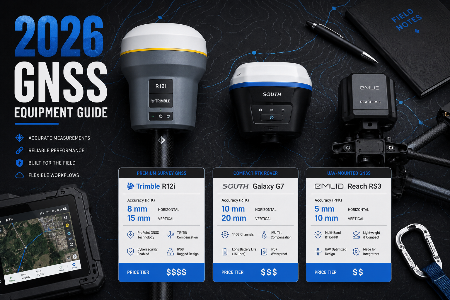
The Septentrio Mosaic-X5, for example, specifies 0.6 cm + 0.5 ppm horizontal and 1 cm + 1 ppm vertical RTK accuracy [6] — performance that places it among the most precise compact receivers available.
2. Tilt Compensation
Traditional RTK surveys require the pole to be held perfectly vertical — a constraint that slows down work and introduces human error on uneven terrain. Modern systems with IMU-based tilt compensation remove this requirement. The Trimble R12i, for instance, uses integrated inertial measurement to allow accurate measurement even when the pole is tilted, significantly boosting productivity in challenging environments [1].
3. Correction Service Compatibility
Evaluate whether the receiver supports:
- NTRIP (internet-based correction streams)
- Satellite-delivered corrections (e.g., Trimble RTX [2])
- Local base station (traditional RTK)
Network RTK services such as RTKdata (20,000+ reference stations, 145+ countries) [4] and TraceVRTK (1.5-inch precision, from $50/month per device) [3] offer flexible, cost-effective correction options for surveyors who want to avoid base station ownership costs.
4. Multi-Constellation and Multi-Frequency Support
At minimum, a 2026 professional GNSS receiver should support:
| Feature | Minimum Standard | Premium Standard |
|---|---|---|
| Constellations | GPS + GLONASS | GPS + GLONASS + Galileo + BeiDou |
| Frequencies | Dual-frequency (L1/L2) | Triple-frequency (L1/L2/L5) |
| Channels | 100+ | 400+ |
Triple-frequency receivers resolve carrier-phase ambiguities faster and perform better in partially obstructed environments.
5. Sensor Fusion Capabilities
Emerging research demonstrates that integrating visual-inertial odometry with GNSS carrier-phase measurements significantly improves robustness in urban environments where satellite visibility is intermittent [10]. Similarly, lidar-aided GNSS ambiguity resolution is enabling centimetre-level vehicle positioning in dense urban settings. Buyers working in cities or near structures should prioritise receivers with strong IMU integration and, where budget allows, compatibility with lidar or camera fusion workflows.
6. Total Cost of Ownership
Hardware purchase price is only part of the equation. Factor in:
- Annual correction service subscriptions
- Software licences for data processing
- Warranty and support costs
- Training requirements
Entry-level professional RTK systems with network correction subscriptions can deliver 2 cm accuracy for a total cost of ownership significantly lower than owning and maintaining a dedicated base station setup.
Recommended System Categories for 2026
High-End Field Rovers (full-feature, IMU tilt)
Best for: boundary surveys, legal surveys, complex terrain
Example capability: Trimble R12i-class systems with integrated IMU and multi-constellation support [1]
Compact Multi-Constellation Receivers
Best for: UAV integration, mobile mapping, monitoring
Example capability: Septentrio Mosaic-X5 class — sub-centimetre RTK, compact form factor [6]
Network RTK Subscription Services
Best for: firms wanting to reduce capital expenditure
Example capability: RTKdata NTRIP streams, TraceVRTK virtual reference station corrections [3][4]
Post-Processed Centimetre Accuracy
Best for: mobile surveys, corridor mapping, remote areas
Example capability: Applanix POSPac PP-RTX for post-mission centimetre accuracy without base stations [7]
Conclusion
The gap between standard GPS and professional-grade GNSS accuracy has never been wider — or more consequential. In 2026, next-gen GPS and GNSS: achieving centimeter-level accuracy in land surveys is not a future aspiration; it is a present-day standard that professional surveyors, property developers, and legal teams should expect and demand.
The technology has matured to the point where centimetre-level accuracy is achievable across a wide range of environments, budgets, and use cases — from compact UAV-mounted receivers to full-featured field rovers with IMU tilt compensation and global correction services.
Actionable next steps for professionals and property owners in 2026:
- Verify accuracy credentials — When commissioning a land survey, ask specifically about the GNSS system used and its stated RTK accuracy specification.
- Engage qualified professionals — Work with chartered surveyors who have demonstrable experience with RTK and network GNSS workflows.
- Consider monitoring applications — For properties in areas of known ground movement, explore continuous GNSS monitoring as part of a subsidence survey strategy.
- Evaluate correction service costs — If purchasing equipment, compare network RTK subscription costs against base station ownership before committing to a hardware configuration.
- Document for legal protection — Ensure GNSS survey data is archived with full metadata, including accuracy logs, for use in future boundary or structural survey contexts.
Centimetre-level GNSS accuracy is a powerful tool. Used correctly, it protects property rights, accelerates construction, and provides the kind of defensible, repeatable evidence that resolves disputes before they escalate.
References
[1] Trimble R12i – https://geospatial.trimble.com/en/products/hardware/trimble-r12i/?utm_source=openai
[2] Rangepoint RTX – https://positioningservices.trimble.com/industries/agriculture/rangepoint-rtx/?utm_source=openai
[3] TraceNav – https://tracenav.net/?utm_source=openai
[4] Surveying – https://rtkdata.com/surveying/?utm_source=openai
[5] StellarFusion – https://agriculture.fjdynamics.com/product/stellarfusion?utm_source=openai
[6] Septentrio Mosaic X5 Land Monitoring Drone – https://uav-gnss.com/septentrio-mosaic-x5-land-monitoring-drone/?utm_source=openai
[7] Applanix POSPac PP-RTX – https://applanix.trimble.com/en/services/applanix-pospac-pp-rtx?utm_source=openai
[8] PPP GNSS Delivers Real-Time Positioning With Centimeter Accuracy – https://www.gpsworld.com/ppp-gnss-delivers-real-time-positioning-with-centimeter-accuracy/?utm_source=openai
[9] NetworkRTK – https://www.lefixea.com/article/networkrtk8?utm_source=openai
[10] arxiv – https://arxiv.org/abs/2303.01291?utm_source=openai