
Nearly 40% of party wall disputes in urban areas involve disagreements over pre-existing damage — disagreements that accurate, timestamped survey data could resolve in hours rather than months. As deep basement excavations and complex foundation projects surge across London and South East England during the 2026 construction market recovery, drone surveys for party wall awards are rapidly becoming the most powerful tool available to chartered surveyors, building owners, and adjoining owners alike.
Drone Surveys for Party Wall Awards: Enhancing Accuracy in 2026 Deep Foundation and Excavation Projects represents a genuine shift in how the industry captures, documents, and defends evidence under the Party Wall etc. Act 1996. This article explores exactly how that shift works, what it costs, and why it matters for anyone involved in excavation or deep foundation work near a shared boundary.
Key Takeaways 📋
- Drone surveys dramatically reduce manual risk on deep excavation sites while capturing millimetre-level accuracy data for party wall awards.
- RICS-compliant drone protocols are now standard practice among leading London surveying firms in 2026.
- Costs range from £300 to £800+ VAT depending on property size and complexity, with all fees confirmed upfront. [3]
- A thorough schedule of condition supported by drone imagery is the strongest protection against disputed damage claims.
- Multiple firms across North London and South East England now offer drone survey services specifically for party wall matters. [1][4]
What Are Drone Surveys and Why Do They Matter for Party Wall Awards?
A party wall award is a legally binding document that sets out the rights and responsibilities of both the building owner and the adjoining owner during notifiable construction work. Under the Party Wall etc. Act 1996, this typically includes deep excavations within 3 or 6 metres of a neighbouring structure — a threshold explained in detail in the Party Wall Act 3 Metre Rule.
Traditionally, surveyors conducted site inspections on foot, using tape measures, spirit levels, and handheld cameras. For straightforward projects, this works. For deep foundation and excavation projects — basements, underpinning, piled foundations — it is often inadequate. Access is restricted, angles are awkward, and critical structural data near the party wall line is simply missed.
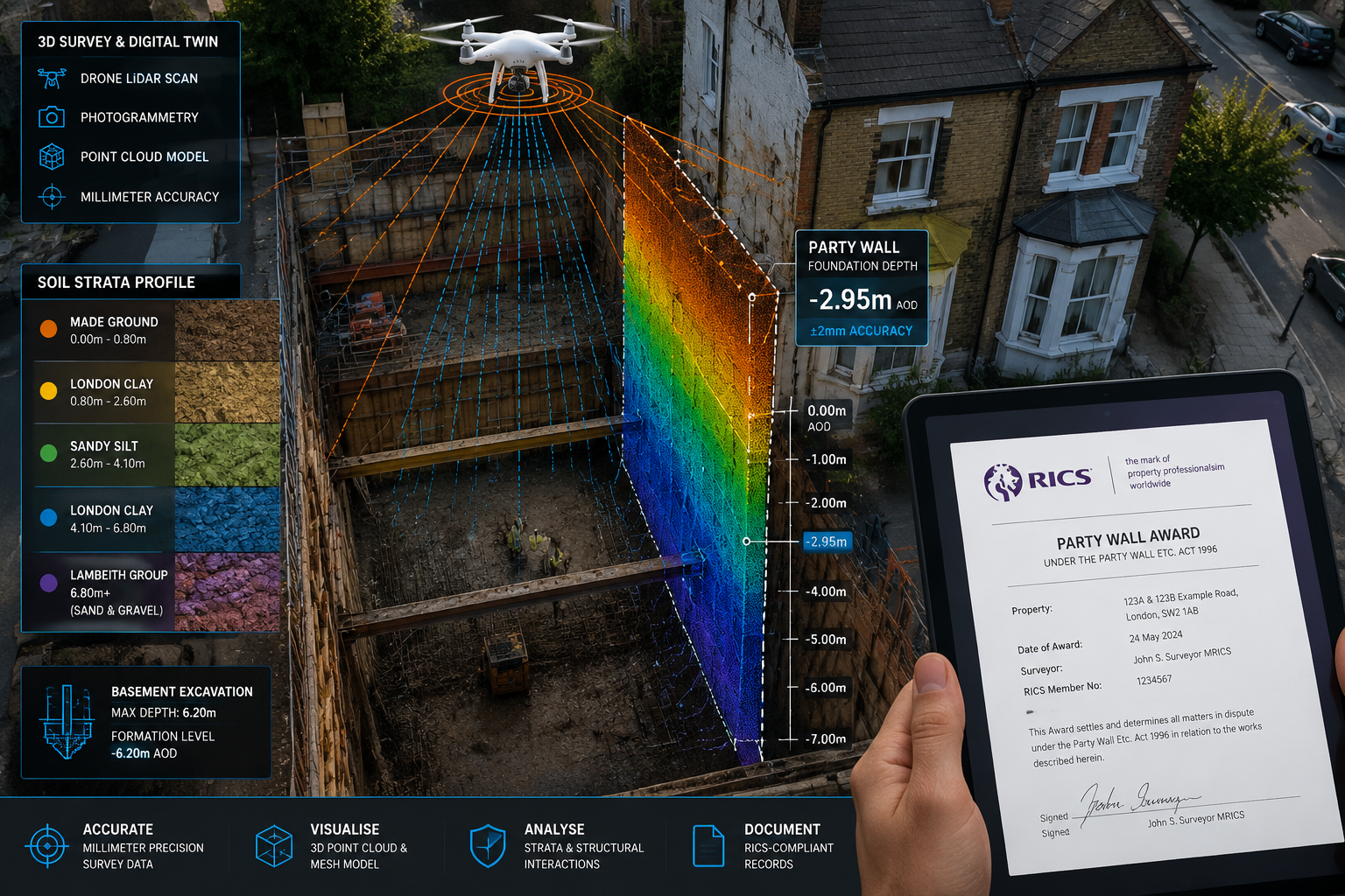
Drone surveys change this entirely. Equipped with high-resolution cameras, LiDAR sensors, and photogrammetry software, modern survey drones can:
- Capture sub-centimetre accuracy measurements of walls, foundations, and excavation depths
- Produce 3D point cloud models of the entire site perimeter
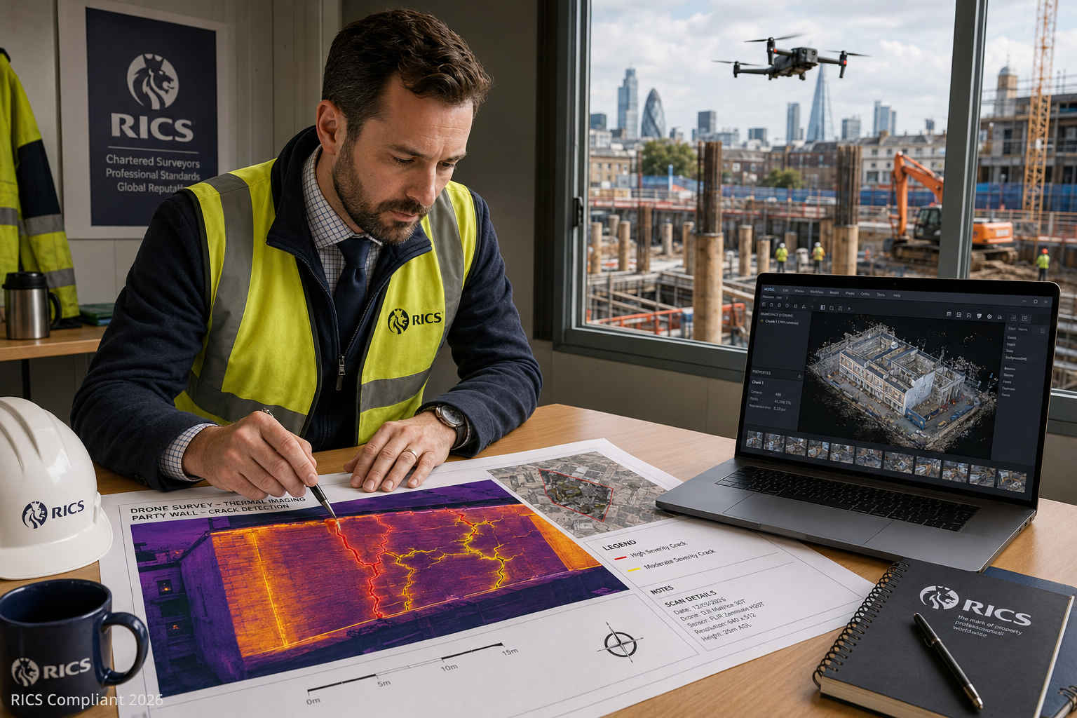
- Record thermal imaging data to detect hidden moisture or structural stress
- Generate georeferenced orthomosaic maps that can be overlaid on title plans
💬 "Drone technology is not replacing the surveyor — it is giving the surveyor eyes in places no human can safely reach."
For a party wall agreement to hold up under scrutiny, the underlying evidence must be unimpeachable. Drone-captured data provides exactly that.
How Drone Surveys for Party Wall Awards Enhance Accuracy in Deep Foundation Projects
The Core Technical Advantage
Deep foundation projects — including contiguous piled walls, secant piling, and mass concrete underpinning — create significant ground movement risk. The Party Wall etc. Act 1996 requires surveyors to document the condition of adjoining structures before, during, and after such works. This is where drone surveys deliver their most measurable value.
Key technical capabilities in 2026:
| Capability | Traditional Survey | Drone Survey |
|---|---|---|
| Measurement accuracy | ±10–20mm | ±1–3mm |
| Site access limitations | High | Very low |
| Time on site | 3–6 hours | 45–90 minutes |
| 3D modelling | Not available | Standard |
| Thermal imaging | Separate specialist | Integrated |
| Legal admissibility | Good | Excellent (timestamped) |
The Schedule of Condition Connection
One of the most important documents in any party wall matter is the party wall schedule of condition. This pre-construction record documents the existing state of the adjoining property. If damage to property in a party wall dispute arises later, the schedule of condition is the primary evidence.
Drone surveys supercharge this document in three ways:
- Complete external coverage — including roof slopes, chimney stacks, and upper-floor brickwork that ground-level inspectors cannot safely assess
- Georeferenced imagery — every photograph is tagged with precise GPS coordinates, making before-and-after comparisons legally robust
- Crack mapping overlays — existing cracks are measured and mapped digitally, eliminating the "that crack was already there" dispute
For projects involving subsidence surveys or complex ground conditions, this level of baseline documentation is not just helpful — it is essential.
RICS-Compliant Protocols in 2026
The Royal Institution of Chartered Surveyors (RICS) has progressively updated its guidance on the use of remote sensing and aerial survey technology. In 2026, RICS-registered firms operating drone surveys for party wall matters are expected to comply with:
- CAA (Civil Aviation Authority) Operational Authorisation — all commercial drone flights in the UK require appropriate permissions
- GDPR-compliant data handling — drone footage capturing neighbouring properties must be managed carefully
- Chain of custody documentation — all captured data must be timestamped, encrypted, and stored in a format admissible as legal evidence
- Qualified operator certification — GVC (General Visual Line of Sight Certificate) or equivalent is the minimum standard
Multiple RICS Chartered Surveyor firms in London now offer drone survey services specifically for party wall matters and building surveys. [2] This is no longer a niche offering — it is becoming standard practice among quality firms.
Practical Application: Drone Surveys for Party Wall Awards in 2026 Excavation Projects
Typical Project Workflow
Understanding how drone surveys integrate into the party wall process helps building owners and adjoining owners set realistic expectations.
Stage 1 — Party Wall Notice and Appointment
The building owner serves notice under the Party Wall etc. Act 1996. If the adjoining owner dissents or fails to respond, surveyors are appointed. At this stage, a drone survey is commissioned as part of the schedule of condition report process.
Stage 2 — Pre-Construction Drone Survey
The drone operator (working alongside or as part of the surveying team) conducts a full aerial survey of:
- The adjoining property's external elevations
- The party wall line and any shared structures
- The proposed excavation zone and surrounding ground conditions
- Roof structures, including any shared chimneys that may be affected
Stage 3 — Award Preparation
The drone data is processed into a 3D model and orthomosaic map. This is incorporated directly into the party wall award, providing a visual and measurable baseline.
Stage 4 — Monitoring During Works
For long-duration excavation projects, periodic drone surveys (monthly or at key construction milestones) track any changes to the adjoining structure. This creates a continuous evidence chain.
Stage 5 — Post-Construction Survey
A final drone survey confirms the condition of the adjoining property after works complete. Any new damage is immediately identifiable by comparison with the pre-construction baseline.
Cost Structure for 2026 Projects
Transparency on costs matters. Based on current market data: [3]
| Property Type | Drone Survey Cost (ex. VAT) |
|---|---|
| Small residential | From £300 |
| Medium/larger residential | £400–£600 |
| Commercial or complex structures | From £800 |
All costs are confirmed in advance based on scope and site conditions. [3] For most deep foundation projects, the drone survey cost represents a fraction of the potential dispute resolution costs — which can run into thousands of pounds in surveyor fees and legal expenses.
Geographic Availability
Drone survey services for party wall awards are now available across a wide geographic area:
- North London — multiple firms actively offering drone-assisted party wall surveys [1]
- South East England, including Kent — growing availability [4]
- Central and West London — strong coverage from RICS-registered firms [2]
For those working with chartered surveyors in London or across the South East, it is worth specifically asking whether drone survey capability is included in the party wall service offering.
Addressing Common Concerns About Drone Surveys in Party Wall Matters
"Is drone data legally admissible in party wall disputes?"
Yes — provided the data is collected by a qualified operator under CAA authorisation, timestamped, and stored with a proper chain of custody. Drone-captured evidence has been successfully used to resolve party wall disputes in 2025 and 2026, both in agreed awards and in tribunal proceedings.
"What about privacy concerns?"
This is a legitimate consideration. Professional drone operators conducting party wall surveys must:
- Notify affected parties before flight
- Limit data capture to the surveyed structures (not interiors or unrelated neighbouring properties)
- Store all data in GDPR-compliant systems
- Provide copies of imagery to all parties named in the party wall award
"Can drones access all site types?"
Modern survey drones operate effectively in most urban environments, including:
- ✅ Narrow terraced street frontages
- ✅ Deep basement excavations (using tethered or close-range drones)
- ✅ Properties with restricted ground-level access
- ✅ Listed buildings (with appropriate permissions)
- ✅ Multi-storey structures
There are limitations — severe weather, restricted airspace near airports, and certain listed building contexts may require additional permissions or alternative approaches. A qualified surveyor will assess site-specific constraints before commissioning a flight.
"Does drone survey data replace the surveyor's professional judgment?"
Absolutely not. The drone is a data capture tool, not a decision-making system. The RICS-registered surveyor interprets the data, applies professional judgment, and produces the party wall award. Drone technology enhances the quality of the evidence base — it does not replace the expertise required to assess it.
Why 2026 Is the Tipping Point for Drone-Assisted Party Wall Surveying
The Q1 2026 construction market recovery — following two years of subdued activity driven by interest rate pressures — has brought a significant uptick in basement conversion and deep foundation projects across London and the Home Counties. This surge in complex excavation work has coincided with three converging trends:
- Drone hardware costs falling — commercial survey drones capable of LiDAR and photogrammetry are now accessible to mid-sized surveying practices
- Software maturity — point cloud processing and 3D modelling software has become faster, more accurate, and more affordable
- Legal precedent building — a growing body of case outcomes demonstrates that drone evidence is taken seriously in party wall dispute resolution
The result is that drone surveys for party wall awards: enhancing accuracy in 2026 deep foundation and excavation projects is not a future aspiration — it is current best practice among leading firms.
For building owners planning excavation near a boundary, and for adjoining owners concerned about the impact of neighbouring works, engaging a surveyor who offers drone survey capability is now a meaningful quality differentiator.
Conclusion: Actionable Next Steps for Building Owners and Surveyors
Drone survey technology has matured to the point where it delivers measurable, legally robust improvements to the party wall award process — particularly for deep foundation and excavation projects where traditional access is limited and the stakes are high.
Here are the key actions to take in 2026:
✅ If you are a building owner planning excavation: Instruct a RICS-registered party wall surveyor who offers integrated drone survey services. Confirm that the pre-construction schedule of condition will include drone-captured imagery.
✅ If you are an adjoining owner: Request that the appointed surveyor uses drone survey data as part of the schedule of condition. This protects your property and strengthens your position if damage occurs.
✅ If you are a party wall surveyor: Review your current survey methodology. Drone-captured data is becoming an expected standard on complex excavation projects, and firms that cannot offer it risk being seen as behind the curve.
✅ Confirm costs upfront: Drone survey fees (£300–£800+ VAT depending on complexity) [3] should be agreed in writing before works commence, with clear terms on data storage and access.
✅ Check geographic availability: Services are now available across North London, South East England, and beyond — ask your surveyor directly. [1][4]
The combination of RICS expertise and drone precision is the most reliable way to protect all parties in a deep foundation or excavation project. The technology is here. The protocols are established. The only question is whether your current party wall process is taking full advantage of both.
References
[1] Party Wall Surveyor North London – https://efficientpartywall.co.uk/party-wall-surveyor-north-london/
[2] surveyorsorted.co.uk – https://www.surveyorsorted.co.uk
[3] Drone Roof Surveys London – https://www.houricanassociates.com/party-wall-news/drone-roof-surveys-london/
[4] Drone Survey – https://home-heroes.co.uk/drone-survey/
[5] partywall.info – https://www.partywall.info


