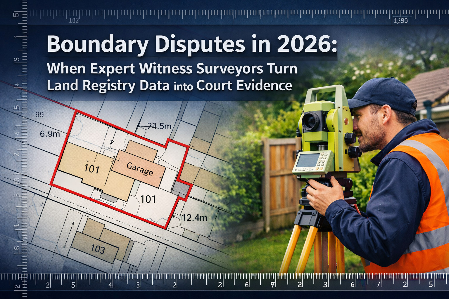
A 2024 High Court ruling fundamentally changed how boundary disputes are resolved in England and Wales. In Charlton v Forrest, the court established that judges are not bound by expert surveyors' agreed conclusions—even when both parties' experts concur on boundary location[1]. This landmark decision underscores a critical truth: Boundary Disputes in 2026: When Expert Witness Surveyors Turn Land Registry Data into Court Evidence require far more than technical measurements. They demand meticulous historical research, strategic evidence compilation, and expert presentation skills that transform raw data into compelling legal arguments.
The stakes are substantial. Property boundary conflicts affect thousands of homeowners annually, with resolution costs ranging from £5,000 to £50,000 when disputes escalate to litigation. However, most conflicts can be resolved through expert surveyor intervention before reaching courtroom proceedings—if the evidence is properly gathered, analyzed, and presented.
Key Takeaways
- 🏛️ Courts determine boundaries as matters of fact, not bound by expert surveyor agreements, making evidence quality paramount
- 📊 Land Registry plans have severe limitations under the "General Boundaries Rule" and often provide minimal value in precise boundary determination
- 📸 Historical aerial photographs dating back decades serve as critical evidence, particularly when original conveyance documents are missing
- 🎯 Professional licensing alone doesn't qualify surveyors as expert witnesses—specialized experience and courtroom presentation skills are essential
- ⚖️ Strategic evidence compilation combining site inspections, historical research, and modern surveying technology resolves most disputes without full litigation
Understanding the Evidence Landscape for Boundary Disputes in 2026
The Land Registry Limitation Problem
The foundation of most property ownership records—Land Registry title plans—suffers from a fundamental weakness that surprises many property owners. Under the "General Boundaries Rule," these plans are designed to show the general position of boundaries, not their precise legal location[1].
What this means in practice:
- Land Registry plans typically use a 2mm line width that can represent 2-3 meters on the ground
- Plans are "of little if any use" in identifying exact boundaries during disputes[1]
- Original conveyance documents often contain more precise boundary descriptions
- Historical deed plans may contradict current Land Registry representations
This limitation doesn't render Land Registry data useless—it simply means expert witness surveyors must look beyond these documents to build comprehensive evidence packages. Professional boundary surveys combine multiple evidence sources to establish defensible boundary positions.
The Evidence Hierarchy Courts Actually Use
When judges determine boundary locations, they consider evidence in a specific hierarchy of reliability:
| Evidence Type | Reliability Level | Key Considerations |
|---|---|---|
| Original Conveyance Deeds | Highest | Precise measurements, boundary descriptions, contemporaneous plans |
| Historical Aerial Photographs | Very High | Physical boundary features over time, Google Earth historical imagery[1] |
| Witness Testimony | High | Long-term residents, boundary maintenance history, possession evidence |
| Modern Survey Measurements | High | GPS coordinates, laser measurements, topographical assessments[2] |
| Land Registry Plans | Low | General boundaries only, limited precision[1] |
| Verbal Agreements | Variable | Depends on corroboration and documentation |
Expert witness surveyors in 2026 understand this hierarchy and structure their evidence compilation accordingly. They don't rely solely on modern measurements—they reconstruct the historical boundary position through documentary archaeology.
The Site Inspection Process: Building Your Evidence Foundation
Pre-Inspection Research and Preparation
Before stepping onto disputed property, expert surveyors conduct extensive desk-based research. This preparation phase determines the quality of evidence ultimately presented to courts or used in boundary dispute resolution.
Essential pre-inspection activities include:
-
Title Document Analysis 📄
- Obtaining all available title deeds from Land Registry
- Reviewing historical conveyances dating back 50+ years
- Identifying boundary descriptions and measurements in original documents
- Noting discrepancies between successive title plans
-
Historical Imagery Research 🛰️
- Accessing aerial photographs from multiple time periods
- Reviewing Google Earth historical imagery back to available dates[1]
- Obtaining Ordnance Survey maps from different decades
- Documenting boundary feature changes over time
-
Planning Records Investigation 🏗️
- Checking local authority planning applications affecting boundaries
- Reviewing building control records for extensions near boundaries
- Identifying permitted development that may have altered boundary features
- Obtaining approved site plans showing boundary treatments
-
Witness Identification 👥
- Determining long-term residents who may provide testimony
- Identifying previous property owners
- Locating maintenance contractors with boundary knowledge
- Documenting potential witness availability
This research phase typically requires 8-15 hours for straightforward disputes and 25-40 hours for complex cases involving missing documentation or significant historical changes.
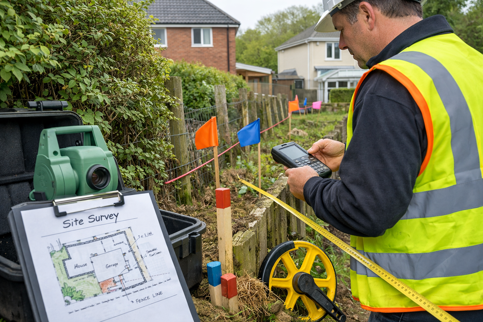
Conducting the Physical Site Inspection
Armed with historical research, expert witness surveyors conduct methodical site inspections that document every relevant physical feature. Modern technology enhances traditional surveying techniques to produce court-ready evidence.
Key inspection activities:
Boundary Feature Documentation 🔍
- Photographing all boundary features from multiple angles
- Measuring fence positions, wall thicknesses, and hedge centerlines
- Recording material types, construction methods, and condition
- Documenting wear patterns indicating long-term boundary positions
- Identifying physical evidence of historical boundary locations (old post holes, foundation remnants)
Precise Measurement Collection 📐
- Using GPS equipment to establish boundary coordinates[2]
- Employing laser distance measurers for precise dimensional data
- Creating topographical assessments showing ground level changes[2]
- Establishing permanent reference points for future verification
- Measuring from multiple datum points to ensure accuracy
Contextual Environment Recording 🌳
- Documenting sight lines and visibility between properties
- Recording drainage patterns and water flow directions
- Photographing vegetation growth patterns indicating boundary positions
- Noting access arrangements and historical usage patterns
- Identifying features mentioned in historical conveyance documents
Expert surveyors working across regions from Hertfordshire to West London understand that site conditions vary significantly. Urban boundary disputes often involve party walls and closely spaced properties, while rural disputes may center on hedgerows, ditches, or agricultural boundaries.
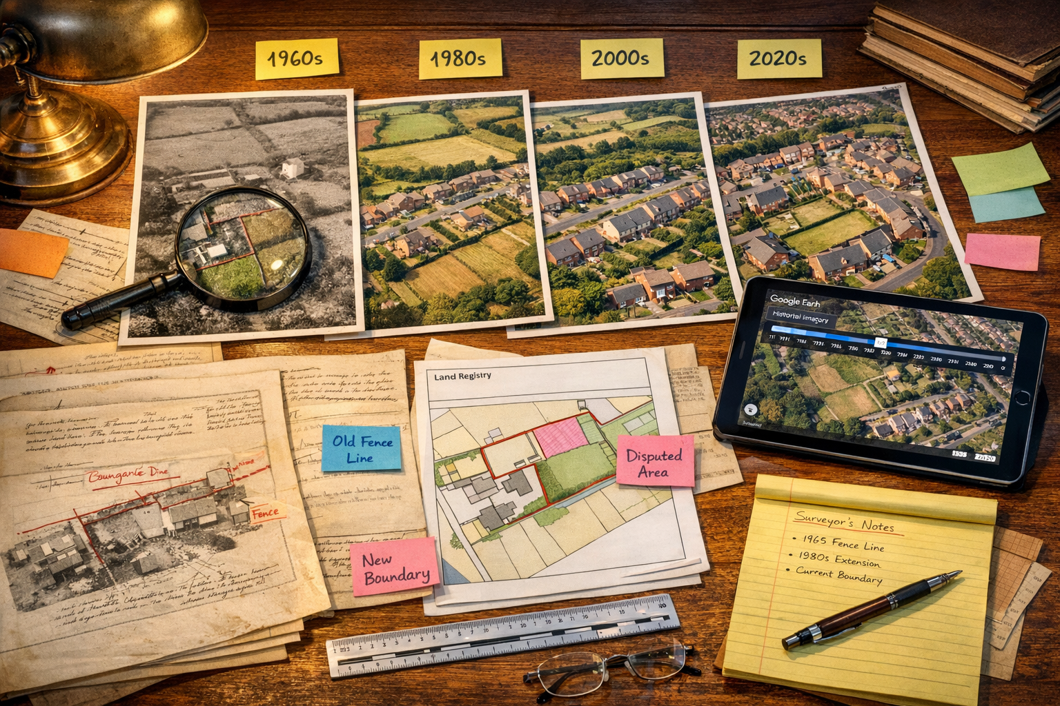
Historical Research: Transforming Archives into Admissible Evidence
The Power of Aerial Photography in Boundary Disputes
The Charlton v Forrest decision highlighted aerial photographs as "essential evidence" for establishing boundaries[1]. In 2026, expert witness surveyors leverage multiple aerial imagery sources spanning decades to demonstrate boundary positions over time.
Available aerial photography sources:
- Google Earth Historical Imagery: Dating back to 1984 in some UK locations, showing boundary feature evolution
- Historic England Archive: Aerial photographs from RAF reconnaissance flights (1940s-1960s)
- Ordnance Survey Historical Maps: Digital archives showing boundary representations across multiple survey periods
- Local Authority Planning Records: Site photographs accompanying planning applications
- Private Commercial Archives: Specialist aerial survey companies with historical image libraries
The evidential value lies not in single images but in chronological sequences showing boundary consistency or change. When a fence line appears in identical position across photographs from 1985, 2000, 2010, and 2024, this demonstrates long-term boundary establishment through possession and maintenance.
Conveyance Document Analysis Techniques
Original conveyance documents often contain boundary descriptions that Land Registry plans simplify or omit. Expert witness surveyors extract precise information from these historical legal documents:
Key elements to identify:
- Dimensional measurements (e.g., "measuring 47 feet 6 inches from the northwest corner")
- Boundary feature descriptions ("bounded to the north by a brick wall")
- Reference to physical monuments ("commencing at the oak tree")
- Abuttals (descriptions of neighboring properties)
- Parcels descriptions with metes and bounds measurements
Victorian and Edwardian conveyances frequently used imperial measurements with precision to the inch. Converting these to modern metric equivalents and overlaying them on current site conditions requires mathematical accuracy and understanding of historical surveying practices.
Professional expert surveyor advice emphasizes that conveyance interpretation isn't always straightforward—ambiguous language, missing plans, and contradictory descriptions require expert judgment to resolve.
Witness Statement Collection and Corroboration
While physical and documentary evidence forms the foundation, witness testimony provides crucial context about boundary history, maintenance, and usage. Expert witness surveyors coordinate with legal teams to identify and interview relevant witnesses.
Valuable witness categories:
- Long-term residents (20+ years) who remember boundary positions and maintenance
- Previous property owners with knowledge of boundary agreements or disputes
- Contractors who installed or maintained boundary features
- Neighboring property owners with independent recollections
- Local authority officers who may have inspected boundaries for planning purposes
Effective witness statements corroborate physical evidence. When a resident recalls a fence being replaced "in exactly the same position" in 1998, and aerial photographs confirm fence presence in that location from 1995 through 2024, the combined evidence becomes compelling.
Boundary Disputes in 2026: When Expert Witness Surveyors Turn Land Registry Data into Court Evidence
Qualifying as an Expert Witness: Beyond Professional Licensing
A critical misconception persists that any licensed surveyor can serve as an expert witness in boundary disputes. The reality is far more demanding. Professional licensing establishes baseline competence, but effective expert witness work requires specialized skills and experience[3].
Essential expert witness qualifications:
Technical Expertise 🎓
- Chartered status (MRICS or FRICS) with boundary dispute specialization
- Minimum 10-15 years practical experience in boundary determinations
- Knowledge of historical surveying practices and conveyancing law
- Proficiency with modern surveying technology and GIS systems
- Understanding of evidence rules and court procedures
Communication Skills 💬
- Ability to explain complex technical concepts in accessible language
- Experience presenting evidence under cross-examination
- Clear written communication in expert reports
- Professional demeanor maintaining impartiality
- Skill in creating visual evidence presentations
Professional Standing ⚖️
- Demonstrable track record of court-accepted testimony
- Professional indemnity insurance covering expert witness work
- Adherence to Civil Procedure Rules Part 35 requirements
- Membership in relevant professional bodies
- Absence of conflicts of interest
The distinction matters because courts scrutinize expert qualifications rigorously. An expert witness report must meet strict legal standards for admissibility, and the expert must withstand cross-examination while maintaining credibility.
Preparing the Expert Witness Report
The expert witness report represents the culmination of site inspections, historical research, and technical analysis. In 2026, these reports follow established formats while incorporating modern presentation technologies.
Standard expert witness report structure:
1. Introduction and Instructions (10-15% of report)
- Expert's qualifications and experience summary
- Instructions received from instructing party
- Documents and evidence reviewed
- Site inspection dates and conditions
- Statement of expert duties to the court
2. Background and Context (15-20% of report)
- Property descriptions and ownership history
- Summary of dispute nature and parties' positions
- Relevant planning history and boundary changes
- Timeline of key events leading to dispute
3. Evidence Analysis (40-50% of report)
- Detailed review of Land Registry documentation
- Analysis of historical conveyance documents
- Aerial photography comparison across time periods
- Site inspection findings with measurements and photographs
- Witness statement summaries and corroboration
- Technical survey data presentation
4. Opinion and Conclusions (15-20% of report)
- Expert's determination of likely boundary position
- Confidence level in conclusions
- Alternative interpretations if evidence is ambiguous
- Responses to opposing expert's opinions (if available)
5. Appendices (Supporting documentation)
- Site location plans and survey drawings
- Photograph schedules with annotations
- Historical document reproductions
- Technical measurement data
- Expert's CV and qualifications
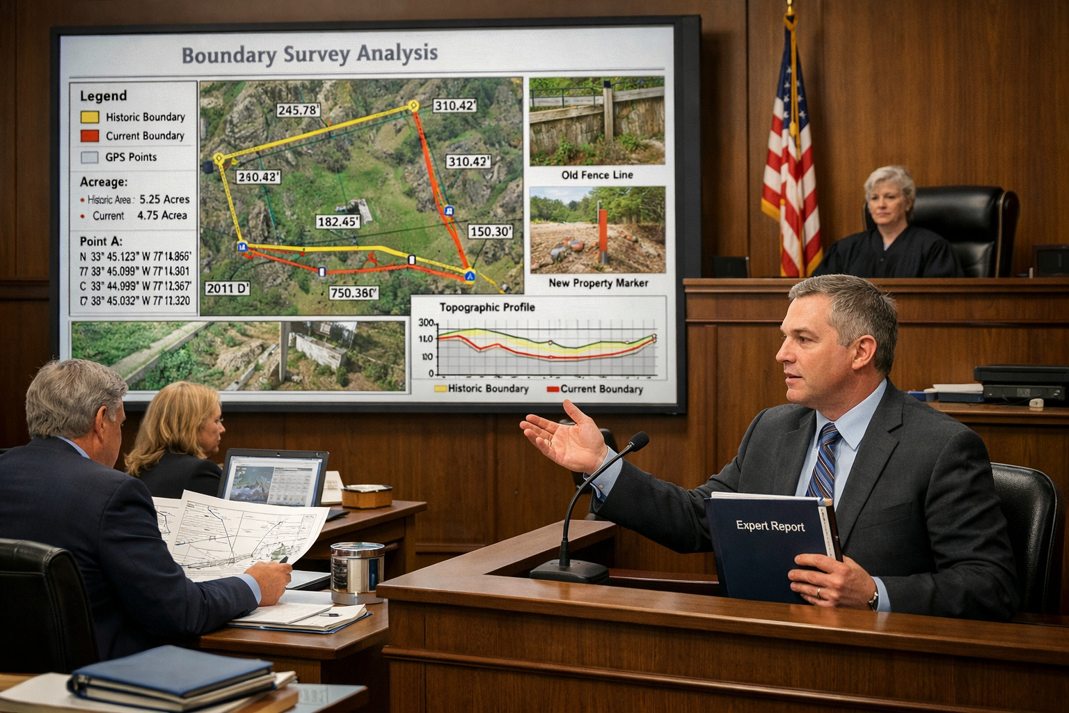
Modern expert witness reports incorporate visual evidence extensively. Annotated photographs, overlay comparisons showing historical vs. current positions, and 3D site models enhance judges' understanding of complex boundary relationships.
The Court Presentation Process
When boundary disputes proceed to trial, expert witness surveyors must present their evidence effectively under formal court procedures. The 2026 litigation environment emphasizes efficiency and clarity.
Typical court presentation sequence:
Pre-Trial Procedures 📋
- Exchange of expert reports with opposing party
- Joint expert meetings to narrow disputed issues
- Preparation of joint statements identifying agreements and disagreements
- Submission of supplementary reports addressing new evidence
- Pre-trial conferences with legal teams
Examination in Chief 🎤
- Qualification of expert by instructing solicitor/barrister
- Confirmation of report accuracy and currency
- Explanation of key findings for judge's benefit
- Presentation of visual evidence (plans, photographs, overlays)
- Clarification of technical terminology
Cross-Examination ⚖️
- Questioning by opposing counsel challenging methodology
- Testing of assumptions and alternative interpretations
- Probing qualifications and experience relevance
- Examination of potential bias or conflicts
- Challenge to measurement accuracy or evidence interpretation
Re-Examination and Judge's Questions 👨⚖️
- Clarification of points raised in cross-examination
- Judge's questions about technical aspects
- Final opportunity to reinforce key evidence
- Addressing any ambiguities or contradictions
The Charlton v Forrest ruling reminds expert witnesses that judges retain ultimate authority to determine boundary positions as matters of fact[1]. Even when both parties' experts agree, judges may reach different conclusions based on the totality of evidence. This reality emphasizes the importance of comprehensive evidence presentation rather than relying solely on technical surveying opinions.
Resolving Disputes Without Full Litigation: The Strategic Approach
Early Intervention and Alternative Dispute Resolution
While this article focuses on court evidence preparation, the most successful expert witness surveyors in 2026 resolve the majority of boundary disputes without trial. Strategic evidence compilation creates leverage for negotiated settlements and alternative dispute resolution.
Pre-litigation resolution pathways:
Negotiated Settlement 🤝
- Expert's preliminary opinion shared with both parties
- Evidence strength assessment encouraging realistic positions
- Facilitated discussions based on objective evidence
- Boundary agreement documentation and Land Registry registration
Mediation 🗣️
- Neutral mediator with expert surveyor as technical advisor
- Evidence presentation to both parties simultaneously
- Exploration of compromise solutions (e.g., boundary adjustments with compensation)
- Mediated settlement agreements avoiding court costs
Expert Determination 📊
- Parties agree to be bound by independent expert's decision
- Comprehensive evidence submission by both sides
- Expert's binding determination of boundary position
- Faster and less expensive than court proceedings
Boundary Agreement Registration 📝
- Parties agree precise boundary position based on expert evidence
- Formal boundary agreement prepared for Land Registry
- Determined boundary replaces general boundary on title plans
- Permanent resolution preventing future disputes
Statistics suggest that approximately 70-80% of boundary disputes involving expert witness surveyors settle before trial when comprehensive evidence is compiled early. The key lies in demonstrating evidence strength sufficiently to encourage realistic settlement positions.
Cost-Benefit Analysis: When to Engage Expert Surveyors
Property owners facing boundary disputes must weigh expert surveyor costs against potential litigation expenses and property value impacts.
Typical cost ranges (2026):
- Initial consultation and preliminary opinion: £500-£1,500
- Comprehensive boundary survey with basic research: £2,500-£5,000
- Full expert witness report with extensive historical research: £5,000-£12,000
- Court attendance and testimony: £2,000-£5,000 per day
- Full litigation costs (both sides): £25,000-£100,000+
When expert engagement is cost-effective:
✅ Disputed boundary affects significant property value (£20,000+ impact)
✅ Development plans depend on boundary position (extensions, new builds)
✅ Neighbor relationship breakdown requires objective evidence
✅ Historical evidence suggests strong case for your position
✅ Alternative resolution attempts have failed
When expert engagement may not be justified:
❌ Disputed area is minimal (under 1 meter with low property value impact)
❌ Relationship with neighbor allows informal resolution
❌ Cost exceeds property value impact significantly
❌ Historical evidence is clearly unfavorable
❌ Boundary position is genuinely ambiguous with weak evidence both sides
Professional surveyors providing services across locations from North London to Surrey offer initial consultations to assess evidence strength and likely outcomes before clients commit to full expert reports.
Common Boundary Dispute Scenarios and Evidence Strategies
Fence Line Disputes in Suburban Properties
Typical scenario: Neighboring property owners disagree about fence position, with one claiming encroachment of 0.5-2 meters.
Evidence strategy:
- Historical aerial photographs showing fence line consistency over decades[1]
- Original conveyance measurements from property corners to boundary
- Witness statements from long-term residents about fence installation and maintenance
- Physical evidence of previous fence posts or foundations
- Comparison of both properties' title plans and deed descriptions
Resolution approach: When aerial photography demonstrates fence stability for 20+ years with maintenance by one party, adverse possession claims or established boundary arguments become viable. Expert evidence often encourages settlement recognizing practical boundary positions.
Hedge and Natural Boundary Disputes
Typical scenario: Disagreement about whether boundary runs through hedge center, along one side, or at a different location entirely.
Evidence strategy:
- Conveyance language about "bounded by hedge" or similar descriptions
- Historical photographs showing hedge establishment and growth
- Root system investigation determining original planting location
- Ordnance Survey maps showing hedge position across multiple survey periods
- Expert opinion on hedge species, age, and likely planting pattern
Resolution approach: Natural boundaries require interpretation of historical conveyancing conventions (e.g., presumptions about hedge ownership and boundary position). Expert evidence clarifies these legal presumptions with physical evidence.
Party Wall and Shared Structure Disputes
Typical scenario: Disagreement about ownership and maintenance responsibilities for walls separating properties.
Evidence strategy:
- Title deed examination for party wall provisions
- Structural survey determining wall construction and foundations
- Historical building records and planning permissions
- Physical evidence of maintenance history (repairs, repointing)
- Party Wall Act notices and awards if applicable
Resolution approach: Party wall disputes often involve overlapping boundary and structural issues. Expert evidence clarifies ownership while Party Wall Act procedures address construction and maintenance rights.
Development and Extension Boundary Conflicts
Typical scenario: Proposed extension or development requires boundary certainty, but neighbor disputes position affecting development viability.
Evidence strategy:
- Precise survey measurements showing relationship between proposed development and boundary
- Planning permission requirements for boundary separation distances
- Historical evidence establishing boundary position pre-development
- Impact assessment if boundary position differs from assumptions
- Alternative design options if boundary determination affects feasibility
Resolution approach: Development pressure creates strong incentive for boundary resolution. Expert evidence combined with building surveyor services helps parties reach pragmatic solutions allowing development while protecting neighbor interests.
Rural and Agricultural Boundary Disputes
Typical scenario: Large-scale boundary disputes involving field boundaries, access routes, or water features.
Evidence strategy:
- Historical tithe maps and enclosure awards
- Aerial photography showing agricultural use patterns over decades[1]
- Conveyance descriptions referencing natural features (streams, hedgerows, ditches)
- Topographical surveys showing drainage and land form
- Agricultural subsidy records showing claimed field boundaries
Resolution approach: Rural disputes often involve substantial land areas making expert surveyor costs proportionate. Historical documentary evidence dating back centuries may be available, requiring specialized expertise in historical land records interpretation.
Technology Integration in Modern Boundary Dispute Resolution
Advanced Surveying Equipment and Techniques
Expert witness surveyors in 2026 employ sophisticated technology that produces evidence with unprecedented precision and visual clarity[2].
Key technologies:
GPS and GNSS Systems 🛰️
- Centimeter-level accuracy for boundary coordinate determination
- Integration with Ordnance Survey National Grid for consistent referencing
- Multi-constellation receivers (GPS, GLONASS, Galileo) for reliability
- Real-time kinematic (RTK) positioning for instant precision
Laser Scanning and 3D Modeling 📡
- Terrestrial laser scanners capturing complete site geometry
- Point cloud data showing all boundary features in three dimensions
- 3D models for courtroom visualization and evidence presentation
- Precise measurement extraction from scan data
Drone Aerial Photography 🚁
- High-resolution aerial imagery from multiple angles
- Orthophotography for accurate plan view representations
- Video documentation showing site context and relationships
- Comparison with historical aerial photographs at matching scales
Geographic Information Systems (GIS) 🗺️
- Integration of multiple evidence layers (historical maps, aerial photos, survey data)
- Overlay analysis showing boundary position across different evidence sources
- Spatial analysis of boundary relationships and measurements
- Professional cartographic presentation for court evidence
This technology produces evidence that is both highly accurate and visually compelling—essential for judges who must understand complex boundary relationships without technical surveying expertise.
Digital Evidence Management and Presentation
Modern expert witness surveyors maintain comprehensive digital evidence archives that support report preparation and court presentation.
Digital evidence systems include:
- Cloud-based document management with version control and audit trails
- Photographic databases with GPS tagging and timestamp verification
- CAD systems for precise boundary plan preparation and annotation
- Evidence presentation software for courtroom visual displays
- Secure evidence sharing platforms for legal team collaboration
The digital transformation enhances evidence credibility through demonstrable chain of custody, prevents document loss, and enables rapid response to court questions or supplementary evidence requests.
Legal Framework and Professional Standards in 2026
Civil Procedure Rules and Expert Witness Duties
Expert witness surveyors operate within strict legal frameworks governing expert evidence. The Civil Procedure Rules Part 35 establishes fundamental principles that override any party loyalty.
Core expert duties:
- Overriding duty to the court takes precedence over obligations to instructing party
- Independence and objectivity must be maintained regardless of who pays fees
- Expertise limitation requires experts to acknowledge matters outside their competence
- Factual basis for opinions must be clearly stated and verifiable
- Range of opinion should be expressed when evidence supports multiple interpretations
Violations of these duties can result in expert evidence being excluded, costs penalties, and professional disciplinary action. The Charlton v Forrest case demonstrates that even agreement between experts doesn't bind courts[1], emphasizing that experts must present evidence thoroughly rather than advocating for particular outcomes.
RICS Professional Standards for Boundary Disputes
The Royal Institution of Chartered Surveyors (RICS) publishes professional standards specifically addressing boundary disputes and expert witness work.
Key RICS guidance includes:
- Boundaries: Procedures for Boundary Identification, Demarcation and Dispute Resolution (professional standard)
- Surveyors Acting as Expert Witnesses (practice statement)
- Conflicts of Interest (professional statement)
- Professional Indemnity Insurance requirements for expert witness work
Chartered surveyors must comply with these standards as a condition of RICS membership. Clients seeking expert witness services should verify the surveyor's chartered status and specific experience with boundary dispute resolution.
Practical Steps for Property Owners Facing Boundary Disputes
Initial Assessment and Documentation
Before engaging expert surveyors, property owners can take preliminary steps to assess their position and gather basic evidence.
Recommended initial actions:
- Obtain Land Registry documents for both properties (title plans and registers)
- Photograph boundary features comprehensively from multiple angles
- Measure disputed area using basic tape measure from identifiable reference points
- Review property purchase documents for boundary descriptions or plans
- Document communication history with neighbor about boundary issues
- Check planning records for applications affecting boundary areas
- Identify potential witnesses who may have relevant knowledge
- Access Google Earth historical imagery showing boundary over time[1]
This preliminary work helps expert surveyors assess case strength during initial consultations and may reduce research time if formal engagement proceeds.
Selecting the Right Expert Witness Surveyor
Not all surveyors possess equal expertise in boundary disputes. Property owners should evaluate several factors when selecting expert witnesses.
Selection criteria:
Experience and Specialization 🎯
- Minimum 10+ years boundary dispute experience
- Track record of court testimony and accepted evidence
- Specific experience with dispute types similar to your case
- Knowledge of local area and property types
Professional Qualifications 📜
- Chartered status (MRICS/FRICS) with relevant specialization
- Professional indemnity insurance covering expert witness work
- CPD records demonstrating current knowledge
- Professional body memberships and accreditations
Communication and Approach 💭
- Clear explanation of process, timelines, and costs
- Realistic assessment of case strength and likely outcomes
- Responsiveness to questions and concerns
- Professional demeanor suitable for court presentation
Practical Considerations 💷
- Fee structure transparency (fixed fees vs. hourly rates)
- Availability for required timelines
- Geographic coverage and local knowledge
- References from previous clients or legal professionals
Consulting with solicitors experienced in property disputes can provide valuable recommendations for expert witness surveyors with proven court performance records.
Managing Costs and Expectations
Boundary dispute resolution involves significant costs that property owners should anticipate and budget appropriately.
Cost management strategies:
- Obtain detailed fee proposals with scope of work clearly defined
- Consider phased engagement (initial opinion before full expert report)
- Explore legal expense insurance coverage for dispute costs
- Assess settlement prospects at each stage before incurring additional costs
- Coordinate with legal team to avoid duplicated effort and fees
- Document all costs for potential recovery if successful in litigation
Realistic expectations about timelines and outcomes help property owners make informed decisions about dispute resolution strategies. Expert surveyors should provide honest assessments of evidence strength, including acknowledgment when evidence doesn't strongly support the client's preferred position.
Conclusion: Strategic Evidence Compilation Resolves Boundary Disputes
Boundary Disputes in 2026: When Expert Witness Surveyors Turn Land Registry Data into Court Evidence represents a sophisticated process combining historical research, modern surveying technology, and expert presentation skills. The Charlton v Forrest decision's emphasis on judicial independence in boundary determination[1] underscores the critical importance of comprehensive evidence compilation rather than relying solely on expert agreement.
Successful boundary dispute resolution depends on several key principles:
🔍 Evidence Quality Trumps Quantity – Courts value well-researched historical evidence, particularly aerial photographs and original conveyances, over Land Registry plans with inherent limitations.
⚖️ Early Expert Engagement Prevents Costly Litigation – Comprehensive evidence compiled early in disputes creates leverage for negotiated settlements, avoiding £25,000-£100,000+ litigation costs.
🎓 Specialized Expertise Matters – Professional licensing alone doesn't qualify surveyors as effective expert witnesses; courtroom experience and communication skills are equally essential.
📊 Technology Enhances Traditional Methods – Modern GPS, laser scanning, and GIS systems complement rather than replace historical research and site inspection fundamentals.
🤝 Objective Evidence Facilitates Resolution – Expert witness surveyors serving the court rather than advocating for parties help judges reach sound boundary determinations.
Next Steps for Property Owners
If you're facing a boundary dispute, take these actionable steps:
- Gather preliminary evidence using the initial documentation checklist provided above
- Consult with a specialist in boundary dispute resolution for case assessment
- Obtain realistic cost estimates for expert surveyor engagement and potential litigation
- Explore settlement options before committing to full litigation
- Engage qualified experts early to maximize evidence quality and settlement leverage
For complex disputes requiring court evidence, ensure your expert witness surveyor possesses demonstrated experience, appropriate qualifications, and the communication skills necessary for effective testimony. The investment in quality expert evidence typically pays dividends through stronger negotiating positions, higher settlement success rates, and better litigation outcomes when trials prove unavoidable.
Professional expert witness report preparation transforms raw Land Registry data, historical documents, and site measurements into compelling legal evidence that resolves boundary disputes efficiently and definitively.
References
[1] Qa What Evidence Can Establish Boundaries – https://www.charlesrussellspeechlys.com/en/insights/expert-insights/real-estate/2024/qa-what-evidence-can-establish-boundaries/
[2] Resolve Property Disputes Quickly With Expert Land Surveyors – https://www.andersoneng.com/resolve-property-disputes-quickly-with-expert-land-surveyors/
[3] Watch – https://www.youtube.com/watch?v=oiLAZiAr5Vs
[4] Top Five Common Property Boundary Disputes And How Surveys Resolve Them – https://hmsurveying.com/top-five-common-property-boundary-disputes-and-how-surveys-resolve-them/
[5] Was A Land Expert Essential In A Boundary Dispute – https://www.forensisgroup.com/resources/expert-legal-witness-blog/was-a-land-expert-essential-in-a-boundary-dispute
[6] Boundary Disputes Expert Witness – https://seakexperts.com/keywords/boundary-disputes-expert-witness