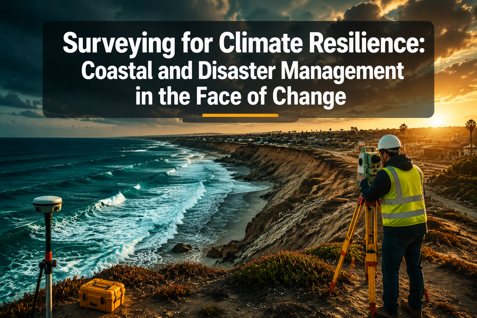
By 2050, more than one billion people worldwide could be living in low-elevation coastal zones directly threatened by rising seas — yet the surveying profession is only now catching up with what that truly means for how land, property, and infrastructure are assessed. Surveying for Climate Resilience: Coastal and Disaster Management in the Face of Change is no longer a niche concern for environmental scientists. It is a frontline discipline reshaping how chartered surveyors work, what data they collect, and how that data informs planning, insurance, and disaster recovery decisions.
Key Takeaways 📌
- Climate change is forcing surveyors to adopt new technologies — including LiDAR, drone surveys, and real-time monitoring — to track erosion, subsidence, and flood risk accurately.
- Coastal and disaster-zone surveys now require stricter regulatory compliance, with planning authorities demanding more detailed condition and risk assessments before approving development.
- A Schedule of Condition report is a critical tool for documenting a property's state before and after a climate-related event, protecting both owners and insurers.
- Subsidence and structural surveys are increasingly vital in flood recovery zones, where waterlogged ground and damaged foundations create long-term structural risk.
- Surveyors working in climate-vulnerable areas must understand evolving legislation, including flood risk assessments, coastal erosion policies, and environmental impact requirements.
Why Climate Change Is Rewriting the Surveyor's Rulebook
For most of the 20th century, a standard property or land survey assumed a relatively stable environment. Boundaries stayed put. Ground conditions changed slowly. Flood plains were mapped once and rarely revisited. That assumption is no longer safe.
💬 "The ground beneath our feet is changing faster than our survey records can keep pace with."
Sea levels around the UK coast are rising at an accelerating rate. Storm surges are more frequent and more intense. Inland flooding now affects communities that have never flooded before. Meanwhile, prolonged dry spells are causing clay shrinkage and subsidence in ways that are triggering a new wave of structural damage claims across the country.
For surveyors, this creates a dual challenge:
- Pre-event assessment — accurately mapping risk before disaster strikes
- Post-event recovery — documenting damage and guiding safe rebuilding
Both require a significant upgrade in technique, technology, and regulatory awareness.
The Shift From Static to Dynamic Surveying
Traditional surveys produced a snapshot: a fixed record of a property or piece of land at a single point in time. Climate resilience demands something different — dynamic, repeatable surveys that track change over time.
This is especially true in coastal zones, where cliff faces can retreat by metres in a single winter storm, and in river floodplains, where ground levels shift with every major flood event. Surveyors are now expected to provide not just measurements but trend data — evidence of how a site is changing and at what rate.
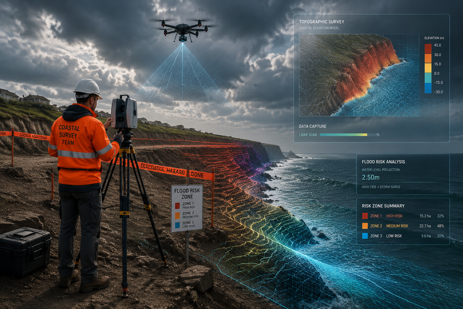
New Survey Technologies Driving Climate Resilience Work
LiDAR and Drone Surveys: Seeing the Invisible
One of the most significant shifts in surveying for climate resilience has been the adoption of LiDAR (Light Detection and Ranging) technology. LiDAR uses laser pulses to generate highly accurate 3D models of terrain, buildings, and coastlines. It can detect millimetre-level changes in ground elevation — exactly the kind of data needed to track erosion and subsidence.
Paired with drone technology, LiDAR surveys can cover large areas quickly and safely, including locations that are too dangerous for surveyors to access on foot. A drone roof survey uses similar aerial imaging principles to inspect hard-to-reach structures — and the same logic applies to coastal cliffs, flood-damaged rooflines, and unstable embankments.
Key benefits of drone-assisted climate surveys:
| Technology | Application | Advantage |
|---|---|---|
| LiDAR scanning | Coastal erosion mapping | Millimetre accuracy over large areas |
| Drone photogrammetry | Post-flood damage assessment | Safe access to unstable zones |
| Thermal imaging | Moisture penetration in flood-hit buildings | Identifies hidden damp and structural risk |
| GPS/GNSS monitoring | Ground movement tracking | Real-time subsidence alerts |
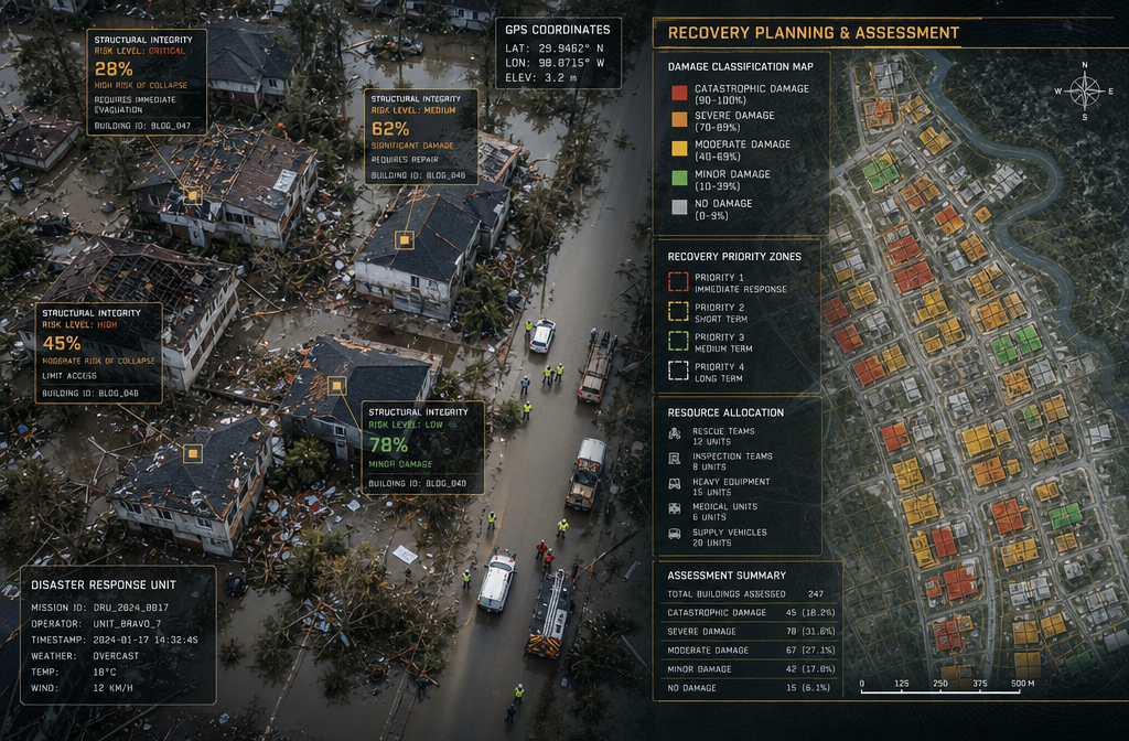
Subsidence Surveys in a Changing Climate 🏗️
As drought cycles become more common, clay soil shrinkage is causing subsidence in properties that were previously considered stable. This is particularly acute in areas of London and the South East, where large areas of shrinkable clay underlie millions of homes.
A subsidence survey is now increasingly recommended not just when visible cracking appears, but as a precautionary measure in high-risk zones. Surveyors assess crack patterns, monitor movement over time, and advise on whether underpinning or other remedial action is needed.
The same applies in reverse: waterlogged ground following flooding can cause heave — where saturated soil expands and pushes upward, cracking foundations and walls. Post-flood structural surveys are essential before any property is reoccupied.
Coastal and Disaster Management: What Surveyors Must Assess
Flood Risk and Coastal Erosion Assessments
Surveying for Climate Resilience: Coastal and Disaster Management in the Face of Change demands that surveyors understand flood risk at a granular level. The Environment Agency's flood zone classifications (Zones 1, 2, and 3 in England) provide a starting framework, but climate change is already making these maps outdated in some areas.
Surveyors working in coastal and flood-prone areas must now consider:
- Predicted sea level rise over the lifetime of a development
- Coastal erosion rates — how quickly land is being lost to the sea
- Tidal surge modelling — the risk of extreme high-water events
- Groundwater flooding — often overlooked but increasingly common
- Surface water drainage capacity — critical in urban flash flood scenarios
💡 Key fact: The UK's National Flood Risk Assessment (NaFRA2) released updated risk data in 2023, showing that millions more properties face significant flood risk than previously estimated.
For properties near the coast or in river floodplains, a structural survey should always include an assessment of how flood risk may affect the building's foundations, damp-proofing, and long-term structural integrity.
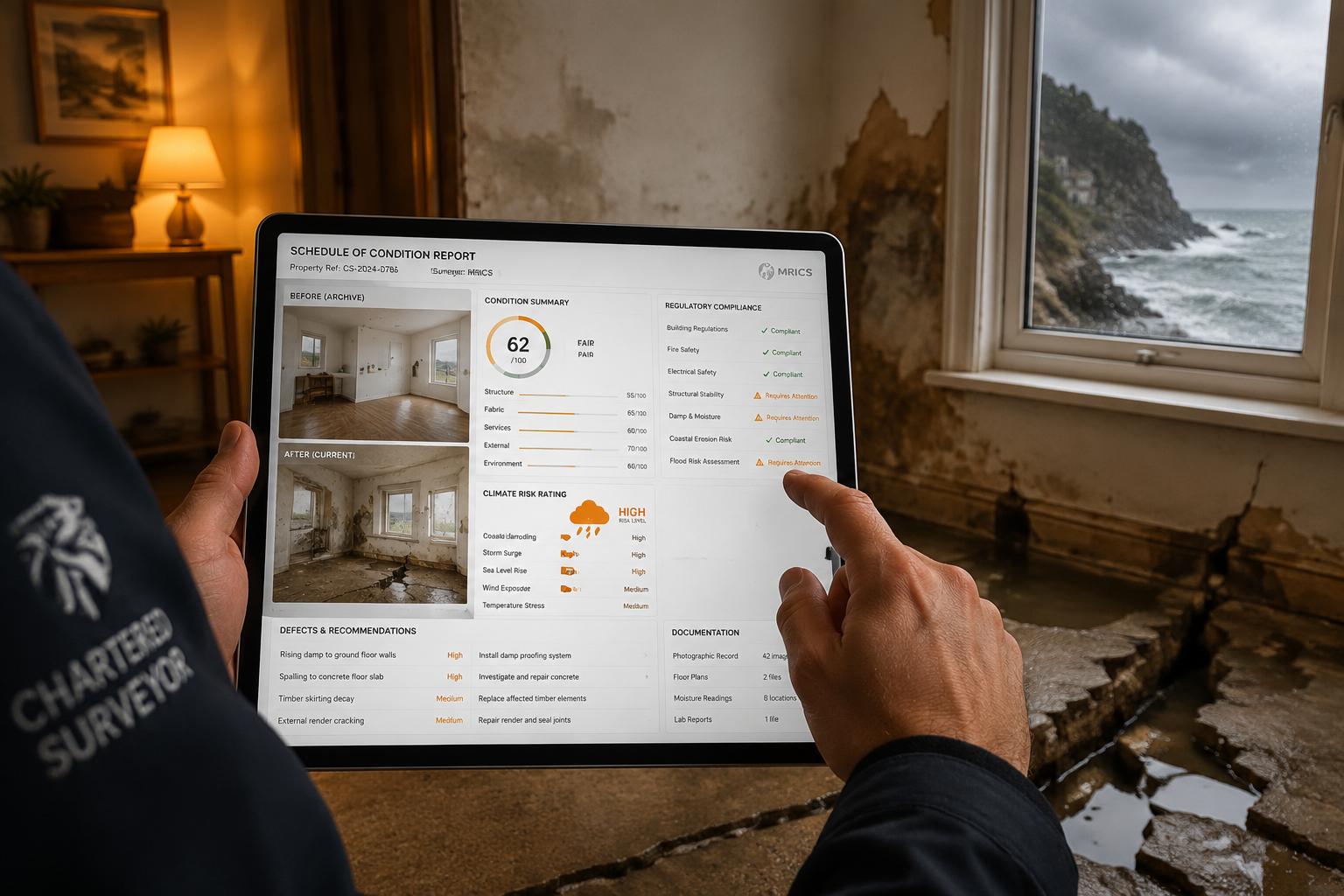
Schedule of Condition Reports: The Climate Resilience Safety Net
One of the most underused but critically important tools in disaster management surveying is the Schedule of Condition report. This document creates a detailed, timestamped photographic and written record of a property's condition at a specific point in time.
In the context of climate resilience, a Schedule of Condition report serves several vital functions:
- Pre-flood baseline — documents the property before a flood event, making insurance claims and damage assessments far more straightforward
- Post-disaster comparison — provides clear evidence of what damage was caused by the event versus pre-existing issues
- Legal protection — protects property owners, landlords, and tenants in disputes about responsibility for climate-related damage
- Planning applications — increasingly required by local authorities in flood risk areas before development consent is granted
Stricter Regulations: What the Law Now Demands
The regulatory landscape for development in climate-vulnerable areas has tightened considerably. In England, the National Planning Policy Framework (NPPF) requires a Sequential Test and, where necessary, an Exception Test for any development in flood risk areas. Failure to provide adequate flood risk assessments can result in planning refusal.
Beyond planning, building regulations now incorporate stricter requirements for:
- Flood-resilient construction in Flood Zone 2 and 3 areas
- Sustainable drainage systems (SuDS) for new developments
- Coastal change management areas where development is restricted near eroding coastlines
Surveyors must be fluent in these requirements. Understanding what survey you need in a climate-sensitive context is the first step — but knowing which regulatory frameworks apply is equally important.
Surveying for Climate Resilience: Coastal and Disaster Management Across Different Property Types
Residential Properties in Flood Zones
For homeowners and buyers, the stakes are intensely personal. A property that floods once can lose significant value and become difficult to insure. The best London property valuation guide highlights how flood risk is increasingly factored into formal valuations — and rightly so.
What a climate-aware residential survey should cover:
- ✅ Flood zone classification and historical flood records
- ✅ Evidence of previous flood damage (tide marks, replaced plasterwork, raised electrical sockets)
- ✅ Condition of damp-proof courses and flood barriers
- ✅ Drainage and surface water management
- ✅ Foundation type and vulnerability to waterlogging or subsidence
- ✅ Roof condition — storm damage risk assessment
A roof survey is particularly relevant in coastal areas, where salt spray, high winds, and storm damage accelerate roof deterioration at rates far higher than inland properties.
Commercial and Infrastructure Properties
Commercial properties in flood-prone areas face additional complexity. Business interruption, tenant liability, and the cost of flood-resilient retrofitting all feed into valuation and risk assessments. A dilapidation survey becomes especially important when tenants vacate flood-damaged premises and disputes arise over who is responsible for repairs.
For infrastructure — bridges, sea walls, coastal roads — specialist engineering surveys using ground-penetrating radar, drone inspection, and real-time monitoring are now standard practice in climate resilience planning.
Building a Climate-Resilient Survey Practice
Skills and Training for the Modern Climate Surveyor
The chartered surveyor of 2026 needs a broader skill set than ever before. Beyond traditional measurement and assessment, climate resilience work demands:
- Environmental literacy — understanding flood modelling, erosion science, and climate projections
- Technology proficiency — operating and interpreting data from drones, LiDAR, and monitoring sensors
- Regulatory knowledge — staying current with planning policy, building regulations, and environmental law
- Communication skills — translating complex risk data into clear advice for clients, insurers, and planners
Professional bodies including RICS (Royal Institution of Chartered Surveyors) have responded by developing new guidance and competency frameworks specifically for climate risk and resilience surveying.
The Role of Data and Collaboration
No single surveyor can hold all the data needed for effective climate resilience work. The most effective approach involves collaboration between:
- Chartered surveyors
- Environmental consultants
- Local planning authorities
- The Environment Agency
- Insurance underwriters
- Structural engineers
Residential structural engineers play a particularly important role in post-disaster assessment, working alongside surveyors to determine whether flood or storm-damaged buildings are safe to reoccupy and what remedial work is required.
Boundary Surveys in Eroding Coastal Zones
Coastal erosion creates a uniquely complex legal and practical challenge: land boundaries literally disappear into the sea. This has implications for property ownership, planning permissions, and liability.
Boundary surveys in coastal erosion zones require specialist knowledge of both surveying technique and property law. As coastlines retreat, previously agreed boundaries may no longer correspond to any physical feature on the ground, creating disputes that require careful expert resolution.
Conclusion: Actionable Steps for Surveyors and Property Owners
Surveying for Climate Resilience: Coastal and Disaster Management in the Face of Change is not a future concern — it is an immediate professional and practical reality in 2026. The combination of accelerating climate impacts, stricter regulations, and rising public awareness means that surveyors who develop genuine expertise in this area will be in high demand.
Actionable Next Steps 🎯
For property owners and buyers:
- Commission a climate-aware survey before purchasing any property in a flood zone or coastal area — not just a standard valuation.
- Request a Schedule of Condition report before and after any significant weather event to protect your insurance position.
- Check your property's flood zone status using the Environment Agency's flood map and discuss implications with a chartered surveyor.
For surveyors:
- Invest in drone and LiDAR training — these technologies are becoming standard, not optional, in climate resilience work.
- Stay current with planning policy — the NPPF and Environment Agency guidance are updated regularly, and compliance knowledge is a key differentiator.
- Build collaborative networks with structural engineers, environmental consultants, and insurers to offer comprehensive climate risk assessments.
- Document everything — in an era of increasing climate-related disputes, thorough, timestamped survey records are invaluable.
The surveying profession has always been about understanding the ground beneath our feet. In an era of climate change, that ground is shifting — and the surveyors who adapt fastest will be the ones who help communities, property owners, and planners navigate what comes next.