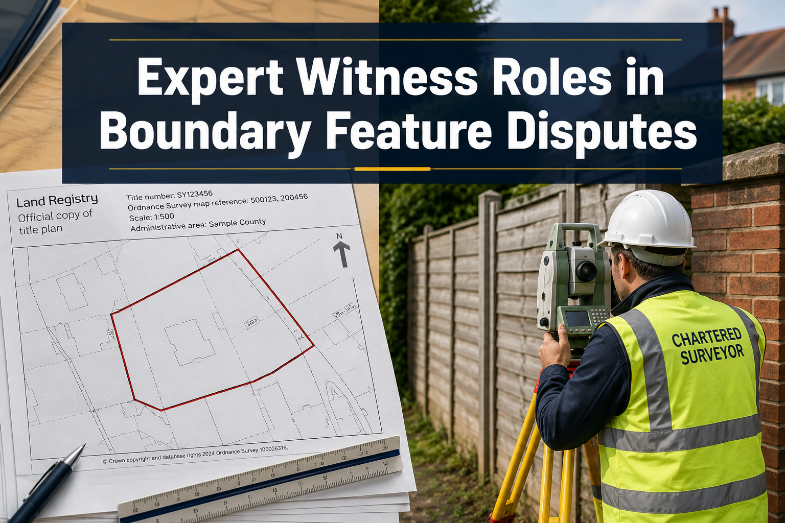
Boundary disputes are among the most bitterly contested property matters in England and Wales — and yet the document at the centre of almost every case, the Land Registry title plan, carries a legal disclaimer warning that it is not drawn to a standard sufficient to determine exact boundary positions. That single contradiction drives thousands of neighbour conflicts to court each year, and it is precisely why expert witness roles in boundary feature disputes — turning Land Registry plans into admissible survey evidence — have become one of the most technically demanding and legally scrutinised areas of chartered surveying practice in 2026.
Understanding how a surveyor moves from a 1:1250 Ordnance Survey-based title plan to a CPR Part 35-compliant expert report is essential knowledge for property owners, solicitors, and surveyors alike. This article provides a step-by-step guide to that process, covering measured surveys, photogrammetry, report structure, and the professional standards that determine whether evidence stands or falls in court.
Key Takeaways
- Land Registry title plans are indicative, not definitive — they cannot alone determine exact boundary positions, making expert surveyor evidence essential.
- CPR Part 35 sets strict requirements for expert reports; non-compliance can render even technically sound evidence inadmissible.
- Measured surveys and drone photogrammetry together provide the most defensible evidential foundation for fence and wall ownership disputes.
- A qualified expert witness owes their primary duty to the court, not to the instructing party — this impartiality is non-negotiable.
- RICS updated its professional standard on boundary identification and dispute resolution, reinforcing the distinction between advisory and expert witness roles.

Why Land Registry Plans Cannot Stand Alone in Boundary Disputes
Every registered title in England and Wales is accompanied by a title plan based on Ordnance Survey mapping. These plans use a general boundary rule: they show the general position of a boundary, not its precise legal line. At a scale of 1:1250 in urban areas, a line width on the plan can represent up to 500 mm on the ground — enough to encompass an entire fence post, a garden wall, or even a narrow strip of land worth tens of thousands of pounds.
This is not a flaw in the system; it is a deliberate design choice reflecting the fact that the Land Registry registers ownership of estates, not physical features. However, when neighbours dispute whether a fence, wall, or hedge sits on one side of a boundary or the other, that general boundary is wholly inadequate as evidence.
Common boundary features at the heart of disputes include:
| Feature | Typical Dispute | Key Evidential Challenge |
|---|---|---|
| Timber fence | Ownership and maintenance liability | Which side carries the posts? |
| Brick or block wall | Encroachment onto neighbour's land | Footings and foundation position |
| Hedge and ditch | Historic boundary presumption | Age and original planting line |
| Retaining wall | Ownership of substructure | Ground level differential evidence |
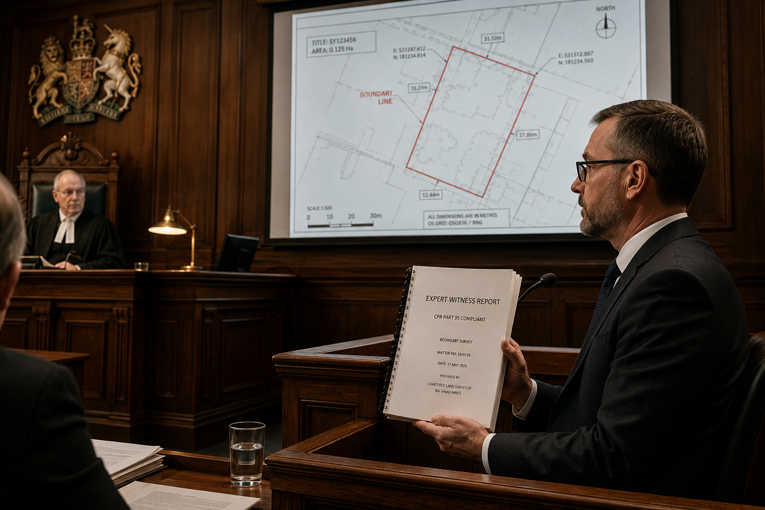
Courts require expert opinion to bridge the gap between the general boundary shown on a title plan and the precise physical position of a feature on the ground [1]. That expert opinion must be grounded in a rigorous, documented survey methodology — and it must comply with Civil Procedure Rules Part 35 to be admissible.
For those involved in disputes across the capital and surrounding regions, boundary surveys in London represent the starting point for building a defensible evidential record.
Step-by-Step: From Measured Survey to Expert Report
Step 1 — Initial Instructions and Scope Definition
Before any fieldwork begins, the expert must receive clear written instructions defining the scope of the commission. Under CPR Part 35, the expert report must state the instructions received and confirm that the expert understands their overriding duty to the court [3].
A well-scoped instruction will specify:
- The title numbers of all properties involved
- The specific boundary features in dispute
- The questions the expert is asked to address
- Any documents already disclosed by both parties
This stage also requires the expert to assess whether the dispute falls within their area of competence. An expert who oversteps their expertise risks having their evidence challenged or excluded entirely [5].
Step 2 — Documentary Evidence Review
Before setting foot on site, the expert assembles and analyses all available documentary evidence. This typically includes:
- Land Registry title plans and registers for all affected titles
- Conveyance plans from the pre-registration era, which often carry more detail than modern title plans
- Ordnance Survey historical maps, particularly 1:2500 County Series editions dating from the late 19th and early 20th centuries
- Aerial photographs from the National Collection, which can show boundary feature positions across decades
- Planning applications and approved drawings that may reference boundary positions
- Deeds, transfers, and any express boundary agreements
The analysis of historical OS maps is particularly powerful. A surveyor who can demonstrate that a fence line has remained in the same position across multiple OS revisions builds a compelling case for the physical boundary's location — even where the title plan is ambiguous [4].
Step 3 — The Measured Survey
The measured survey is the technical foundation of the expert's evidence. It must be conducted to a standard that allows the results to be reproduced and independently verified.
Recommended equipment and methods include:
- Total station or robotic total station — provides sub-centimetre accuracy for recording the position of boundary features, building lines, and datum points
- GNSS/GPS survey-grade receivers — used to tie the survey to the National Grid, allowing direct comparison with OS mapping
- 3D laser scanning — captures complex features such as retaining walls, stepped boundaries, and overlapping structures with millimetre precision
- Traditional tape and offset measurements — still valid for simple linear boundaries and useful as a cross-check
The survey must record not just the current position of the disputed feature, but also all adjacent fixed structures — building corners, manhole covers, kerb lines — that can serve as independent reference points. This allows the court to verify the survey's accuracy without relying solely on the expert's word.
All field notes, instrument readings, and calibration records should be retained as part of the expert's working file. Courts increasingly expect experts to disclose their methodology in full [3].
Step 4 — Photogrammetry and Drone Survey Evidence
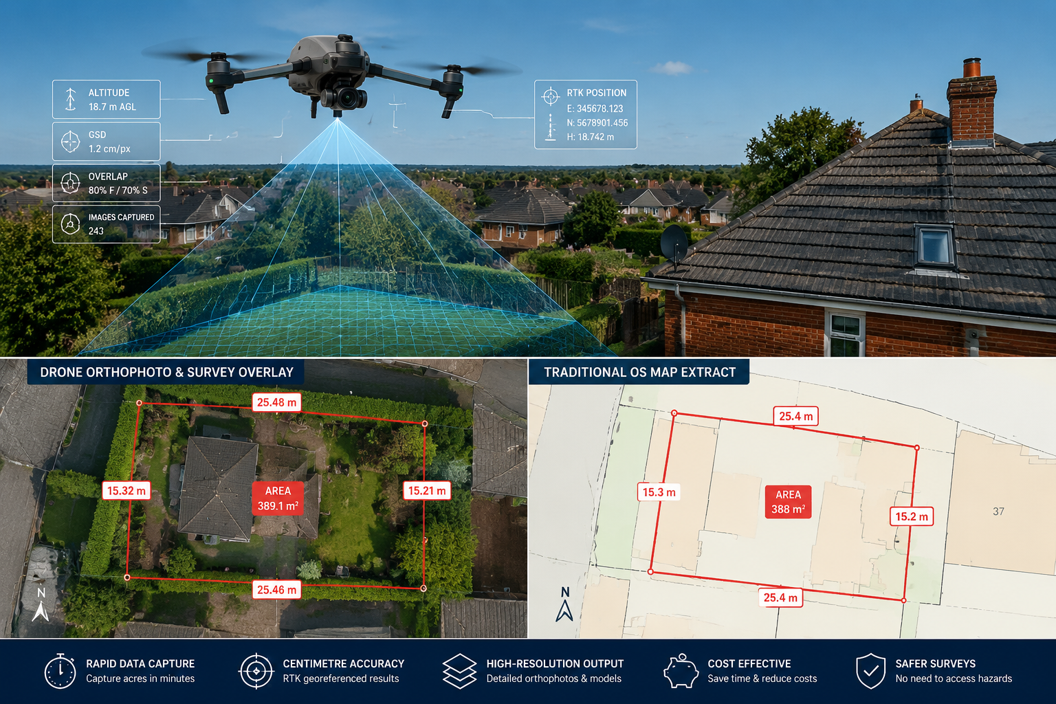
The use of drone technology in boundary disputes has accelerated significantly in 2026. Unmanned aerial vehicles equipped with high-resolution cameras and RTK (Real-Time Kinematic) GPS receivers can produce orthophotographs and 3D point clouds that are geometrically corrected to centimetre accuracy [2].
Why photogrammetry strengthens expert evidence:
- It provides a visual record of the site at a specific date and time, which can be critical if features are subsequently altered
- Orthophotos can be overlaid directly onto OS mapping and title plans, making the spatial relationship between features immediately visible to a judge
- 3D models allow the court to understand complex topography — slopes, retaining structures, and level changes — that flat plans cannot convey
- The data is objective and reproducible; another surveyor can verify the findings independently
For disputes involving larger plots or rural boundaries, drone surveys are now considered best practice rather than an optional enhancement [2]. Surveyors providing expert surveyor advice on complex boundary matters will typically recommend photogrammetric capture as a standard component of the evidence-gathering process.
Ground control points (GCPs) must be established using total station or GNSS equipment before the drone flight. These GCPs are used to georeference the photogrammetric model, and their coordinates must be reported in the expert's methodology section.
Step 5 — Analysis and Opinion Formation
With the measured survey data, photogrammetric outputs, and documentary evidence assembled, the expert can begin the analytical phase. This involves:
- Scaling and comparing — plotting the measured survey results onto the title plan at a consistent scale, noting any discrepancies
- Applying boundary presumptions — where the documentary evidence is ambiguous, established legal presumptions (such as the hedge and ditch rule, or the T-mark convention) may assist in forming an opinion
- Assessing physical evidence — the position of fence posts, the ownership of wall faces, the direction of coping stones, and the position of footings all provide physical clues to the intended boundary
- Forming a reasoned opinion — the expert must be able to articulate, clearly and without advocacy language, where the boundary most probably lies and why
Expert opinion on the "ultimate issue" — that is, the actual legal boundary position — is admissible in boundary disputes where it genuinely assists the court [8]. However, the expert must distinguish between what the physical evidence shows and what the legal conclusion should be; the latter remains a matter for the judge.
Step 6 — Structuring the CPR Part 35 Compliant Report
The expert report is the product that will be scrutinised by the court, the opposing party, and their legal teams. A report that fails to comply with CPR Part 35 and Practice Direction 35 risks being struck out or given reduced weight [3].
A compliant expert report must include:
| Section | Required Content |
|---|---|
| Expert's qualifications | MRICS/FRICS status, relevant experience, specialist expertise |
| Instructions received | Verbatim or summarised instructions, date received |
| Scope of the report | What questions are addressed and what is excluded |
| Documents reviewed | Full list of all evidence considered |
| Site inspection details | Date, time, weather, who was present, access obtained |
| Methodology | Equipment used, calibration records, survey methods |
| Factual findings | Measurements, observations, photographic evidence |
| Expert opinion | Reasoned conclusion, expressed with appropriate certainty |
| Statement of truth | Mandatory declaration under CPR 35.3 |
The statement of truth is not a formality. It confirms that the expert understands their duty to the court, that the report is their genuine opinion, and that they have not omitted material facts that would affect their conclusions [3].
Common Pitfalls That Undermine Expert Evidence in Boundary Disputes
Even technically excellent survey work can be rendered ineffective if the expert report contains avoidable errors. Research into boundary dispute litigation has identified several recurring problems [4]:
Advocacy language — phrases such as "it is clear that" or "the claimant is obviously correct" signal that the expert has adopted a partisan position. Courts treat such language as a red flag.
Incomplete methodology disclosure — failing to explain how measurements were taken, what equipment was used, or how the data was processed leaves the report open to challenge on the basis that it cannot be independently verified.
Missing or defective declarations — the absence of a CPR 35.3 statement of truth, or a statement that does not address all required elements, is a technical defect that opposing counsel will exploit.
Selective data presentation — presenting only the measurements that support one party's case, while omitting data that points the other way, is a serious professional failing that can result in disciplinary action by RICS as well as adverse findings by the court.
Overstating certainty — boundary evidence is rarely conclusive. An expert who claims absolute certainty where the evidence is genuinely ambiguous will lose credibility under cross-examination.
The RICS professional standard updated in 2026 reinforces that surveyors must maintain a clear distinction between their role as a boundary identification adviser and their role as a court-appointed or party-appointed expert witness [1]. These are different functions with different duties, and conflating them undermines the integrity of both.
For disputes that also involve shared structures, understanding the overlap with party wall disputes is important, as the same boundary feature may simultaneously engage both boundary law and the Party Wall etc. Act 1996.
Single Joint Experts and Party-Appointed Experts
In lower-value boundary disputes, courts often direct the parties to use a Single Joint Expert (SJE) rather than each appointing their own surveyor [2]. The SJE is instructed jointly by both parties and owes an equal duty to each — and to the court. This arrangement reduces costs and eliminates the adversarial dynamic that can arise when two experts reach diametrically opposed conclusions.
Key differences between SJE and party-appointed expert roles:
- An SJE answers questions from both parties and the court; a party-appointed expert answers primarily to their instructing solicitor (subject always to the overriding duty to the court)
- An SJE's report is usually the only expert evidence before the court; party-appointed experts may produce sequential reports and a joint statement of agreed and disputed issues
- Courts in the County Court are increasingly directing SJE appointments in boundary cases where the disputed strip has a value below a threshold that would justify the cost of dual expert evidence [2]
Where parties do each appoint their own expert, those experts are required to meet (either in person or remotely) and produce a joint statement identifying the issues on which they agree and those on which they disagree, with reasons. This joint statement often narrows the issues significantly before trial and can facilitate settlement.
Solicitors and property owners seeking specialist support can find chartered surveyors in London and across the wider region who are experienced in both SJE and party-appointed expert roles. Those in the home counties can also access chartered surveyors in Surrey and chartered surveyors in Hertfordshire with relevant boundary dispute expertise.
Qualifications and Professional Standards for Expert Witnesses
Not every chartered surveyor is qualified to act as an expert witness in boundary disputes. The role demands a specific combination of technical skills, legal knowledge, and professional standing [5].
Minimum qualifications and attributes expected by courts:
- Chartered status — MRICS or FRICS membership of the Royal Institution of Chartered Surveyors
- Relevant specialism — demonstrable experience in boundary surveying, not merely general practice
- Knowledge of historical surveying methods — ability to interpret and scale pre-metric maps, understand different datum systems, and recognise the limitations of historical OS editions
- Proficiency with modern survey technology — total station, GNSS, laser scanning, and drone photogrammetry
- Understanding of CPR Part 35 — familiarity with the procedural rules governing expert evidence, including Practice Direction 35 and the Protocol for the Instruction of Experts
Several directories now list qualified expert witnesses specialising in land surveying and boundary disputes, providing solicitors with a structured way to identify and evaluate potential appointments [6]. Expert witnesses in this field provide critical insights, detailed evaluations, and courtroom-defensible testimony across a wide range of property line disputes, easement claims, and encroachment cases [7].
Those involved in boundary disputes resolution should verify that any proposed expert can demonstrate both the technical credentials and the procedural knowledge required to produce a report that will withstand scrutiny at trial.
Conclusion
Expert witness roles in boundary feature disputes — turning Land Registry plans into admissible survey evidence — sit at the intersection of technical surveying practice and civil litigation procedure. The process is demanding, but it follows a clear and reproducible methodology: assemble documentary evidence, conduct a precision measured survey, apply photogrammetric techniques where appropriate, and structure the resulting report in strict compliance with CPR Part 35.
Actionable next steps for property owners and solicitors:
- Obtain all title documents early — gather title plans, historic conveyances, and any planning drawings before instructing a surveyor, as these shape the scope of the expert's commission.
- Instruct a chartered surveyor with demonstrable boundary dispute experience — MRICS or FRICS status is a minimum; ask specifically about CPR Part 35 experience and previous court appointments.
- Consider drone photogrammetry as standard — for any dispute involving a boundary longer than approximately 20 metres, or where topography is complex, aerial photogrammetric evidence adds significant weight to the expert's report.
- Request a clear methodology statement — before committing to an expert, ask how they will document their survey process and how their data can be independently verified.
- Explore Single Joint Expert appointment — in lower-value disputes, agreeing on an SJE at an early stage can reduce costs substantially and often produces a faster resolution.
The gap between a general boundary on a title plan and a defensible position in court is bridged by rigorous survey methodology, professional impartiality, and procedural compliance. Getting those three elements right is what separates expert evidence that resolves disputes from evidence that simply prolongs them.
References
[1] Boundaries procedures for boundary identification, demarcation and dispute resolution – https://www.rics.org/content/dam/ricsglobal/documents/standards/Boundaries%2520procedures%2520for%2520boundary%2520identification_%2520demarcation%2520and%2520dispute%2520resolution_October%25202022.pdf
[2] Expert Witness Roles In CPR Part 35 Boundary Disputes Turning Drone Surveys Into Courtroom Evidence 2026 – https://kingstonsurveyors.com/expert-witness-roles-in-cpr-part-35-boundary-disputes-turning-drone-surveys-into-courtroom-evidence-2026/
[3] Expert Witness Surveyors In Neighbour Boundary Disputes RICS Standards Vs Land Registry Evidence – https://www.canterburysurveyors.com/blog/expert-witness-surveyors-in-neighbour-boundary-disputes-rics-standards-vs-land-registry-evidence/
[4] Expert Witness Surveyors In Boundary And Access Disputes What Evidence Courts Expect Beyond Title Plans – https://kingstonsurveyors.com/expert-witness-surveyors-in-boundary-and-access-disputes-what-evidence-courts-expect-beyond-title-plans/
[5] Boundary Disputes In 2026 When Expert Witness Surveyors Turn Land Registry Data Into Court Evidence – https://kingstonsurveyors.com/boundary-disputes-in-2026-when-expert-witness-surveyors-turn-land-registry-data-into-court-evidence/
[6] Land Registry Expert Witness Directory – https://www.jspubs.com/expert-witness/si/l/land-registry/
[7] Surveying Expert Witness Services – https://www.forensisgroup.com/forensis-expert-witness/expertise/surveying
[8] Expert Opinion In Boundary Disputes – https://acornrpc.co.uk/expert-opinion-in-boundary-disputes/3/