{"cover":"Professional landscape format (1536×1024) hero image with bold text overlay 'GPS in Boundary Disputes and Party Wall' in crisp white sans-serif on a dark semi-transparent panel, centered with 8% safe margins from every edge. Background: aerial editorial photograph of a British residential street with terraced houses, a surveyor in high-visibility vest holding a GNSS rover pole on a property boundary, bright daylight, overhead drone perspective showing garden fence lines and party walls, teal and navy color grade, magazine cover aesthetic, high contrast, editorial quality.","content":["Numbered four-step annotated process flow diagram on a clean white background with navy and teal palette. Step 1: 'Base Station Setup', illustration of a GPS base receiver on a tripod at a known benchmark. Step 2: 'GNSS Rover Survey', surveyor with rover pole at a boundary marker. Step 3: 'Coordinate Processing', laptop screen showing least-squares adjustment output with grid coordinates. Step 4: 'Legal Plan Production', formal boundary plan with bearings, distances, and coordinate table. Each step connected by arrows, short callout labels (1-5 words each) pointing to key elements, all labels inside 5% safe margin, editorial infographic style.","Split-screen landscape format (1536×1024) editorial comparison. Left panel labeled 'Old Title Deed Plan' showing a faded hand-drawn property boundary sketch on yellowed paper with vague measurements and no coordinate references. Right panel labeled 'GPS Coordinate Survey' showing a modern digital cadastral plan with GNSS-derived grid coordinates, precise bearings, and coloured boundary lines on a clean white background. A bold vertical dividing line separates the panels. Short callout labels on each side: left, 'No datum reference', 'Approximate scale', 'Ambiguous features'; right, 'National grid tie', 'Sub-centimetre accuracy', 'Court-admissible'. Navy and amber palette, high-contrast editorial quality.","Annotated documentary-style editorial photograph (1536×1024) taken at ground level of a party wall between two London semi-detached properties. A female South Asian surveyor in a hard hat and high-visibility vest holds a GNSS rover pole directly against the party wall face, with a total station instrument visible in the background. Overlaid callout lines point to: 'Party wall centre line', 'GNSS rover antenna', 'Boundary peg at foundation', 'Coordinate data logger'. Warm daylight, shallow depth of field on the background, teal and white callout style, professional editorial quality, all labels inside 5% safe margin."]
Boundary disputes cost English and Welsh property owners an estimated tens of millions of pounds each year in legal fees, yet many of those conflicts originate from plans drawn to a scale of 1:1250 where a pencil line represents up to 1.25 metres on the ground. That single fact explains why GPS in boundary disputes and party wall evidence, and the modern coordinate systems that underpin it, has moved from a specialist curiosity to a mainstream legal tool. When older title deeds and physical features do not align, precise satellite-derived coordinates can be the deciding factor in court.
Key Takeaways
- GPS and GNSS technology now provides sub-centimetre positional accuracy, making it far more reliable than scaled title deed plans for resolving boundary and party wall disputes.
- Courts in multiple jurisdictions have accepted properly conducted GNSS surveys as valid technical evidence, provided the work meets defined accuracy standards and is fully documented.
- GPS coordinates supplement, but do not replace, traditional evidence such as title deeds, physical monuments, and witness statements.
- Party wall surveyors increasingly use coordinate-based measurements to establish wall positions and thicknesses when the boundary alignment is disputed.
- Instructing a qualified chartered surveyor early in a dispute reduces costs and strengthens the evidentiary record before litigation begins.
Why Traditional Plans Fail and GPS Steps In
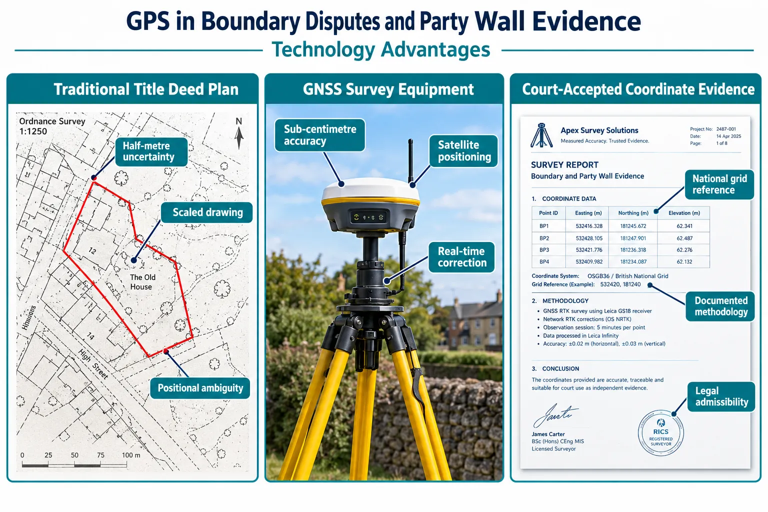
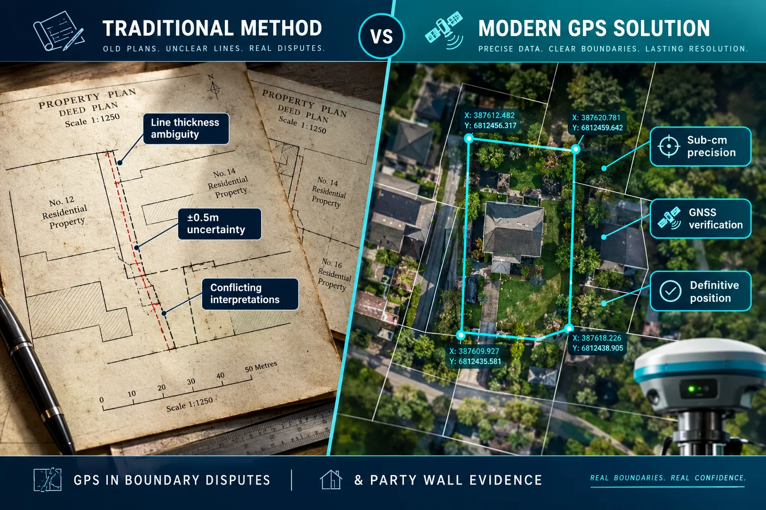
For most of the twentieth century, property boundaries in England and Wales were recorded on Ordnance Survey base maps at scales that were never designed for precise legal demarcation. A line drawn at 1:1250 carries an inherent positional uncertainty of roughly half a metre on each side. When two neighbours measure from that same line to determine who owns a strip of land, they can arrive at genuinely different answers, both correct within the plan's tolerance, and still end up in dispute.
Physical features compound the problem. Fences move. Hedges grow outward by 150 mm per decade. Walls are rebuilt slightly off their original line. Over thirty or forty years, these small shifts accumulate into discrepancies that no amount of re-reading the original deed will resolve.
This is precisely where GPS in boundary disputes and party wall evidence delivers its greatest value. A Global Navigation Satellite System (GNSS) receiver, GPS is the American constellation, but modern equipment also uses European Galileo, Russian GLONASS, and Chinese BeiDou signals, can determine a position on the surface of the earth to within a few millimetres when used in differential or Real-Time Kinematic (RTK) mode. That level of accuracy is orders of magnitude better than any scaled plan.
A 2026 practice analysis confirms that GNSS receivers and high-accuracy digital mapping tools such as Ordnance Survey MasterMap have become vital instruments in property litigation, providing precise positional data for boundaries and structures that courts can rely upon [6]. The same analysis highlights the growing use of drones combined with GNSS ground control to produce geo-referenced imagery as technical evidence for encroachments and party wall issues [6].
How RTK and DGPS Work in Practice
The core principle is straightforward. A base station receiver is placed on a point whose coordinates are known, typically a national control mark or a point established by a network of continuously operating reference stations (CORS). The base station broadcasts correction signals to a rover receiver carried by the surveyor. The rover applies those corrections in real time, eliminating most of the atmospheric and satellite clock errors that would otherwise degrade accuracy.
Differential GPS (DGPS) operates on the same principle at slightly lower precision, typically achieving 0.1-1 metre accuracy. RTK pushes that to 10-20 mm horizontally and 20-30 mm vertically under good conditions. For boundary work, RTK is the preferred method.
The Punjab and Haryana High Court validated this approach in a landmark decision reported in early 2025, upholding the use of DGPS to demarcate a disputed property in Karnal and affirming that properly conducted DGPS surveys meet judicial standards for precision and reliability [2]. The court rejected a challenge to the technology's accuracy, confirming that coordinate-based surveys can constitute valid evidence in property demarcation proceedings [2].
GPS in Boundary Disputes and Party Wall Evidence: The Legal and Technical Framework
Using GPS coordinates as legal evidence is not simply a matter of pointing a receiver at the sky and recording a number. Regulators, courts, and professional bodies have developed specific frameworks that determine when and how coordinate-based surveys are admissible.
National Coordinate Systems and Datum Integrity
Every GPS measurement must be referenced to a recognised geodetic datum to be legally meaningful. In Great Britain, the relevant datum is ETRS89, realised through Ordnance Survey's OSTN15 transformation to produce National Grid coordinates (OSGB36). In the United States, the Bureau of Land Management requires cadastral GPS surveys to be referenced to the National Spatial Reference System (NSRS), with mandatory redundancy in occupations, rigorous error control, and fully documented processing [11]. In the Philippines, urban boundary surveys must tie to the national PRS92/PRS2020 system using NAMRIA control points, with dual-frequency GNSS achieving closures as tight as 1:10,000 [8].
New South Wales in Australia has gone further, formalising "cadastral definition by coordinates" under SSIR 2024. Boundaries can now be legally defined by MGA2020 grid coordinates where GNSS methods meet Surveyor General's Direction No.9 and achieve Class "D" accuracy or better, requiring at least three bracketing primary control marks [9]. This regulatory acceptance of coordinate-only boundary definitions, where conventional monumented boundaries are impractical, signals a global direction of travel [9].
What Courts Expect from a GPS Survey
A GPS survey that is intended to support litigation must meet a higher standard than one produced for planning purposes. Based on guidance from professional surveying resources and international practice, the key requirements are:
| Requirement | Why It Matters |
|---|---|
| Tie to national datum | Ensures coordinates are reproducible by any competent surveyor |
| Redundant observations | Detects blunders and quantifies measurement uncertainty |
| Least-squares adjustment | Produces statistically defensible positional accuracy estimates |
| Full processing documentation | Allows opposing experts to audit the methodology |
| Formal survey plan with bearings and coordinates | Provides the court with a clear, unambiguous record |
RICS guidance on boundary matters emphasises that surveyors must interpret legal descriptions while tying boundary points to recognised geodetic frameworks, and that GPS/GNSS coordinates supplement, but do not replace, documentary and physical evidence such as deeds and physical monuments [3].
A 2026 technical paper on surveys in boundary dispute resolution draws a clear distinction between full boundary surveys, accurate to better than a foot and tied to coordinate systems such as NAD83/91, and approximate location drawings, warning that the latter frequently trigger disputes due to lack of precision [15]. The paper notes that GPS allows surveyors to tie property markers to established coordinate systems, improving both the efficiency and evidentiary weight of surveys in litigation [15].
The Role of Expert Witnesses
When a GPS survey is placed before a court or tribunal, it is typically presented by a chartered surveyor acting as an expert witness. The surveyor's duty is to the court, not to the instructing party. This impartiality requirement aligns directly with the technical demands of GPS surveying: the methodology must be transparent, the data must be available for inspection, and the conclusions must be proportionate to the accuracy achieved.
For complex party wall and boundary matters in London, a party wall expert witness can provide the court with a technically rigorous, impartial assessment of where a boundary or wall actually sits, supported by coordinate evidence rather than scaled plan interpretation alone.
Applying GPS Coordinates to Party Wall Disputes
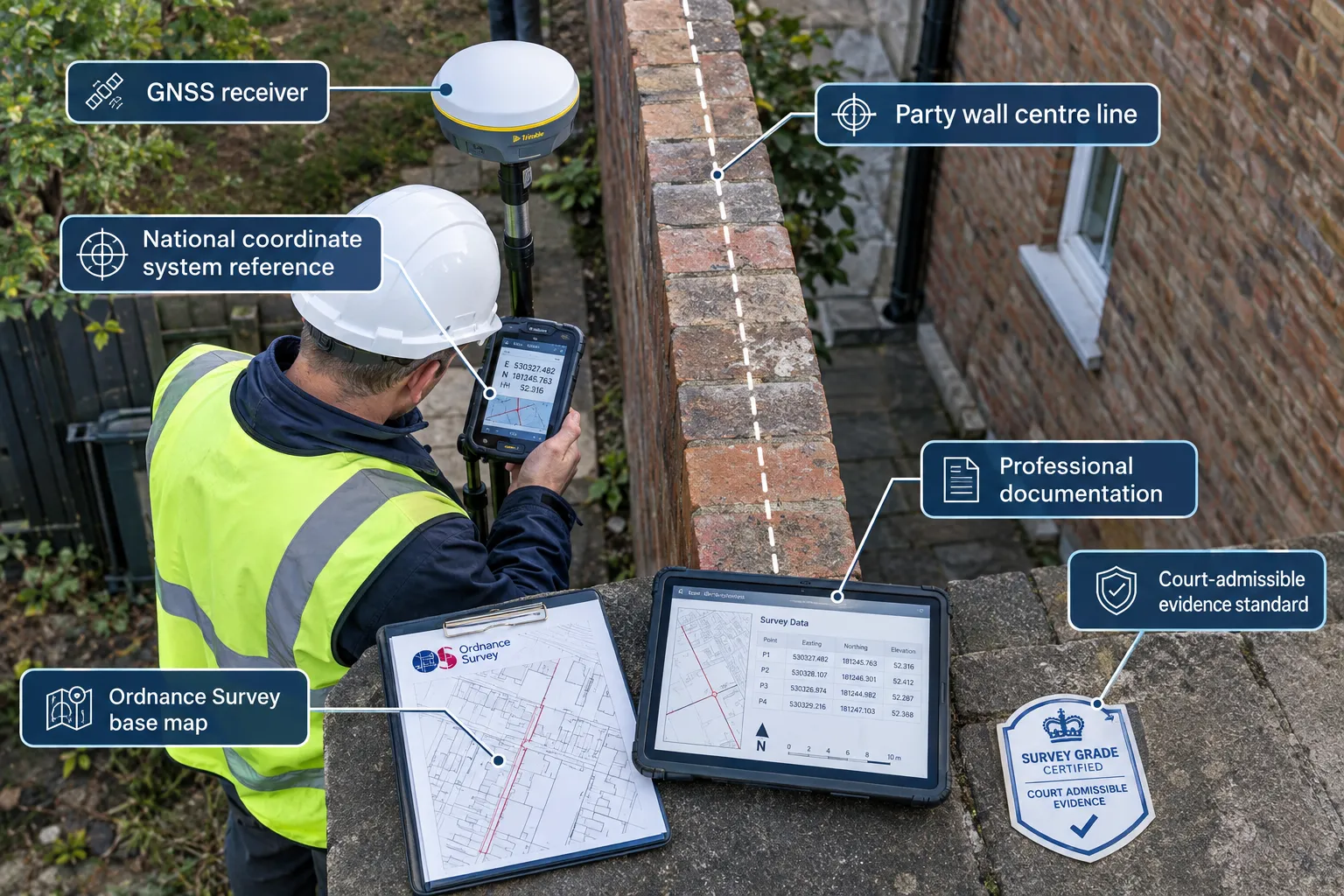
Party wall disputes present a specific challenge that boundary surveys alone do not always resolve. Under the Party Wall etc. Act 1996, the position of the party wall, its centre line, its thickness, and its relationship to the legal boundary, can determine whether a building owner has the right to carry out certain works, and whether those works have encroached on the adjoining owner's land.
When Coordinate Surveys Matter in Party Wall Cases
The most common scenarios where GPS-derived coordinates add decisive value in party wall matters include:
- Disputed wall ownership: Where the deed plan is ambiguous about whether a wall sits wholly on one owner's land or straddles the boundary, a coordinate survey can establish the wall's actual position relative to the legal line.
- Encroachment during construction: Where a neighbour's new structure, a basement, an extension, or a new wall, may have crossed the boundary, GPS measurements tied to a national datum provide objective before-and-after evidence.
- Party wall thickness and centre line: In dense urban areas, walls are sometimes built slightly off-centre. Coordinate measurements of both faces of the wall, combined with the legal boundary position, determine whether each owner's notional half lies within their title.
- Excavation near the boundary: Under Section 6 of the Party Wall etc. Act 1996, excavation within 3 or 6 metres of an adjoining owner's structure triggers specific notice requirements. GPS measurements confirm whether the proposed excavation falls within those distances. For more detail on this, see the guidance on party wall excavation notices.
A 2024 exposition on the current law of party wall surveyors' duties concludes that surveyors must act impartially, retain control of decision-making, and rely on sound technical measurements [10]. This reinforces the need for reliable coordinate surveys to support awards when boundary alignment or wall thickness is disputed [10].
The Party Wall Award and Coordinate Evidence
When a party wall surveyor produces an award, the formal document that sets out the rights and obligations of both parties, it must be technically sound enough to withstand legal challenge. If the award relies on a scaled plan that places the boundary within a 1-metre uncertainty band, and the disputed encroachment is only 200 mm, the award will not resolve the dispute.
GPS-derived coordinates, properly documented and referenced to the national grid, eliminate that uncertainty. The award can state, with measurable confidence, that the party wall centre line sits at a specific easting and northing, and that the proposed works remain within the building owner's title.
If you are dealing with a situation where a neighbour has begun work without the correct notices or agreements in place, understanding your rights is critical, see the guidance on what to do if a neighbour is carrying out party wall work on your boundary wall.
For a broader overview of how boundary disputes and party wall matters intersect, the guide to boundary dispute and party wall surveyors in London provides a comprehensive starting point.
International Evidence of GPS in Boundary Resolution
The use of GPS in boundary disputes is not confined to England and Wales. In July 2025, a joint Assam, Meghalaya interstate survey in India used advanced GNSS to verify coordinates of existing boundary pillars and establish new pillars along disputed sections, demonstrating GPS's role in resolving even intergovernmental boundary conflicts [1]. A 2025 case study on Thailand, Cambodia territorial disputes found that joint reference mapping using WGS84 GNSS coordinates reduced positional discrepancies by up to 95%, dramatically reducing ambiguity at contested borders [4].
A legal-geomatics analysis covering 2024-2026 highlights how GPS underpins accurate recording of real estate rights in systematic land registration projects, providing courts with robust technical evidence when ownership or limits are contested [7].
Practical Steps for Property Owners and Surveyors
Understanding the technology is useful, but knowing how to act on it is what matters. The following steps apply whether you are a property owner facing a boundary dispute or a surveyor preparing evidence for a party wall award.
For property owners:
- Instruct a chartered surveyor with specific experience in boundary and party wall work before any legal action begins. Early measurement is far cheaper than retrospective reconstruction.
- Preserve all physical evidence, do not remove fence posts, wall remnants, or boundary markers before they have been surveyed and photographed.
- Obtain copies of all title deeds, historical OS maps, and any previous survey plans. These form the documentary context that GPS coordinates must be interpreted against.
- If a neighbour has started work without serving the correct notices, seek advice promptly, see the guidance on neighbours building without a party wall agreement.
For surveyors:
- Reference all measurements to the national datum (ETRS89/OSGB36 in Great Britain) using at least two independent control marks.
- Carry out redundant observations and perform a formal least-squares adjustment. Document the residuals and the estimated positional uncertainty at each boundary point.
- Produce a formal survey plan showing grid coordinates, bearings, distances, and the accuracy class achieved.
- Retain all raw data, processing files, and field notes. In litigation, the opposing expert will request them.
- State clearly in any report what the GPS evidence shows and what it does not show, coordinates establish position, not legal title.
"GPS coordinates establish where a boundary physically sits. They do not, by themselves, determine who owns the land on either side. That question still requires legal analysis of title deeds, conveyancing history, and the law of adverse possession."
For property owners and professionals in specific areas, local expertise matters. Chartered surveyors covering North West London, South East London, and Essex are well-placed to carry out GPS-referenced boundary surveys that meet the evidentiary standards described in this article.
For those who need to understand the full scope of the Party Wall etc. Act 1996 before instructing a surveyor, the complete guide to the Party Wall Act and property rights sets out the legal framework in accessible terms.
Conclusion
GPS in boundary disputes and party wall evidence has transformed what is possible when older plans and physical features no longer agree. Sub-centimetre GNSS measurements, tied to national coordinate systems and supported by rigorous documentation, give courts and surveyors a level of positional certainty that scaled deed plans simply cannot provide.
The technology is not a magic solution. Coordinates must be interpreted alongside title deeds, physical monuments, and legal analysis. But when the dispute turns on a few centimetres, and many do, a properly conducted GPS survey is often the most persuasive piece of technical evidence available.
Actionable next steps for 2026:
- If a boundary or party wall dispute is emerging, instruct a chartered surveyor immediately to establish a baseline coordinate record before any works disturb the evidence.
- Confirm that any surveyor you instruct has experience with RTK or DGPS methods and can produce a formal survey plan referenced to the national grid.
- Review whether the Party Wall etc. Act 1996 applies to any proposed works, early compliance avoids the need for retrospective GPS evidence gathering.
- Where litigation is anticipated, discuss with your solicitor whether a joint GPS survey, agreed by both parties, could resolve the positional question without a full trial.
The combination of modern satellite positioning and rigorous professional practice means that boundary uncertainty, while never entirely eliminable, can now be reduced to a level that courts can work with confidently.
References
[1] Survey Starts Assam Meghalaya Work To Resolve Border Dispute – nenow.in
[2] Punjab And Haryana High Court Validates Use Of Dgps In Property Demarcation Relies On Chatgpt For Insights – 24law.in
[3] Boundary Matters – isurv.com
[4] The Role Of Geospatial Technology In Thailand Cambodia Border Territorial Disputes A Case Study Of The Northeastern Region – blog.bru.ac.th
[6] How Technology Drones Gps Is Changing Evidence In Boundary Disputes – thebarristersinc.com
[7] cjss.ug.edu.ge – cjss.ug.edu.ge
[8] Boundary Dispute And Relocation Survey Procedures Philippines – lawyer-philippines.com
[9] Gps Coordinates – rg-guidelines.nswlrs.com.au
[10] How To Play Nicely The Current Law Of Party Wall S – hstalks.com