A single centimetre of error in a boundary survey can shift the legal line between two properties by enough to place a fence, a wall, or even a building extension on the wrong side. That is not a hypothetical risk. In dense urban areas across the UK, disputes over a few centimetres of land regularly end up before the courts or before appointed surveyors under the Party Wall etc. Act 1996. Understanding how surveyors use ground control points and GPS in boundary disputes and party wall evidence is therefore not just a technical matter, it is a question of legal defensibility.
This article explains, in plain terms, the technology and methodology that modern chartered surveyors deploy to produce coordinate-based boundary evidence that stands up to professional and legal scrutiny.
Key Takeaways
- Ground control points (GCPs) tie survey measurements to a recognised national coordinate system, making boundary evidence reproducible and legally defensible.
- GPS and GNSS technology, including RTK and PPK methods, now allows surveyors to achieve centimetre-level accuracy in the field.
- Drone surveys combined with well-distributed GCP networks are increasingly used to produce high-resolution orthomosaics for boundary and party wall expert witness reports.
- UK surveyors are expected to comply with RICS guidance and Land Registry mapping conventions when presenting coordinate-based evidence in disputes.
- Courts and professional bodies are progressively favouring boundary evidence expressed as coordinates in recognised national datums over reliance on physical features alone.
What Are Ground Control Points and Why Do They Matter in Surveying?
A ground control point (GCP) is a precisely measured physical location on the ground whose coordinates are known in a recognised reference system. In the UK, that system is typically the Ordnance Survey National Grid (OSGB36) or the ETRS89 geodetic datum. GCPs act as anchors. Every measurement taken during a survey, whether by drone, total station, or GNSS rover, can be checked and corrected against these fixed reference locations.
Without GCPs, survey data floats in space. It may be internally consistent, meaning distances and angles between measured points are accurate relative to each other, but it cannot be reliably placed on a national map or compared with a Land Registry title plan. In a boundary dispute, that limitation is critical. A plan that cannot be tied to a recognised datum is far harder to defend in court or before a party wall surveyor.
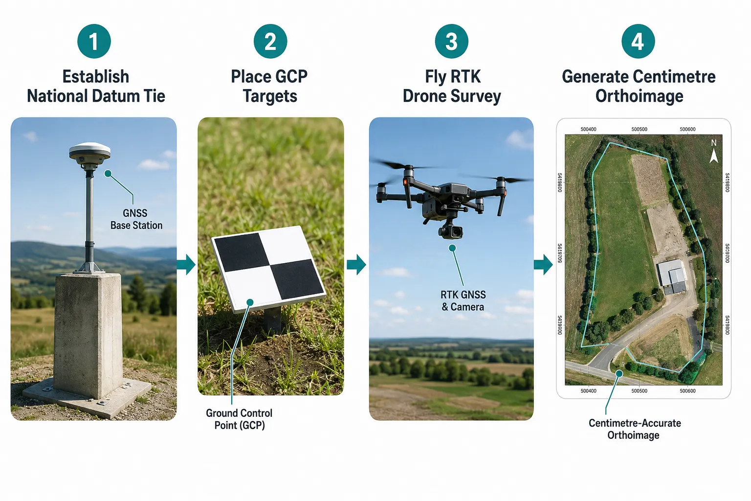
The physical form of a GCP varies by context. In large cadastral survey programmes, GCPs are often reinforced concrete pillars, for example, 15 cm x 15 cm x 75 cm monuments, installed at tri-junctions of boundaries and densified on kilometre-scale grids [2]. In urban UK boundary work, GCPs may be painted targets, nail-and-washer marks set into hard standing, or commercially produced survey targets placed on the ground before a drone flight. What matters is that their coordinates are established to a standard that meets the purpose of the survey.
The Hierarchy of Control Networks
Professional surveying practice recognises a hierarchy of control:
| Level | Description | Typical Accuracy |
|---|---|---|
| Primary | National geodetic monuments, GPS continuously operating reference stations | Sub-centimetre |
| Secondary | Local control points tied to primary network | 1-5 cm |
| Tertiary | Site-level GCPs established from secondary control | 1-10 cm |
| Auxiliary / Check Points | Independent verification points, not used in adjustment | Variable |
This hierarchy ensures that measurements made at different times, by different surveyors, using different equipment, can all be reconciled. For boundary disputes resolution, that reconcilability is the foundation of reliable expert evidence.
How Surveyors Use Ground Control Points and GPS in Boundary Disputes and Party Wall Evidence: The Technical Workflow
Understanding the step-by-step process helps property owners, solicitors, and adjoining owners appreciate what a thorough survey involves and why it takes the time it does.
Step 1, Establishing the Control Framework
The first task is to connect the survey to the national reference system. In the UK, surveyors typically use one of three approaches:
- GNSS static observation: The receiver is set up over a known or new control point and left to collect satellite data for an extended period. One highway surveying specification requires a minimum of two GNSS occupations using different satellite constellations, each of at least two hours [4]. For high-stakes boundary work, longer occupations improve accuracy.
- Real-Time Kinematic (RTK) GNSS: The rover receives real-time corrections from a base station or a network such as the Ordnance Survey's OS Net, achieving centimetre-level accuracy in minutes.
- Total station traverses: A total station measures angles and distances from known control points to new ones, extending the control network into areas where GNSS signals are obstructed by buildings or trees.
In the United States, cadastral project control must be tied to the National Spatial Reference System via tools such as NGS OPUS or real-time GNSS networks, with at least two control points required for larger projects [15]. The principle is identical in UK practice: boundary coordinates used in disputes must be consistent with a national datum and independently re-measurable.
The Society of Chartered Surveyors Ireland's boundary procedures state that deriving legal boundary point coordinates in the national reference frame using GNSS and total stations is the preferred approach, precisely because the evidence does not rely on physical features that may be destroyed, and aligns directly with the mapping used in litigation [3].
Step 2, Placing and Signalising GCPs
For drone-based surveys, GCPs must be physically placed on the ground before the flight. Best practice, supported by a 2025 ISPRS study on UAV cadastral surveys, indicates that approximately ten well-signalised GCPs plus at least one central GCP are needed to achieve reliable parcel-level accuracy [5]. A 2025 lidar and photogrammetry specification from a US transportation department requires ground control targets at least every 500 ft with interspersed validation points [7].
GCP targets should be:
- Large enough to be clearly visible in drone imagery (typically 40-60 cm square for low-altitude flights)
- High contrast, usually black and white checkerboard or cross patterns
- Evenly distributed across the survey area, including corners and edges
- Measured with RTK GNSS or total station before and after the flight
Planning GCPs at the flight-planning stage, not as an afterthought, is a requirement in several national technical guidelines [6][8]. This discipline ensures that the resulting orthomosaic is geometrically reliable across its full extent.
Step 3, The Survey Itself
With control established and GCPs in place, the surveyor conducts the primary data collection. In 2026, this increasingly means one or more of:
- RTK/PPK drone photogrammetry: The drone captures overlapping images. Post-processing kinematic (PPK) GPS logs from the drone are combined with GCP coordinates to produce an orthomosaic accurate to 1-3 cm. UK guidance for boundary expert witness work advises using drones with RTK/PPK GPS capable of centimetre-level positioning, supported by at least five well-distributed GCPs whose coordinates are established with GNSS or total stations [1].
- Terrestrial total station survey: Used where drone access is limited or where specific boundary features, a wall face, a fence post, a building corner, need to be measured directly.
- GNSS rover survey: Rapid collection of point coordinates across open areas.
For party wall matters, the surveyor will typically also measure the precise position of the party wall or party fence wall relative to the boundary line, recording any encroachments, deviations, or existing damage.
Step 4, Processing and Quality Control
Raw data is processed in specialist software. For photogrammetry, this involves structure-from-motion algorithms that reconstruct a 3D point cloud and then generate an orthomosaic, a geometrically corrected aerial image in which every pixel has a known ground coordinate. Check points (GCPs withheld from the processing adjustment) are used to verify the absolute accuracy of the output.
Victorian cadastral survey regulations in Australia legally require licensed surveyors to connect boundary surveys to at least three nearby permanent or primary cadastral marks; in subdivisions with more than ten lots, additional marks must be placed so that the distance between marks is no greater than 100 m [9]. While this is Australian regulation, the underlying principle, dense, well-distributed control for reproducible evidence, is directly applicable to UK urban boundary work.
Step 5, Producing the Expert Witness Report
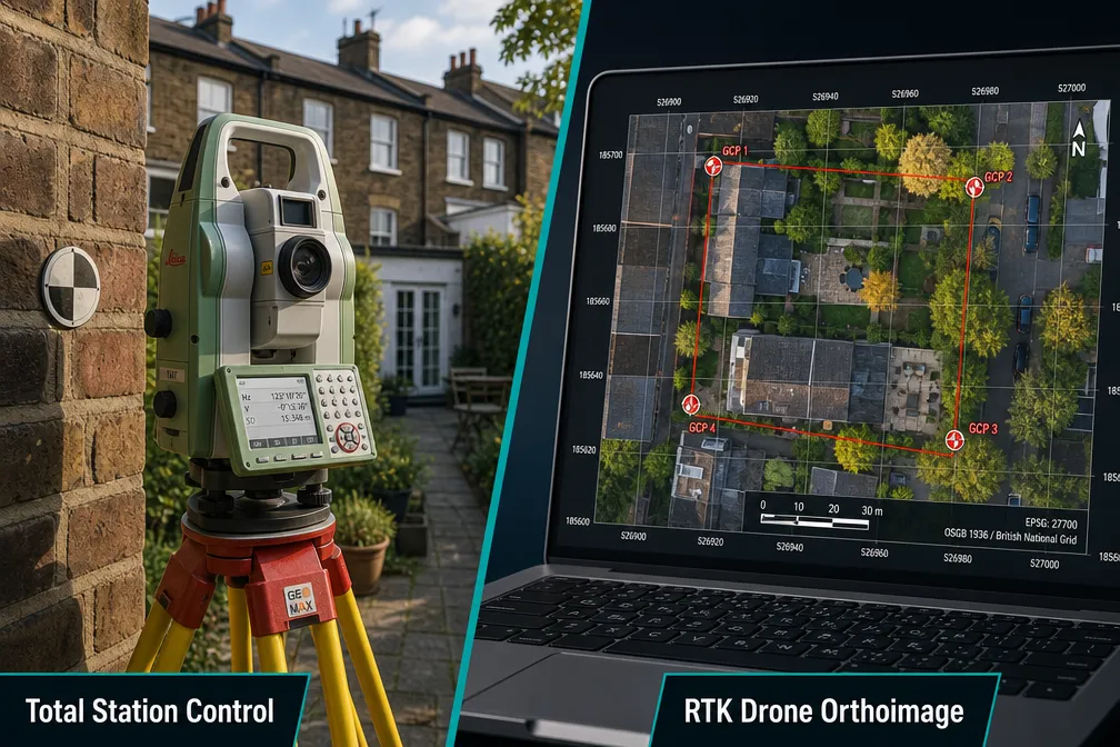
The final deliverable for a boundary or party wall dispute is a report that presents the survey findings clearly, with all measurements expressed in a recognised coordinate system and all methodology documented. Integrating RTK/PPK drone surveys with conventional GNSS and total-station control allows production of centimetre-accurate orthomosaics and 3D models showing the true position of boundary features and party walls relative to title plans [1].
For a boundary dispute expert witness report, the documentation typically includes:
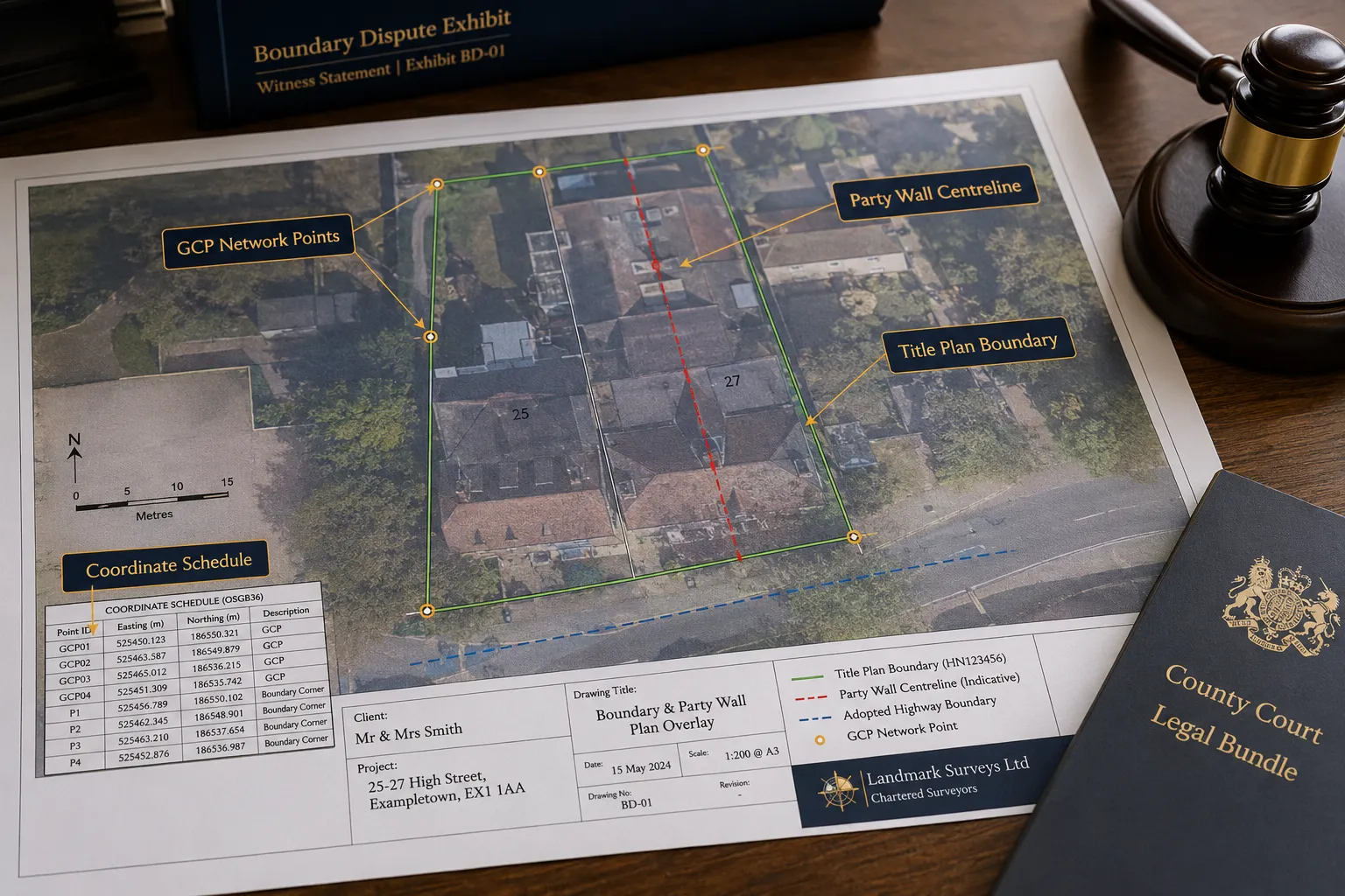
- A coordinate schedule listing all measured boundary points in the national grid system
- An annotated orthomosaic overlaid with the Land Registry title plan
- GCP observation logs and quality control statistics
- A written methodology statement confirming compliance with RICS guidance
How GPS and GCPs Strengthen Party Wall Evidence Specifically
Party wall disputes under the Party Wall etc. Act 1996 often hinge on precise questions: exactly where does the party wall sit relative to the boundary? Has construction encroached onto the adjoining owner's land? Has the wall been moved or rebuilt in a different position? These are questions that physical inspection alone cannot always answer, particularly when the original boundary features have been altered.
GPS and GCP-based surveying addresses these questions directly. By measuring the position of the party wall and expressing it as coordinates in the national grid, the surveyor creates evidence that:
- Does not depend on the continued existence of physical features, if a fence is later removed, the coordinate record remains [3]
- Can be independently verified by any other competent surveyor using the same national reference system
- Aligns directly with Land Registry title plans, which are georeferenced to the national grid
- Supports before-and-after comparison if a second survey is conducted after works are completed
For those navigating a party wall dispute, this level of precision is particularly valuable when the dispute involves questions about whether works have caused movement or encroachment. A pre-works survey establishing the precise position of the wall, followed by a post-works survey, gives the appointed surveyor objective evidence rather than competing assertions.
Practical Application: Drone Orthomosaics as Party Wall Exhibits
A drone orthomosaic tied to GCPs can show, at centimetre resolution, the position of a party wall relative to the legal boundary line. When overlaid with the Land Registry title plan at the correct scale, it becomes a powerful exhibit. Courts and appointed surveyors can see, rather than simply read about, the spatial relationship between structures and boundaries.
This approach is now a key expectation for surveyors giving evidence in boundary disputes, with compliance with RICS guidance and Land Registry mapping conventions increasingly required [1]. The party wall expert witness who presents coordinate-based evidence supported by documented GCP networks and observation logs is in a significantly stronger position than one relying solely on scaled drawings or physical descriptions.
Standards, Regulations, and Professional Expectations in 2026
The regulatory and professional landscape around GPS and GCP use in boundary surveying has tightened considerably in recent years. Several trends are converging in 2026.
RICS and Land Registry Expectations
RICS guidance increasingly expects boundary surveyors to use coordinate-based methods for expert witness work. The Land Registry's own mapping is georeferenced, and expert evidence that cannot be reconciled with that mapping is at a disadvantage. Surveyors acting as party wall surveyors in London and across the UK are expected to be familiar with these requirements.
National Reference Systems
A recurring theme across multiple national jurisdictions is the requirement to tie all boundary measurements to the official national spatial reference system. Saudi Arabia's technical guidelines require all measurements to be tied to the Saudi National Spatial Reference System [6][8]. The Society of Chartered Surveyors Ireland emphasises alignment with the Irish Transverse Mercator [3]. US cadastral guidance mandates connection to the National Spatial Reference System [15]. In the UK, this means OSGB36 or ETRS89, accessed via OS Net or equivalent.
This consistency matters because boundary disputes can span years or decades. Evidence expressed in a national coordinate system can be re-examined, re-measured, and compared with future surveys long after the original fieldwork is done.
Documentation Requirements
Updated resurvey procedures published in 2026 direct surveyors to maintain coordinate lists for all control points in both geodetic and projected systems in GIS form [12][13]. This documentation requirement supports clear, auditable exhibits in court. A surveyor who cannot produce their GCP observation logs, quality control statistics, and coordinate schedules when cross-examined is in a weak position.
Key documentation that should accompany any boundary or party wall survey used as evidence includes:
- GCP coordinate schedule with accuracy estimates
- GNSS observation logs showing occupation times and satellite geometry
- Processing report from photogrammetry or adjustment software
- Check point residuals confirming absolute accuracy
- Methodology statement referencing applicable RICS or other professional guidance
The Growing Role of Drones
Drone surveys with RTK/PPK GPS are now mainstream in boundary and party wall surveying. Their value lies in the combination of speed, coverage, and the ability to produce a georeferenced orthomosaic that serves as both a measurement tool and a visual exhibit. The 2026 guidance for boundary expert witness work specifically advises using drones with RTK/PPK GPS capable of centimetre-level positioning, supported by at least five well-distributed GCPs [1].
For properties in areas served by chartered surveyors in London and across the wider South East, drone surveys are particularly useful in dense urban environments where traditional ground-based methods are time-consuming and where the overhead perspective reveals boundary features that are obscured at ground level.
Common Mistakes That Undermine Boundary and Party Wall Survey Evidence
Even experienced surveyors can produce evidence that is challenged or discounted if certain fundamentals are overlooked. The most common weaknesses include:
- Insufficient GCPs: Using fewer than the recommended number, or placing them all on one side of the survey area, introduces systematic errors that distort the orthomosaic [5][7].
- No tie to national datum: Survey data that is internally consistent but not tied to the national grid cannot be compared with Land Registry title plans [3][15].
- Poor GNSS observation quality: Short occupation times, poor satellite geometry, or failure to use a second independent occupation increase coordinate uncertainty [4].
- No check points: Without independent check points withheld from the adjustment, there is no way to verify the absolute accuracy of the survey output [7].
- Inadequate documentation: Failure to retain and disclose observation logs, processing reports, and coordinate schedules undermines credibility under cross-examination.
- Relying solely on physical features: Fences, walls, and hedges move, are replaced, or are removed. Coordinate evidence persists [3].
For anyone involved in a boundary or party wall matter, whether as a building owner, an adjoining owner, or a legal representative, understanding these potential weaknesses helps in assessing the quality of survey evidence presented by either side. Resources such as Do I Need a Party Wall Agreement? and guidance on how close you can build to a neighbour's boundary provide useful context for understanding when professional survey evidence becomes essential.
Conclusion
The question of how surveyors use ground control points and GPS in boundary disputes and party wall evidence is ultimately a question about the quality and durability of the evidence produced. Centimetre-accurate, coordinate-based survey evidence tied to the national reference system, supported by documented GCP networks and rigorous observation procedures, is the standard that courts, appointed surveyors, and professional bodies increasingly expect in 2026.
Actionable next steps for property owners and legal professionals:
- Instruct a RICS-regulated chartered surveyor with demonstrable experience in GPS and GCP-based boundary surveying before any dispute reaches a formal stage.
- Request a methodology statement from any surveyor you instruct, confirming how GCPs were established, what national reference system was used, and how accuracy was verified.
- Commission a pre-works survey before any construction near a boundary or party wall, creating a coordinate-based baseline that protects all parties.
- Retain all survey documentation, including GCP logs and processing reports, as these will be required if the evidence is challenged.
- Seek specialist advice early, whether through a party wall surveyor in North London or a boundary dispute expert witness, before positions become entrenched.
The technology exists to resolve most boundary and party wall disputes with objective, reproducible evidence. The key is ensuring that evidence is collected, documented, and presented to the standard the situation demands.
References
[1] Integrating Drone Surveys In Boundary Expert Witness Reports Rics Compliance For 2026 Land Registry Challenges – princesurveyors.co.uk
[2] Technicalmanual 1 – revenue.odisha.gov.in
[3] Scsi Boundaries Gn Final – scsi.ie
[4] Chapter 05 – highways.dot.gov
[5] Isprs Archives Xlviii M 6 2025 169 2025 – isprs-archives.copernicus.org
[6] Land Survey Technical Guideline – geoportal.sa
[7] Ctdot Lidar And Photogrammetry Specifications July 2025 – portal.ct.gov
[8] Aerial Surveying Technical Guideline – geoportal.sa
[9] Surveying (Cadastral Surveys) Regulations 2025 – classic.austlii.edu.au
[10] DGPS Survey GCP Terms of Reference – cmdachennai.gov.in