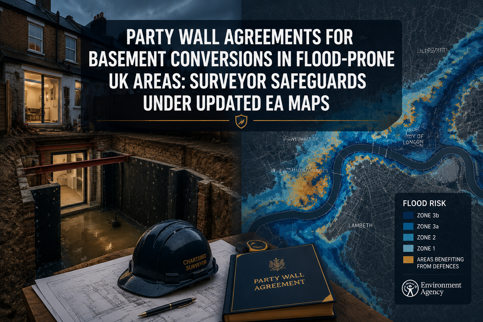
Nearly one in six properties in England sits within a flood-risk area, yet basement conversions continue to surge across London and other dense urban centres where land values make below-ground space financially compelling. The collision between that demand and the Environment Agency's significantly expanded flood mapping — updated twice between August 2025 and May 2026 — has placed party wall surveyors at the centre of a new and complex set of obligations. Understanding how Party Wall Agreements for Basement Conversions in Flood-Prone UK Areas: Surveyor Safeguards Under Updated EA Maps interact with planning policy, structural risk, and neighbour protection is now essential for any building owner, developer, or professional adviser working on below-ground works.
Key Takeaways
- The EA's August 2025 and May 2026 flood map updates introduced climate-change-adjusted flood zones and detailed surface water depth banding that directly affect basement conversion planning and party wall risk assessments.
- Basement conversions almost always trigger the Party Wall etc. Act 1996, requiring formal notices and, in most cases, a full Party Wall Award before works begin.
- Surveyors in flood-prone areas must now embed waterproofing specifications, percolation test data, and contingency clauses directly into Party Wall Awards.
- Failure to cross-reference updated EA flood maps during the party wall process exposes building owners to neighbour claims for water ingress damage and potential planning enforcement action.
- Specialist chartered surveyors with flood-risk expertise are increasingly essential for projects in Flood Zones 2, 3, and the newly mapped surface water risk areas.
How Updated EA Flood Maps Are Reshaping Basement Conversion Risk
The Environment Agency's Flood Map for Planning has undergone two landmark updates that every surveyor working on basement projects must now treat as mandatory reference documents.
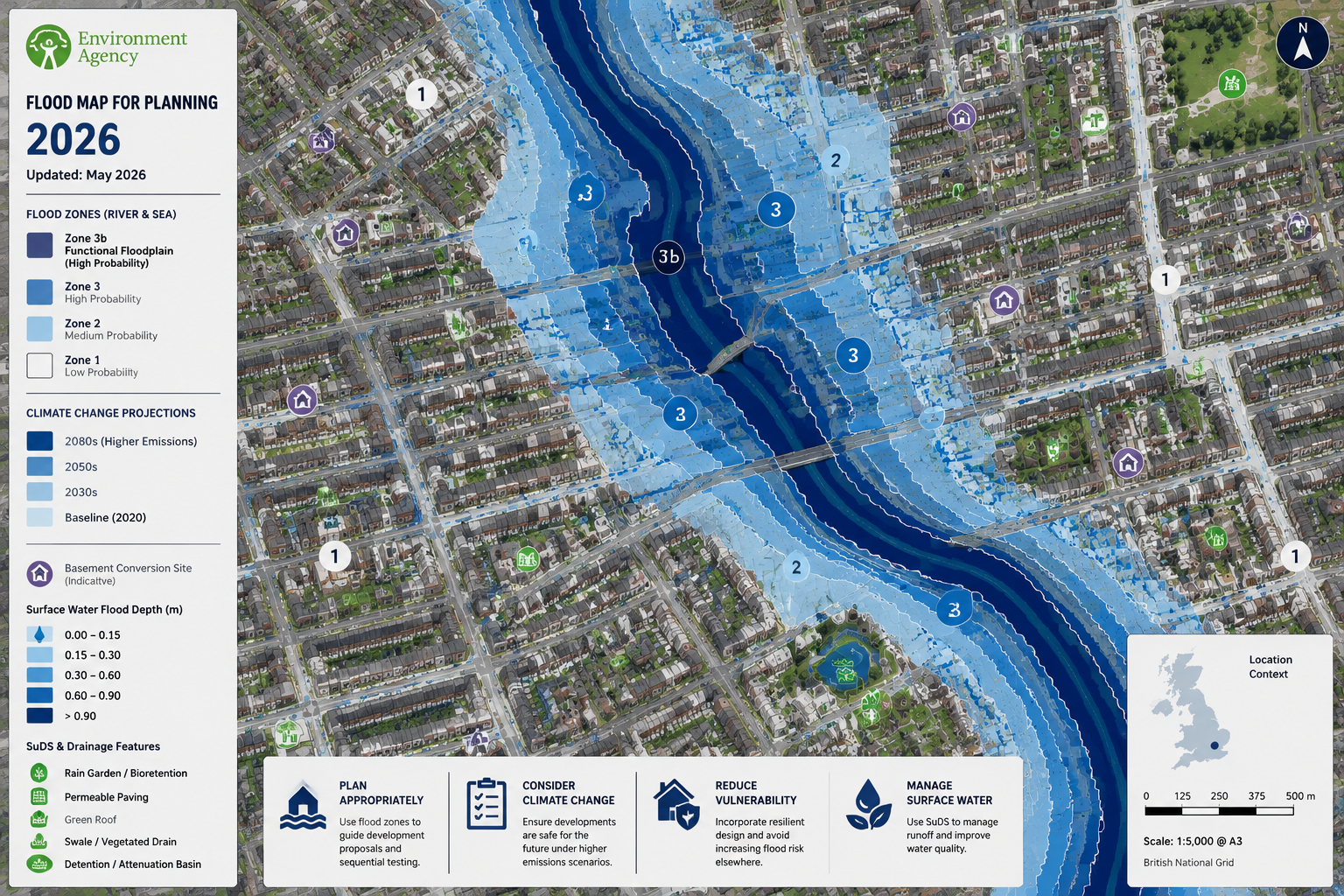
On 27 August 2025, the EA introduced a dedicated "Flood Zones plus climate change" map layer [2]. This layer projects how Flood Zones 2 and 3 could expand over the next century, replacing a fragmented set of earlier datasets with a single, clearer resource. For the first time, local planning authorities and their consultees — including party wall surveyors — could see in one place how a site currently classified as Flood Zone 1 (lowest risk) might migrate into Zone 2 or 3 within the lifespan of a structural alteration.
Then, on 28 May 2026, the EA updated its Flood Map for Planning again, this time adding surface water flood risk extents that incorporate climate change projections through to the 2070s [1]. Critically, this update includes banded depth information for surface water flooding. A basement conversion site might show, for example, a projected inundation depth of 0.3 m in a 1-in-30-year event rising to over 0.9 m in a 1-in-1,000-year event with 2070s climate factors applied. That granularity changes the engineering and legal calculus entirely.
What the New Flood Zones Mean for Below-Ground Works
Under current planning policy, developments in Flood Zones 1, 2, 3, and 3b require flood risk assessments of varying depth and rigour [5]. The updated maps mean that some sites previously considered low-risk now fall within expanded zone boundaries or carry surface water depth classifications that trigger formal assessment requirements. Platforms aggregating EA data now offer access to over 18 flood risk and water data layers, allowing surveyors to interrogate a site's historic flood record alongside its projected future risk [6].
The EA also maintains a Historic Flood Map layer recording areas previously affected by river, coastal, and groundwater flooding [7]. For basement conversions, groundwater records are particularly significant: a site with a history of groundwater emergence is a fundamentally different engineering proposition from one affected only by surface water runoff.
As of April 2026, the EA had formally identified a set of locations classified as Flood Risk Areas under criteria derived from the EU Floods Directive [8]. Properties within these designated areas face the most stringent planning and design requirements, and any party wall process touching such a site must reflect that elevated risk profile.
Party Wall Agreements for Basement Conversions in Flood-Prone UK Areas: Surveyor Safeguards Under Updated EA Maps — The Legal Framework
When the Party Wall etc. Act 1996 Applies
Basement conversions almost invariably engage the Party Wall etc. Act 1996 on at least one of two grounds.
First, where works involve excavation within 3 metres of a neighbouring structure and to a depth lower than the neighbour's foundations, a Notice under Section 6 of the Act is required. This is the most common trigger for basement projects in terraced and semi-detached housing. For a detailed explanation of how this rule operates, see the guide on the Party Wall Act 3-metre rule.
Second, where the basement involves underpinning, cutting into, or otherwise working on a party wall or party fence wall, a Notice under Section 3 is required. Many basement conversions require both notices simultaneously.
Once a neighbour serves a counter-notice or dissents, the parties must appoint surveyors and proceed to a Party Wall Award — a legally binding document setting out how works are to be carried out. For an overview of what a Party Wall Award covers in practice, the Party Wall Award guide for London and Surrey provides useful context.
The Excavation Notice in Flood-Prone Contexts
The Party Wall excavation notice serves a dual purpose in flood-risk areas. It formally notifies the adjoining owner of the proposed works, but it also creates the procedural gateway through which a surveyor can introduce flood-specific safeguards into the Award. A notice served without reference to the site's flood zone classification and updated EA mapping data is likely to be challenged and may require amendment before an Award can be agreed.
In 2026, urban boroughs such as Camden, Islington, and Westminster have seen high volumes of basement conversion projects proceed through the full Party Wall Award process, with informal consent becoming increasingly rare given the technical complexity involved [4]. The same pattern is emerging in flood-prone outer London boroughs and commuter towns where the updated EA maps have reclassified significant residential areas.
Adjoining Owner Rights and Damage Claims
Adjoining owners in flood-risk areas face a compounded risk: basement excavation can alter groundwater flow paths, increase hydrostatic pressure on shared walls, and — if waterproofing fails — create conditions for water ingress into neighbouring properties. The Party Wall Act provisions on damage to property are the primary legal mechanism through which neighbours can seek redress, but prevention through a well-drafted Award is far preferable to post-event litigation.
Surveyor Safeguards: What Must Be Built Into the Party Wall Award
The shift in EA flood mapping has made it insufficient for a party wall surveyor simply to record the method of excavation and specify a schedule of condition. In flood-prone areas, the Award must address a broader set of technical and contingency matters.
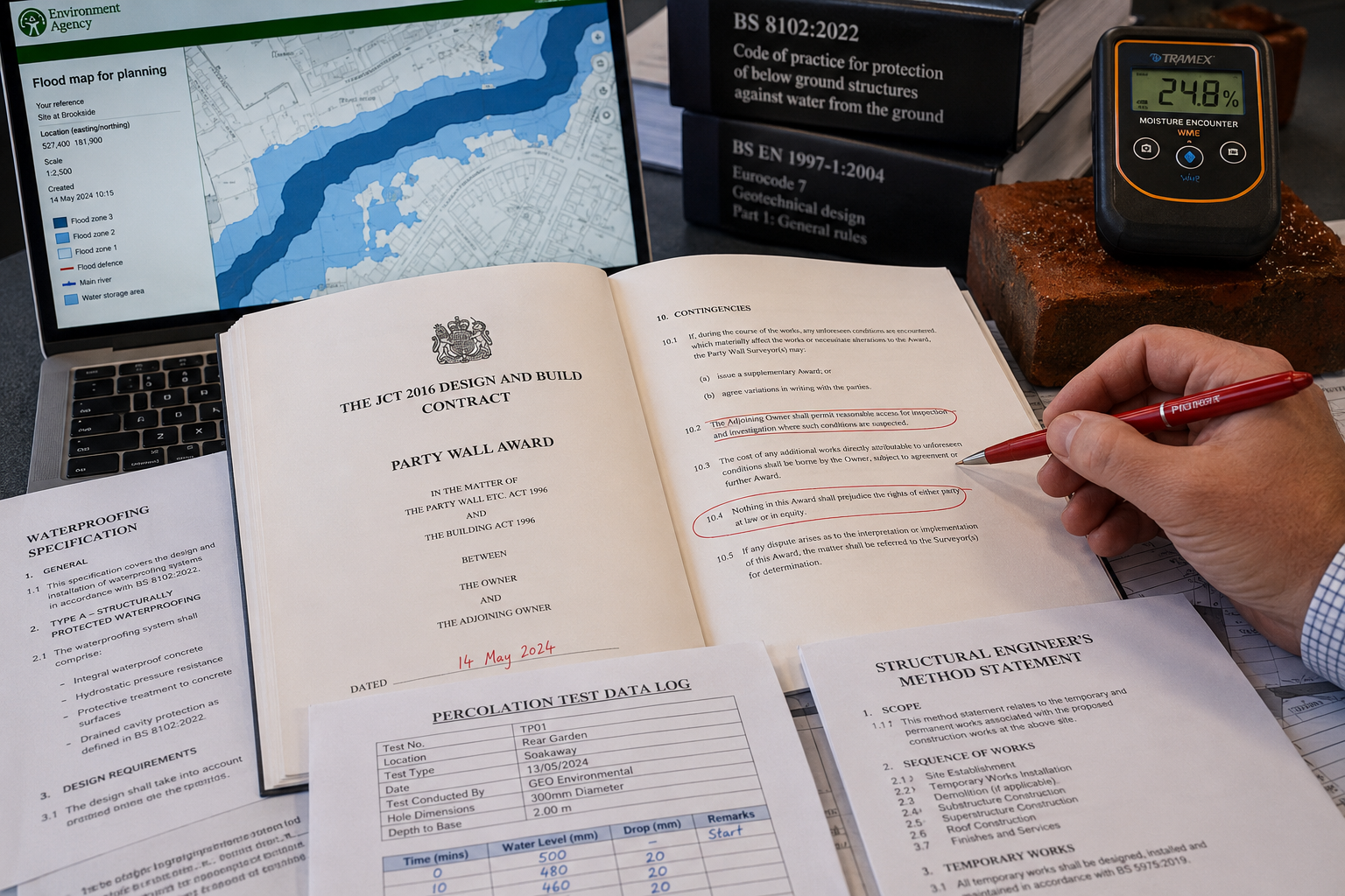
Waterproofing Specifications in the Award
A Party Wall Award for a basement conversion in a flood-risk area should specify the waterproofing system to be used, referenced against the BS 8102:2022 standard for protection of below-ground structures against water ingress. The Award should state:
- The structural waterproofing grade required (Grade 1 to Grade 3 depending on intended use)
- Whether a Type A (barrier), Type B (structurally integral), or Type C (drained cavity) system — or combination — is specified
- The installer qualification requirements
- Inspection hold points during construction
This level of detail protects both the building owner and the adjoining owner by ensuring that the waterproofing design is not left to a contractor's discretion after the Award is agreed.
Percolation Tests and Groundwater Monitoring
Where the updated EA flood maps indicate surface water or groundwater risk, the Award should require percolation testing and, where appropriate, a groundwater monitoring programme before excavation commences. Percolation test data establishes the rate at which water moves through the soil and informs the design of any drainage or tanking system. Without this data, a waterproofing specification is essentially theoretical.
The Award can require:
| Requirement | Timing |
|---|---|
| Percolation test by qualified engineer | Pre-commencement |
| Groundwater level baseline readings | Minimum 4 weeks pre-commencement |
| Ongoing groundwater monitoring during excavation | Weekly during active dig |
| Post-completion groundwater check | 3 months after practical completion |
Contingency Clauses for Unexpected Water Ingress
One of the most important — and most frequently omitted — elements of a Party Wall Award in flood-prone areas is a contingency protocol for unexpected water ingress during excavation. The Award should specify:
- The threshold at which works must stop (e.g., sustained inflow exceeding a defined rate)
- The notification procedure for the adjoining owner's surveyor
- The remediation steps that must be agreed before works resume
- The insurance arrangements that must remain in place throughout
This is not merely good practice; it is a direct response to the risk profile now visible on the updated EA maps. A site showing projected surface water flood depths of 0.6 m or more in a 1-in-100-year event with climate change applied is a site where unexpected groundwater conditions during excavation are a realistic, not theoretical, possibility [1].
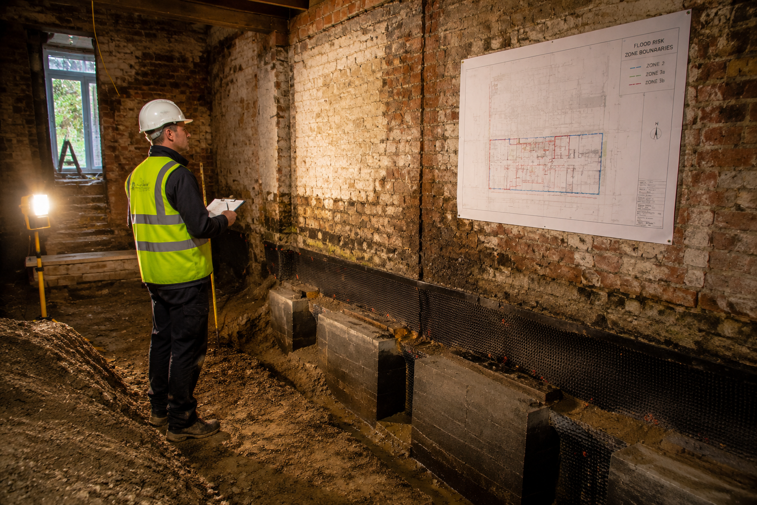
Schedule of Condition Reports
Before any basement excavation begins, a thorough schedule of condition report of the adjoining property must be prepared. In flood-risk areas, this report should extend beyond the standard photographic record of cracks and finishes to include:
- Existing damp or moisture readings in basement and ground floor areas
- Any evidence of historic water ingress or efflorescence
- The condition of existing damp-proof courses and membranes
This baseline is critical if a damage claim arises later, because distinguishing pre-existing damp from works-related water ingress is genuinely difficult without a detailed pre-works record.
Practical Guidance for Building Owners and Developers in 2026
Step-by-Step Process for Flood-Risk Basement Projects
- Check the updated EA Flood Map for Planning before any design work begins. Identify which flood zone applies and whether the site falls within a designated Flood Risk Area [8].
- Commission a flood risk assessment if required by the applicable flood zone classification [5]. This assessment should reference the May 2026 surface water depth banding data [1].
- Appoint a structural engineer with basement and waterproofing experience to produce a design that responds to the flood risk data.
- Serve Party Wall Notices — both Section 3 and Section 6 as applicable — at least two months before the planned start date for excavation works.
- Engage a party wall surveyor experienced in flood-risk basement projects. The surveyor must cross-reference the EA maps and the structural engineer's flood risk assessment when drafting the Award.
- Agree the Party Wall Award with all required flood-specific provisions: waterproofing specification, percolation test requirements, groundwater monitoring schedule, contingency clauses, and insurance arrangements.
- Carry out pre-commencement percolation tests and condition survey of the adjoining property.
- Implement the monitoring programme throughout construction and provide post-completion data to the adjoining owner's surveyor.
Choosing the Right Surveyor
Not all party wall surveyors have the specialist knowledge needed for flood-risk basement projects. Building owners should seek a chartered surveyor in London with demonstrable experience in basement conversions and familiarity with EA flood mapping tools. In areas such as South West London, East London, and Islington — all of which contain significant areas of updated flood risk classification — this expertise is not optional.
Adjoining owners who receive a Party Wall Notice and are unsure of their rights should consult a surveyor promptly. The guide on what to do if a neighbour is carrying out party wall work sets out the options clearly, including the right to appoint a surveyor at the building owner's expense.
Insurance Considerations
A Party Wall Award in a flood-risk area should confirm that the building owner's contractor holds adequate public liability insurance and that the building owner has notified their own insurer of the works. Some insurers impose conditions on basement conversion works in flood zones; failing to notify them can invalidate cover at precisely the moment it is most needed.
Conclusion
The combination of updated Environment Agency flood mapping and the technical demands of basement conversion works has fundamentally raised the bar for party wall practice in the UK. The August 2025 climate-change flood zone layer and the May 2026 surface water depth banding update are not administrative footnotes — they are material changes to the risk environment that surveyors, building owners, and developers must actively incorporate into every stage of the party wall process.
Actionable next steps for anyone planning a basement conversion in a flood-prone area in 2026:
- Run the site address through the EA's updated Flood Map for Planning immediately, before committing to any design or budget.
- Instruct a chartered surveyor with specific basement and flood-risk experience to advise on Party Wall Notice requirements and Award content.
- Ensure the Party Wall Award contains explicit provisions on waterproofing grade, percolation testing, groundwater monitoring, and contingency protocols — not just a standard method statement.
- Commission a detailed schedule of condition of all adjoining properties before works commence.
- Review insurance arrangements with both the contractor and the building owner's own insurer before the first spade goes into the ground.
The legal framework of the Party Wall etc. Act 1996 remains unchanged, but the risk landscape it must now govern has expanded significantly. Surveyors who adapt their practice to reflect the updated EA maps will protect their clients, their neighbours, and their own professional standing. Those who do not will find themselves exposed when the first unexpected water ingress occurs on a site that the new flood data had already flagged as high-risk.
References
[1] EA Flood Map For Planning May 2026 Update – https://www.unda.co.uk/news/ea-flood-map-for-planning-may-2026-update/?utm_source=openai
[2] August 2025 Update To Environment Agency Flood Map For Planning Fmfp – https://aegaea.com/about-us/news/august-2025-update-to-environment-agency-flood-map-for-planning-fmfp/?utm_source=openai
[3] Party Wall Specialists – Basement Conversions and the Party Wall Act – https://partywallspecialists.com/?p=24124&utm_source=openai
[4] Party Wall Act Compliance For Basement Conversions 2026 Surveyor Protocols In High Demand Urban Areas – https://princesurveyors.co.uk/blog/party-wall-act-compliance-for-basement-conversions-2026-surveyor-protocols-in-high-demand-urban-areas/?utm_source=openai
[5] Flood Risk Assessment Flood Zones 1 2 3 And 3b – https://www.gov.uk/guidance/flood-risk-assessment-flood-zones-1-2-3-and-3b?utm_source=openai
[6] Flood Risk Maps – https://maplify.co.uk/FloodRiskMaps?utm_source=openai
[7] Historic Flood Map Layer – https://mymaps2.oxfordshire.gov.uk/server/rest/services/Third_Party/Environment/MapServer/24?utm_source=openai
[8] Flood Risk Areas – https://www.data.gov.uk/dataset/42c31542-228d-439b-8dbe-e72135dae71c/flood-risk-areas?utm_source=openai