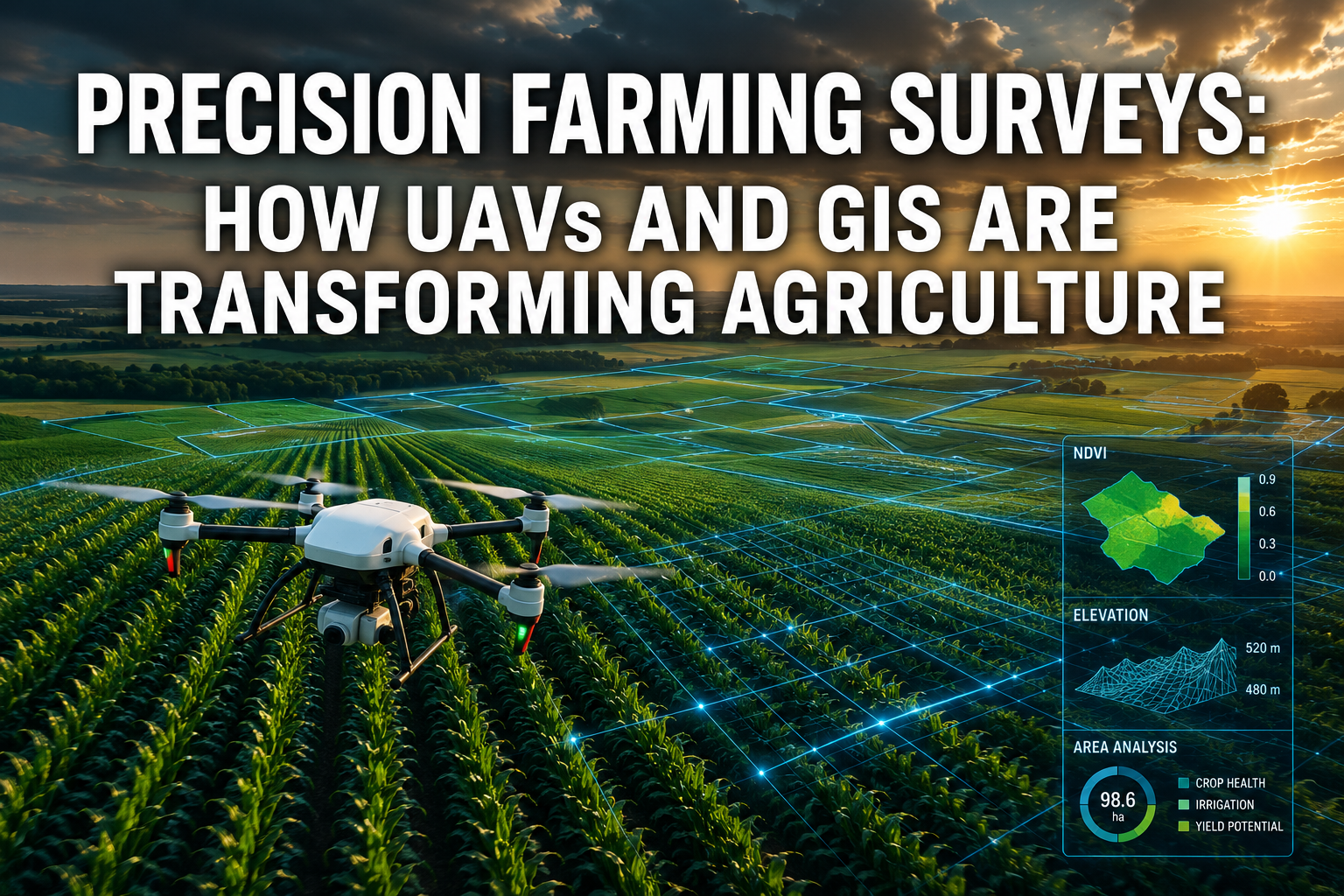
A single wheat farm in Kansas loses an estimated $25,000 per season to undetected soil variability — money that better field mapping could save. Across the globe, farmers are discovering that precision farming surveys using unmanned aerial vehicles (UAVs) and Geographic Information Systems (GIS) are not a luxury reserved for large agribusinesses. They are fast becoming the most practical tool available for anyone who wants to protect yields, cut input costs, and manage land with confidence.
Precision Farming Surveys: How UAVs and GIS Are Transforming Agriculture represents one of the most significant shifts in land management since the introduction of GPS-guided tractors. This article explains how the technology works, what it delivers in the field, and what farmers and land managers need to know to get started.
Key Takeaways
- UAVs equipped with multispectral sensors can detect crop stress, weed pressure, and soil variability weeks before problems become visible to the naked eye.
- GIS platforms translate raw drone data into actionable field maps that guide targeted, site-specific interventions.
- Combining UAV imagery with satellite data has improved biomass and nitrogen estimation accuracy by up to 31%.
- Autonomous UAV systems and AI-powered analysis are reducing the time and expertise needed to run precision surveys.
- Standardization of UAV hardware and data formats remains a key challenge slowing wider adoption.
What Are Precision Farming Surveys and Why Do They Matter
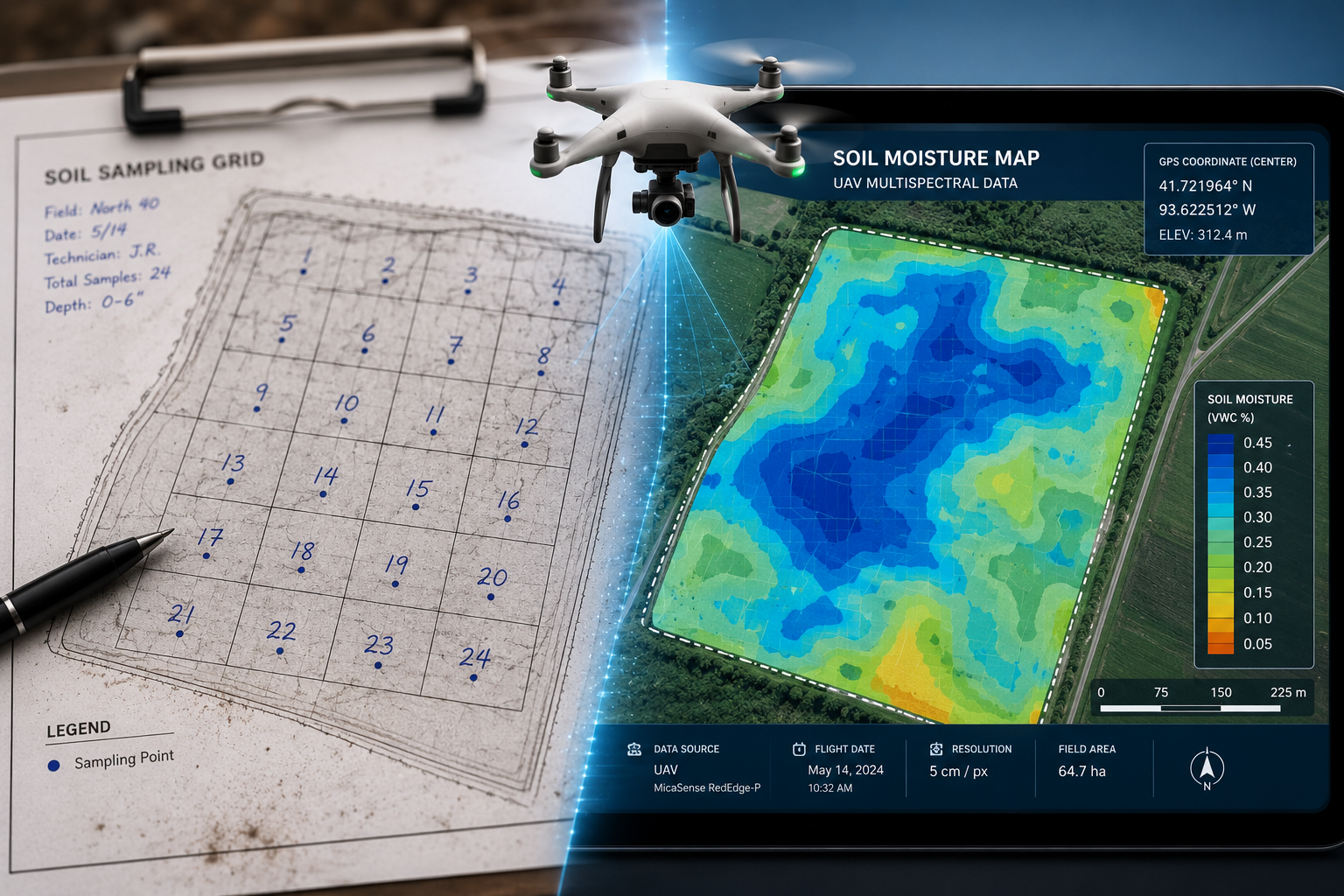
Precision farming surveys are systematic data-collection exercises carried out across agricultural land to build a detailed, spatially accurate picture of field conditions. Unlike traditional scouting — where a farmer walks transects and records observations by hand — UAV-based surveys capture thousands of data points per hectare in a single flight.
The data collected typically includes:
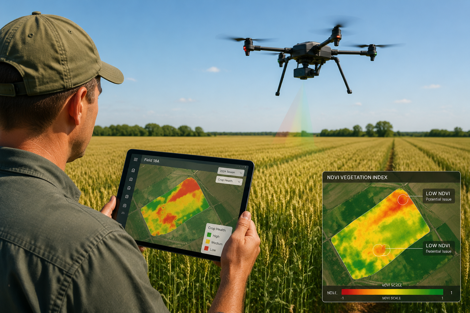
- Vegetation indices (such as NDVI and NDRE) that reveal plant health
- Thermal imagery identifying water stress and irrigation inefficiencies
- RGB imagery for visual crop assessment and weed mapping
- Elevation models showing drainage patterns and compaction zones
When this data is loaded into a GIS platform, it becomes a living map. Farmers can overlay historical records, soil test results, and yield data to identify patterns that would never emerge from manual inspection alone.
The economic case is straightforward. Site-specific management — applying fertilizer, water, or pesticide only where needed — reduces input waste and protects margins. For context, a professional drone roof survey in the built environment follows the same core logic: use aerial data to find problems early, before they become expensive repairs. The principle translates directly to agricultural land.
How UAVs and GIS Work Together in the Field
The UAV Data Capture Process
Modern agricultural UAVs are purpose-built for survey work. They carry interchangeable sensor payloads and fly pre-programmed grid patterns at consistent altitudes, ensuring uniform image overlap for photogrammetric processing [1]. Automated mission planning software handles route optimization, obstacle avoidance, and adaptive re-visits to areas flagged during the initial pass — a capability that has improved dramatically in recent years [1].
A typical survey workflow looks like this:
| Stage | Activity | Output |
|---|---|---|
| Pre-flight planning | Define field boundary, set flight altitude, select sensor | Mission file |
| Data capture | Autonomous grid flight with multispectral/thermal sensors | Raw imagery |
| Processing | Photogrammetry software stitches images | Orthomosaic, DSM |
| GIS analysis | Indices calculated, zones identified | Prescription maps |
| Field action | Variable-rate application or targeted scouting | Reduced inputs |
GIS: Turning Raw Data Into Decisions
GIS software is the analytical engine that makes UAV data useful. Raw imagery from a drone flight is meaningless without spatial referencing and index calculation. Once processed, GIS platforms allow farmers to:
- Create variable-rate prescription maps for fertilizer and pesticide application
- Track field changes over time by comparing surveys from different dates
- Integrate satellite imagery to fill gaps between UAV flights
- Export data directly to precision application equipment
The integration of UAV imagery with satellite data deserves special attention. Research has shown that combining high-resolution drone data with satellite coverage through super-resolution methods improved biomass estimation accuracy by 18% and nitrogen estimation accuracy by 31% compared to using either platform alone [5]. This fusion approach is particularly valuable for large farms where flying every hectare by drone every week is not practical.
"The real power of GIS is not the map itself — it is the ability to ask spatial questions that a spreadsheet cannot answer."
Precision Farming Surveys: How UAVs and GIS Are Transforming Agriculture in Practice
Crop Health Monitoring and Early Stress Detection
UAVs equipped with multispectral sensors are now standard tools for crop health monitoring. They detect subtle differences in light reflectance that indicate stress from nutrient deficiency, disease, or water shortage — often two to three weeks before symptoms are visible at ground level [4]. Early detection at this stage means intervention is still cheap and effective.
A grain farmer in the East Midlands, for example, used multispectral surveys to identify a magnesium deficiency affecting roughly 12% of a 200-hectare field. By applying a targeted foliar treatment only to the affected zones, the farm reduced product use by 60% compared to a blanket application, while achieving the same yield outcome. The survey paid for itself within a single season.
Weed Mapping and Site-Specific Management
Weed pressure is one of the most costly and variable problems in arable farming. UAV-based weed mapping has advanced significantly, with optimized detection algorithms now capable of identifying individual weed species within a crop canopy at centimetre-level resolution [7]. The resulting maps feed directly into variable-rate sprayer systems, eliminating the need to treat entire fields when infestation is patchy.
This approach mirrors the logic behind a specific defect report in building surveys — rather than a blanket assessment, the goal is to pinpoint exactly where the problem exists and address it with precision. The same discipline applied to weed management reduces herbicide use, lowers costs, and supports compliance with increasingly strict agrochemical regulations.
Soil Management and Drainage Mapping
High-resolution elevation models generated from UAV surveys reveal micro-topography that drives water movement across a field. Wet hollows, compaction ridges, and drainage channel blockages all show up clearly in digital surface models. Farmers use this data to plan drainage improvements, adjust cultivation depth, and identify areas where soil health investment will deliver the greatest return.
The connection to professional surveying practice is direct. Just as a boundary survey establishes the precise limits of a property, an elevation survey from a UAV establishes the precise physical character of agricultural land — information that underpins every management decision that follows.
Orchard and Specialist Crop Management
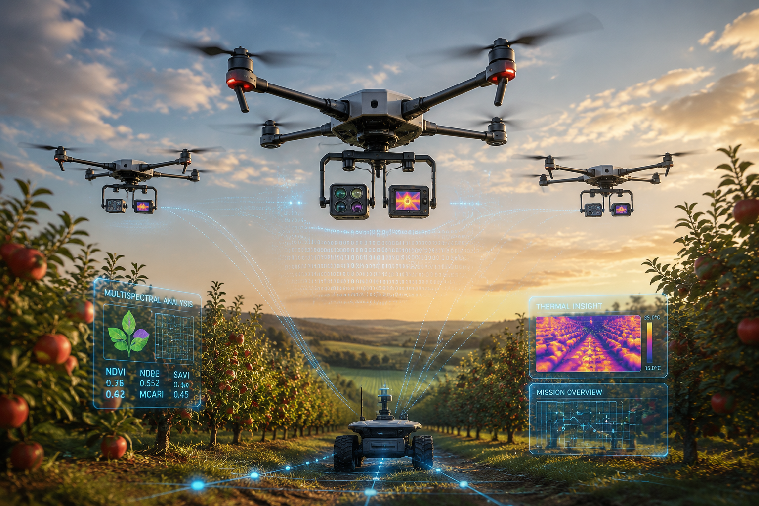
UAV technology is not limited to arable crops. In orchards and vineyards, drones are used to monitor canopy density, identify disease hotspots, and optimize irrigation scheduling [9]. The ability to fly between tree rows at low altitude and capture detailed imagery of individual plants makes UAVs uniquely suited to high-value perennial crops where per-plant management is economically justified.
Collaborative systems that pair UAVs with unmanned ground vehicles (UGVs) are extending this capability further. In these setups, the drone provides a field-wide overview while the ground vehicle carries out targeted interventions — applying treatments, collecting soil samples, or deploying sensors — without human operators needing to enter the field [6]. This approach is particularly valuable in orchards where access is restricted and labour costs are high.
The Role of AI in Advancing UAV Survey Capability
Artificial intelligence is accelerating the value of precision farming surveys at every stage of the workflow. AI-powered image analysis tools can now process multispectral and thermal data in near real-time, flagging anomalies and generating recommendations without requiring agronomic expertise from the operator [2].
Key AI applications in agricultural UAV surveys include:
- Automated crop counting for stand establishment assessment
- Disease classification from RGB and multispectral imagery
- Yield prediction modelling using in-season vegetation index data
- Irrigation scheduling driven by thermal stress mapping [2]
The practical implication is that the barrier to entry for precision farming surveys is falling. A farmer does not need to be a GIS specialist or a data scientist to extract value from drone survey data. Modern platforms handle the analysis and present results as simple, actionable maps.
This parallels the evolution of professional surveying tools in the built environment, where technology has made complex assessments more accessible. A chartered surveyor today uses digital tools that would have been unrecognisable twenty years ago, yet the underlying professional judgment remains central to the value delivered. The same is true in precision agriculture.
Challenges Facing Wider Adoption of Precision Farming Surveys
Despite clear benefits, several barriers slow the adoption of UAV and GIS-based precision farming surveys.
Standardization Gaps
The lack of standardized UAV hardware and data formats for agricultural applications remains a significant challenge [3]. Battery life, flight duration in adverse weather, and data processing pipelines vary widely between manufacturers. This makes it difficult for farmers to compare results across seasons or switch between service providers without losing data continuity.
Regulatory Complexity
UAV operations in many countries require operator certification, airspace authorization, and compliance with privacy regulations. These requirements add cost and administrative burden, particularly for smaller farming operations.
Data Management Skills
Generating high-quality UAV data is only half the challenge. Interpreting GIS outputs and translating them into field decisions requires skills that many farm businesses do not yet have in-house. Investment in training and advisory services is needed to close this gap.
Cost Considerations
Entry-level agricultural UAV systems with basic RGB cameras start at a few thousand pounds. Professional multispectral setups with GIS software subscriptions can cost significantly more. For smaller farms, contracting a specialist survey service is often more cost-effective than owning equipment outright.
Precision Farming Surveys: How UAVs and GIS Are Transforming Agriculture — The Road Ahead
The trajectory of precision farming surveys is clear. Autonomous UAV systems are becoming more reliable and more affordable. AI analysis tools are becoming faster and more accurate. GIS platforms are integrating with farm management software, accounting systems, and supply chain traceability tools to create end-to-end digital farm management.
Several developments are particularly worth watching in 2026:
- Swarm UAV systems that allow multiple drones to survey large areas simultaneously, cutting survey time dramatically
- Edge computing on-board drones that process imagery in flight and deliver results immediately on landing
- Integration with carbon accounting platforms as farmers seek to document soil carbon sequestration and qualify for environmental payment schemes
- Hyperspectral sensors moving from research settings into commercial agricultural use, enabling detection of specific nutrient deficiencies and pathogen infections with greater precision
For farmers considering their first precision survey, the most important step is to start with a clear question. What problem needs solving? Is it variable yield across a field? Unexplained crop loss in a particular zone? Inefficient irrigation? Defining the question determines the sensor type, survey frequency, and GIS analysis required.
Professional support is available. Just as a property owner might commission a homebuyer report or building survey to understand the condition of an asset before making decisions, farmers can commission professional UAV survey services to generate the data they need without investing in equipment ownership.
Conclusion
Precision farming surveys using UAVs and GIS have moved firmly from experimental technology to proven farm management practice. The evidence is consistent: early detection of crop stress, targeted input application, and data-driven soil management deliver measurable returns across a wide range of farm types and scales.
The core insight is simple. Better data leads to better decisions. A field that has been systematically surveyed with multispectral sensors and mapped in GIS is a field that can be managed with confidence rather than guesswork.
Actionable next steps for farmers and land managers:
- Identify one specific field management challenge — variable yield, drainage problems, weed pressure — and commission a targeted UAV survey to address it.
- Engage a GIS-capable agronomist or survey service to ensure data is processed into usable prescription maps, not just raw imagery.
- Build a baseline dataset by surveying the same fields at the same growth stages each season, creating a time-series record that reveals trends invisible in a single snapshot.
- Explore integration between UAV survey outputs and existing farm management software to streamline the path from data to field action.
- Stay informed about regulatory changes affecting UAV operations in your region, as airspace rules continue to evolve.
For those already familiar with professional survey services in the built environment, the parallels are instructive. Whether assessing a building or a field, the principle is the same: systematic, expert data collection followed by informed professional judgment produces outcomes that guesswork cannot match. For more expert guidance on survey technology and professional practice, explore the Kingston Surveyors blog for insights across a range of survey disciplines.
References
[1] mdpi – https://www.mdpi.com/2073-4395/16/5/564?utm_source=openai
[2] mdpi – https://www.mdpi.com/2504-446X/8/11/664?utm_source=openai
[3] S44378 025 00055 2 – https://link.springer.com/article/10.1007/s44378-025-00055-2?utm_source=openai
[4] mdpi – https://www.mdpi.com/2072-4292/10/9/1423?utm_source=openai
[5] arxiv – https://arxiv.org/abs/2505.21746?utm_source=openai
[6] arxiv – https://arxiv.org/abs/1911.03098?utm_source=openai
[7] arxiv – https://arxiv.org/abs/2503.07210?utm_source=openai
[8] Gis And Drone Mapping In Agriculture – https://jinghongdrone.com/gis-and-drone-mapping-in-agriculture?utm_source=openai
[9] S11119 021 09813 Y – https://link.springer.com/article/10.1007/s11119-021-09813-y?utm_source=openai