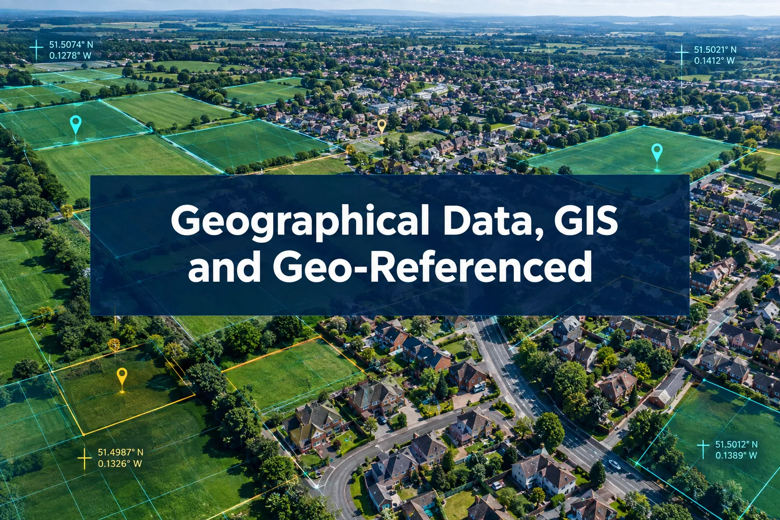
Boundary disputes in England and Wales cost property owners an average of £12,000 to £50,000 in legal and professional fees before resolution, yet a significant proportion of those disputes hinge on a single question: where, precisely, does the boundary lie? The answer increasingly depends on the quality, accuracy, and admissibility of geographical data, GIS and geo-referenced evidence in UK surveying disputes. For solicitors, chartered surveyors, and property owners navigating these cases, understanding how mapped evidence is assembled, challenged, and weighed is no longer optional, it is fundamental to case strategy.
Key Takeaways
- Geo-referenced survey evidence, including GNSS coordinates, GIS layers, and drone imagery, has become a standard component of modern UK boundary and property disputes.
- Ordnance Survey plans alone are rarely sufficient; courts expect a layered evidential package combining physical, documentary, and spatial data.
- Professional GNSS equipment can achieve sub-centimetre accuracy, but that precision is only meaningful when calibrated against reliable control points and historic context.
- GIS data is powerful but not decisive on its own; courts treat it as part of a broader evidential mix that includes title deeds, historic plans, and witness evidence.
- Instructing a specialist land surveyor early, rather than a general practitioner, significantly improves the quality and defensibility of geo-referenced evidence.
What Is Geo-Referenced Evidence and Why Does It Matter in UK Disputes
Geo-referenced evidence is any data that has been tied to a specific location on the Earth's surface using a recognised coordinate system, most commonly the British National Grid (BNG) or WGS84. In a surveying dispute context, this includes everything from a GNSS-measured boundary peg to a georectified historic aerial photograph overlaid on a current Ordnance Survey base map.
The significance of this type of evidence has grown sharply as digital tools have become more accessible. According to RICS consumer guidance, topographic surveys now serve as a primary method for establishing property boundaries, providing precise measurements of physical features relative to a fixed coordinate framework [8]. Where a title plan might show a boundary as a line of roughly 1mm width (representing approximately 500mm on the ground at 1:500 scale), a properly executed topographic survey can resolve that ambiguity to within millimetres.
Why precision matters in disputes:
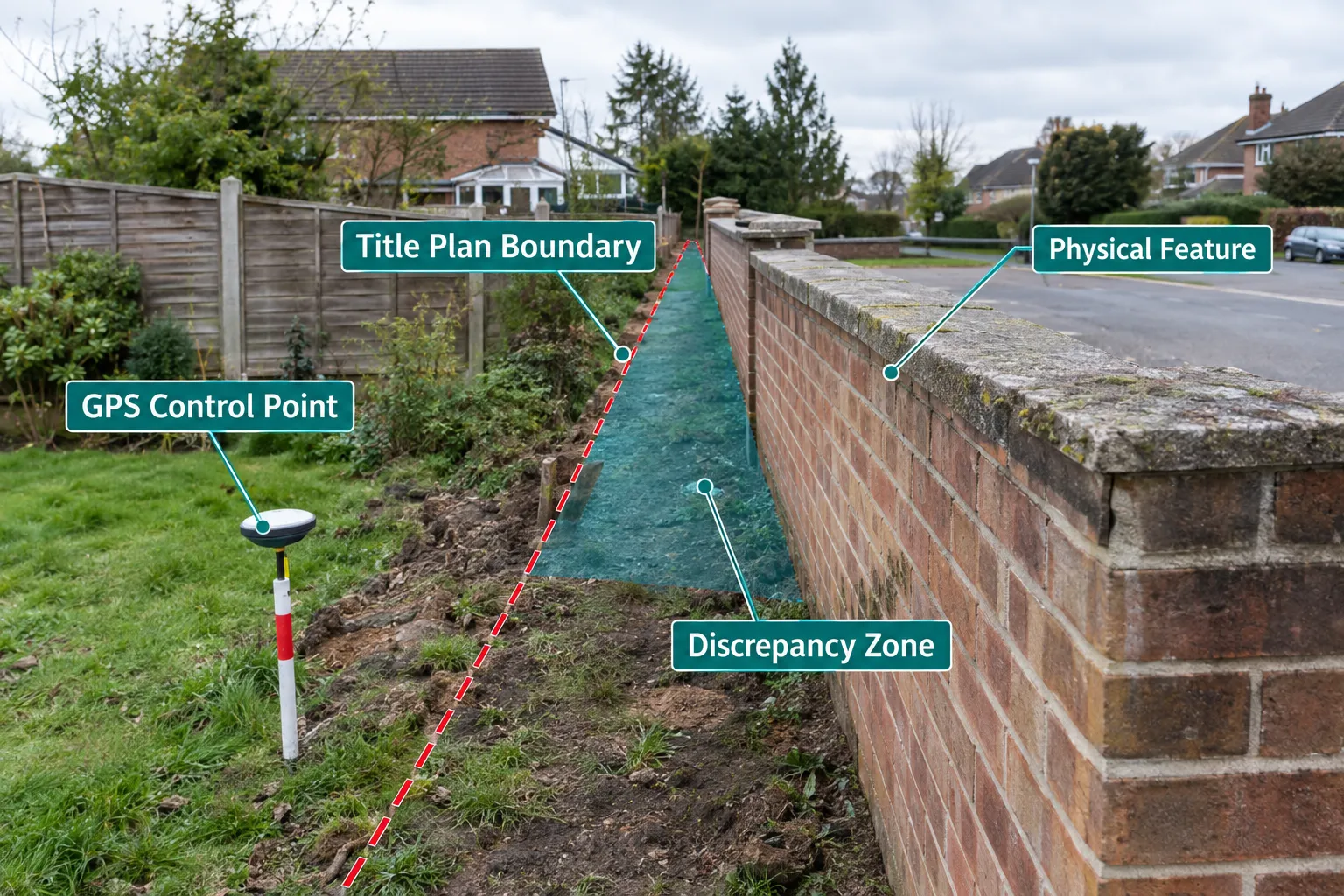
- A 200mm discrepancy between a fence line and a title boundary can represent the difference between a lawful encroachment and a trespass.
- In adverse possession claims, the exact extent of the land possessed must be established with sufficient certainty to satisfy the Land Registration Act 2002.
- Valuation disputes, particularly those involving ransom strips or development land, can turn on whether a boundary falls on one side or the other of a physical feature.
The courts have consistently held that the starting point for any boundary determination is the conveyance documents and their attached plans, not the physical features on the ground [5]. However, where those documents are ambiguous or silent, geo-referenced physical survey evidence becomes the primary tool for reconstruction.
How Surveyors Build a Geo-Referenced Evidential Package
The assembly of geographical data, GIS and geo-referenced evidence in UK surveying disputes follows a structured methodology that draws on multiple data sources, each with its own accuracy profile and evidentiary weight.
The Core Data Sources
1. GNSS and Total Station Surveys
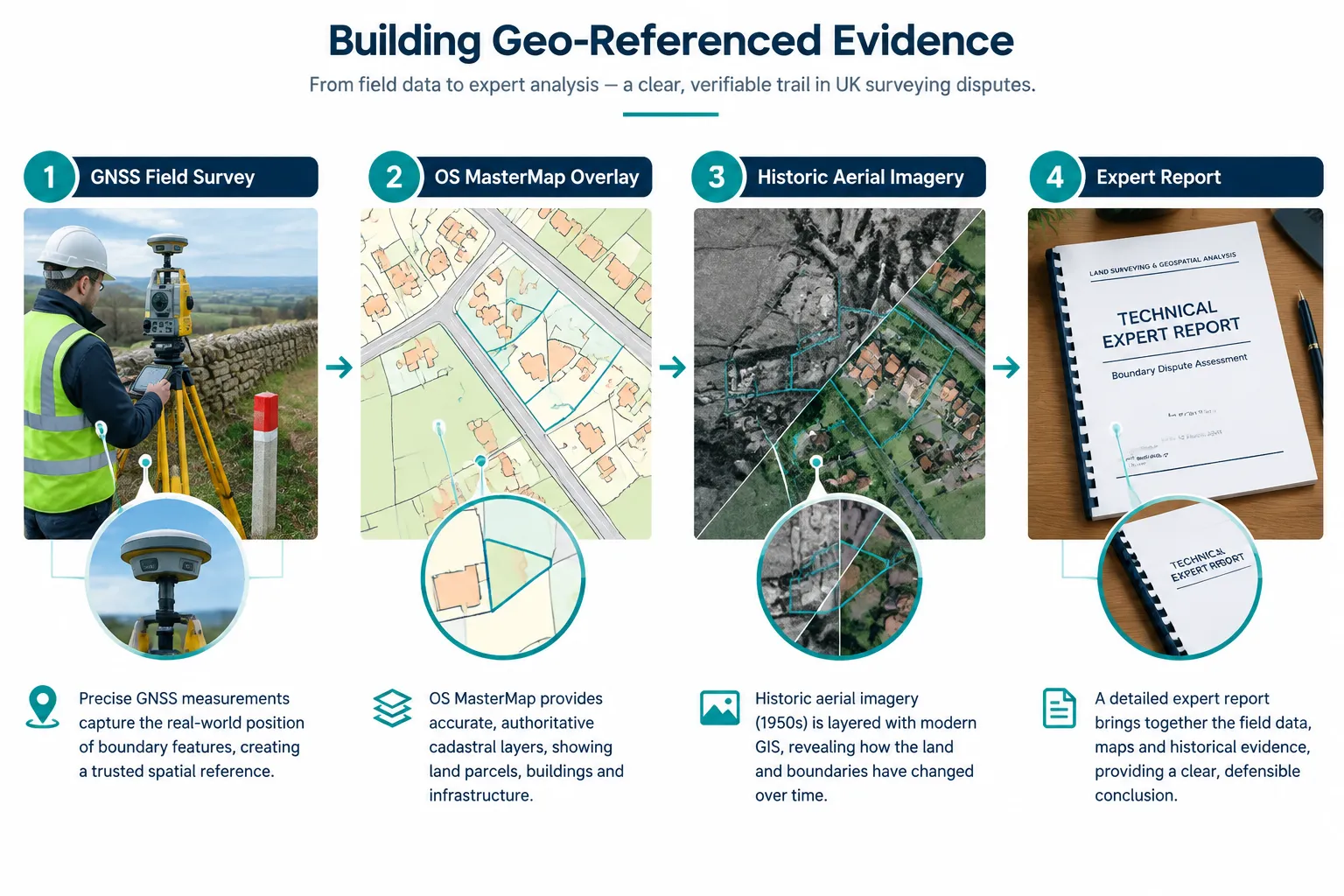
Modern boundary surveys use Global Navigation Satellite System (GNSS) receivers capable of Real-Time Kinematic (RTK) positioning, achieving horizontal accuracies of 10-20mm under good conditions. Total stations, electronic theodolites with integrated distance measurement, are used where satellite signal is obstructed by buildings or tree canopy. Together, these instruments allow surveyors to capture the precise coordinates of physical features: fence posts, wall faces, hedge centrelines, and existing boundary markers [2].
Professional GNSS benchmarks require at least two independent control points tied to the OS National GPS Network or Ordnance Survey's OS Net infrastructure. Without this calibration, even high-precision measurements float in space and cannot be reliably compared to historic plans.
2. Ordnance Survey MasterMap and Large-Scale Plans
OS MasterMap Topography Layer, supplied at 1:1250 scale in urban areas, is the standard cadastral reference in England and Wales. It is important to note, however, that OS mapping is not a legal record of title, it reflects the general position of physical features at the time of survey, not the legal boundary [8]. Courts and practitioners treat OS plans as a useful contextual layer within a broader GIS-based evidence package, not as a definitive source [5].
3. Historic Aerial Imagery and Photogrammetry
Georectified aerial photographs, sourced from the National Collection of Aerial Photography (NCAP), Getmapping, or local authority archives, allow surveyors to reconstruct the position of features at specific dates. This is particularly valuable in adverse possession claims, where the claimant must demonstrate continuous factual possession for the qualifying period [10]. When a 1970s aerial photograph is georectified and overlaid on a current GIS layer, it can reveal whether a fence line has moved, when a structure was erected, or whether a disputed strip was ever cultivated.
4. LiDAR and Drone Survey Data
Drone-mounted cameras and LiDAR sensors now generate dense point clouds and orthophotographs with ground sample distances of 20-50mm. These outputs can be imported directly into GIS software and overlaid with title plan data, producing a three-dimensional record of the site at a specific date. For complex cases involving sloped ground, retaining walls, or structures that straddle a boundary, this level of detail is often essential. Drone roof survey services in London illustrate how UAV technology is already embedded in mainstream survey practice.
5. Google Earth and Street View
Digital tools including Google Earth Pro and Street View have become routine in adverse possession and boundary claims, providing time-stamped imagery that can corroborate or contradict witness evidence [10]. While these sources lack the geometric precision of a professional survey, they are regularly cited in expert reports as supporting contextual evidence.
Layering the Evidence in GIS
The real power of modern geo-referenced evidence lies in layering. A specialist surveyor will import all available data, GNSS measurements, OS MasterMap, historic aerial imagery, LiDAR, and title plan scans, into a GIS platform such as ESRI ArcGIS or QGIS. Each layer is assigned its accuracy metadata, and discrepancies between layers are mapped and quantified.
The output is typically a series of scaled plans showing:
- The legal boundary as derived from the title deeds
- The physical boundary as measured on the ground
- The OS MasterMap boundary
- Historic boundary positions from aerial photography
- The zone of uncertainty, expressed as a measured corridor
This layered approach forms the evidential backbone of most modern construction disputes resolution cases involving boundary or encroachment issues.
The Legal Status of GIS Evidence in UK Courts and Tribunals
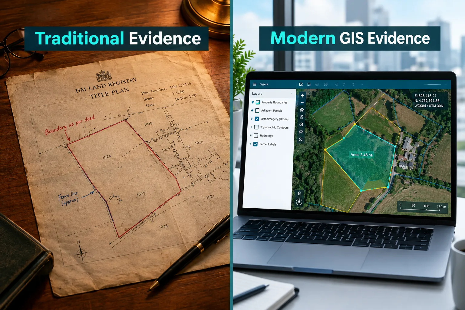
Understanding the legal weight of geographical data, GIS and geo-referenced evidence in UK surveying disputes requires a clear distinction between what GIS can prove and what it cannot.
What Courts Will and Will Not Accept
The authoritative position, confirmed in case law and professional guidance, is that GIS data is powerful but not decisive without historic context [3]. In Boas v Aventure International Ltd, the Court of Appeal reinforced the principle that appellate courts will be slow to overturn a first-instance judge's findings of fact in boundary disputes, precisely because those findings depend on a careful weighing of multiple evidence types, physical, documentary, and spatial [3]. No single GIS layer, however accurate, can substitute for that holistic assessment.
The Estates Gazette has noted that the evidence needed to establish a boundary includes: the conveyance and its plan, any statutory declarations, physical features on the ground, and expert survey evidence, with each source tested against the others [5]. GIS evidence fits into this framework as a tool for quantifying and visualising relationships between those sources, not as a standalone answer.
"The court is not bound by the precision of a GPS coordinate. It is bound by the legal boundary as properly construed from the conveyance documents, with all available evidence brought to bear."
This does not diminish the value of geo-referenced evidence. In practice, a well-constructed GIS-based expert report can be decisive in demonstrating that a physical feature is inconsistent with the title plan, or that a claimed boundary position is geometrically impossible given the measurements. The Charlton v Forrest case illustrates how detailed survey evidence, when properly presented, can resolve apparently intractable boundary disagreements by exposing measurement errors in earlier plans [9].
Pre-Action Protocols and Shared GIS Evidence
Structured pre-action protocols in boundary and property disputes are increasingly built around shared geo-referenced evidence. The RICS boundary dispute protocol recommends that both parties instruct their surveyors to agree a common coordinate datum and, where possible, to produce a joint measured survey before proceedings are issued [2]. This approach reduces costs, narrows the issues in dispute, and gives the court or tribunal a reliable spatial framework within which to assess the competing claims.
Where party wall disputes escalate into boundary litigation, the party wall award and its associated plans often form the first layer of geo-referenced evidence in the subsequent proceedings.
RICS mediation protocols, which have become more prominent in 2024-2026, are now structured around technical survey data as the primary shared reference point [1]. Mediators with a surveying background are better placed to facilitate resolution when both parties have access to a common GIS-based plan, rather than arguing from incompatible title plan interpretations.
Practical Guidance for Property Owners, Solicitors, and Surveyors
Instructing the Right Expert
RICS guidance is explicit: boundary disputes should be handled by specialist land surveyors, not general building surveyors or valuers [6]. The distinction matters because boundary work requires expertise in geodesy, cadastral mapping, and legal boundary interpretation that falls outside the scope of a standard Level 3 building survey or structural survey in London. Instructing the wrong type of expert is a common and costly mistake.
When selecting a boundary surveyor, the following qualifications and capabilities should be confirmed:
| Requirement | Why It Matters |
|---|---|
| RICS membership (MRICS/FRICS) | Ensures adherence to professional standards and PI insurance |
| Experience in boundary dispute work | Specialist knowledge of cadastral law and evidence rules |
| GNSS and total station capability | Necessary for sub-centimetre accuracy |
| GIS software proficiency | Required for layered evidential plans |
| Expert witness experience | Ability to present and defend evidence in court or tribunal |
Cost and Accessibility in 2026
A geo-referenced boundary survey for a typical residential dispute in 2026 ranges from approximately £1,500 to £4,500 depending on site complexity, the volume of historic data to be processed, and whether a full expert report is required for litigation. More complex commercial or development land disputes can attract fees of £8,000 to £25,000 or more. For context on broader survey costs, see how much a structural survey costs as a benchmark for professional survey expenditure.
These costs should be weighed against the potential value of the land in dispute and the likely litigation costs if the matter proceeds to the First-tier Tribunal (Property Chamber) or the County Court.
Common Evidential Pitfalls
The most frequent errors in geo-referenced evidence packages include:
- Failure to tie surveys to a recognised datum: A survey measured in isolation, without reference to OS Net or agreed control points, cannot be reliably compared to historic plans or the opposing party's survey.
- Relying on Google Earth without accuracy metadata: Google Earth imagery has variable geometric accuracy (often ±3-5m in older imagery) and should never be used as a primary measurement source.
- Ignoring the zone of uncertainty: Every measurement has an associated error budget. Failing to disclose this in an expert report undermines credibility and invites challenge.
- Conflating the general boundary with the legal boundary: The Land Registry records the general boundary, not the precise legal boundary. GIS evidence must address both.
For disputes involving specialist property types, including waterside and marina properties, the same principles apply, see guidance on professional marine surveying services for context on how geo-referenced evidence operates in non-standard settings.
Valuation Disputes and GIS Evidence
Geo-referenced evidence is not confined to boundary cases. In valuation disputes, particularly those involving development potential, ransom strips, or access rights, the precise spatial relationship between parcels is often central to the expert's opinion. A valuation dispute expert witness in London will routinely rely on GIS-based plans to demonstrate the relationship between the subject property and comparable transactions, or to quantify the development value of a disputed strip.
Conclusion
The role of geographical data, GIS and geo-referenced evidence in UK surveying disputes has moved from a technical supplement to a central pillar of modern property litigation and dispute resolution. Courts, tribunals, and mediators now expect parties to arrive with a spatially coherent evidential package, one that integrates GNSS measurements, OS MasterMap data, historic aerial imagery, and expert interpretation into a clear, scaled, and defensible set of plans.
Actionable next steps for those involved in a surveying dispute:
- Instruct a specialist land surveyor early, before positions harden and before physical features are altered. Early survey evidence is far more powerful than evidence assembled after the dispute has escalated.
- Agree a common datum with the opposing party's surveyor where possible, following the RICS boundary dispute protocol. A joint survey reduces costs and narrows the issues.
- Commission a full GIS-based evidential package, not just a measured survey, but a layered analysis that includes historic aerial imagery, OS MasterMap comparison, and a quantified zone of uncertainty.
- Ensure your expert has litigation experience, the ability to present and defend geo-referenced evidence under cross-examination is a distinct skill from the ability to produce it.
- Engage a solicitor with property litigation experience alongside your surveyor. GIS evidence is powerful, but it must be presented within the correct legal framework to be effective.
The technology available to surveyors in 2026 is more capable than at any previous point. The challenge is not collecting geo-referenced data, it is ensuring that data is collected, processed, and presented in a way that withstands legal scrutiny and genuinely advances the resolution of the dispute.
References
[1] Boundary Dispute Resolutions 2026 Chartered Surveyor Strategies Beyond Party Wall Act Using Rics Mediation Protocols – princesurveyors.co.uk
[2] Boundaries Procedures For Boundary Identification Demarcation And Dispute Resolution 3rd Edition Rics – martinsurveying.co.uk
[3] Boas V Aventure International Ltd How The Court Considers Appeals On Facts In Boundary Disputes – fieldcourt.co.uk
[4] Boundary Disputes Protocol – icelabz.co.uk
[5] Qa What Evidence Can Establish Boundaries – estatesgazette.co.uk
[6] Caution Urged When Taking On Boundary Disputes – ww3.rics.org
[7] What Evidence Is Needed For A Boundary Dispute – afglaw.co.uk
[8] Topographic Surveys And Boundary Disputes How To Establish Your Propertys Boundaries – rics.org
[9] Charlton V Forrest Boundary Case – coordinate-converter.com
[10] Ilocation Location Locationi Requires Ipreparation Preparation Preparationi Evidence In Boundary Disputes And Claims For Adverse Possession – tanfieldchambers.co.uk